Lighthouses of China: Ruì'ān Area (Southern Zhèjiāng)

China, officially Zhōngguó (中华), has been the largest and most dominant nation of East Asia since it was unified under a single emporer in 221 BCE. However imperial power waned during the nineteenth century, allowing European colonial powers to enter the country. Britain, France, Portugal, Germany, and Russia all established outposts in China. European engineers developed Chinese ports and built the first Western lighthouses, many of which remain in service today. After the imperial government was overthrown in 1912 China entered a long period of instability. The civil war between republican and Communist forces began in 1927. In 1937 Japan invaded, occupying large parts of China and starting a war that merged with World War II. After that war ended in 1945 civil war resumed and by 1949 the Communists achieved control of the entire mainland, the republicans retreating to the island of Taiwan.

Today the People's Republic of China (PRC) has a lengthy coastline, many large harbors, and a large number of lighthouses. The country is divided into 22 provinces and 11 other province-level regions of various special types. The province of Zhèjiāng (formerly spelled Chekiang) occupies the central coast of the country, south of Shànghǎi and north of the Taiwan (Formosa) Strait. The province faces east on the East China Sea. The coastline is hilly and irregular, with more than 3000 islands of all sizes offshore.

Zhèjiāng is divided into eleven prefectural-level cities. This page lists lighthouses of the southern half of the prefectural-level city of Wēnzhōu in southern Zhèjiāng Province, including the port of Ruì'ān and the coastline south to the border of Fújiàn province. This is the southernmost area of Zhèjiāng.

Lighthouses in China are maintained by the PRC Maritime Safety Administration. The administration is organized in four regional administrations, with district offices in the major ports. All the lights on this page are maintained by the Wēnzhōu MSA office, which is part of the Shànghǎi Region.

There are many languages and dialects spoken in China, but Standard Chinese, often called Mandarin, is official. The pīnyīn system for transliterating Standard Chinese into Latin characters is now the international standard but some locations continue to be known also under the spellings of older transliteration systems. The Chinese word for a lighthouse is dēngtǎ (灯塔). In Standard Chinese jiāo (formerly chiao) is a reef or rock, jiǎo is a cape or headland, dǎo (tao) is an island; (tsu) or tuózi ("lump") is a small island, hǎi is a sea, wān is a bay, hǎixiá is a strait, or jiāng is a river, hékǒu ("river mouth") is an estuary, and gǎng (kang) is a harbor.

ARLHS numbers are from the ARLHS World List of Lights. CN numbers are the MSA List of Lights (助航标志表) numbers. Admiralty numbers are from volume P of the Admiralty List of Lights & Fog Signals. U.S. NGA List numbers are from Publication 112.

General Sources
Online List of Lights - China
Photos by various photographers posted by Alexander Trabas.
Chinese English Pinyin Dictionary
A useful tool for juggling the representations of Chinese names.
Navionics Charts
Navigation chart for Zhèjiāng,


Běijǐdǎo Light, Ruì'ān, February 2017
Wēnzhōu Boating News photo (no longer online)
Ruì'ān City: Běijǐ Islands Lighthouses
The Dàběi Islands extend in a ragged line eastward from near the city of Ruì'ān, which administers the islands. The outermost islands are called the Běijǐ Islands. The largest island, Běijǐshan, is near the end of the archipelago.

Běijǐdǎo (Běijǐshān, Peichi Shan)
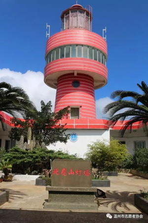
1990. Active; focal plane 135 m (443 ft); three white flashes every 20 s. 20 m (66 ft) square cylindrical concrete tower with lantern and a round control center, rising from a U-shaped 1-story concrete crew building and signal station. Tower covered with red ceramic tiles; the attached building is white with red trim and a red roof. A photo is at the top of this page, Huang Zuomin has a 2016 closeup, and Google has a good satellite view. Běijǐdǎo (Běijǐshān) is the largest and northernmost of the Běijǐ Islands, an isolated group about 50 km (30 mi) southeast of Wēnzhōu. Located at the highest point of the island. Site status unknown. ARLHS PRC-007; CN-2794.1; Admiralty P3650; NGA 19086.
Tóngqiánjiāo (Tóngqián Jiāo)
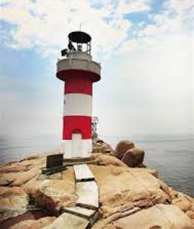
Date unknown. Active; focal plane 9 m (30 ft); two white flashes every 5 s. 8 m (26 ft) round cylindrical concrete tower, painted black with a red horizontal band. No photo available but Google has a satellite view. Located at the west end of a long reef about 5 km (3 mi) northwest of the Běijǐdǎo lighthouse. Accessible only by boat. Site open, tower closed. CN-2793.9; Admiralty P3652.
Dōngguāyǔ (Dōngguā Yǔ, Dongqua Hsu) (3)
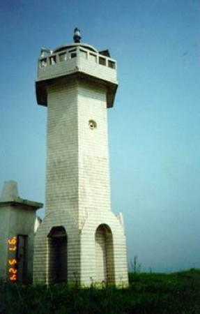
1995 (station established 1908). Active; focal plane 79 m (259 ft); two white flashes every 6 s. 13 m (43 ft) square cylindrical concrete tower with lantern and gallery, covered with white ceramic tiles; lantern roof painted red. A photo is at right, a page for the lighthouse has distant views and Google has a satellite view. The original lighthouse, described as "brick and wood," was replaced after being damaged during World War II by a 7.5 m (25 ft) cast iron tower. A dōngguā is a winter melon; the island is said to resemble a melon lying on its side. Located on a small island about 13 km (8 mi) west of Běijǐdǎo. Accessible only by boat. Site status unknown. CN-2796; Admiralty P3655; NGA 19085.7.
Tiějiāo (Tiě Jiāo) (2)
Date unknown. Active; focal plane 28 m (92 ft); three white flashes every 10 s. 8 m (26 ft) white concrete tower. No photo available but Bing has a satellite view. The 2017 MSA list describes a 5.5 m (18 ft) post. Located on a small island about 5 km (3 mi) north northwest of Dōngguāyǔ. Accessible only by boat. Site status unknown. CN-2796.5; Admiralty P3656; NGA 19085.3.

Ruì'ān City: Dàběi Islands Lighthouses
Běilóngshān (Běilóng Shān, Peilung Shan) (2)
2001 (station established 1970). Active; focal plane 37 m (121 ft); white flash every 6 s. 10 m (33 ft) square cylindrical concrete tower with gallery, covered with white ceramic tiles. No photo available and the light is not seen in Google's indistinct satellite view. Běilóngshān is an inhabited island about 20 km (13 mi) off the mainland coast and a similar distant west of Běijǐdǎo. Located at the west end of the island. Accessible only by boat. Site status unknown, but possibly accessible. CN-2798; Admiralty P3648.8; NGA 19085.5.
Lùsījiāo ("Heron Rock")
Date unknown. Active; focal plane 9.5 m (31 ft); white flash every 3 s. 5.5 m (18 ft) round white concrete tower. No photo available but Google has a fuzzy satellite view. Located atop an islet just off the northern tip of Běilóngshān. Accessible only by boat. Site status unknown. CN-2797; Admiralty P3648.7.
Lìzhīshān (Lìzhī Shān) (2)
1978 (station established 1955). Active; focal plane 89 m (292 ft); three white flashes every 10 s. 9.5 m (31 ft) round cylindrical concrete tower with gallery, painted with red and white horizontal bands. No photo available but Google has an indistinct satellite view. Located atop a small island about 7 km (4.5 mi) west northwest of Běilóngshān. Accessible only by boat. Site status unknown. CN-2799; Admiralty P3648.6; NGA 19085.

Dōngguāyǔ Light, Dàběi Islands, Ruì'ān
unattributed (probably MSA) photo
Pánzàoyǔ (Pánzào Yǔ)
Date unknown. Active; focal plane 25 m (82 ft); white flash every 6 s. 10 m (33 ft) round cylindrical white concrete tower. No photo available but the tower is seen in Google's satellite view. Located on a reef about 4 km (2.5 mi) east of the Lìzhīshān light. Accessible only by boat. Site status unknown. CN-2799.5; Admiralty P3648.65.
Liánhuājiāo (Liánhuā Jiāo)
Date unknown. Active; focal plane 16 m (52 ft); white flash every 4 s. 8 m (26 ft) round cylindrical white concrete tower. No photo available but Google has a satellite view. Located on a reef about 5 km (3 mi) east of the Fènghuángdàn light. Accessible only by boat. Site status unknown. CN-2806; Admiralty P3648.5.
Chángbáshān
Date unknown. Active; focal plane 16.5 m (54 ft); white flash every 5 s. 8.5 m (28 ft) round cylindrical concrete tower painted with red and white horizontal bands. No photo available and the lighthouse is not seen in Bing's fuzzy satellite view. Located on a small island about 1.6 km (1 mi) southeast of the Fēiyún River entrance. Accessible only by boat. Site status unknown. CN-2808.1; Admiralty P3648.47.
Fènghuángdàn (Fenghuangdao Jiao)
Date unknown. Active; focal plane 9 m (30 ft); two white flashes every 5 s. 9 m (30 ft) round cylindrical concrete tower painted black with one red horizontal band. No photo available but Bing has a satellite view. Located on a reef about 8 km (5 mi) east northeast of the Fēiyún River entrance. Accessible only by boat. Site status unknown. CN-2808; Admiralty P3648.48.
Xiàgànshān (Xiàgàn Shān)
Date unknown. Active; focal plane 24 m (79 ft); white flash every 6 s. 7 m (23 ft) round cylindrical white concrete tower. No photo available but Google has a satellite view. Located on a small island about 10 km (6 mi) east northeast of the Fēiyún River entrance. Accessible only by boat. Site status unknown. CN-2808.15; Admiralty P3648.43.
Běichǐtóu (Běichǐ Tóu)
Date unknown. Active; focal plane 9 m (30 ft); four white flashes every 12 s. 7 m (23 ft) round cylindrical white concrete tower. No photo available and the tower is hard to find in Google's satellite view. Located on a small island about 2.5 km (1.5 mi) south of Xiàgànshān light. Accessible only by boat. Site status unknown. CN-2808.3; Admiralty P3648.44.
Xiǎozhèngjiāo
Date unknown. Active; focal plane 13 m (43 ft); three white flashes every 10 s. 8 m (26 ft) white concrete tower. No photo available but Google has a satellite view. The 2017 MSA list describes an 8 m (26 ft) post. Located on a reef about 15 km (9 mi) east of the Fēiyún River entrance. Accessible only by boat. Site status unknown. CN-2808.2; Admiralty P3648.46; NGA 19085.6.

Ruì'ān Harbor (Fēiyún River) Lighthouses
Dōngshānxiàbù (Dōngshān Lower Wharf)
Date unknown. Active; focal plane 7 m (23 ft); white flash every 4 s. 7 m (23 ft) concrete tower painted with black and white horizontal bands. No photo available and the light has not been found in Google's satellite view. Located among the docks on the north side of the Fēiyún River in Ruì'ān. Site status unknown. CN-2812; Admiralty P3648.83.
Sòngjiādài
Date unknown. Active; focal plane 8 m (26 ft); red flash every 4 s. 7 m (23 ft) concrete tower painted with red and white horizontal bands. No photo available but Google has a satellite view. Located among the docks on the south side of the Fēiyún River in Ruì'ān. Site status unknown. CN-2813; Admiralty P3648.82.
Báitǎjiāo
Date unknown. Active; focal plane 7 m (23 ft); two white flashes every 8 s. 10 m (33 ft) concrete tower painted with red and white horizontal bands. No photo available Google has an indistinct satellite view. Located beside one of the piers of a double-track railroad bridge crossing the Fēiyún River in Ruì'ān. Site status unknown. CN-2813.1; not listed by the Admiralty.

Píngyáng County: Nánjǐ Islands Lighthouses
The Nánjǐ (Southern Jǐ) Islands are a compact group clustered around the largest island, Nánjǐshān, about 20 km (13 mi) southwest of Běijǐdǎo. The islands are administered as part of Píngyáng County.
Dàotiāoshān (Dàotiāo Shān)
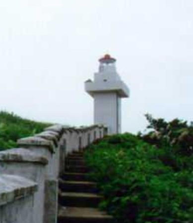
2007(?). Active; focal plane 25 m (82 ft); white flash every 8 s. 11 m (36 ft) round concrete tower with lantern and gallery, colored with red and white horizontal bands. A photo is at right and Google has an indistinct satellite view. Located on a small island on the northeast corner of the Nánjǐ Islands. Accessible only by boat. Site status unknown. CN-2800.5; Admiralty P3649.8.
Lóngtóu Yǔ (Longzuitou, Longzui Tou) (2)
1964 (station established 1958). Active; focal plane 71 m (233 ft); white flash every 4 s. 9.5 m (31 ft) round cylindrical concrete tower with gallery, painted white. No photo available but Google has a satellite view. Located on an islet off the northwest coast of Nánjǐshān, the largest of the Nánjǐ Islands. Accessible only by boat. Site status unknown. CN-2800; Admiralty P3649.5.
Píngyǔ (Píng Yǔ, Nánjǐ Shān, Nan-chi Shan, Nánjǐ Lièdǎo) (3)
1998 (station established 1970). Active; focal plane 62 m (203 ft); two white flashes every 12 s. 12 m (39 ft) round cylindrical concrete tower with gallery, covered with white ceramic tiles. An external stairway winds wround the lower half of the tower. No photo available but Google has a satellite view. Píngyǔ ("Flat Island") is a common name for Chinese islands and lighthouses. Located on an islet about 5 km (3 mi) off the south coast of Nánjǐshān. Accessible only by boat. Site status unknown. CN-2802; Admiralty P3649; NGA 19086.5.
Shàngmǎ'āndǎo (Shàngmǎ'ān Dǎo, Turret Island, Saddle Island) (2)
1970 (station established 1962). Active; focal plane 92 m (310 ft); three white flashes every 10 s. 10 m (33 ft) round cylindrical stone tower with gallery, painted with black and white horizontal bands. No photo available but Google has a fuzzy satellite view. Located on an isolated high island about 8 km (5 mi) west of Nánjǐshān. Accessible only by boat. Site status unknown. CN-2805; Admiralty P3649.3; NGA 19086.3.

Píngyáng County: Ào River Lighthouse
Shīzǐkou
Date unknown. Active; focal plane 26 m (85 ft); two white flashes every 6 s. 8 m (26 ft) square cylindrical concrete tower. Entire lighthouse is white. No photo available but Google has a distant satellite view. Located atop a steep bluff on the north side of the Ào River. Site status unknown. CN-2816; Admiralty P3648.388.

Dàotiāoshān Light, Píngyáng
unattributed (probably MSA) photo (no longer online)

Lónggǎng City: Southern Dàběi Islands Lighthouses
Sìyǔ (Sì Yǔ)
Date unknown. Active; focal plane 21 m (69 ft); white flash every 4 s. 8 m (26 ft) round cylindrical white concrete tower. No photo available but Google has a satellite view. Located on a small island about 10 km (6 mi) east northeast of the Fēiyún River entrance. Accessible only by boat. Site status unknown. CN-2814; Admiralty P3648.4.
Shàngèryǔ
Date unknown. Active; focal plane 34.5 m (113 ft); three white flashes every 10 s. 8 m (26 ft) concrete tower painted with red and white horizontal bands. No photo available but Google has a satellite view. Located on a small island about 4 km (2.5 mi) southwest of Sìyǔ. Accessible only by boat. Site status unknown. CN-2814.1; Admiralty P3648.385.
Shàntóuyǔ
Date unknown. Active; focal plane 64.5 m (211 ft); two white flashes every 6 s. 9.5 m (31 ft) white concrete tower. No photo available but Google has a satellite view. Located on a small island about 2.5 km (1.5 mi) southwest of Shàngèryǔ. Accessible only by boat. Site status unknown. CN-2815; Admiralty P3648.38.
Chángyāoshān (Dongguashan, Donggua Shan)
Date unknown. Active; focal plane 29 m (95 ft); two white flashes every 6 s. 8 m (26 ft) round concrete tower colored with red and white horizontal bands. No photo available but Google has a distant satellite view. Located on a small island about 5 km (3 mi) southwest of Shàntóuyǔ. Accessible only by boat. Site status unknown. CN-2815.1; Admiralty P3648.37.

Cāngnán County Lighthouses
Cāngdiàndītóu (Cāngdiàn Pier Head)
Date unknown. Active; focal plane about 17 m (56 ft); four yellow flashes in a long-short-long-short pattern (Morse code "C") every12 s. 14 m (46 ft) round yellow concrete tower. Google has a satellite view. Located at the end of a 3 km (1.8 mi) long breakwater pier built to create a sheltered harbor on the north side of Cape Píngyáng. Site status unknown. CN-2824.6; Admiralty P3648.36.
* Píngyáng Zuǐ (Píngyáng Tsui, Cape Píngyáng) (3)
1992 (station established 1955). Active; focal plane 66 m (217 ft); white flash every 5 s. 10 m (33 ft) hexagonal cylindrical stone tower with gallery, covered with white ceramic tiles. MSA's photo is at right, and Google has a satellite view. This lighthouse is on the mainland and accessible by road. Located on the cape, about 8 km (5 mi) northeast of Jinxiang. Site open, tower closed. CN-2825; Admiralty P3648.35.
Bǎimǔjiāo
Date unknown. Active; focal plane 9 m (30 ft); two white flashes every 5 s. 9 m (30 ft) round cylindrical concrete tower, painted black with a red horizontal band. No photo available but Bing has a distant satellite view of the reef. Located on an isolated reef about 20 km (13 mi) off the coast of Cāngnán County. Accessible only by boat. Site open, tower closed. CN-2826; Admiralty P3648.3.
Jiāobēidǎo (Jiāobēi Dǎo) (2)
1989 (station established 1955). Active; focal plane 32 m (105 ft); two white flashes every 6 s. 10 m (33 ft) round cylindrical stone tower with gallery, painted black. No photo available but Google has a satellite view. Located on an isolated pinnacle in the entrance to Dàyú Bay, about 10 km (6 mi) east of Zhōngdūn. Accessible only by boat. Site status unknown. CN-2827; Admiralty P3648.28.
Dǐngcǎoyǔ (Dǐngcǎo Yǔ, Qao Yu, Tsao Hsu, Toe Point) (2)
1987 (station established 1955). Active; focal plane 58 m (190 ft); white flash every 3 s. 9 m (30 ft) round stone tower with gallery, painted white. A 1-story equipment room is adjacent to the lighthouse. No photo available but Google has a satellite view. Located at the eastern tip of a small island just off the mainland coast southeast of Mǎzhàn. Accessible only by boat. Site status unknown. CN-2828; Admiralty P3648.25.
Wángjiāo (Wáng Jiāo) (2)
1989 (station established 1955). Active; focal plane 22 m (72 ft); three white flashes every 10 s. 13 m (43 ft) 2-stage round cylindrical stone tower with gallery, covered with white ceramic tiles. No photo available but Bing has a satellite view. Located on a reef off the southeastern tip of an island a few miles north of the Fújiàn border. Accessible only by boat. Site status unknown. CN-2831; Admiralty P3648.18. Accessible only by boat. Site status unknown. CN-2831; Admiralty P3648.18.
Xiàguānmén ("Lower Guān Gate")
Date unknown. Active; focal plane 9.5 m (31 ft); four white flashes every 12 s. 7 m (23 ft) white concrete tower. No photo available but Google has a satellite view. Located on an islet just off the northeast shoulder of the island of Guāndǎo, marking the entrance to Yánpǔ Bay. CN-2832; Admiralty P3648.14.
Pingyang Zui Light
Píngyáng Zuǐ Light, Lónggǎngzhèn, May 1997
PRC MSA Shànghǎi Region photo
Nánguāndǎo (Nán Guāndǎo, Nankuanshan) (2)
1990 (station established 1955). Active; focal plane 67 m (220 ft); two white flashes every 6 s. 10 m (33 ft) 12-sided stone (?) tower with gallery, painted with black and white horizontal bands. No photo available but Google has a satellite view. Nánguāndǎo is an inhabited island in the mouth of the Guān (Kuan) river, the border between Zhèjiāng and Fújiàn. Located on the southern tip of the island. Site status unknown, possibly accessible. CN-2833; Admiralty P3648.15.

Information available on lost lighthouses:

Notable faux lighthouses:

Adjoining pages: North: Wēnzhōu Area | South: Ningde, Fújiàn

Return to the Lighthouse Directory index | Ratings key

Posted June 9, 2008. Checked and revised December 27, 2023. Lighthouses: 34. Site copyright 2023 Russ Rowlett and the University of North Carolina at Chapel Hill.