Lighthouses of Western Colombia

TThe Republic of Colombia occupies the northwestern corner of South America. Connected to North America by the Isthmus of Panama, Colombia has coasts facing west on the Pacific Ocean and northwest on the Caribbean Sea. Colombia was colonized by Spain early in the 16th century and was ruled as part of the Viceroyalty of New Granada until the viceroyalty won its independence in a complex struggle in 1810-1819. The former viceroyalty, known as Gran Colombia, fell apart in 1831, creating the nations of Colombia, Venezuela, and Ecuador. Colombia continued to include the area of Panama until that country became independent in 1903.

Colombia is divided into 33 departments (departamentos); four of the departments face the Pacific. The departments are subdivided into municipalities (municipios). This page includes the lighthouses of the Pacific coast; there's a separate page for the North Coast lighthouses and another for Colombia's Caribbean territory of San Andrés and Providencia. Except for the ports of Tumaco and Buenaventura the Pacific coast of Colombia is mostly wild and remote. As a result most of Colombia's Pacific lighthouses are in relatively inaccessible locations and only limited information is available about them.

The Spanish word for a lighthouse is faro; isla is an island, cabo is a cape, punta is a promontory or point of land, péñon is a rock, arrecife is a reef, bahía is a bay, ría is an estuary or inlet, estrecho is a strait, río is a river, and puerto is a port or harbor. Also, the Spanish word canal means a natural channel, not an artificial canal.

Aids to navigation in Colombia are owned by the Autoridad Marítima Colombia and maintained by the Dirección General Marítima (DIMAR).

ARLHS numbers are from the ARLHS World List of Lights. DIMAR numbers are from DIMAR's Lista de Luces de la República de Colombia. Admiralty numbers are from volume G of the Admiralty List of Lights & Fog Signals and U.S. NGA numbers are from Publication 111.

General Sources
Online List of Lights - Vol. G - Colombia
Photos by Capt. Peter Mosselberger ("Capt. Peter"), posted by Alexander Trabas.
Lighthouses in Colombia
Photos by various photographers available from Wikimedia.
World of Lighthouses - Colombia
Photos by various photographers available from Lightphotos.net.
Lista de Luces
2015 light list for Colombia, originally posted by DIMAR.
GPSNavigationCharts
Navigation Chart information for the Colombian coast.
Navionics Charts
Navigation chart for Colombia's Pacific coast.


Parque Colpuertos Light, Buenaventura, November 2017
ex-Google Plus photo by Carlos AMS

Nariño Department (Tumaco Area) Lighthouses
Tumaco is a seaport of about 250,000 residents near the Ecuadorian border.
#Cabo Manglares (1)
Date unknown. Apparently collapsed. Approx. 25 m (82 ft) square skeletal tower painted with red and white horizontal bands. Long endangered: the tower was undermined and had a lean of at least 25°. Camilo Monroy has a 2007 photo but no tower is seen in Bing's satellite view. Located on the south side of the mouth of the Río Mira estuary, about 1.5 km (1 mi) southwest of the current Cabo Manglares lighthouse. Accessible only by boat, Site open, tower closed.
Cabo Manglares (2)
Date unknown. Active; focal plane 41 m (135 ft); three white flashes every 15 s. 36.5 m (120 ft) round fiberglass tower colored with red and white horizontal bands. A photo is at right and another photo is available but Bing has only a fuzzy satellite view. Located on a low but prominent cape on the north side of the mouth of the Río Mira estuary about 45 km (28 mi) southwest of Tumaco and a similar distance northwest of the Ecuadorian border. Site status unknown. ARLHS COL-005; DIMAR-P019; Admiralty G3122; NGA 0232.
Rada Tumaco Range Front
Date unknown. Active; focal plane 12 m (39 ft); two white flashes every 5 s. 12 m (39 ft) square pyramidal skeletal tower. No photo available but Google has a satellite view. This is an approach range for Tumaco. Located in a wetland about 5 km (3 mi) west of the Tumaco lighthouse. Site status unknown. DIMAR-P131; Admiralty G3125.4; NGA 0226.
Rada Tumaco Range Rear
Date unknown. Active; focal plane 25 m (82 ft); two white flashes every 5 s. 24 m (79 ft) square pyramidal skeletal tower. No photo available but Google has a satellite view. Located about 100 m (110 yd) south of the front light. Site status unknown. DIMAR-P132; Admiralty G3125.5; NGA 0227.

Cabo Manglares Light, Nariño Department
unattributed photo from Mostpoint.com
Tumaco
Date unknown (station established 1922). Active; focal plane 92 m (305 ft); flash every 10 s, alternating red and white. 11 m (36 ft) square cylindrical concrete tower with lantern and gallery; a platform carrying communications gear has built over the top of the lantern. Lighthouse painted with red and white horizontal bands. Anthony Tice contributed the photo at right, a view from the harbor is available, and Google has a satellite view. Since Tice took his photo in 2007 a tall harbor control tower has been built next to the lighthouse. The lighthouse is located on a Colombian naval base. Located on an island sheltering the harbor of Tumaco on Colombia's southernmost coast. Site and tower closed (military reservation), but the lighthouse can be seen distantly from the main gate of the base. ARLHS COL-054; DIMAR-P018; Admiralty G3124; NGA 0220.
El Viudo (2)
2018. Active; focal plane 20 m (66 ft); two white flashes every 5 s. 20 m (66 ft) round barbell-shaped metal tower painted with black and red horizontal bands and mounted on a square concrete base. A photo is available but the light is not shown in Google's satellite view. Until 2018 the light was described as a 12 m (39 ft) tower. The contract advertisement for the new tower described a metal structure on a concrete base. The light marks shoals on the west side of the entrance to Tumaco; the shoal is called El Viudo ("The Widower"). Located about 4 km (2.5 mi) north of the harbor entrance. Accessible only by boat. Site open, tower closed. DIMAR-P134; Admiralty G3124.5; NGA 0224.
Pasa Caballos
Date unknown. Active; focal plane 43 m (141 ft); two white flashes every 20 s. 36 m (118 ft) square skeletal tower painted with red and white horizontal bands. Pilar Vasquez Aguirre has a 2020 photo and Google has a satellite view. Located at the entrance to the Río Patía, about 80 km (50 mi) north of Tumaco. Site status unknown. DIMAR-P017; Admiralty G3126; NGA 0216.
Faro de Tumaco
Tumaco Light, Tumaco, September 2007
photo copyright Anthony Tice; used by permission

Cauca Department Lighthouses
Bocana Guapi (Río Guapi) (2)
2019. Active; focal plane 43 m (141 ft); two white flashes every 15 s. 40 m (131 ft) square skeletal tower, the upper half enclosed, colored with red and white horizontal bands. A photo is available but the tower is not seen in Bing's satellite view. This lighthouse replaced a skeletal tower 12 m (39 ft) tall. Located on the east side of the entrance to the Río Guapi, about 15 km (9 mi) north of the town of Guapi. Accessible only by boat. DIMAR-P016; Admiralty G3130.1; NGA 0213.
Timbiqui (Punta Chacón)
Date unknown (2008?). Active; focal plane 13 m (43 ft); two white flashes every 25 s. 18 m (59 ft) skeletal tower, painted with red and white horizontal bands. No photo available but Bing has a satellite view. Located on the Isla Bubuey, on the north side of the Bahía de Timbiqui. Site status unknown. DIMAR-P015; Admiralty G3130.5; NGA 0214.
Punta Coll (Isla Gorgona) (2)
2020. Active; focal plane about 77 m (252 ft); one long (2 s) white flash every 8 s. 30 m (98 ft) square skeletal tower, upper portion enclosed, painted with red and white horizontal bands. A contractor Lineal Engineering installed the new lighthouse and has the photo seen at right, David Bermudez has a 2022 distant view, and Bing has an indistinct satellite view. Gorgona is an island about 50 km (30 mi) off the Colombian coast halfway between Buenaventura and Tumaco. Formerly the site of a political prison, the island is now a national park with facilities for ecotourism. Located at the northern tip of the island. Site status unknown. ARLHS COL-063; DIMAR-P012; Admiralty G3129; NGA 0210.
Gorgona Centro (Parque Gorgona) (2)
2020. Active; focal plane 8 m (26 ft); two white flashes every 12 s. 8 m (26 ft) round fiberglass tower colored with red and white horizontal bands mounted on a concrete platform supported by piles. A contractor Lineal Engineering installed the new lighthouse and has a photo (halfway down the page, on the left). Jorge Tarazona has a 2021 view from the sea but overhanging trees hide the light in Bing's satellite view. The light guides vessels to the former prison, now the site for ecotourism activities. The Admiralty announced the new light but kept the description of the old one, seen in Capt. Peter's photo. Located on the central east coast of Isla Gorgona. Site open, tower closed. DIMAR-P013; Admiralty G3128.5; NGA 0211.
Isla Gorgonilla
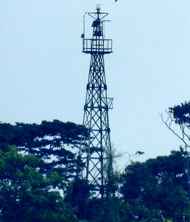
Date unknown. Active; focal plane 103 m (338 ft); white flash every 15 s. Approx. 18 m (59 ft) skeletal tower painted with red and white horizontal bands. Trabas has Capt. Peter's photo and Bing has an indistinct satellite view. According to Lineal Engineering this lighthouse was also to be replaced in 2020, but no information on a new lighthouse is available. Located at the highest point, near the northeastern end, of Isla Gorgonilla, a smaller island off the southwestern tip of Isla Gorgona. DIMAR-P014; Admiralty G3128; NGA 0212.

Punta Coll Light, Isla Gorgona, 2020
photo posted by Lineal Engineering

Valle de Cauca Department (Buenaventura Area) Lighthouses
A city of nearly 450,000 residents, Buenaventura is Colombia's metropolis and principal port on the Pacific. The central part of the city is on an island, Isla Cascajal, embedded in the delta of several converging rivers.

Bocana Río Naya (?)
Date unknown. Inactive since 2015. 12 m (39 ft) skeletal tower, painted with red and white horizontal bands. No photo available. This tower probably has been removed; it is not seen in Bing's satellite view. Located on the north side of the mouth of the Río Naya, which is the border between the departments of Cauca and Valle de Cauca. Site status unknown. ARLHS COL-066; ex-DIMAR-P014; ex-Admiralty G3131.5; ex-NGA 0215.5.
Punta Soldado
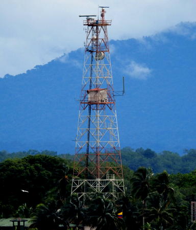
Date unknown. Active; focal plane 50 m (164 ft); white flash every 10 s. Approx. 47 m (154 ft) square skeletal tower with gallery, painted with red and white horizontal bands. The tower also carries a radar antenna, and there is a small equipment shelter about 2/3 the way up the tower. Trabas has Capt. Peter's photo (also seen at right) and Google has a satellite view of the station. Located on the south side of the entrance to the Bahia de Buenaventura. Site status unknown. ARLHS COL-065; DIMAR-P011; Admiralty G3132; NGA 0200.
** Parque Colpuertos (Buenaventura)
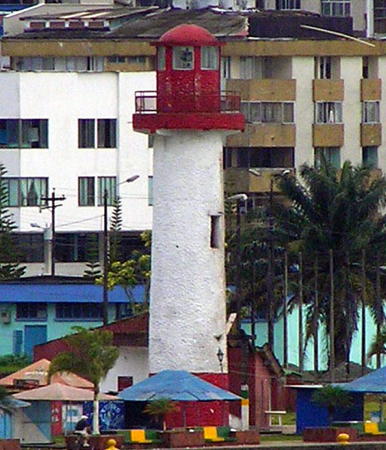
Date unknown. Inactive since 2014. 17 m (56 ft) cylindrical tower, painted white with a red band at the base; lantern painted red. A photo is at the top of his page, Trabas has Capt. Peter's photo also showing the red lantern, a 2020 photo is available, Wikimedia has Shaun McRae's 2005 photo, Gustavo Parra has a 2017 street view, and Google has a satellite view. This lighthouse is located in a public park on the waterfront in Buenaventura. Site open, and there are photos showing visitors on the gallery. ARLHS COL-056; ex-DIMAR-P012; ex-Admiralty G3133.03; ex-NGA 0203.3.
* La Pilota (Directional Light)
Date unknown. Active; focal plane 44 m (144 ft); white flash every 5 s, visible only along the line of approach to the port. 30 m (98 ft) water tower with a large round tank; the light is centered atop the tank. The tank is painted a silver color with a red top. Trabas has Capt. Peter's photo and Google has a street view and a satellite view. The leading light guides ships in the estuary approaching the city. Located at Calle 4 and Carrera 13 in Buenaventura. Site open, tower closed. DIMAR-P100; Admiralty G3133; NGA 0202.
#Las Delicias Range Rear
Date unknown. Removed (in 2018?). This was an approx. 16 m (52 ft) square wood skeletal tower, painted red with a white horizontal band. Trabas has Capt. Peter's photo but Google's satellite view shows that a new container terminal occupies the location. Located on the north bank of the Buenaventura estuary, across from the city's waterfront. Site status unknown. ex-DIMAR-P079; ex-Admiralty G3133.51; ex-NGA 0208.
Arrieral (2)
2018. Active; focal plane 18 m (59 ft); white, red or green light depending on direction, 1.5 s on, 2.5 s off. Approx. 12 m (39 ft) round tower colored with red and white horizontal bands. Trabas has Capt. Peter's photo and Google has a satellite view. The Admiralty and NGA list the tower height as 5 m (16 ft) but this must refer to a previous tower. Located on a forested point across from the city's waterfront. Site status unknown. DIMAR-P102; Admiralty G3133.07; NGA 0202.6.

Punta Soldado Light, Buenaventura
photo copyright Capt. Peter Mosselberger; used by permission
Isla Palmas (Isla la Palma) (3?)
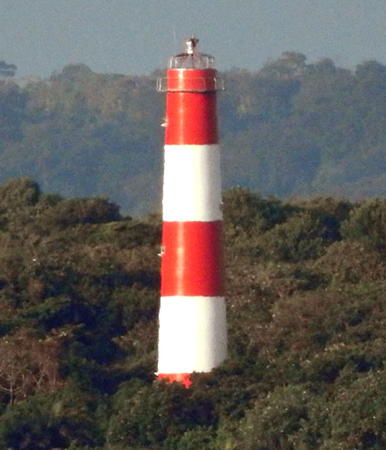
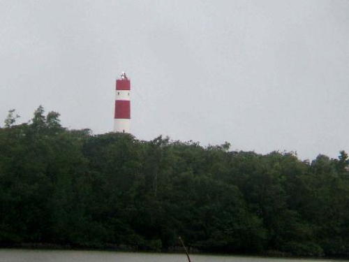
2017 (station established 1922). Active; focal plane 46 m (151 ft); two white flashes every 20 s. 39 m (128 ft) round tower colored with red and white horizontal bands. Trabas has Capt. Peter's photo (also seen at right), Eduard Echavarria has a February 2018 photo, and Google has a satellite view. This lighthouse replaced a square pyramidal skeletal tower painted with red and white horizontal bands. Located on an island at the northern entrance to the Bahía de Buenaventura. Accessible only by boat. Site status unknown. ARLHS COL-058; DIMAR-P010; Admiralty G3136; NGA 0188.
Bahía Málaga B
Date unknown. Active; focal plane 15 m (49 ft); white light, 2 s on, 2 s off. 15 m (49 ft) square white skeletal tower mounted on a platform supported by piles. No photo available but Google has a satellite view. Located off the northern tip of Isla Palmas. Accessible only by boat. Site open, tower closed. DIMAR-P040; Admiralty G3137; NGA 0189.
Bahía Málaga C
Date unknown. Active; focal plane 15 m (49 ft); two white flashes every 12 s. 15 m (49 ft) square white skeletal tower mounted on a platform supported by piles. Trabas has Capt. Peter's distant view, the lighthouse is on the right side of Elkin Bolkam's panoramic view, Gerardo Becerra has a very distant street view from the shore, and Google has a satellite view. Located off Juanchaco. Accessible only by boat. Site open, tower closed. DIMAR-P041; Admiralty G3137.5; NGA 0190.
[Isla de Malpelo]
Date unknown. Active; focal plane 258 m (846 ft); white flash every 15 s. 4 m (13 ft) skeletal mast, painted orange. Amateur radio operator HK0NA has a photo (halfway down the page) and the light is probably centered in Google's satellite view. Malpelo is an isolated island about 380 km (235 mi) off Colombia's Pacific coast. It is impossible to land a boat on the island; a crane (third photo on the page) is used to receive supplies. The Colombian military maintains a small outpost on the island. The island is protected as a natural park and is a UNESCO World Heritage Site. Site and tower closed (nearly inaccessible). DIMAR-P009; Admiralty G3142; NGA 0186.

Chocó Department Lighthouses
Punta Charambirá
Date unknown. Active; focal plane 36 m (118 ft); white flash every 12 s. 36 m (118 ft) square skeletal tower painted with red and white horizontal bands. No photo available but Bing has a satellite view. Located at the seaward edge of the Río San Juan, near the southern border of the province. Site status unknown. DIMAR-P008; Admiralty G3140; NGA 0184.

Isla Palmas Light, Buenaventura
photo copyright Capt. Peter Mosselberger; used by permission
Pizarro (1)
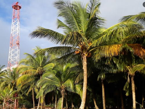
Date unknown. Inactive since 2010. Approx. 20 m (66 ft) square cylindrical skeletal tower painted with red and white horizontal bands. Henry Hurtado has the 2021 view from the sea seen at right.
Pizarro (2)
2010 (station establishment date unknown). Active; focal plane 28 m (92 ft); two white flashes every 10 s. 18 m (72 ft) square skeletal tower, upper half enclosed, painted with red and white horizontal bands. Henry Hurtado has the 2021 view from the sea seen at right and Google has a satellite view. Located at Pizarro, a village in southern Chocó. Site status unknown. DIMAR-P007; Admiralty G3143; NGA 0183.
Cabo Corrientes
Date unknown. Active; focal plane 189 m (620 ft); white flash every 10 s. 18 m (59 ft) tower, presumably skeletal, painted with red and white horizontal bands. No photo available and the tower has not been found in Google's satellite view of the cape. Located on a prominent cape roughly midway between Punta Ardita and Buenaventura. Accessible only by boat. Site and tower closed. ARLHS COL-015; DIMAR-P006; Admiralty G3145; NGA 0182.
Nuquí
2007. Active; focal plane 63 m (207 ft); two white flashes, separated by 3 s, every 20 s. 28 m (92 ft) square skeletal tower, painted with red and white horizontal bands. Gerson Parra has a sea view and Bing has a satellite view. Nuquí is a village of about 3000 residents. Located on a promontory sheltering the bay of Nuquí. Site status unknown. ARLHS COL-059; DIMAR-P005; Admiralty G3147; NGA 0181.
 

New and old Pizarro Lights, Chocó, January 2021
Google Maps photo by Henry Hurtado
 
San Francisco Solano (Punta Solano)
Date unknown. Active; focal plane 44 m (144 ft); white light, 2 s on, 10 s off. 20 m (66 ft) skeletal tower, painted with red and white horizontal bands. No photo available but Bing has an indistinct satellite view. Located on a sharp promontory sheltering the Bahía Solano. Site status unknown. ARLHS COL-064; DIMAR-P003; Admiralty G3150; NGA 0176.
Mutis
Date unknown. Active; focal plane 15 m (49 ft); green flash every 6 s; this is a leading light visible only along the line of approach to the port. Approx. 13 m (43 ft) tower painted with red and white horizontal bands. No photo available and the light is not seen in Bing's satellite view of the area. Located northeast of the town of Mutis (Bahía Solano). Site status unknown. DIMAR-P004; Admiralty G3152; NGA 0180.
Cabo Marzo
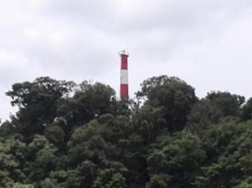
Date unknown. Active; focal plane 68 m (223 ft); white flash every 15 s. 18 m (59 ft) round fiberglass tower colored with red and white horizontal bands. Eduar Humberto Echávarria has a view from the sea (a portion is seen at right) and Google has a satellite view. Located on a small island just off a prominent cape about 50 km (30 mi) southeast of the Panamanian border. Site status unknown. ARLHS COL-057; DIMAR-P002; Admiralty G3153; NGA 0174.
Punta Ardita
2003. Active; focal plane 170 m (558 ft); two white flashes every 25 s. 30 m (98 ft) tower square pyramidal skeletal tower painted with red and white horizontal bands. No photo available but Bing has a distant satellite view. In northwestern Colombia the Baudó mountains rise very steeply from the Pacific coast, and this lighthouse stands on the northernmost major promontory. Located about 8 km (5 mi) southeast of the Panamanian border. Accessible only by boat. Site and tower closed. ARLHS COL-060; DIMAR-P001; Admiralty G3153.2; NGA 0172.

Cabo Marzo Light, Chocó, August 2017
Google Maps photo by Eduar Humberto Echávarria

Information available on lost lighthouses:

Adjoining pages: North: Colombia Caribbean | South: Ecuador | West: Southern Panamá

Return to the Lighthouse Directory index | Ratings key

Posted February 13, 2004. Checked and revised October 1, 2023. Lighthouses: 30. Site copyright 2023 Russ Rowlett and the University of North Carolina at Chapel Hill.