Lighthouses of Ecuador

The Republic of Ecuador is located on the northern Pacific coast of South America between Colombia and Peru. It is in fact named for the Equator, which passes through the northern part of the country. Guayaquil is Ecuador's major seaport, but there are several others, including Puerto Bolívar in the south, Manta on the central coast, and Esmeraldas in the north.

Ecuador is divided into 24 provinces (provincias). This page includes lighthouses of the five provinces of the mainland coast. Ecuador also administers the Galápagos Islands and lights on those islands are described on a separate page.

The Spanish word for a lighthouse is faro; isla is an island, cabo is a cape, punta is a promontory or point of land, péñon is a rock, arrecife is a reef, bahía is a bay, ría is an estuary or inlet, estrecho is a strait, río is a river, and puerto is a port or harbor. Also, the Spanish word canal means a natural channel, not an artificial canal.

Aids to navigation in Ecuador are owned by the Navy (Armada del Ecuador) and maintained by the Aids to Navigation Department (Departamento de Ayudas a Navegación) of the Navy's Oceanographic Institute (Instituto Oceanográfico).

ARLHS numbers are from the ARLHS World List of Lights. EC numbers are Ecuadorian light list numbers, where known, as given by the Admiralty. Admiralty numbers are from volume G of the Admiralty List of Lights & Fog Signals. U.S. NGA List numbers are from Publication 111.

General Sources
Derrotero de la Costa Continental e Insular del Ecuador (pdf)
2005 edition of a coast pilot; it includes small photos of many of the lights.
Online List of Lights - Ecuador
Photos by various photographers posted by Alexander Trabas. The Ecuador photos are by Hendrik Martin Porath or Capt. Peter Mosselberger ("Capt. Peter").
World of Lighthouses - Equador
Photos by various photographers available from Lightphotos.net.
Phares d'Amérique
From their Phares du Monde web site, Alain Guyomard and Robert Carceller have photos of four lights in the Galápagos and two lights of the mainland.
Navionics Charts
Navigation chart for Equador.


Punta Santa Elena Light, Salinas, January 2018
Google Maps photo by Aventura Andrade

El Oro Province Lighthouses
El Oro is Ecuador's southernmost coastal province, located on the south shore of the Gulf of Guayaquil adjoining Perú. The province was named for its gold mine (oro is the Spanish word for gold), but today its economy is based on bananas. 80% of Ecuador's banana exports are shipped through the ports of Machala and Puerto Bolívar.

Payana (Isla San Gregorio) (2)
2021. Active; focal plane 18 m (39 ft); two white flashes every 2 s. 9 m (30 ft) (?) round tower colored with red and white horizontal bands. No photo available but Google has a satellite view. The tower appears taller than its listed height. The 2005 Derrotero has a small photo of the original lighthouse, also a round tower. The Admiralty reported the lighthouse "destroyed" in December 2020 and it appears from Google's satellite view of the former location that the light was lost to beach erosion. Located at the westernmost point of the Isla San Gregorio, just north of the Peruvian border. Site status unknown. ARLHS ECU-025; EC-1263; Admiralty G2998; NGA 0522.
Isla Santa Clara (5?)
Date unknown (station established 1841). Active; focal plane 81 m (266 ft); white flash every 10 s. 10 m (33 ft) square concrete skeletal tower with enclosed lower section. Two 1-story buildings. An INOCAR photo is at right, the 2005 Derrotero has a smaller version of the same photo, Jhison Romero has a very distant view from the sea, Bing has an indistinct satellite view and Google has a satellite view of the nearby station buildings. This is Ecuador's oldest light station; Lighthouse Digest has a drawing of the original lighthouse. The original wooden tower was replaced by a taller wooden tower in 1872 and then by an iron skeletal tower in 1921. The lantern and lens from the second lighthouse were purchased by the Guayaquil Yacht Club in 1956 and for two decades they were displayed on one of the club's buildings. After more than 15 years in storage the lantern and lens were installed in 1993 on the Salinas Yacht Club lighthouse (see below). Located atop the Isla Santa Clara, a small island in the middle of the southern entrance to the Bahía de Guayaquil, about 55 km (35 mi) west of Machala. Accessible only by boat; ecotours to the island, a well-known bird sanctuary, may be available. Site manager: Refugio de Vida Silvestre Santa Clara. Site status unknown. ARLHS ECU-001; Admiralty G2996; NGA 0508.
Punta Jambelí (Machala, Río Santa Rosa) (4?)
Around 2021 (station established 1882). Active; focal plane 18 m (59 ft); two white flashes every 10 s. 16 m (53 ft) round concrete tower painted with red and white horizontal bands. A photo is available and Google has a satellite view. The original lighthouse was a square wood tower. The present lighthouse replaced a similar tower that had gone to sea. Located on Punta Jambelí, a low point on the west side of the entrance to the Estero Santa Rosa, leading to Machala, the capital of El Rio Province. Site status unknown. ARLHS ECU-003; EC-1255; Admiralty G3028; NGA 0512.
* Puerto Bolívar
Date unknown. Active; focal plane 37 m (121 ft); two white flashes every 10 s, visible only along the line of approach to the harbor. Light mounted on the top of a 32 m (105 ft) square steel and masonry church steeple. Andrés Felipe Arias Palma has a 2012 photo showing the light at the top of the steeple, Joh De La Gasca has a 2015 photo, and Google has a street view and a satellite view. The church is called the Templo Faro (Lighthouse Temple). Puerto Bolívar is an important seaport near Machala at the southern entrance to the Bahía de Guayaquil; bananas and shrimp are the principal exports. Located on the waterfront of Puerto Bolívar. Site open, tower closed. EC-1261; Admiralty G3029; NGA 0520.
Bajo Salinas
Date unknown. Inactive since 2020. 13 m (43 ft) skeletal tower mounted on a square concrete platform supported by piles. No photo available but Google has a satellite view. Located on the east side of the entrance to the Estero Santa Rosa about 5 km (3 mi) north of Puerto Bolívar. ARLHS ECU-015; ex-EC-1258; ex-Admiralty G3028.6; NGA 0517.
Isla Santa Clara Light
INOCAR photo

Guayas Province: Canal de Jambelí and Río Guayas Lighthouses
Located at the head of the Gulf of Guayaquil, Guayas Province includes the seaport of Guayaquil itself, the provincial capital and Ecuador's second largest city, located at the head of the delta of the Río Guayas. The lights listed in this group are the largest among the many navigational aids guiding vessels to this major port. The large Isla de Puná dominates the entrance to the delta. The traditional entrance is through the Canal de Jambelí (Jambelí Channel), a broad passage on the east side of the island. A more recently developed entrance is through the Estero Salado west of the island.
Punta Arenas (4?)
Date unknown (station established 1873). Active; focal plane 20 m (66 ft); two white flashes every 15 s. 18 m (59 ft) skeletal tower, painted white, mounted on a square pier or platform. No photo available but the light is seen in Google's fuzzy satellite view. The original lighthouse was a 14 m (46 ft) square wood tower built on the southeastern point of the Isla de Puná. It was replaced in 1889 but the subsequent history of the station is unclear. A Fresnel lens from this lighthouse is displayed at the Hostería Galeriay Museo Náutico Farallón Dillon in Ballenita. Located off the southeastern tip of the Isla de Puná, marking the north side of the Canal de Jambelí. Accessible only by boat. Site open, tower closed. ARLHS ECU-002; EC-1216; Admiralty G3026; NGA 0500.
Punta Española (4?)
Around 2010 (station established 1874). Active; focal plane 21 m (69 ft); two white flashes every 12 s. 15 m (49 ft) skeletal tower, painted white. No photo available but Google has a satellite view. Located on a point of land near the northeastern tip of Isla de Puná. Accessible only by boat. Site open, tower closed. ARLHS ECU-034; EC-1221; Admiralty G3031; NGA 0496.
Punta Mandinga (5?)
Around 2010 (station established 1873). Active; focal plane 52 m (171 ft); two white flashes every 8 s. 15 m (49 ft) skeletal tower, painted white. No photo available but Bing has an indistinct satellite view. Located at the northeastern tip of Isla de Puná. Accessible only by boat. Site open, tower closed. ARLHS ECU-004; EC-1224; Admiralty G3032; NGA 0492.
Isla Verde
Date unknown. Active; focal plane 12 m (39 ft); white flash every 6 s. 12 m (39 ft) white metal tower mounted on a platform supported by piles. No photo available but Google has a satellite view. Located on the west side of the entrance to the Río Guayas, the route to Guayaquil's traditional waterfront. Accessible only by boat. Site open, tower closed. ARLHS ECU-020; Admiralty G3033; NGA 0488.
Punta de Piedra (2)
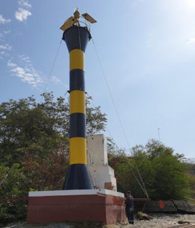
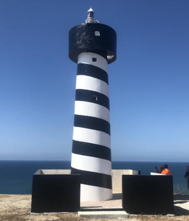
Date unknown. Active; focal plane 10 m (33 ft); red flash every 5 s. 10 m (33 ft) round barbell-shaped tower colored with black and yellow (formerly black and white) horizontal bands. Freddy Alejandro has the 2020 photo at right showing the newer black and yellow bands, David Rodriguez has a 2019 photo, a more distant view is available and Google has a satellite view. NGA previously listed a tower only 7 m (23 ft) tall. Located on the west side of the Río Guayas about 25 km (15 mi) south of Guayaquil's traditional waterfront. Accessible only by boat. Site open, tower closed. EC-1242; Admiralty G3035; NGA 0480.

Punta de Piedra Light, Guayaquil, August 2020
Google Maps photo by Freddy Alejandro

Guayas Province: Guayaquil Lighthouse
Guayaquil is the second largest city of Ecuador, with a population of more than 3 million.

*** [Cerro Santa Ana]
2002. Active (unofficial); focal plane 86 m (282 ft); continuous white light. 19 m (62 ft) round tower with lantern and gallery painted in a blue and white spiral pattern. (The city's flag features blue and white horizontal stripes.) A good photo is available, Konstantin Gul'tyayev has a street view and Google has a satellite view. This is certainly Ecuador's best known lighthouse, but it has no navigational value. Located on the Cerro Santa Ana, a prominent hill on the west side of Río Guayas and on the north side of downtown. Site open, tower open daily. .

Guayas Province: Estero Salado Lighthouses
The Estero Salado ("Salty Estuary") is the western approach to Guayaquil, leading the modern port.

Data de Posorja Range Rear
Date unknown. Active; focal plane 35 m (115 ft); white flash every 4 s. 23 m (75 ft) square skeletal tower with gallery, carrying a rectangular red daymark. Trabas has Porath's photo and Google has a street view and an indistinct satellite view. This is the first approach range guiding vessels approaching from the open sea to the west. The front light is on a skeletal mast, 1.05 km (0.65 mi) southwest. NGA lists the light as "DATA 2." Located in the village of Posorja, on the mainland side of the Canal del Morro. Site status unknown. EC-1101; Admiralty G3040.81; NGA 0450.1.
Estero Salado (Canal del Morro) A Range (Cauchiche Range) Rear
Date unknown. Active; focal plane 23 m (75 ft); white light, 2.5 s on, 2.5 s off. 20 m (66 ft) square skeletal tower, painted white. The tower also carries a slatted daymark, painted red with a white vertical stripe. Trabas has Capt. Peter's photo and Google has a satellite view. This is an approach range guiding vessels approaching along the coast from the northwest. The front light is on piles offshore, 1.8 km (1.1 mi) northwest. Located on the northwest side of the Isla de Puná. Site status unknown. Admiralty G3038.1; NGA 0456.
Los Farallones
Date unknown. Active; focal plane 20 m (66 ft); white flash every 4 s. 10 m (33 ft) triangular skeletal tower with gallery, carrying a rectangular red daymark. Trabas has Capt. Peter's closeup photo and Google has a distant satellite view. Located on the Isla de los Pajaros, a small island in the narrowest passage of the Canal del Morro, between the northwestern corner of the Isla de Puná and the mainland. Accessible only by boat. Site status unknown. EC-1112; Admiralty G3040.6; NGA 0460.
Estero Salado (Canal del Morro) B Range Rear (2)
Date unknown. Active; focal plane 33 m (108 ft); white light, 2.5 s on, 2.5 s off. 26 m (85 ft) square skeletal tower, painted white. The tower also carries a slatted daymark, painted red with a white vertical stripe. Trabas has Capt. Peter's photo and Google has a satellite view. This range guides ships northward through the narrow pasage of the Canal del Morro. The front light is on four piles, about 1100 m (0.7 mi) south. Located on the west side of the bay about 12 km (7.5 mi) southeast of Puerto Ayalan. Site status unknown. Admiralty G3041.1; NGA 0463.
Estero Salado C Range Rear (2)
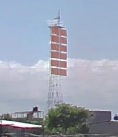
Date unknown. Active; focal plane 23 m (75 ft); white light, 2.5 s on, 2.5 s off. 23 m (75 ft) square skeletal tower, painted white, mounted on a platform supported by four piles. The tower also carries a slatted daymark, painted red with a white vertical stripe. Trabas has Capt. Peter's photo (also seen at right) and Google has an indistinct satellite view. This range guides ships northeastward on the north side of the Isla de Puná. The front light is on tripod piles about 1100 m (0.7 mi) southwest. Located in the water off Puerto Pizarro. Accessible only by boat. Site open, tower closed. Admiralty G3043.1; NGA 0472.
Estero Salado E Range Rear (2)
Date unknown. Active; focal plane 26 m (85 ft); white light, 2.5 s on, 2.5 s off. 25 m (82 ft) square skeletal tower, painted white. The tower also carries a large slatted daymark, painted red with a white vertical stripe. Trabas has Capt. Peter's photo and Google has a good satellite view. The front light is on four piles, about 2.5 km (1.55 mi) southwest. Located on the east side of the Estero Salado about 12 km (7.5 mi) opposite Carrizal. Site status unknown. EC-1145; Admiralty G3046.1; NGA 0474.5.
Estero Salado Range C Rear Light
Estero Salado C Range Rear Light
photo copyright Capt. Peter Mosselberger
used by permission
Estero Salado F Range Rear
Date unknown. Active; focal plane 19 m (62 ft); white flash every 4 s. 18 m (59 ft) square skeletal tower, painted white. The tower also carries a large slatted daymark, painted red with a white vertical stripe. Trabas has Capt. Peter's photo and Google has a satellite view. The range guides ships on a northward reach in the estuary. The front light is on tripod piles about 1300 m (0.8 mi) south. Located on the west side of the Estero Salado about 5 km (3 mi) east of Carrizal. Site status unknown. Admiralty G3047.1; NGA 0475.5.

Guayas Province: Gulf Of Guayaquil North Coast Lighthouses
* Punta Chapoya (Punta Piedras del Morro) (2?)
Date unknown (2011?). Active; focal plane 24 m (79 ft); two white flashes every 10 s. 14 m (46 ft) round metal tower, flared at the top and bottom, painted with black and white horizontal bands. Guy wires stabilize the tower. Trabas has Porath's closeup photo, another closeup photo is available, Johnny Mera has a street view, and Google has a satellite view. NGA formerly listed a 12 m (39 ft) tower. Announcing this light in January 2012 the Admiralty described it as white, an error copied from the Ecuadorian list. Located on a headland about 7 km (4 mi) west of Playas. Accessible by road. Site open, tower closed. ARLHS ECU-005; EC-1089; Admiralty G3037; NGA 0444.
* Punta Engabao (Punta de Piedra) (2?)
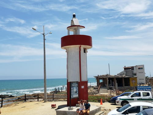
Date unknown (station established 1920s). Active; focal plane 14 m (46 ft); white light, 1.5 s on, 3.5 s off. 7 m (23 ft) round cylindrical concrete tower with gallery, painted white with red bands at the base and on the gallery. Walter Haro's 2019 photo is at right, Trabas has Porath's closeup photo, Elio Ruiz has a 2011 photo, Jorge Alarcón Cadena has a street view, and Google has a satellite view. Located at the village of Engabao, about 6.5 km (4 mi) northwest of El Pelado. Accessible by road. Site open, tower closed. ARLHS ECU-033; EC-1088; Admiralty G3048.8; NGA 0442.

Punta Engabao Light, El Pelado, September 2019
Google Maps photo by Walter Haro

Santa Elena Province Lighthouses
Santa Elena Province is located at the northern entrance to the Gulf of Guayaquil; it includes the beach resort cities of Salinas and La Libertad; the two resorts have a combined population of more than 200,000.

El Real
Date unknown. Active; focal plane 30 m (98 ft); white flash every 16 s. 12 m (39 ft) round concrete tower with a red stairway spiraling around the tower. Trabas has Porath's closeup photo and Google has a satellite view. This light replaced the nearby Chanduy light. Located on a headland near El Real, about 50 km (30 mi) southeast of Punta Santa Elena. Site open, tower closed. ARLHS ECU-038; EC-1087; Admiralty G3049.2; NGA 0438.
* Punta Ancón (Anconcito) (2)
2019 (station established around 1970). Active; focal plane 51 m (167 ft); white flash every 5 s. 8 m (26 ft) round concrete tower with lantern and gallery painted with red and white horizontal bands. A 2021 photo is available, Dayraaloa Vargas has a 2022 photo, Adan Velastegui has a closeup photo of this lighthouse under construction in Jun 2019, and Google has a satellite view. The earlier lighthouse was a square concrete tower painted with black and white horizontal bands. Trabas has Porath's closeup photo and a distant view was taken in March 2019. Located atop a steep promontory at Anconcito, about 15 km (9 mi) south of Santa Elena. Site open, tower closed. EC-1086; Admiralty G3049.4; NGA 0436.
* Chocolatera (Puntilla de Santa Elena) (3?)
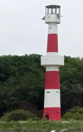
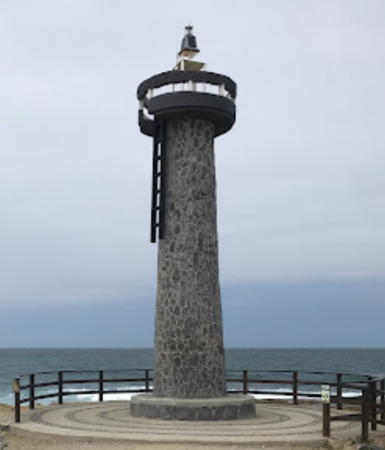
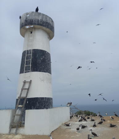
Around 2007 (station established around 1960). Active; focal plane 12 m (39 ft); two white flashes every 10 s. 6 m (20 ft) round solid concrete tower with gallery and an external ladder. Lighthouse unpainted with narrow gray horizontal bands. A photo by Oswaldo Velasquez is at right, a 2018 closeup photo is available, Trabas has Porath's closeup, Emiliano Enriquez has a 2016 street view, and Google has a satellite view. The lighthouse was formerly painted in a black and white checkerboard pattern. Adrian Cordero has a photo and Victor Mendivil also has a photo. Located at the tip of Punta Santa Elena, the westernmost point of the Ecudorian mainland, about 1750 m (1.1 mi) west of the Santa Elena lighthouse (next entry). Accessible by road. Site open, tower closed. ARLHS ECU-022; Admiralty G3051; NGA 0416.
* Punta Santa Elena (Salinas) (3?)
Date unknown (station established 1882). Active; focal plane 95 m (312 ft); five white flashes every 20 s. 12 m (39 ft) round tower mounted atop a 1-story building, with lantern and gallery. Building painted white with red trim, tower red, lantern white. Aventura Andrade's photo is at the top of this page, David Douglas has a 2021 photo, Trabas has Porath's closeup, Marco Carpio has a street view, and Google has a satellite view. Punta Santa Elena, the westernmost point of mainland Ecuador, is a very sharp promontory. The original lighthouse, a skeletal tower mounted atop a 2-story building, was listed with a focal plane of 143 m (470 ft); Estrada has photos (taken around 1922) on p. 302 of his book. Also pictured is the 23 m (74 ft) square skeletal tower that replaced the old lighthouse in 1928; it had a focal plane of 106 m (347 ft). The present lighthouse was built sometime after 1974. Located above the cape on the hill known as La Puntilla, about 3 km (2 mi) west of the yacht club light (next entry). Accessible by road; parking provided. Site open, tower closed. ARLHS ECU-006; EC-1082; Admiralty G3050; NGA 0412.

Chocolatera Light, Salinas, May 2014
Google Maps photo by Oswaldo Velasquez
* Salinas Yacht Club
1993. Active (privately maintained); focal plane 11 m (36 ft); white light, 2 s on, 4 s off. Approx. 10 m (33 ft) square pyramidal tower with a tall octagonal lantern, painted white; lantern roof is red. A photo is at right, another good photo is available, Rachel Rianne has a 2008 photo, Juan Jorge Arellano has a 2010 photo, Trabas has Porath's photo, David Sylva has a closeup street view, and Google has a satellite view. This tower carries the Barbier & Fenestre lantern and 3rd order Fresnel lens used at Isla Santa Clara from 1872 to 1921 (see above). Purchased from the Navy by the Guayaquil Yacht Club in 1956, the lantern and lens are on loan to the Salinas Yacht Club. Located on the yacht club's breakwater in Salinas. Site open, tower closed. Admiralty G3053.4; NGA 0425.6.
Hotel Girasol
Date unknown. Active; focal plane 40 m (131 ft); white flash every 5 s. Light mounted atop a 35 m (115 ft) hotel. In José Salazar's photo the light can be seen atop the 12-story hotel between the two high-rise towers. Google has a satellite view. Located on the waterfront of Salinas. Site open, tower closed. Site manager: Hotel Girasol. Admiralty G3053; NGA 0426.
Petrópolis (Punta San Lorenzo)
Date unknown. Active; focal plane 62 m (203 ft); four white flashes every 20 s. Light mounted atop a 54 m (177 ft) high-rise condo building. Google has a street view and a satellite view. Located on Punta San Lorenzo, at the east end of the Salinas waterfront. Site open, tower closed. Site manager: Alamar Condominiums. EC-1075; Admiralty G3052.3; NGA 0424.
* Ballenita (Punta Murciélago)
Date unknown. Active; focal plane 8 m (26 ft); two white flashes every 15 s. 6 m (20 ft) round cylindrical concrete tower with gallery painted white with red horizontal bands. Rob Curz has a photo, Trabas has Porath's photo, and Google has a satellite view. Located on the beach in front of a resort motel. Site open, tower closed. Site open, tower closed. EC-1058; Admiralty G3054.5; NGA 0433.

Salinas Yacht Club Light, Salinas, August 2007
Wikimedia Creative Commons photo by Ciencia1.com
Punta Centinela
2010. Active; focal plane 78 m (256 ft); two white flashes every 12 s. The light is on a short fiberglass tower atop the Torre Vigía del Mar condominium tower. The light is on the building at upper left in a drone view by Leonidas Villagran, Gorky Bonifaz has a sunset street view from the beach, and Google has a satellite view. This light replaced the former Capay lighthouse, which was located on the ridge behind the waterfront; that lighthouse apparently has been demolished. Located at Punta Blanca, about 20 km (13 mi) northwest of Salinas. Site open, tower closed. EC-1057; Admiralty G3055; NGA 0428.
Islote El Pelado (2)
Date unknown. Active; focal plane 27 m (89 ft); two white flashes every 8 s. 10 m (33 ft) triangular skeletal tower carrying an orange daymark. Ines Alvear has a view from the sea and another view from the sea is available, but the tower is hard to distinguish in Google's satellite view. The Spanish name means "Bare Island." NGA lusts a concrete tower. Located on a bare rocky island about 5 km (3 mi) offshore at the northern entrance to the Bahía Santa Elena. Site and tower closed (protected bird sanctuary). ARLHS ECU-021; Admiralty G3058; NGA 0408.

Manabí Province Lighthouses
Manabí Province covers a large area including about a third of Ecuador's coastline. It also includes Manta, a city of about 200,000 residents and Ecuador's largest port.

Isla Salango
Date unknown. Active; focal plane 141 m (463 ft); one long (1.5 s) white flash every 15 s. 7 m (23 ft) white concrete tower. No photo available but the small tower is seen in Google's indistinct satellite view. Despite its small size this is an important coastal light. Located atop a forested island just off a the prominent cape of Punta Salango, about 75 km (46 mi) north of Punta Santa Elena. Accessible only by boat. Site status unknown. Site manager: Parque Nacional Machalilla. ARLHS ECU-019; Admiralty G3060; NGA 0404.
Isla La Plata (4?)
Around 2000 (station established 1888). Active; focal plane 189 m (620 ft); white flash every 10 s. 28 m (92 ft) triangular skeletal tower, painted white. Trabas has Capt. Peter's photo and Google has an indistinct satellite view. There have been a series of lights on the island; the early ones were on masts, but skeletal towers have been in place since the 1930s. The Isla La Plata is an isolated, mountainous island about 16 km (10 mi) offshore and 25 km (15 mi) southwest of Cabo San Lorenzo. The island is a protected bird sanctuary and natural area. Located at the northwestern tip of the island. Site status unknown. ARLHS ECU-018; EC-1054; Admiralty G3064; NGA 0396.
* Cabo San Lorenzo (3?)
Date unknown (station established 1920s). Active; focal plane 130 m (427 ft); white flash every 10 s. 10 m (33 ft) round concrete tower with gallery, painted in an red and white checkerboard pattern. Doris Herrera has a 2019 photo, Ricardo Vera has a closeup street view, and Google has a distant satellite view. Tourist sites for Manta report that there is a "marvelous view from the lighthouse" toward the Isla de la Plata (about 16 km or 10 miles offshore). Located atop a steep bluff on the Cabo de San Lorenzo, a very prominent cape about 30 km (20 mi) southwest of Manta. Accessible by road (4WD recommended). Site open, tower closed. ARLHS ECU-007; EC-1052; Admiralty G3068; NGA 0392.
Punta Jomé
Date unknown. Active; focal plane 67 m (220 ft); white flash every 5 s. 7 m (23 ft) round concrete tower painted with black and white spiral stripes. Sherard Ortega has a closeup 2020 photo, Christian Meneses also has a photo, and Google has a satellite view. Located on a sharp cape about 10 km (6 mi) west of Manta. Site status unknown. Admiralty G3071; NGA 0388.
Manta Breakwater
Date unknown (station established 1872). Active; focal plane 20 m (66 ft); two white flashes every 10s. 14 m (46 ft) square concrete tower with gallery but no lantern, painted with red and white horizontal bands. Michael Boucher's closeup photo is at right, Trabas has Douglas Cameron's closeup photo, Víctor Vargas has a 2011 photo, and Bing has a satellite view. The history of this light is complex. There were at least three lighthouses built on land, and there may have been several on the breakwater beginning in the 1950s or 1960s. The present light probably dates from the 1990s. Located at the end of the east breakwater at Manta. Site status unknown, but the lighthouse can be seen from the waterfront. ARLHS ECU-008; EC-1045; Admiralty G3073; NGA 0380.

Breakwater Light, Manta
photo copyright Michael Boucher; used to permission
Punta Jaramijó (Punta Blanca) (2?)
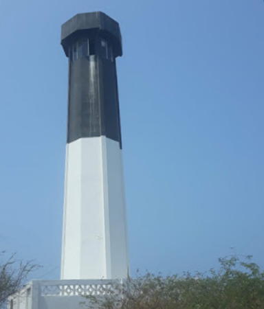
1960s. Active; focal plane 35 m (115 ft); three white flashes every 15 s. 17 m (56 ft) octagonal concrete tower painted with black and white horizontal bands. A photo is at right, Cristian Jimenez has a 2018 photo, Juan Carlos Gallegos Zambrano has a 2021 photo, Trabas has Michael Boucher's view, and Google has a street view and a satellite view. The light was listed initially with a focal plane of only 27 m (88 ft). Located on a headland on the east side of the entrance to the harbor of Manta. Site status unknown. ARLHS ECU-009; EC-1044; Admiralty G3076; NGA 0376.
Punta Belleca (2)
2022. Active; focal plane 41 m (135 ft); white light, 2 s on, 8 s off. 7 m (23 ft) concrete tower, painted in an orange and white pattern. No photo available but Google has a satellite view. The light was moved 175 m (190 yd) northeast in 2022. Bing has a distant satellite view of the former light. Located on a forested cape about 5 km (3 mi) southwest of Bahía de Caráquez and the mouth of the Río Chone. Site status unknown. ARLHS ECU-032; Admiralty G3085; NGA 0324.
* Bahía de Caráquez
Date unknown. Active; focal plane 9 m (30 ft); white flash every 10 s. 9 m (30 ft) square concrete post on a square concrete base, painted with red and white horizontal bands. Gustavo Fernández has a closeup 2022 photo and Google has a street view and a distant satellite view. Bahía de Caráquez is a beach resort town at the entrance to the estuary of the Río Chone. Located just off the beach near the tip of the peninsula on which the town is built. Site open, tower closed. Admiralty G3085.5; NGA 0326.
Cabo Pasado (4?)
Late 2000s (station established 1924). Active; focal plane 85 m (279 ft); white flash every 15 s. 9 m (30 ft) concrete tower, painted white with orange stripes. No photo available and the light is not clearly seen in Google's satellite view. The 2005 Derrotero pictures a small triangular skeletal tower. Located on a prominent cape about 65 km (40 mi) north of Manta. Site status unknown. ARLHS ECU-010; EC-1041; Admiralty G3090; NGA 0320.
Punta Ballena (2?)
Around 1970. Active; focal plane 40 m (131 ft); three white flashes, in a 2+1 pattern, every 15 s. Approx. 12 m (39 ft) white skeletal tower. Ramiro Proaño has a distant aerial photo, and Google has an indistnct satellite view. This light replaced an 8 m (26 ft) round concrete tower, painted white with a black stripe that zigzagged up the tower; the 2005 Derrotero has a small photo. Located on a prominent cape about 8 km (5 mi) west of Jama. NGA describes the original tower. Site status unknown. ARLHS ECU-011; EC-1039; Admiralty G3090.4; NGA 0316.
Faro Punta Jaramijo
Punta Jaramijo Light, Manta, May 2010
ex-Panoramio photo copyright mauriciops; used by permission
Punta Pedernales (Punta de los Frailes) (2)
Date unknown. Active; focal plane 35 m (115 ft); white light, 1.5 s on, 8.5 s off. Approx. 15 m (49 ft) triangular skeletal tower. This light replaced a 7 m (23 ft) square concrete tower painted with black and white horizontal bands. Fabian Mullo has a 2021 street view but Bing has only a fuzzy satellite view. Located on a headland about 8 km (5 mi) southwest of Pedernales. Site status unknown. ARLHS ECU-036; Admiralty G3091; NGA 0312.

Esmeraldas Province Lighthouses
Esmeraldas Province is the northernmost province of Ecuador; most of its coastline faces north rather than west. The capital city of Esmeraldas has about 175,000 residents and is an important port.

Cabo de San Francisco (Punta Tongora)
Around 1970. Active; focal plane 46 m (151 ft); three white flashes every 20 s. 7 m (23 ft) square solid concrete tower with gallery and an external ladder. Lighthouse painted in a black and white checkerboard pattern. A closeup photo is available and Bing has a distant satellite view. Located on a headland a few miles west of San Francisco. Site open, and nothing prevents visitors from climbing the tower. ARLHS ECU-016; EC-1037; Admiralty G3093; NGA 0308.
Punta Galera (3?)
Date unknown (station established 1922). Active; focal plane 36 m (118 ft); white flash every 10 s. 11 m (37 ft) round barbell-shaped tower colored with dark blue and white horizontal bands. Joan Ricardo Quiroz Riascos has a 2021 distant view and Google has a satellite view. This light replaced a round concrete tower, painted white with a red vertical stripe and a red band at the base; the 2005 Derrotero has a small aerial photo. Located on a headland about 100 km (60 mi) southwest of Esmeraldas and about 30 km (19 mi) north of Cabo de San Francisco. Site status unknown. ARLHS ECU-012; Admiralty G3094; NGA 0304.
* Punta Súa (Punta Atacames) (2)
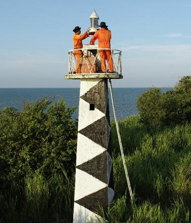
Around 2012. Active; focal plane 30 m (98 ft); one long (1.5 s) white flash every 15 s. Approx. 12 m (39 ft) triangular skeletal tower. Nestor Montiel has a 2019 photo, Efraín Ramírez Uribe has a very distant 2022 view, and Bing has a satellite view. The original light was an 8 m (26 ft) slender round concrete tower, painted in a red and white diamond checkerboard pattern; a photo is at right and Luis Guayanlema has a 2011 photo. Located on a cape about 30 km (19 mi) southwest of Esmeraldas. Site open, tower closed. ARLHS ECU-037; EC-1034; Admiralty G3095; NGA 0300.
* Punta Coquitos (Coquito)
Date unknown (station established by 1895). Active; focal plane 200 m (656 ft); three long (2 s) white flashes every 24 s. 13 m (43 ft) round concrete tower painted with red and white stripes in a spiral pattern. The 2005 Derrotero has a small photo and Google has a satellite view. The history of this station is quite unclear. The early lighthouses were at a low elevation on or near the tip of the point, but a 1966 light list describes a skeletal tower with a focal plane of 88 m (290 ft). The present light appears to date from around 1970. Located on heights on the southwest side of Esmeraldas. Site open, tower closed. ARLHS ECU-013; Admiralty G3096; NGA 0264.
[Esmeraldas South Harbor]
Date unknown. Active; focal plane 14 m (46 ft); green light occulting once every 15 s. 9 m (30 ft) concrete post extended with a short skeletal tower. Lighthouse painted white with a red horizontal band. Google has a satellite view. The building seen at the right in the photo is the Ecuadorian Navy's northern command center. This is one of several very similar lights in the harbor of Esmeraldas. Located at the end of the broad quay between the north and south harbors of Esmeraldas. Site and tower closed (military base). Admiralty G3096.3; NGA 0280.
Punta Verde (Río Verde, Ríoverde)
Around 1970. Active; focal plane 53 m (174 ft); white flash every 5 s. 8 m (26 ft) concrete tower, painted in a black and white checkered pattern. No photo available but Bing has an indistinct satellite view. Located on a promontory about 2.5 km (1.5 mi) northeast of Ríoverde. Site status unknown. EC-1014; Admiralty G3096.4; NGA 0260.

Punta Súa Light, Esmeraldas
Creative Commons photo by Toño (EA9CP)

 
San Pedro
Around 1960. Active; focal plane 43 m (141 ft); one long (1.5 s) white flash every 15 s. 41 m (135 ft) tapered square skeletal tower, painted orange. The tower is in the upper right corner of Ron Stachowiak's photo and Google has an indistinct satellite view. Located on Isla Santa Rosa, an island at the Colombian border. Accessible only by boat. Site status unknown. ARLHS ECU-040; EC-1005; Admiralty G3098; NGA 0236.

Information available on lost lighthouses:

Notable faux lighthouse:

Adjoining pages: North: Colombia Pacific | South: Northern Perú | West: Galápagos

Return to the Lighthouse Directory index | Ratings key

Posted July 2004. Checked and revised September 24, 2023. Lighthouses: 46. Site copyright 2023 Russ Rowlett and the University of North Carolina at Chapel Hill.