Lighthouses of East Ukraine: Sevastopol', Crimea

The Directory's pages for Crimea describe the lighthouses as they existed before the start of the current conflict between Ukraine and Russia. No changes will be made until there is a stable agreement that stops the fighting. Russian occupied territories in Ukraine are identified as East Ukraine.

Crimea is a peninsula on the north side of the Black Sea, attached to the mainland by a narrow isthmus. The territory has a long and complicated history. It was annexed to the Russian Empire in 1783. In the Soviet Union it was at first an autonomous republic and later an oblast (province) within the Russian Federation. In 1954 Crimea was transferred from the Russian Federation to the Ukrainian Soviet Socialist Republic. When the Soviet Union collapsed in 1991 Crimea became part of the newly-independent nation of Ukraine. However, Russia continued to occupy several important military bases in the territory, including the home port of the Black Sea Fleet in Sevastopol'.

In March 2014 Russia annexed Crimea, leaving the Ukrainian coast in two sections: the Bight of Odessa in the west and the northwestern side of the Sea of Azov in the east. The annexation of Crimea has not been accepted by Ukraine or recognized internationally. Important note: The Lighthouse Directory's mission and task is to describe lighthouses without offering any comment or opinion on politics or international relations. Our descriptions are always of the actual situation whatever it may be. The Crimean lighthouses are described here as Russian because de facto Russia possesses and operates them.

The members of the Russian Federation are called federal subjects (sub'yekty federatsii, Субъекты федерации). Sevastopol' was admitted to the Russian Federation as a federal city (gorod federalnogo znacheniya, город федерального значения): the same status held by Moscow and by St. Petersburg. The rest of Crimea was annexed as the Republic of Crimea (Respublika Krym, Республика Крым). This brought the number of federal subjects to 85.

This page includes lighthouses of the City of Sevastopol' region in the southwestrn section of the Crimean Peninsula.

Most of the lighthouses of Crimea were destroyed or heavily damaged during World War II (or the Great Patriotic War, as it is called in Russia). German troops invaded in 1941 and captured all of the peninsula except for some of the highest mountains; Sevastopol' surrendered in July 1942 after a bitter nine-month siege. Soviet troops drove the Germans out in equally heavy fighting in 1944.

The Russian word for a lighthouse is mayak (маяк); ostrov is an island, poluostrov is a peninsula, kosa is a sandy spit, rif is a reef, mys is a cape, bukhta is a bay, zaliv is a larger bay or gulf, proliv is a strait, reka is a river, and gavan' is a harbor.

ARLHS numbers are from the ARLHS World List of Lights. Admiralty numbers are from volume N of the Admiralty List of Lights & Fog Signals. U.S. NGA List numbers are from Publication 113.
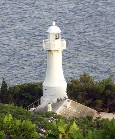
Sarych Light
Sarych Light, Foros, July 2008
unattributed photo from Geocaching.su
General Sources
Derzhhidrohrafiyu - Lighthouses
Photos and historical information on the Ukrainian State Hydrography web site. (Ukraine continues to consider the Crimean lighthouses as Ukrainian, and there is no comparable Russian reference.)
Online List of Lights - Ukraine
Photos by various photographers posted by Alexander Trabas. (Trabas follows the Admiralty in retaining Crimean lights under Ukraine.)
Lighthouses in Ukraine
The ARLHS Ukraine listing; photos contributed by Ukrainian amateur radio operators are available for many of the lighthouses. (ARLHS maintains the Crimean lighthouses with the UKR designation.)
Lighthouses in Crimea
Photos by various photographers available from Wikimedia. (Wikimedia files photos of Crimean lighthouses under both Ukraine and Russia.)
World of Lighthouses - Crimea
Photos by various photographers available from Lightphotos.net.
Russische Leuchttürme auf historischen Postkarten
Historic postcard images posted by Klaus Huelse (Crimean lighthouses are in a separate group a little more than halfway down the page).
Navionics Charts
Navigation chart for Crimea.
South Coast Lighthouses
Sarych (Mys Sarych)
1911. Active; focal plane 38 m (125 ft); white light, 3 s on, 3 s off. Approx. 15 m (49 ft) round tapered cast iron tower with lantern and gallery, painted white. 1-1/2 story keeper's house painted white with a green roof. A photo appears at the top of this page, Zhuzhik Furman has a 2017 photo, Lightphotos.net has a photo, and Google has a satellite view. The height of the tower is listed as 10.5 m (35 ft) by NGA, but clearly the lighthouse is taller than that. Located at the southernmost point of the Crimean peninsula, the lighthouse was abandoned during the early Soviet period (1920s) because of its remote location. Its remoteness was an asset during World War II, when German troops never occupied the area. Located on Mys (Cape) Sarych, about 40 km (25 mi) southeast of Sevastopol'. Site and tower closed; this was one of several light stations occupied by Russian Navy personnel during Ukraine's administration of Crimea. ARLHS UKR-015; Admiralty N5314; NGA 18336.
Balaklavskiy Range Rear
Date unknown. Active; focal plane 81 m (266 ft); continuous red light. Approx. 12 m (39 ft) square skeletal tower, painted black. The tower carries a slatted daymark painted white with a black vertical stripe. Yahor Narkevich has a sea view from the harbor, Svetlana Tyumentseva has a distant view and Google has an indistinct satellite view. This is an approach range for Balaklava Bay. The front light, on a much shorter skeletal tower, is on the east side of the entrance to the bay. Balaklava has a long history; its deep and easily defended harbor made it an important base for the Greek, Byzantine, Genoese, and Ottoman empires before Crimea was conquered by Russia. During the Crimean War (1854) it was the site of the suicidal Charge of the Light Brigade memorialized in a famous poem by Tennyson. Located atop a steep ridge inside the entrance to Balaklava Bay, a fjord about 15 km (9 mi) due south of Sevastopol'. Site status unknown. ARLHS UKR-061; Admiralty N5312.1.
Balaklavskiy West Range Front
Date unknown. Active; focal plane about 50 m (165 ft); yellow light, pattern unknown. Approx. 15 m (49 ft) quare skeletal tower, painted black and standing in front of a 1-story equipment shelter. The tower carries a slatted daymark painted white with a black vertical stripe. A photo shows the range lights on the left; the rear light is on a concrete wall. This light is also seen at lower left in the sea view by Yahor Narkevich and Google has an indistinct satellite view. This range guides outbound ships approaching the mouth of the bay. Located on the west side of the entrance to Balaklava Bay. Site status unknown. Admiralty N5312.05.
Mys Balaklavskiy
Date unknown. Active; focal plane 62.5 m (205 ft); white flash every 5 s. Approx. 12 m (39 ft) square cylindrical skeletal tower. Oleksandr Nigmatulin has the street view seen at right and Google has an indistinct satellite view. Located on a very steep promontory on the west side of the entrance to Balaklava Bay. Practically inaccessible. Admiralty N5311.
Kayabash (Kayabashi)
Date unknown. Active; focal plane 301 m (988 ft); white flash every 4 s. 11 m (36 ft) square cylindrical skeletal tower, painted black. The tower carries a slatted daymark painted white with a black vertical stripe. Alexander Talyzin has a distant view and Google has an indistinct satellite view. Located atop a spectacular cliff about 5 km (3 mi) east of Mys Fiolent. Site status unknown. ARLHS UKR-067; Admiralty N5310; NGA 18326.

Mys Balaklavskiy Light, Balaklava Bay, August 2016
Google Maps street view by Oleksandr Nigmatulin
Mys Fiolent (1)
Date unknown. Inactive. Approx. 5 m (17 ft) round concrete tower. Mikhail Sev has a closeup photo and Google has a satellite view. Located on a high promontory about 15 km (9 mi) southeast of Mys Khersonesskiy. Site status unknown.
Mys Fiolent (3)
Date unknown. Active; focal plane 168 m (551 ft); red flash every 3 s. 8 m (26 ft) round cylindrical tower with gallery and a two triangular daymarks, point down, on the upper part of the tower. Lighthouse painted white with a black vertical stripe on the cones. A distant view is available and Google has a satellite view. NGA lists the earlier light, a small skeletal tower. Located on a high promontory about 15 km (9 mi) southeast of Mys Khersonesskiy. Site status unknown. ARLHS UKR-062; Admiralty N5309; NGA 18324.
** Khersonesskiy (Mys Khersonesskiy, Chersones, Sevastopol') (4)
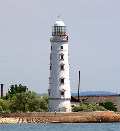
1951 (station established 1816). Active; focal plane 34 m (112 ft); white light, 3 s on, 3 s off, 3 s on, 3 s off, 3 s on, 6 s off, 3 s on, 3 s off, 6 s on, 3 s off, 6 s on, 18 s off. 36 m (118 ft) round stone tower with lantern and gallery, painted white. A 4th (?) order Fresnel lens is in use. Dmitriy Metelkin's photo is at right, Daria Egorova has a 2021 photo, Andrey Sitnoff has a 2016 photo, ARLHS has a photo, Wikimedia has Stas Klevtsov's distant view, Huelse has a historic postcard view, Alexey Boldyrev has a 2017 street view, and Google has a good satellite view. This historic lighthouse stands on the southwest corner of the Crimean peninsula. The original lighthouse was a conical stone tower. It was replaced in 1929 by a lighthouse built from the same plans as the Tarkhankut Light (see below). Almost completely destroyed during World War II, it was replaced by a wood tripod tower until a copy of the 1929 lighthouse could be built. The tower is greatly endangered by rising sea level, and a stone berm and semicircular sea wall have been built to protect it. The unusual flash pattern, the Morse code "SW" for Sevastopol', is a traditional welcome-home for Russian sailors. In August 2008 a diplomatic spat arose after Ukrainian officials tried to seize equipment at the lighthouse and were instead detained by Russian Navy staff. Located at the tip of the peninsula about 15 km (9 mi) west of Sevastopol'. Site open, tower apparently open for climbing but no schedule is available. ARLHS UKR-022; Admiralty N5308; NGA 18320.
Khersonesskiy Light
Khersonesskiy Light, Sevastopol', August 2010
photo copyright Dimitriy Metelkin; used by permission

Sevastopol' Harbor Lighthouses
Sevastopol' Bay is an estuary at the mouth of the Chorna River. The estuary is about 8 km (5 mi) long, providing a beautiful protected harbor that is the traditional home of Russia's Black Sea Fleet. There are additional harbor basins in shorter estuaries along the north coast of the Khersonesskiy Peninsula, southwest of the main harbor. The city itself has a population of about 510,000.

Kamyshovaya Bay (Sevastopol' Fishing Harbor) Range Front
Date unknown. Active; focal plane unknown; red light, 2 s on, 2 s off. Approx. 20 m (66 ft) round cylindrical concrete tower with lantern and gallery. Lighthouse painted white with a red vertical stripe on the range line, lantern and gallery painted red. Yura Vlasov has a photo, Victoria Baglay has a street view, and Google has a good satellite view. Kamyshovaya Bay is a harbor about 4 km (2.5 mi) west of Cape Khersonesskiy. Located at the south end of the harbor. Site status unknown. ARLHS UKR-064; Admiralty N5304.7; NGA 18280.
Kamyshovaya Bay (Sevastopol' Fishing Harbor) Range Rear
Date unknown. Active; focal plane unknown; red light, 2 s on, 2 s off. Approx. 20 m (66 ft) round cylindrical concrete tower with lantern and gallery. Lighthouse painted white with a vertical stripe on the range line, lantern and gallery painted black. Lightphotos.net has a photo and Google has a good satellite view. Located about 250 m (800 ft) south southeast of the front light. Site status unknown. ARLHS UKR-065; Admiralty N5304.71; NGA 18281.
* Kruglaya Bay East
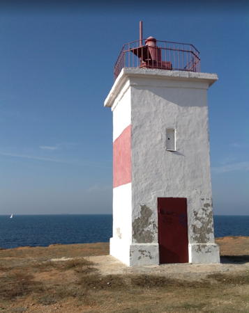
Date unknown. Active; focal plane 15 m (49 ft); yellow flash every 3 s. 6 m (20 ft) square cylindrical concrete tower painted white with a red horizontal band. Andrey Vorob'yev has a 2012 photo (also seen at right), Lightphotos.net has a photo and Google has a satellite view. Located on the east side of the entrance to Kruglaya Bay. Site open, tower closed. ARLHS UKR-072; Admiralty N5304.6.
Kadetskyi
2019. Active; focal plane 16 m (52 ft); continuous white light. 8 m (26 ft) octagonal tower, gray with a red horizontal band. No photo available but Google has a satellite view. The Admiralty announced this light in Decemeber 2019. Located on a point of land on the west side of Strelets Bay. Site status unknown. Admiralty N5303.9.

Kruglaya Bay Light, Sevastopol', October 2012
Google Maps photo by Andrey Vorob'yev
* Streletskiy Range Front
Date unknown. Active; focal plane 39 m (128 ft); green flash every 2.6 s. Approx. 20 m (66 ft) square cylindrical skeletal tower, painted red. The tower also carries a large slatted daymark. Sergey Genovsky has a panoramic view (the tower is to the left of the apartments) but the tower is hard to see in Google's satellite view. This range guides vessels entering Strelets Bay, a narrow harbor west of Sevastopol'. Located on the west side of the harbor, near the south end. Site status unknown but the lighthouse can be seen from a nearby street. ARLHS UKR-081; Admiralty N5304.
* Streletskiy Range Rear
Date unknown. Active; focal plane 59 m (194 ft); green flash every 2.6 s. Approx. 20 m (66 ft) square cylindrical skeletal tower, painted red. The tower also carries a large slatted daymark. No photo available but the shadow of the tower is visible in Google's satellite view. Located about 250 m (800 ft) south of the front light. Site status unknown but the lighthouse can be seen from a nearby street. ARLHS UKR-082; Admiralty N5304.1.
Karantinnyy Bay Entrance Range Rear
Date unknown. Active; focal plane unknown; continuous red light. Approx. 12 m (39 ft) round tower painted with red and white horizontal bands. Yahor Narkevich has a 2019 drone view and Google has a satellite view.This range guides vessels entering Karantinnyy Bay, a harbor just outside the south breakwater of Sevastopol' Bay. The front light is on a post. Site status unknown. Admiralty N5303.51; NGA 18279.
* Lukul'skiy (Pukupp'skiy) Range Front
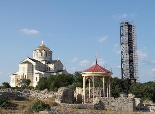
Date unknown. Active; focal plane unknown; continuous red light. Approx. 20 m (66 ft) square cylindrical skeletal tower, painted black. A 2017 photo is at right, Lera Melnikova has a photo, and Google has a photo, a street view by Yuriy Filatov, and a satellite view. This is an approach range for vessels arriving in Sevastopol' from the north. The light stands close to St. Vladimir's Cathedral, built in honor of the Kievan prince Vladimir who converted to Christianity here in 988 CE. Located on a headland about 1 km (0.6 mi) southwest of the entrance to Sevastopol' Bay. Site open, tower closed. ARLHS UKR-073; Admiralty N5303.

St. Vladimir's Cathedral and Lukul'skiy Front Light, Sevastopol', July 2017
Google Maps photo by Natali NA
* Lukul'skiy (Pukupp'skiy) Range Rear
Date unknown. Active; focal plane unknown; green light occulting once every 2.3 s. Approx. 20 m (66 ft) square skeletal tower, painted black. A distant drone view is available and Google has a satellite view. Located about 3 km (1.8 mi) south of the front light. Site open, tower closed. ARLHS UKR-074; Admiralty N5303.1.
* Inkermanskiy (Sevastopol' South) Range Front (2)
1946 (station established 1821). Active; focal plane 91 m (299 ft); continuous red light. 10 m (33 ft) square cylindrical stone tower with lantern and gallery, centered on a square stone keeper's house. Lighthouse painted white. Lightphotos.net has a closeup photo, the Derzhhidrohrafiyu has a small photo, and Google has a satellite view. This range shines a powerful pair of lights, white above red, down the full length of Sevastopol' Bay. The original lighthouse was repaired after being damaged during the Crimean War (1853-56), but it was completely destroyed during World War II. The present lighthouse is a replica of the original. Inkerman is a city at the east end of Sevastopol' Bay; it was the site of a major battle of the Crimean War in November 1854. Located on the heights on the north side of Sevastopol' Bay, northwest of the city. Site open, tower closed. ARLHS UKR-063; Admiralty N5302; NGA 18272.
Inkermanskiy (Sevastopol' South) Range Rear (2)
1946 (station established 1821). Active; focal plane 196 m (643 ft); continuous white light. 10 m (33 ft) square stone building, painted white. A photo is at right, Lightphotos.net has a photo, and Google has a satellite view. The entire staff of this lighthouse, 28 men, were killed by a direct hit in a German air raid during World War II. The present lighthouse is a copy of the original. Located on a mountaintop behind the city of Sevastopol' Bay, about 3 km (1.8 mi) east of the front light. Site status unknown. ARLHS UKR-031; Admiralty N5302.1; NGA 18273.


Inkermanskiy Range Rear Light, Sevastopol'
anonymous Wikimapia Creative Commons photo

Sevastopol' Severnovo Mola (North Mole) (2?)
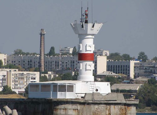
Date unknown (station established 1914). Active; focal plane unknown; quick-flashing red light. Round cylindrical tower with gallery, mounted on an octagonal base. Lighthouse painted white with one narrow red horizontal band. Trabas has the closeup by Douglas Cameron seen at right, Wayne Hopkins has a 2008 closeup, a 2018 photo is available, and the tower can be seen in a Google satellite view. The entrance to the harbor of Sevastopol' is flanked by two breakwater moles, but only the north mole has a light. This light is at the end of the north mole, which extends from the Konstantinovskiy fort on the north shore. Site and tower closed. ARLHS UKR-079; Admiralty N5302.7.

West Coast Lighthouses
Lyubimovka
Date unknown. Active; focal plane 64 m (210 ft); white flash every 5 s. Approx. 12 m (39 ft) square cylindrical skeletal tower with gallery, painted black. The tower carries a slatted daymark painted white with a black vertical stripe. No photo available but Google has a satellite view . Located on a steep bluff about 8 km (5 mi) north of the Sevastopol' entrance. Site status unknown. ARLHS UKR-075; Admiralty N5300; NGA 18270.
Mys Margopulo (Marhupolo)
Date unknown. Active; focal plane unknown; red flash every 3 s. Approx. 10 m (33 ft) triangular skeletal tower mounted atop a drum-shaped round tower. A photo is available, Dmitry Palamarchuk has a closeup, and Google has a satellite view. Located on a steep bluff about 15 km (9 mi) north of the Sevastopol' entrance. Site status unknown. Admiralty N5293; NGA 18269.
Sevastopol North Mole Light
Sevastopol' North Mole Light, Sevastopol'
photo copyright Douglas Cameron; used by permission
* Lukull (Mys Lukull, Lukullskiy)
Date unknown. Active; focal plane 41 m (135 ft); white flash every 3 s. 16 m (52 ft) skeletal tower, mounted on a concrete base. Lighthouse painted red. The seaward side carries a large slatted daymark, painted white with a black vertical stripe. A very distant street view is available and Google has a satellite view. Located on Mys (Cape) Lukull, a promontory about 3 km (2 mi) northwest of Adriivka and 25 km (15 mi) north of Sevastopol'. Site open, tower closed. ARLHS UKR-135; Admiralty N5288; NGA 18268.

Information available on lost lighthouses:

Notable faux lighthouses:

Adjoining pages: North: Western Crimea | East: Eastern Crimea

Return to the Lighthouse Directory index | Ratings key

Posted February 19, 2007. Checked and revised August 24, 2021. Lighthouses: 23. Site copyright 2021 Russ Rowlett and the University of North Carolina at Chapel Hill.