Lighthouses of East Ukraine: Eastern Crimea

The Directory's pages for Crimea describe the lighthouses as they existed before the start of the current conflict between Ukraine and Russia. No changes will be made until there is a stable agreement that stops the fighting. Russian occupied territories in Ukraine are identified as East Ukraine.

Crimea is a peninsula on the north side of the Black Sea, attached to the mainland by a narrow isthmus. The territory has a long and complicated history. It was annexed to the Russian Empire in 1783. In the Soviet Union it was at first an autonomous republic and later an oblast (province) within the Russian Federation. In 1954 Crimea was transferred from the Russian Federation to the Ukrainian Soviet Socialist Republic. When the Soviet Union collapsed in 1991 Crimea became part of the newly-independent nation of Ukraine. However, Russia continued to occupy several important military bases in the territory including the home port of the Black Sea Fleet in Sevastopol'.

In March 2014 Russia annexed Crimea, leaving the Ukrainian coast in two sections: the Bight of Odessa in the west and the northwestern side of the Sea of Azov in the east. The annexation of Crimea has not been accepted by Ukraine or recognized internationally. Important note: The Lighthouse Directory's mission and task is to describe lighthouses without offering any comment or opinion on politics or international relations. Our descriptions are always of the actual situation, whatever it may be. The Crimean lighthouses are described here as Russian because de facto Russia possesses and operates them.

The members of the Russian Federation are called federal subjects (sub'yekty federatsii, Субъекты федерации). Sevastopol' was admitted to the Russian Federation as a federal city (gorod federalnogo znacheniya, город федерального значения): the same status held by Moscow and by St. Petersburg. The rest of Crimea was annexed as the Republic of Crimea (Respublika Krym, Республика Крым). This brought the number of federal subjects to 85. The Republic of Crimea is divided into 14 districts (raions, районы) and 11 cities (goroda, города).

This page includes lighthouses of eastern Crimea from the Kerch Strait through the city of Yalta.

Most of the lighthouses of Crimea were destroyed or heavily damaged during World War II (or the Great Patriotic War, as it is called in Russia). German troops invaded in 1941 and captured all of the peninsula except for some of the highest mountains; Sevastopol' surrendered in July 1942 after a bitter nine-month siege. Soviet troops drove the Germans out in equally heavy fighting in 1944.

The Russian word for a lighthouse is mayak (маяк); ostrov is an island, poluostrov is a peninsula, kosa is a sandy spit, rif is a reef, mys is a cape, bukhta is a bay, zaliv is a larger bay or gulf, proliv is a strait, reka is a river, and gavan' is a harbor.

Russian lighthouses are owned by the Russian Navy and maintained by the Office of Navigation and Oceanography (Управление навигации и океанографии).

ARLHS numbers are from the ARLHS World List of Lights. Admiralty numbers are from volume N of the Admiralty List of Lights & Fog Signals. U.S. NGA List numbers are from Publication 113.


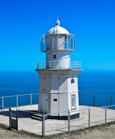
Kyz-Aul Light, Zavitne
Derzhhidrohrafiyu photo
General Sources
Derzhhidrohrafiyu - Lighthouses
Photos and historical information on the Ukrainian State Hydrography web site. (Ukraine continues to consider the Crimean lighthouses as Ukrainian and there is no comparable Russian reference.)
Online List of Lights - Ukraine
Photos by various photographers posted by Alexander Trabas. (Trabas follows the Admiralty in retaining Crimean lights under Ukraine.)
Lighthouses in Ukraine
The ARLHS Ukraine listing; photos contributed by Ukrainian amateur radio operators are available for many of the lighthouses. (ARLHS maintains the Crimean lighthouses with the UKR designation.)
Lighthouses in Crimea
Photos by various photographers available from Wikimedia. (Wikimedia files photos of Crimean lighthouses under both Ukraine and Russia.)
World of Lighthouses - Crimea
Photos by various photographers available from Lightphotos.net.
Russische Leuchttürme auf historischen Postkarten
Historic postcard images posted by Klaus Huelse (Crimean lighthouses are in a separate group a little more than halfway down the page).
Navionics Charts
Navigation chart for Crimea.
 

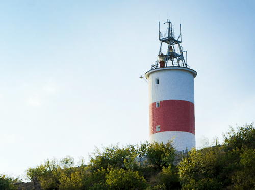
Rybacy Light, Rybacy
Derzhhidrohrafiyu photo
 

West Side Kerch Strait Lighthouses

The Kerch Strait is the narrow passage connecting the Sea of Azov to the Black Sea. From 1991 to 2014 the strait formed part of the border between Ukraine and Russia but since Russia's annexation of Crimea in 2014 the strait is entirely Russian. The strait is about 65 km (40 mi) long and narrows to about 4500 m (2.8 mi) wide at its narrowest point. In its natural condition the strait is too shallow for modern vessels, but a dredged channel called the Kerch-Yenikale Canal allows ships with a draft of up to 8 m (26 ft) to navigate the strait. Russia has built the Crimean Bridge to connect Crimea to the Russian mainland; the road portion of the bridge opened in May 2018 and the rail portion in December 2019. At 18.1 km (11.2 mi) it is the longest bridge in both Russia and Europe. Lighthouses on the east side of the strait are described on the Russia: Eastern Kerch Strait and Sea of Azov page.

Lenine District North Coast Lighthouse
* Yenikal'skiy (Cape Fonar) (2)
1861 (station established 1820). Active; focal plane 123 m (404 ft); three white flashes every 14 s. 27 m (89 ft) round white tower with lantern and gallery, painted white. 1-story keeper's house and other light station buildings. A photo is at right, Lightphotos.net has a closeup and a view from the sea, Roman Zymovets has a good 2011 photo, Alex Kuledin has a street view, and Google has a satellite view. Cape Fonar is the easternmost point of the Crimean peninsula, and it forms the west side of the northern entrance to the Kerch Strait from the Sea of Azov. The name fonar' (фонарь) means "lantern" in Russian. Located high above the strait in the city of Krym. Site open, tower closed. ARLHS UKR-009; Admiralty N5422; NGA 18560.

Kerch City Lighthouses
Kerch is a municipality that extends along the northern 2/3 of the west coast of the Kerch Strait. Port Krym is at the north end of the city and Port Kerch is near the southern end. The total population of the municipality is about 150,000.

Port Krym Range Front
Date unknown. Active; focal plane 13 m (43 ft); continuous green light. 15 m (49 ft) square skeletal tower with lantern carrying a rectangular slatted daymark; entire tower and daymark painted orange with a black vertical stripe. Lightphotos.net has a photo and Google has a satellite view. Ferries cross the Strait from Port Krym to Port Kavkaz. Located behind the ferry port. Site status unknown. Admiralty N5423.
Port Krym Range Rear
Date unknown. Active; focal plane 18 m (59 ft); continuous green light. 8 m (26 ft) square skeletal tower with lantern carrying a rectangular slatted daymark; entire tower and daymark painted orange with a black vertical stripe. Lightphotos.net has a photo and Google has a satellite view. Located about 300 m (330 yd) northwest of the front light. Site status unknown. Admiralty N5423.1.
Port Kerch (Shyrokyi Mole) Range Front
Date unknown. Active; focal plane 12 m (39 ft); red flash every 2 s. Approx. 9 m (30 ft) square cylindrical skeletal tower, painted black. The tower carries a slatted daymark painted white with a red vertical stripe. No photo available but Google has a satellite view. This is the entrance range for Port Kerch. Located at the end of one of the main piers of Port Kerch. Site and tower closed. ARLHS UKR-115; Admiralty N5374.4; NGA 18499.1.
Yenikal'skiy Light
Yenikal'skiy Light, Krym, August 2007
Wikimedia Creative Commons photo by Solundir
Port Kerch (Shyrokyi Mole) Range Middle
Date unknown. Active; focal plane 18 m (59 ft); continuous red light. Approx. 15 m (49 ft) square cylindrical skeletal tower, painted black. The tower carries a slatted daymark painted white with a red vertical stripe. No photo available but Google has a satellite view. Located near the base of the same pier that carries the front light. Site and tower closed. ARLHS UKR-116; Admiralty N5374.41; NGA 18499.2.
Port Kerch (Shyrokyi Mole) Range Rear
Date unknown. Active; focal plane 50 m (164 ft); continuous red light. Approx. 26 m (85 ft) square cylindrical skeletal tower, painted black. The tower carries a slatted daymark painted white with a red vertical stripe. No photo available but Google has a satellite view. Located in a residential neighborhood of Port Kerch about 1.5 km (1 mi) northwest of the front and middle lights. Site open, tower closed. Admiralty N5374.42; NGA 18499.3.
Genuez'kyy
Date unknown. Active; focal plane about 9 m (30 ft); red flash every 2.5 s. 9 m (30 ft) round concrete post centered on a square 1-story equipment shelter. No photo available but Bing has a satellite view. Located at the end of a mostly-submerged breakwater sheltering the south side of Kerch harbor. Accessible only by boat. Site open, tower closed. Admiralty N5375; NGA 18520.
Kerch Fishing Port Range Front
Date unknown. Active; focal plane 32 m (105 ft); continuous red light. Approx. 28 m (89 ft) square tapered white skeletal tower. No photo available but Google has a satellite view. The "fishing" port is now an industrial terminal. Located on the waterfront of the port, a smaller basin on the south side of Port Kerch. Site and tower closed. Admiralty N5374.7.
Kerch Fishing Port Range Rear
Date unknown. Active; focal plane 42 m (138 ft); continuous red light. Approx. 35 m (115 ft) square tapered white skeletal tower. No photo available but Google has a satellite view. Located about 250 m (820 ft) west southwest of the front light. Admiralty N5374.71.
Nijni Pavlovskiy (Pavlovsky Range Front) (2)
1909 (station established 1863). Active; focal plane 65 m (213 ft); continuous red light. 17 m (56 ft) octagonal stone tower, painted white with a red vertical stripe on the range line. A photo is at right, Lightphotos.net has a photo and Google has a satellite view. The original lighthouse had a focal plane of 22 m (72 ft). Located about 500 m (0.3 mi) from the waterfront in Arsyncevo, about 6 km (3.5 mi) south of Kerch city. Site status unknown. ARLHS UKR-025; Admiralty N5370; NGA 18448.

Nijni Pavlovskiy Light, Arsyncevo
Derzhhidrohrafiyu photo
Verkhni Pavlovskiy (Pavlovsky Range Rear) (2)
1907 (station established 1883). Active; focal plane 105 m (344 ft); continuous red light. 15 m (49 ft) round cylindrical metal tower, painted black; the lower portion of the tower is supported by square skeletal bracing. Lightphotos.net has a photo and Google has an indistinct satellite view. The range, which guides ships northbound through the strait, replaced a single lighthouse built in 1863. The first rear light was on a wood tower. Located 640 m (0.4 mi) north of the front light. Site status unknown. Admiralty N5370.1; NGA 18452.
* Kamysh-Burunskiy (Range Front) (1)
1873. Inactive since 1909. Approx. 8 m (26 ft) octagonal stone rising from the front of a 1-story stone keeper's house. Building painted white. The Derzhhidrohrafiyu has a photo (also seen at right). Located in front of the active lighthouse (next entry).
* Kamysh-Burunskiy (Range Front) (2)
1909 (station established 1873). Active; focal plane 52 m (171 ft); continuous red light. 32 m (105 ft) round cylindrical concrete tower, painted white. The Derzhhidrohrafiyu has a photo (also seen at right) and Google has a satellite view. This range guides southbound vessels on a long west southwest reach past Port Kerch and under the Crimean Bridge. Located on Mayaka Ulitsa (Lighthouse Street) in Kamysh-Burun. Site apparently open, tower closed. ARLHS UKR-021; Admiralty N5374; NGA 18492.

Lenine District East Coast Lighthouses
Churbashskiy (Kamysh-Burunskiy Range Rear) (1)
1909. Inactive since 1988. Approx. 13 m (43 ft) octagonal cylindrical stone tower, rising from a keeper's house. No photo available but Google has a satellite view of the station. The lighthouse was replaced by a taller tower (next entry). Located about 2.5 km (1.5 mi) southwest of Arsyncevo. Site status unknown. ARLHS UKR-110.

Old and new Kamysh-Burunskiy Range Front Lights, Kamysh-Burun
Derzhhidrohrafiyu photo
Churbashskiy (Kamysh-Burunskiy Range Rear) (2)
1988 (station established 1909). Active; focal plane 126 m (413 ft); continuous white light. 31 m (102 ft) square cylindrical skeletal tower. The tower carries a large slatted daymark painted black with a white vertical stripe on the range line (NGA says black with a red stripe). The Derzhhidrohrafiyu has a photo and Google has a satellite view. There is a large group of buildings adjoining the lighthouse, but we don't know the nature of the installation. Southbound ships follow this range west southwest before turning southwest on the Bukhta Kamysh-Burunskiy Range. Located about 2.5 km (1.5 mi) southwest of Arsyncevo and 9.3 km (5.8 mi) west southwest of the front light. Site status unknown. ARLHS UKR-110; Admiralty N5374.1; NGA 18496.
* Burunsky (Bukhta Kamysh-Burunskiy) Range Front
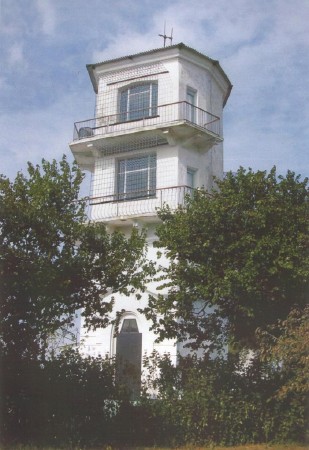
1909. Active; focal plane 30 m (98 ft); continuous green light,visible only on the range line to the northeast. 16 m (52 ft) 4-story octagonal cylindrical stone tower with gallery; it appears that the light was shown through a window on the top floor, but it is mounted now on the gallery rail. Lighthouse painted white. A photo is at right, Lightphotos.net has a closeup photo, Aleks Kuledin has a street view, and Google has a satellite view. The two Burunsky lighthouses were substantially rebuilt in 1954 to repair the heavy damage of World War II. The range guides southbound ships on a short southwest reach before turning southward. Located about 1.5 km (1 mi) northeast of the rear light on the north side of Heroevskoe. Site apparently open, tower closed. ARLHS UKR-006; Admiralty N5372; NGA 18476.
* Burunsky (Bukhta Kamysh-Burunskiy) Range Rear
1909. Active; focal plane 53 m (174 ft); continuous light, green on the range line to the northeast and red on a second line to the southeast. 11 m (36 ft) 3-story octagonal cylindrical stone tower with gallery; it appears that the lights were shown through different windows on the top floor, but at least one may be mounted now on the gallery rail. Lighthouse painted white. Lightphotos.net has a photo, Aleks Kuledin has a street view, and Google has a satellite view. The range guides southbound ships on a reach off Kamysh-Burun. Located about 1.5 km (1 mi) southwest of the front light and 2 km (1.25 mi) west of Heroevskoe. Site apparently open, tower closed. ARLHS UKR-007; Admiralty N5372.1; NGA 18480.
Takil (Mys Takil, Takilskiy) (2)
Date unknown. Active; focal plane 101 m (331 ft) (?); white flash every 4 s. Approx. 20 m (66 ft) square steel skeletal tower, painted with red and white horizontal bands. Anton Nadolny has a distant view and Google has a satellite view of the station. Mys Takil is the cape on the west side of the southern entrance to Kerch Strait. ARLHS has a photo of the earlier light, which was shorter, so probably the focal plane has increased. Located on a bluff above the point of the cape. Site status unknown. ARLHS UKR-083; Admiralty N5361; NGA 18412.
Burunsky Range Front Light
Burunsky Range Front Light, Heroevskoe
Derzhhidrohrafiyu photo

South Coast (Black Sea) Lighthouses

Lenine District South Coast Lighthouses
The Lenine District includes the eastern peninsula of Crimea, bordering the Sea of Azov to the north, the Kerch Strait to the east, and the Black Sea to the south. It surrounds the city of Kerch.
* Kyz-Aul (Mys Kyz-Aul, Kyz-Aulskiy)
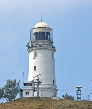
1876. Active; focal plane 62 m (204 ft); flash every 6 s, white, red, or green depending on direction. 28 m (92 ft) octagonal masonry tower with lantern and gallery. Tower painted with black and white vertical stripes; lantern painted white. 1-story masonry keeper's house and other light station buildings. A photo is at the top of this page, Lightphotos.net has Sergey Dolya's photo, Alexandr Deev has a distant view, Oleg Okorokov has a distant street view, Huelse has a historic postcard view, and Bing has a good satellite view. This lighthouse helps guide ships to the entrance of the Kerch Strait, which is about 8 km (5 mi) to the northeast; it also helps them avoid a dangerous reef offshore. The lighthouse was deactivated during World War II but two courageous Soviet officers lit fires on the bluff to guide Soviet ships operating nearby. The lighthouse was restored after World War II and again in the late 1960s. Located on the point of the cape about 4 km (2.5 mi) southeast of Jakovenkove. Site open, tower closed. ARLHS UKR-013; Admiralty N5358; NGA 18408.
Chauda (Mys Chauda, Chaudinskiy)
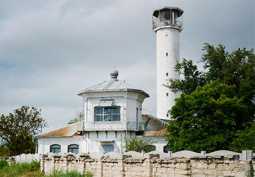
1888. Active; focal plane 37 m (121 ft); white light, 6 s on, 18 s off. 12 m (36 ft) octagonal cylindrical masonry tower with lantern and gallery, rsing from the front of a 1-story masonry keeper's house. Lighthouse painted white. A 2009 photo is at right, Alexandr Deev has a closeup from the rear of the lighthouse, Aleksandr Potapov has a photo, Confluence.org has a photo (second photo on the page), and Bing has a satellite view of the station. War damage at the lighthouse was repaired in 1956, and the station was restored in 1978. Cape Chauda is the eastern extremity of Feodosiya Gulf, a bight on the southeastern coast of Crimea. Located on the point of the cape, about 12 km (7.5 mi) southwest of Cornomorske. Site and tower closed (restricted area) but the lighthouse can be seen from a distance. ARLHS UKR-008; Admiralty N5352; NGA 18404.

Mys Chauda Light, Cornomorske, April 2009
ex-Panoramio Creative Commons photo by mail.cr

Feodosiya City Lighthouses
Feodosiya was founded as a Greek colony in the 6th century BCE. In the late Middle Ages it became a Genoese outpost called Caffa; after being captured by the Ottomans in 1475 it was known as Kefe until Russia conquered the area in 1783. The modern city is a small port and resort area with a population of about 70,000.

Feodosiya Zapadnaya Naberezhnaya (Western Embankment)
Date unknown. Active; focal plane 19 m (62 ft); continuous green light. Approx. 18 m (59 ft) tapered square skeletal tower carrying a lantern structure. No photo available but Google has a satellite view. This is probably a leading light for the harbor entrance. Located on the Feodosiya waterfront at the southwest corner of the harbor. Site status unknown. Admiralty N5342.2.
Feodosiya Range Front (2?)
Date unknown (station established 1895). Active; focal plane 15 m (49 ft); continuous red light. 17 m (56 ft) post mounted on the roof of a 3-story tower attached to a 2-story building. Building painted white. The building appears to be an abandoned harbor control tower, but a tall mast carries signal lights. A photo is available, Alexey Konishchev has a very distant street view and Bing has a satellite view. This is an approach range for Feodosiya. Huelse has a historic postcard view of the original lighthouse, a tourelle of French design. This lighthouse stood until the 1970s. Located at the (north) end of the main breakwater of Feodosiya. Site status unknown. Admiralty N5342.
* Feodosiya Range Rear (2?)
Date unknown (station established 1895). Active; focal plane 92 m (302 ft); continuous red light. 6 m (20 ft) round cylindrical metal tower painted white. A 2015 photo is available, Aleks Kuledin has a street view, and Google has a satellite view. Located on a steep ridge above the city. Site open, tower closed. Admiralty N5342.1.
* Il'inskiy (Mys Il'inskiy, Mys Il'in, Alekseevskiy) (3)
1953 (station established 1899). Active; focal plane 66 m (217 ft); white light, 3 s on, 3 s off, 3 s on, 6 s off. 15 m (49 ft) round robust brick tower with lantern and gallery, painted white. Maksim Zhubr has the closeup photo at right, Andrey Ivanov has a 2017 photo, Lightphotos.net has a photo, and Google has a street view and a satellite view. The original lighthouse, a wood tower, was funded by a noblewoman in thanks to the town of Feodosiya, where her son recuperated from an illness. A more substantial tower was built in 1912. In World War II German troops installed artillery at the lighthouse, which was then largely destroyed by Soviet naval shelling. This is the landfall light for Feodosiya, located on Mys Il'inskiy about 4 km (2.5 mi) southeast of the city. Site open, tower closed. ARLHS UKR-010; Admiralty N5340; NGA 18384.

Mys Il'in Light, Feodosiya, July 2008
Google Maps photo by Maksim Zhubr
Mys Kiik-Atlama
Date unknown. Active; focal plane 160 m (525 ft); red flash every 5 s. 6 m (20 ft) round cylindrical concrete tower, painted with red and white horizontal bands. A 2018 closeup photo is available and Google has a satellite view. Located atop a very prominent cape at Ordzonikidze, about 8 km (5 mi) south of Mys Il'inskiy. Site open, tower closed. ARLHS UKR-140; Admiralty N5341; NGA 18380.

Sudak City Lighthouses
* Meganom (Meganomskiy, Mys Meganom)
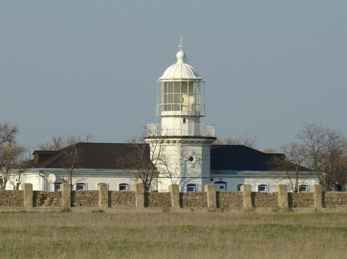
1895. Active; focal plane 99 m (325 ft); three white flashes every 15 s. 12.5 m (41 ft) octagonal masonry tower with lantern and gallery, painted white. A photo is at right, Pavel Zubko has a 2021 photo, Lightphotos.net has Nikita Komarov's photo, Wikimedia has another photo, Dmitry Strelchenko has a street view, and Google has an indistinct satellite view of the station. The lighthouse was damaged during World War II and repaired after the war. Cape Meganom is a very prominent cape on the southeast coast of Crimea; it is well known as the site of an astronomical observatory and important archaeological sites. Located about 10 km (6 mi) southeast of Sudak. Site open, tower closed. ARLHS UKR-014; Admiralty N5330; NGA 18368.
Sudakskiy
Date unknown. Active; focal plane 23 m (75 ft); red light, 1.5 s on, 3.5 s off. Approx. 15 m (49 ft) square cylindrical skeletal tower, painted red. The tower carries a large slatted daymark painted white with a black vertical stripe. Google has a street view from the beach and the light is centered in a Bing satellite view. Located near the ferris wheel in Sudak, a very popular beach resort. Site open, tower closed. Admiralty N5329; NGA 18364.

Alushta Region Lighthouse
* Rybacy (Rybachiy)
1968. Active; focal plane 130 m (427 ft); one long (1.5 s ) white flash every 7.5 s. 21 m (69 ft) round masonry tower mounted on a round masonry base. The lantern has been replaced by several communications towers. Tower painted white with one red horizontal band; the base is unpainted. The Derzhhidrohrafiyu has a good photo (also seen at the top of this page), ARLHS has a photo, Dmitry Sheika has a street view, and Google has a satellite view. The lighthouse was refurbished in 1985. Located on a steep bluff about 2.5 km (1.5 mi) southwest of Rybacy. Site open, tower closed. ARLHS UKR-027; Admiralty N5328; NGA 18360.
Meganom Light
Meganom Light, Sudak, June 2010
Wikimedia Creative Commons photo by Q-lieb-in

Yalta City
Lighthouses
Artek
1977. Reactivated (inactive 1994-2006); focal plane 125 m (410 ft); three white flashes every 7.5 s. 12 m (39 ft) skeletal mast atop a round tower, painted with red and white horizontal bands. The Derzhhidrohrafiyu has a photo and Google has a satellite view. Founded in 1925, Artek became the largest youth camp in the Soviet Union; it was redeveloped by Ukraine as a summer camp for disadvantaged, handicapped, or gifted children. Its current status is unknown. The light was restored and reactivated in 2006. Located on the heights above the camp's 7000-seat sports stadium, about 25 km (15 mi) northeast of Yalta. Site status unknown. Admiralty N5323; NGA 18350.
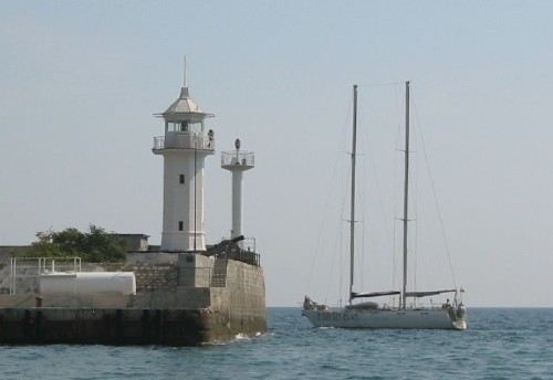
* Yalta Breakwater (Yaltinskiy) (2)
1957 (station established 1891). Probably inactive. 12 m (39 ft) octagonal cylindrical stone tower with lantern and gallery, painted white. The light (focal plane 15 m (49 ft); red light, 3 s on, 4.5 s off) is probably shown from the nearby 9 m (30 ft) post. A 1-story masonry keeper's house is set into the pierhead. Vyacheslav Argenberg's photo is at right, Wikimedia has a photo by Andrew Butko, Trabas has a photo, Aleksey Boldyrev has a distant street view, and Google has a satellite view. Huelse has a postcard view of the earlier lighthouse, a cast iron tourelle of typical French design. It actually survived World War II but in increasingly dilapidated condition. This is one of the best-known lighthouses of Crimea. Located at the end of the Yalta breakwater, which extends southwestward parallel to the shoreline. Site open, tower closed; the lighthouse can also be seen easily from anywhere on the waterfront. ARLHS UKR-034; Admiralty N5320; NGA 18344.
* Ay-Todorskiy (Mys Aytodor, Ajtodor, Ai-Todor) (3)
1944 (station established 1835). Active; focal plane 87 m (285 ft); two green flashes every 6 s. 9 m (30 ft) octagonal tower with lantern and gallery, painted white. The Derzhhidrohrafiyu has a photo, Sergey Baroda has a closeup photo, Huelse has a historic postcard view, and Google has a satellite view. The Russian article says the lighthouse is built on or near the foundation of a Roman signal tower. The present lighthouse is a copy of the 1876 lighthouse, which was destroyed in World War II. This was one of several light stations occupied by Russian Navy personnel during Ukraine's administration of Crimea. The precipitous cliffs of Cape Aytodor are a spectacular sight. Located on the cape about 6 km (4.5 mi) south of Yalta. Site normally open in the past; tower closed. ARLHS UKR-001; Admiralty N5316; NGA 18340.
Yalta Light
Yalta Breakwater Light, Yalta, September 2005
Flickr Creative Commons photo copyright Vyacheslav Argenberg

Information available on lost lighthouses:

Notable faux lighthouses:

Adjoining pages: North: Ukraine: Sea of Azov | East: Russia: Eastern Black Sea and Sea of Azov | West: Sevastopol'

Return to the Lighthouse Directory index | Ratings key

Posted February 19, 2007. Checked and revised August 18, 2021. Lighthouses: 31. Site copyright 2021 Russ Rowlett and the University of North Carolina at Chapel Hill.