Lighthouses of the Republic of Cyprus

Cyprus, the third largest island of the Mediterranean Sea, is located south of Turkey. The island was conquered by the Ottoman (Turkish) Empire in 1571 and remained under Ottoman rule for three centuries. Cyprus came under British rule in 1878 following the Russo-Turkish War. After 82 years of British rule the island became the Republic of Cyprus (Κυπριακή Δημοκρατία, Kypriakí Dimokratía, in Greek) in 1960 under a constitution drafted in an effort to balance the interests of Greek and Turkish Cypriots. Britain retained sovereignty over two large military bases, Akrotíri and Dhekelia, on the south coast. Unfortunately the political compromise dissolved into violence in 1974. Turkish troops intervened and occupied the northern third of Cyprus, establishing the Turkish Republic of Northern Cyprus. United Nations troops administer the Buffer Zone, commonly called the Green Line, a narrow zone separating the Greek and Turkish sections of the island. The Turkish Republic is not recognized diplomatically by any country except Turkey.

Lighthouses in the (Greek) Republic of Cyprus are maintained by the Cyprus Ports Authority. The Greek word for a lighthouse, pháros or fáros (φάρος), is the root for the words in many Western European languages. In Greek nisis is an island, akra is a cape or headland, and kolpós is a bay or gulf. In Cyprus the word kávo (κάβο) is also used for a cape.

ARLHS numbers are from the ARLHS World List of Lights. Admiralty numbers are from volume N of the Admiralty List of Lights & Fog Signals. U.S. NGA List numbers are from Publication 113.

General Sources
Online List of Lights - Cyprus
Photos by various photographers posted by Alexander Trabas. Many of the Cyprus photos are by Capt. Peter Mosselberger ("Capt. Peter"). This page includes lights of both Greek and Turkish republics.
Lighthouses in Cyprus
Photos by various photographers available from Wikimedia.
World of Lighthouses - Cyprus
Photos by various photographers available from Lightphotos.net.
Weitere Europäische Leuchttürme auf historischen Postkarten
Historic postcard views posted by Klaus Huelse.
GPSNauticalCharts
Navigation chart for Cyprus.
Navionics Charts
Navigation chart for Cyprus.


Kávo Nkréko (Cape Greco) Light, Ayia Napa, September 2022
Google Maps photo by Ivan Hollander

Lighthouses
Kávo Nkréko (Cape Greco)
1892. Active; focal plane 16 m (52 ft); one long (1.5 s) white flash every 15 s. 15 m (49 ft) round masonry tower with lantern and gallery. Entire lighthouse painted white. Ivan Hollander's 2022 photo is at the top of this page, Trabas has a photo, a 2017 photo is available, Valery Bespalko has a good photo, Wikimedia has Maxim Ulitin's 2012 photo, Peter Löfqvist has a view from the sea, and Google has a satellite view. Cape Greco, the southeastern tip of Cyprus, is at the end of a long, slender peninsula. Located about 8 km (5 mi) southeast of Ayia Napa. Site and tower closed; all views are from the sea. . ARLHS CYP-003; Admiralty N5888; NGA 20940.
* [Dhekelia Beacon]
Date unknown. Inactive daybeacon. Approx. 12 m (39 ft) round conical tower painted with black and white horizontal bands. Pavel Morozov has a street view and Google has a satellite view. Located on the beach in the British Sovereign Base Area of Dhekelia. Site open, tower closed.
* Kávo Kíti (Cape Kiti, Lárnaka, Pervolia) (2)
Date unknown (station established by the Ottoman government in 1864). Active; focal plane 20 m (66 ft); three white flashes every 15 s. 8 m (26 ft) octagonal stone tower with lantern and gallery, attached to one corner of a 1-story masonry keeper's house. The tower is unpainted; lantern painted white. A 2023 photo by Zdravko Stefanov is at right, Trabas has Andreas Köhler's photo, Maik Schneider has a 2015 photo, Marcel Berendsen has another closeup, Tryfon Kais has a 2023 photo, Michal Štourač has a 2017 street view, and a Google has a satellite view. The lighthouse was under renovation in 2005. The original light was shown on a mast atop a white house, and that light was still listed in 1909. Located on a promontory at Kiti, about 12 km (7.5 mi) south of Lárnaka in the village of Pervólia. Site open, tower closed. ARLHS CYP-004; Admiralty N5882; NGA 20904.
* Lemesós (Limassol) New Marina Southeast Breakwater
2013. Active; focal plane about 8 m (26 ft); flash every 15 s, white or green depending on direction. Approx. 6 m (20 ft) round cylindrical tower with lantern and gallery. The tower is white, lantern green. Trabas has Capt. Peter's photo, Vadim Mirushchenko has a photo, and Google has a satellite view. Located at the end of the main breakwater of the New Marina at Lemesós (Limassol). Site open, tower closed. Admiralty N5879.1.
* Lemesós (Limassol) Range Rear (2)
2014. Active; focal plane 12 m (39 ft); green light occulting once every 5 s. Approx. 10 m (33 ft) square skeletal tower carrying a diamond-shaped slatted daymark; daymark painted orange. Trabas has Capt. Peter's photo and Google has an indistinct satellite view. This tower replaced a tower listed with a focal plane of 12 m (39 ft). The front light is on a similar but much shorter tower. Located in a wetlands area southwest of the commercial harbor of Lemesós. Site open, tower closed. Admiralty N5878.1; NGA 20896.

Kávo Kíti Light, Pervólia, February 2023
Google Maps photo by Zdravko Stefanov
Kávo Gáta (Cape Gata, Akrotíri) (1)
1864 (Ottoman). Inactive. 8 m (26 ft) octagonal cylindrical masonry tower with lantern and gallery, attached to a 1-story masonry keeper's house. The lighthouse was originally painted white. Endangered by lack of maintenance. A photo and a second photo on Mapio.net show the lighthouse in very poor condition, but the second photo shows solar panels for the light. Dennis Thompson also has a photo, and Joni McFarland-Johnston has a distant view from the sea. Google's satellite view shows the active light (focal plane 58 m (190 ft); white flash every 5 s) on the southeast side of the historic lighthouse. We need more information on the status of this historic lighthouse. The lighthouse stands on the southernmost tip of Cyprus within the British Sovereign Base Area of Akrotíri. Located on the point of the cape, about 8 km (5 mi) southeast of Akrotíri and 20 km (13 mi) south of the city of Lemesós (Limassol). Site and tower closed. ARLHS CYP-002. Active light: Admiralty N5876; NGA 20856.
* Páfos (Paphos)
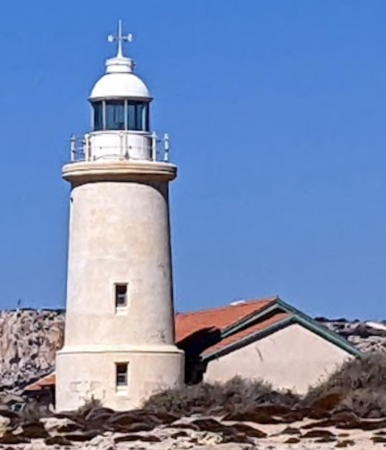
1888. Active; focal plane 36 m (118 ft); one long (1.5 s) white flash every 15 s. 20 m (66 ft) round stone tower with lantern and gallery. Entire lighthouse painted white. The lighthouse stands next to a second century Roman amphitheater, part of which is seen a 2004 photo. A 2022 photo by Stefan Obcas is at right, Dave Gunn has a photo, Jean-Philippe Hebrard has a 2016 photo, Michał Skarbiński has a 2021 photo, Trabas has a photo by Rainer Arndt, Marko Forsten has a photo, Huelse has a historic postcard view, Anton Gladikov has a street view, and Google has a satellite view. This handsome British Imperial tower is the best known and most visited lighthouse of Cyprus. Páfos is at the southwestern corner of the island, where the lighthouse served as the landfall light for ships arriving from Britain. Located on a promontory projecting into the Mediterranean at Paphos. Site open, tower closed. . ARLHS CYP-005; Admiralty N5908; NGA 20836.
Kávo Akáma (Cape Akamas)
1989. Active; focal plane 211 m (692 ft); two white flashes every 15 s. 4.5 m (15 ft) light mounted at one corner of a 1-story stone building (a former British Army observation post). Lightphotos.net has a closeup photo, Xenis Xenakis has a 2021 photo, ARLHS has a photo, qsl.net has a portfolio of photos by amateur radio operator 5B8AP, Markos Kyriacou has a more distant view, Daniel Scotcher has a drone view, and Google has a satellite view. Located atop the bluff at the westernmost tip of Cyprus, about 80 km (50 mi) north northwest of Paphos. Accessible by a long hike or a rough ride by 4x4 vehicle. Site open, building closed. Site manager: Akamas Peninsula National Park. ARLHS CYP-001; Admiralty N5907.6; NGA 20986.

Páfos Light, Páfos, August 2022
Google Maps photo by Stefan Obcas

Information available on lost lighthouses:

Notable faux lighthouses:

Adjoining page: North: Northern Cyprus

Return to the Lighthouse Directory index | Ratings key

Posted May 14, 2007. Checked and revised May 21, 2024. Lighthouses: 7. Site copyright 2024 Russ Rowlett and the University of North Carolina at Chapel Hill.