Lighthouses of Northern Cyprus

Cyprus, the third largest island of the Mediterranean Sea, is located south of Turkey. The island was conquered by the Ottoman (Turkish) Empire in 1571 and remained under Ottoman rule for three centuries. Cyprus came under British rule in 1878 following the Russo-Turkish War. After 82 years of British rule the island became an independent republic in 1960 under a constitution carefully drafted in an effort to balance the interests of Greek and Turkish Cypriots. Britain retained sovereignty over two large military bases, Akrotíri and Dhekelia, on the south coast. Unfortunately the political compromise dissolved into violence in 1974. Turkish troops intervened and occupied the northern third of Cyprus, establishing the Turkish Republic of Northern Cyprus (Kuzey Kıbrıs Türk Cumhuriyeti in Turkish). United Nations troops administer the Buffer Zone, commonly called the Green Line, a narrow zone separating the Greek and Turkish sections of the island. The Turkish Republic is not recognized diplomatically by any country except Turkey.

Since the 1920s the Turkish language has been written in a Latin script; a distinctive feature of the alphabet is that the dotted (İ and i) and dotless (I and ı) forms of the letter I are different letters. The Turkish phrase for a lighthouse is fener (plural fenerler) or deniz feneri ("sea lantern"). Ada or adası is an island, yarımada is a peninsula, kaya is a rock or reef, burnu is a cape, burun ("nose") is a headland, körfez is a gulf, koy is a bay or inlet, boğaz is a strait, nehir is a river, and liman is a harbor.

Lighthouses in the Turkish Republic of Northern Cyprus are maintained by the Turkish Cyprus Coastal Safety and Salvage Directorate.

ARLHS numbers are from the ARLHS World List of Lights. KTGK numbers are from the list provided by the coastal safely directorate. Admiralty numbers are from volume N of the Admiralty List of Lights & Fog Signals. U.S. NGA List numbers are from Publication 113.

General Sources
Online List of Lights - Cyprus
Photos by various photographers posted by Alexander Trabas. This page includes lights of both Greek and Turkish republics. Most of the photos for Northern Cyprus are by Rainer Arndt.
World of Lighthouses - Northern Cyprus
Photos by various photographers available from Lightphotos.net.
Europäische Leuchttürme auf historischen Postkarten
Historic postcard views posted by Klaus Huelse.
Northern Cyprus Light List
Salvaged from the Internet, this is an official but undated list of lights.
GPSNauticalCharts
Navigation chart information for Cyprus.
Navionics Charts
Navigation chart for Cyprus.


Canbulat Light, Mağusa (Famagusta), February 2022
Twitter (X.com) photo by UN Development Programme Cyprus
Northwest Coast Lighthouses
* Denizli (Xeros) Pier
Date unknown. Inactive. 7 m (23 ft) square skeletal tower mounted on the roof of a waterfront building. Trabas has Arndt's photo, Eberhard Spittler has a photo, and Google has a satellite view. The seafront is dilapidated and the pier is collapsing and useless. Although the light still appears on international lists it is not on the official Northern Cyprus list. Located on the waterfront of Denizli (historically known as Xeros), a village in northwestern Cyprus, not far from the western end of the Green Line. Site open, tower closed. Admiralty N5906; NGA 20980.
Koruçam Burnu (Kormacit, Cape Kormakiti, Cape Komakitis, Cape Koruçam) (2)
1991 (station established 1940s). Active; focal plane 30 m (98 ft); two white flashes every 20 s. 20 m (66 ft) square pyramidal steel skeletal tower, painted white. Evgeny Gavrilyuk has a 2018 photo, a 2010 photo is available, Erol Savaş has a 2015 street view, and Google has a satellite view. Cape Koruçam is a sharp promontory on the northwest coast of Cyprus. Located on the point of the cape, about 25 km (15 mi) west of Lapta (Lapithos). Accessible by 4WD vehicles. Site open, tower closed. ARLHS CYP-007; KTGK 33250; Admiralty N5904; NGA 20976.

Girne Lighthouses
Girne (Kyrenia) is the principal port on the north coast of Cyprus; ferries arrive here from Alanya and Mersin on the south coast of Turkey. An important port and fortified town since at least the 12th century BCE, Kyrenia has been governed by Greeks, Romans, the Byzantine Empire, Frankish crusaders, and Venetians before being captured by the Ottoman (Turkish) Empire in 1571.

* Girne (Kyrenia) West Mole (1)
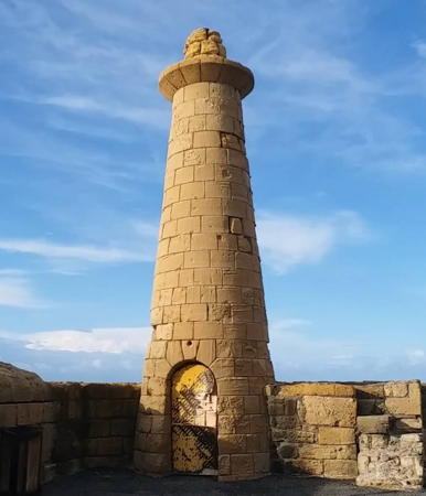
1907. Inactive since 1963. 7 m (23 ft) round strongly conical stone tower. The tower is unpainted. Bilal Canatar's 2024 photo is at right, Craig Wiggins has a photo, a closeup photo is available, Wikimedia has a 2014 photo, Huelse has a historic postcard view, Stephan Christoph has a street view, and Google has a distant satellite view. The old harbor of Kyrenia, used now as a yacht and small boat marina, has been extended by constructing a long breakwater attached to the west mole. Located at the end of the old west mole, now an elbow of the extended mole. Site open, tower closed.
* #Girne (Kyrenia) West Mole (3?)
Early 2010s. Replaced. This was an 8 m (26 ft) round barbell-shaped white tower. Sam Garton has a 2016 street view. Apparently it served only a short time. The current light is on post (focal plane 10 m (33 ft); green flash every 5 s); Trabas has Arndt's photo, a 2022 street view is available, and Bing has a satellite view. The 1963 light was a rusty square skeletal tower seen in Lisa Solonynko's 2010 photo and a Lightphotos.net 2011 photo. Located at the end of the extended breakwater of the yacht and small boat marina. Accessible by walking the pier. Site open, tower closed. KTGK 33230; Admiralty N5902; NGA 20972.

1907 West Mole Light, Girne (Kyrenia), May 2024
Google Maps photo by Bilal Canatar
* Girne (Kyrenia) (1)
1886. Inactive. 24 m (79 ft) round stone tower mounted atop the northwest bastion of the Kyrenia fortress. The Jenkins 1904 light list describes the light as "shone from a mast over a small white hut" atop the tower. Dmytro Latanskyi has a photo of the tower, Amanda Slater has a good photo, Mehmet Aktekin has a street view and Google has a satellite view. Located on the Kyrenia waterfront. Site and tower open.
* Girne Ana (Kyrenia Main)
1994. Active; focal plane 19 m (58 ft); three white flashes every 20 s. 7 m (23 ft) square cylindrical skeletal tower with gallery, mounted atop a multistory building. Skeletal tower colored with red and white horizontal bands. Google's satellite view of the building does not reveal the tower. This light guides vessels into the ferry and commercial harbor, which is a short distance east of the old harbor. Located on a building facing the ferry harbor. Site open, tower closed. KTGK 33226; Admiralty N5901.6; NGA 20971.
Girne (Kyrenia) North Breakwater (2)
Date unknown. Active; focal plane 12 m (39 ft); green flash every 3 s. 8 m (26 ft) round hourglass-shaped tower, painted white. Trabas has Arndt's closeup photo and Bing has a satellite view. Located at the end of the north breakwater of the ferry harbor. Site status unknown. KTGK 33236; Admiralty N5902.6; NGA 20973.
Girne (Kyrenia) South Breakwater
Date unknown. Active; focal plane 12 m (39 ft); red flash every 3 s. 8 m (26 ft) round concrete tower with gallery, painted white. Trabas has Arndt's closeup photo, Mehmet Koray Kose has a 2022 view from the sea, Huseyin Karslı also has a view from the sea, and Bing has a satellite view. Located at the end of the south (really east) breakwater of the ferry harbor. Site status unknown. KTGK 33234; Admiralty N5902.4; NGA 20973.5.

Northeast Coast Lighthouses
* Alıcı Burnu (Yeni Erenköy) (2)
Date unknown. Active; focal plane 22 m (72 ft); two white flashes every 15 s. 6 m (20 ft) round cylindrical white concrete tower. Trabas has Arndt's closeup photo, another photo is available, and Google has a satellite view. NGA lists a 3 m (10 ft) tower. Located on a steep headland of the northeast peninsula near Yeni Erenköy. Site open, tower closed. KTGK 33220; Admiralty N5901; NGA 20970.
Zafer Burnu (Cape Andreas, Klidhes Islands) (2)
1991 (station established 1913). Active; focal plane 20 m (66 ft); four white flashes every 20 s. 10 m (33 ft) round hourglass-shaped steel tower, painted white. Trabas has a photo by Capt. Peter Mosselberger and Google has an aerial photo and a satellite view. This lighthouse is similar to many lights installed in Turkey around the same time. Zafer Burnu (Cape Andreas) is the tip of a long, sharp-pointed peninsula that projects from the northeast corner of Cyprus. The lighthouse is located on a small island off the end of the peninsula, one of several representing summits of an underwater ridge. Accessible only by boat. Site status unknown. ARLHS CYP-010; KTGK 33210; Admiralty N5900; NGA 20968.
Elea (Zeytinlik Burnu, Cape Elea) (2?)
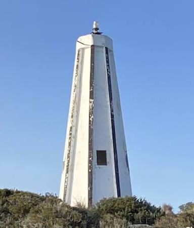
Date unknown. Active; focal plane 31 m (102 ft); white flash every 10 s. 11 m (36 ft) octagonal pyramidal concrete tower with ribs at each edge. Lighthouse painted white; the ribs are painted black, so at a distance the lighthouse appears white with narrow black vertical stripes. There is an enclosure in the base of the tower but access to the light is by an external ladder. Chris and Angela Pye have the 2008 photo seen at right and Bing has a satellite view. Located in Çayırova on a promontory on the south side of the Zafer Burnu (Cape Andreas) peninsula. Site status unknown. ARLHS CYP-006; KTGK 33110; Admiralty N5898; NGA 20965.

Zeytinlik Burnu (Cape Elea) Light, Çayırova, April 2008
Flickr Creative Commons photo by Chris and Angela Pye
* Karakol (Famagusta Northwest) (2)
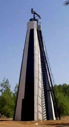
Date unknown (station established 1906). Active; focal plane 18 m (59 ft); flash every 7 s, white or red depending on direction. 11 m (36 ft) square pyramidal concrete tower, painted with black and white vertical stripes. A photo is at right and Google has a satellite view. This lighthouse guides vessels approaching the harbor of Mağusa (Famagusta). Located on the northwest side of the city in an area that appears to be occupied by government buildings. Site open, tower closed. ARLHS CYP-008; KTGK 33140; Admiralty N5893; NGA 20948.
[Famagusta (Gazimağusa) Outer Breakwater]
Date unknown. Active; focal plane 10 m (33 ft); five red flashes every 5 s. 6 m (20 ft) square white skeletal tower on a round conctete base. Trabas has Arndt's photo and Google has a satellite view. There is an identical light on the inner breakwater. Located on the main breakwater of the harbor. This is not a walkable pier. Site and tower closed. KTGK 33150; Admiralty N5894; NGA 20952.
* Canbulat (Mağusa, Gazimağusa, Famagusta Southeast Bastion) (3?)
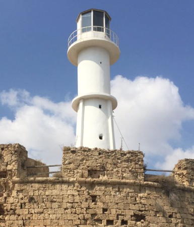
1972 (station established 1888). Active; focal plane 23 m (75 ft); two white flashes every 15 s. 11 m (36 ft) 2-stage round cylindrical tower with lantern and double gallery; the lower stage is stone and the upper stage is metal. It seems likely that the lower stage is the original 1906 lighthouse. Entire lighthouse painted white. A 2022 photo is at the top of this page, Trabas has Arndt's closeup photo, Wikimedia has a 2014 photo, Wayne Hopkins has a 2011 photo, Alexandr Zheleznyak has a photo, the Canbulat Museum has a 2017 photo, Dalga Tatar has a street view atop the fortress, and Google has a satellite view. During medieval times the city was one of the richest in the Middle East. Venice, which controlled the city from 1489 to 1571, fortified it with high stone walls. The lighthouse is built on the walled city's southeast bastion (the Djamboulat Bastion), adjacent to the base of the harbor. The first light was on a mast; it was replaced by a stone tower in 1906. Site open, tower closed. ARLHS CYP-009; KTGK 33130; Admiralty N5892; NGA 20944.

Information available on lost lighthouses:

Notable faux lighthouses:


Karakol Light, Mağusa
Coastal Safety Directorate photo

Adjoining pages: North: Southern Turkey | South: Republic of Cyprus

Return to the Lighthouse Directory index | Ratings key

Posted May 14, 2007. Checked and revised May 21, 2024. Lighthouses: 13. Site copyright 2024 Russ Rowlett and the University of North Carolina at Chapel Hill.