Lighthouses of Germany: Cuxhaven and Stade

The Federal Republic of Germany (Bundesrepublik Deutschland in German) occupies a central location in northern Europe with two coastlines, one facing northwest on the North Sea and the other facing northeast on the Baltic Sea. The country's history is long and complex. The large number of historically independent German regions came together in 1871 to form the German Empire. The Empire became a republic after World War I (1914-18). After World War II (1939-45) Germany was divided into two countries, the German Federal Republic in the west, usually called West Germany, and the Communist-led German Democratic Republic in the east, usually called East Germany. After the Communist government collapsed the Federal Republic reunified the nation in October 1990.

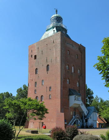
The Federal Republic is a federation of sixteen states (Länder) and the states are divided into districts (Kreise). This page describes lighthouses of the Elbmündung (the approach to the River Elbe) and the south side of the lower Elbe in the Cuxhaven and Stade Districts of the state of Lower Saxony (Niedersachsen). Also included is the historic Elbmündung lighthouse of Neuwerk, shown at right; it is under the juristiction of the city-state of Hamburg. Lighthouses on the north side of the lower Elbe are described on the North Frisia page and those higher on the Elbe are described on the Hamburg Area page.

Interest in lighthouses is strong in Germany and most of the towers are in good condition. A federal law provides blanket protection to historic lighthouses. There is concern, however, that many of the lights may be deactivated in the coming years as navigators depend less and less on them.

In German a lighthouse is a Leuchtturm ("light tower"), plural Leuchttürme. The front light of a range is the Unterfeuer and the rear light is the Oberfeuer. There are many modern range lighthouses and most of these towers are crowned by a topmark: a large, distinctive structure that serves to mark the range clearly in the daytime. Some topmarks are conical, others are funnel-shaped, and some consist of one or more gallery-like rings around the tower.

In German Insel is an island, Riff is a reef, Kap is a cape, Bucht is a bay, Fluss is a river, Mündung is a river mouth or estuary, and Hafen is a harbor. The word Straße ("street") is also used for a waterway or strait.

Lighthouses in Germany are operated by the regional harbor authority, called the WSA (Wasserstraßen- und Schiffahrtsamt). All the lights on this page are maintained by WSA Elbe-Nordsee. The WSA's are linked to and regulated by a federal agency, the Wasserstraßen- und Schifffahrtsverwaltung des Bundes (WSV).

ARLHS numbers are from the ARLHS World List of Lights. DE numbers are the German light list (Leuchtfeuerverzeichnis) numbers as noted on Erich Hartmann's website. Admiralty numbers are from volume B of the Admiralty List of Lights & Fog Signals. U.S. NGA List numbers are from NGA Publication 114.


Neuwerk Light, Neuwerk, June 2018
Wikimedia Creative Commons photo by Jörg Braukmann

General Sources
Leuchttürme und Leuchtfeuer an der Nordsee
Photos and information posted by Erich Hartmann, a contributor to the Online List of Lights.
Online List of Lights - Germany North Sea
Photos by various photographers posted by Alexander Trabas. Some of the Elbe photos are by Hartmann, Rainer Arndt, or Capt. Peter Mosselberger ("Capt. Peter").
Leuchtturm-Atlas
A large site with excellent photos and information on nearly all German lighthouses, maintained by Frank and Birgit Toussaint.
Leuchttürme.net - Deutschland
Outstanding photos by Malte Werning.
Lighthouses in Germany
Photos available from Wikimedia.
Germany Lighthouses
Aerial photos posted by Marinas.com.
Leuchtturmseiten von Anke und Jens - Germany
This site has photos and information on many of the lights.
Deutsche Leuchttürme und Seezeichen
Photos posted by Klause Huelse. Huelse also has a large collection of historic postcard views.
Schifffahrtszeichen
Lighthouse information from WSA Elbe-Nordsee.
Interessengemeinschaft Seezeichen e.V.
Germany's national lighthouse preservation organization.
GPSNavigationCharts
Navigation chart information for the Elbe.
Navionics Charts
Navigation chart for the Elbe.
 
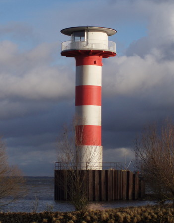
Mielstack Unterfeuer
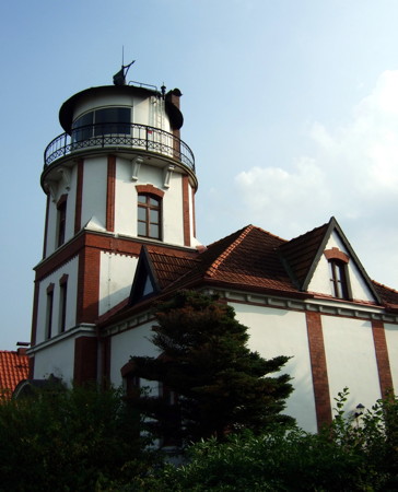
1907 Mielstack Unterfeuer, Lühe, August 2011
Flickr Creative Commons photo by Margret Pirzer

Elbmündung Offshore (Neuwerk Area) Lighthouses

These lights guide vessels through the shallows of the North Sea to the mouth of the Elbe River. Neuwerk is an island in the North Sea about 13 km (8 mi) north northwest of the entrance to the river. In 1969 the city-state of Hamburg surrendered to the state of Niedersachsen its historic harbour rights in Cuxhaven in return for jurisdiction over the island of Neuwerk and its smaller neighbors Scharhörn and Nigehörn.

Großer Vogelsand
1975. Light inactive since 1999; fog horn inactive since 2004. The tower was formerly floodlit at night. Originally this was a 39 m (128 ft) round cylindrical concrete tower with a large, 3-story lantern and keeper's quarters structure, topped by a helipad. Lighthouse painted with red and white horizontal bands. Werning's page has a good photo and Leuchtturm-Atlas also has a good photo. This large modern lighthouse cost 15 million marks, making it the most expensive lighthouse ever built in Germany. It replaced the Elbe 2 lightship in warning ships away from the extensive shallows on the north side of the Elbe entrance. After deactivation the lighthouse was leased with the intention of making it available for overnight accommodations and conferences. These plans collapsed due to the very high costs estimated for renovation. In December 2008 the upper section of the lighthouse was removed and barged to Bremerhaven to be scrapped. Instead, it was purchased by a Bremerhaven hostel (see the Bremerhaven page). The rest of the lighthouse is still standing; Hartmann has a photo and Google has a satellite view. It has no light but carries radar reflectors. Located about 9 km (5.5 mi) north of Neuwerk and 20 km (13 mi) northwest of Cuxhaven. ARLHS FED-007; ex-Admiralty B1340.
**** Neuwerk
1814. Active; focal plane 38 m (125 ft); three long (2 s) flashes every 20 s, white, red, or green depending on direction. 39 m (128 ft) square masonry tower with lantern centered on a square pyramidal roof. Jörg Braukmann's photo is at the top of this page, Werning has a good page for the lighthouse, Trabas has a closeup photo, Mortimer Griepentrog has a street view, and Google has a satellite view. Built by Hamburg around 1300-1310 as a fortified watchtower, the lighthouse is the oldest building on the German coast. It served mariners for 500 years as a daybeacon before being converted to a lighthouse by addition of a large lantern on the roof. It is now a national historic site with apartments in the tower available for overnight rental. In 2013 WSA Cuxhaven announced it would deactivate the light at the end of the year, since it is no longer needed for navigation. In response WSA Hamburg agreed to take over the station and continue to operate the light, given its historical significance. Both of these WSA's have been merged since into WSA Elbe-Nordsee. Located at the southern end of the island. The island is accessible by passenger ferry from Cuxhaven. Operator (light): WSA Elbe-Nordsee; Accommodations manager: Pension Leuchtturm Neuwerk. Site manager: Nationalpark Wattenmeer. . ARLHS FED-165; DE 309200; Admiralty B1344; NGA 10436.
Neuer Leuchtergrund E
2010(?). Active; focal plane 23 m (75 ft); continuous white light. 23 m (75 ft) round cylindrical tower with double gallery. Tower painted with green, white, and buff bands. WSA Elbe-Nordsee posted the closeup photo seen at right, Trabas has Rainer Arndt's photo, and Google has a satellite view. This light and the next one bracket the entrance channel for the Elbe. Located on the south side of the channel. Accessible only by boat. Site open, tower closed. Admiralty B1348.8.
Neuer Leuchtergrund X (?)
2010(?). Inactive since 2023. 23 m (75 ft) round cylindrical tower with double gallery. Tower painted with red, white, and buff bands. Trabas has Rainer Arndt's photo and Google has a satellite view. This light may be removed. Located on the north side of the Elbe entrance channel. Accessible only by boat. Site open, tower closed. Admiralty B1348.9.

Neuer Leuchtergrund Light E, 2010
WSA Elbe-Nordsee photo (no longer online)
Gelbsand Unterfeuer
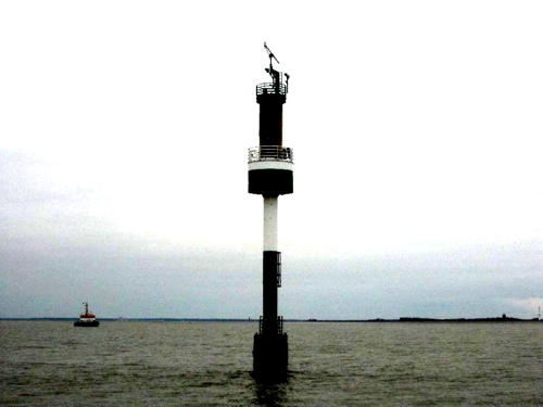
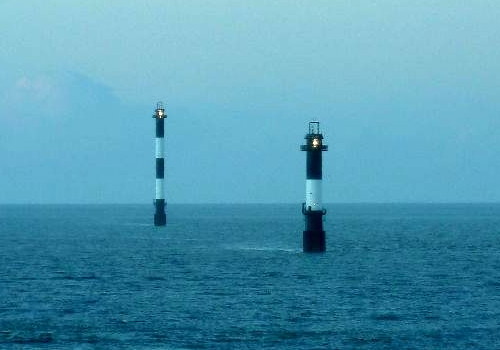
2010. Active; focal plane 25 m (82 ft); white light, 2 s on, 2 s off. 28 m (92 ft) round cylindrical tower with gallery, painted black with one white horizontal band. A photo is at right, Trabas has Helmut Seger's photo and Google has a distant satellite view. These modern light towers were prefabricated at the Voss shipyard in Cuxhaven. This range guides vessels departing the Elbe. Located about 8 km (5 mi) northeast of Neuwerk. Accessible only by boat. Site open, tower closed. DE 309350; Admiralty B1348.49; NGA 10439.
Gelbsand Oberfeuer
2010. Active; focal plane 50 m (164 ft); white light, 2 s on, 2 s off. 53 m (174 ft) round cylindrical tower with gallery, painted with black and white horizontal bands. A photo is at right, Trabas has Arndt's photo and Google has a distant satellite view. Located about 1.1 km (0.7 mi) northwest of the front light. Accessible only by boat. Site open, tower closed. DE 309351; Admiralty B1348.5; NGA 10439.1.
Cuxhaven Northwest V
2015(?). Active; focal plane 23 m (75 ft); continuous white light. 23 m (75 ft) round cylindrical tower with double gallery. Tower painted with red, white, and buff bands. Trabas has Rainer Arndt's photo, Clifford Schäfersküpper has a very distant view, and Google has a distant satellite view. This light and the next one bracket the entrance channel for the Elbe. Located on the north side of the channel. Accessible only by boat. Site open, tower closed. Admiralty B1349.9; NGA 10442.2.
Cuxhaven Northwest G
2015(?). Active; focal plane 23 m (75 ft); continuous white light. 23 m (75 ft) round cylindrical tower with double gallery. Tower painted with green, white, and buff bands. Trabas has Rainer Arndt's photo and Google has a distant satellite view. Located on the south side of the channel. Accessible only by boat. Site open, tower closed. Admiralty B1349.8; NGA 10442.1.
Gelbsand Lights
Gelbsand Oberfeuer (left) and Unterfeuer, Elbmündung, 2010
WSA Elbe-Nordsee photo (no longer online)

Northern Cuxhaven District Lighthouses

The Cuxhaven District also includes the Sandstedt area on the Weser estuary south of Bremerhaven and the municipality of Wurster Nordseeküste on the coast between Cuxhaven and Bremerhaven. Sandstedt lighthouses are listed on the Bremen page and Wurster Nordseeküste lighthouses on the Bremerhaven page.

Cuxhaven Lighthouses
* Duhnen (2)
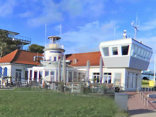
1958 (station established 1898). Officially inactive since 1980 but an unofficial white light is displayed. Approx. 9 m (30 ft) lantern mounted atop a 2-story building. Building and lantern painted white; building has an orange tile roof. A 2018 street view is at right, Werning has a good photo, Huelse has a historic postcard view, and Google has a satellite view. The original lighthouse was a square wood tower. The present building is now a café and bar adjacent to a popular seaside resort. The light tower was renovated in 2019. Located at the west end of the North Sea waterfront of Duhnen, just west of Cuxhaven at the southern entrance to the Elbe estuary. Site open, building open but tower closed. Owner: Nordseebad Cuxhaven-Duhnen. Site manager: Leuchtfeuer Cuxhaven. ARLHS FED-072; ex-Admiralty B1358.
* [Kugelbake]
Late 1940s (station established 1703). Unlit beacon, floodlit at night. 30 m (98 ft) quadrupod wood tower with a vertical slatted daymark, topped by a staff carrying a round daymark simulating a ball. The tower is stained dark brown. Hartmann has a page for the beacon, Wikimedia has a good photo, a fine closeup and a 2021 photo are available, Stefan Eckhardt has a street view, and Google has a satellite view. Since 1703 the Ball Beacon (Kugelbake) has been a traditional landmark and symbol of Cuxhaven. The tower carrying the ball has been rebuilt many times. In 1853 a lighthouse was added, a 7.5 m (25 ft) square skeletal tower with lantern and gallery. This tower was removed when the light was relocated to Duhnen in 1898. In 2001 the WSA removed the historic ball, leading to a great public outcry, and in May 2002 the ball was returned to the City of Cuxhaven for display in a museum setting. Since 1913 a representation of the Kugelbake has appeared on the coat of arms and logo of the city. Located on the point of land at the south side of the entrance to the Elbe, at the northwestern corner of Cuxhaven. Site open, tower closed.

Duhnen Light, Cuxhaven, July 2018
Googel Maps photo by Uwe
**** Lightship Elbe 1 (Bürgermeister O'swald II)
1948 (Jos. L. Meyer, Papenburg). Decommissioned 1988. 49 m (161 ft) steel lightship with light tower and lantern amidships. Hartmann has a page for the lightship, Udo Schweda has a 2021 photo, Erik Kravets has many photos from a visit in July 2016, a good 2008 photo is available, Stefanie Alexejev has a street view, and Google has a satellite view. Launched in 1943, the ship could not be completed and placed into service until after World War II. Stationed off the mouth of Elbe, it was damaged many times by collisions with other vessels, but was always repaired and returned to service. Since its retirement the ship has been moored in Cuxhaven as a museum vessel, tended by volunteer members of the Feuerschiff-Verein Elbe 1. The ship remains in operational condition and has undertaken a number of voyages; Wikimedia has a photo of the ship under way. When in port in Cuxhaven the ship is usually moored at the Havenkaje near Alte Liebe (next entry) during the summer and at the Neuen Fischereihafen during the winter. Site open, vessel open for tours in season; check its web site for current information. Owner/site manager: Feuerschiff Elbe 1 .ARLHS FED-014.
* Cuxhaven ("Alte Liebe")
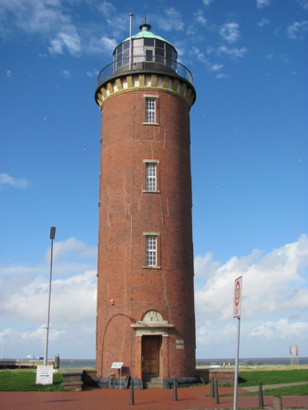
1805. Inactive since 2001; charted as a landmark. 23 m (75 ft) round cylindrical brick tower with lantern and gallery. Tower is unpainted red brick; lantern dome is unpainted green copper. A photo is at right, Markus Bietmann has a 2021 photo, Larry Myhre has a photo, Werning has an excellent page, Wikimedia has a good 2010 photo, Hansjörg Fichtner has a good photo, Huelse has a historic postcard view, and Google has a 2022 street view and a satellite view. A closeup street view shows the entrance to the tower; the Latin inscription above the door reads "As a sign to seafarers, a monument erected by the State of Hamburg in 1803." This historic tower was indeed built by the city of Hamburg; after only a short time in service it was extinguished until the end of the Napoleonic wars in 1814. A second order Fresnel lens was installed in 1892. The physicist Karl-Ferdinand Braun conducted early experiments in radio transmission at the lighthouse in 1899. After almost two centuries of operation the lighthouse (Germany's oldest in service) was deactivated in May 2001 and sold into private ownership. In 2005 the owner, Klaus-Otto Lammert, restored the interior and exterior of the tower. Located on the old waterfront in downtown Cuxhaven. Site open, tower closed. Owner/site manager: private. . ARLHS FED-066; ex-Admiralty B1360; ex-NGA 10456.

Cuxhaven Light (Alte Liebe), September 2011
Wikimedia Creative Commons photo by Dietman007
Steubenhöft (Amerikahafen) (2)
1955 (station established 1913). Active; focal plane 12 m (39 ft); white or green light, depending on direction, occulting once every 4 s. 10 m (33 ft) round cylindrical steel tower with lantern and gallery. Entire lighthouse painted green. Werning has a good page for the lighthouse, Trabas has a closeup photo by Capt. Peter, Sven Dittmann has a photo, and Google has a satellite view. This light was built to guide ships into Amerikahafen, a harbor on the east side of Cuxhaven formerly used by transatlantic liners. The Abschied nach Amerika museum at the base of the pier tells the story of the formr liners and the German emigrants who departed for the New World. Located at the end of a short mole at the east end of the Cuxhaven waterfront. Accessible by walking the pier. Site and tower closed. Operator: WSA Elbe-Nordsee. ARLHS FED-067; DE 309560; Admiralty B1374; NGA 10468.

Altenbruch Area Lighthouses
#Baumrönne Unterfeuer
1971. Inactive since 2010 and demolished in 2011. 25 m (82 ft) round cylindrical concrete tower with lantern and gallery. Lighthouse painted red with a white band on the lower 1/4. The daymark was changed from horizontal black and white bands in early 2008 and several months later a very large triangular daymark was added to the tower. Werning has a fine photo showing the original appearance of the lighthouse. This was the front light of an inbound (eastbound) range; the rear light was on the Altenbruch Oberfeuer. The range was abandoned in 2010 because increasing development of the Cuxhaven waterfront was blocking mariners' view of the light. Bing's satellite view of the location confirms the removal of the lighthouse. Located on the dike at the edge of the Elbe, 2940 m (1.8 mi) northwest of the rear light and about 8 km (5 mi) southeast of Cuxhaven. Site open. ARLHS FED-035; ex-Admiralty B1360.9; ex-NGA 10440.
* Altenbruch (3) Oberfeuer (Neue Schlanke Anna)
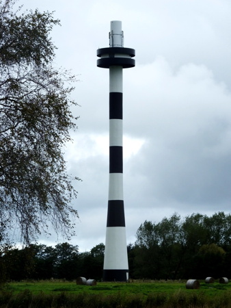
1971. Active; focal plane 51 m (167 ft); white light, 4 s on, 4 s off. 59 m (194 ft) round cylindrical concrete tower with tapered lower portion and double gallery at the 51 m level, painted with black and white horizontal bands. In 2008 the upper portions of the range lighthouses were repainted red and a large triangular daymark was placed on a tall mast next to the tower. By 2015, however, the tower was again painted all black and white. Capt. Peter Mosselberger's photo is at right, Larry Myhre has a 2008 photo showing the red top, Werning has a good page showing the original appearance of the tower, Trabas has a photo by Arndt, and Google has a satellite view. This soaring modern tower, one of Germany's tallest, inherited the traditional nickname Schlanke Anna (Skinny Anna). The original Schlanke Anna, seen in Huelse's postcard view, was demolished in 1976. The tower originally carried a second light, the rear light of the inbound Baumrönne range; that range was discontinued in 2010. Located in a field on the west side of Altenbruch. Site open, tower closed. Operator: WSA Elbe-Nordsee. ARLHS FED-030; DE 309602; Admiralty B1361; NGA 10445.1.

Neue Schlanke Anna, Altenbruch, October 2015
photo copyright Capt. Peter Mosselberger
used by permission
** Altenbruch Unterfeuer (2) (Dicke Berta)
1897 (station established 1871). Inactive since 1983. 13 m (43 ft) round cylindrical steel tower with lantern and gallery. Lighthouse painted white, lantern and gallery black. A photo is at right, Hartmann has a page for the lighthouse, Werning's page has a good photo, Leuchtturm-Atlas has a great closeup photo, Wikimedia has many photos, Silke Selmayr has a 2020 photo, Huelse has a historic postcard view, Christian Icken has a street view, and Google has a 2023 street view and a satellite view. The Altenbruch station has always been crucial for navigators entering the Elbe; from the 16th century sailors steered by the twin towers of the Altenbruch church. Hamburg built a wooden lighthouse on the dike in 1871 and in 1897 replaced it with this tower, which was immediately nicknamed Dicke Berta (Fat Bertha). Huelse also has a postcard view of the 1871 beacon. The lighthouse carried the front light of a range; the rear light was the 34 m (112 ft) cast iron Osterende-Groden Oberfeuer, nicknamed Schlanke Anna (Skinny Anna). Between 1915 and 1918 Dicke Berta was taken down and rebuilt a short distance away because of a change in the range line. The range was replaced in 1968 by the Altenbruch-Wehldorf range, but Dicke Berta remained active until 1983. The lighthouse was then transferred to a preservation society, which has restored the building. The building has since become a popular site for weddings. Located near the Altenbruch harbor. Site open; tower open Saturday and Sunday afternoons Easter weekend through the end of September. Owner: Niedersächsischen Verwaltungsamt-Institut für Denkmalpflege. Site manager: Förderverein Dicke Berta e.V. . ARLHS FED-277.
Altenbruch Unterfeuer (3)
1968 (station established 1871). Active; focal plane 19 m (63 ft); white light 4 s on, 4 s off, synchronized with the rear lights; also red or green lights, 4 s on, 4 s off, are shown for ships to the left or right of the inbound range. 20 m (66 ft) round cylindrical concrete tower with a large lantern and upper and lower galleries. Lghthouse painted with black and white horizontal bands. Hartmann has a page for the range lights, Trabas has Hartmann's closeup photo, Werning has an excellent photo, Mario Weiss has a 2020 photo, and Google has a satellite view. This lighthouse carries the front lights for both the inbound Wehldorf and outbound Altenbruch ranges. Located in the river, 600 m (0.38 mi) northwest of the Wehldorf Unterfeuer. Accessible only by boat. Site and tower closed. Operator: WSA Elbe-Nordsee. ARLHS FED-029; DE 309600; Admiralty B1361.1; NGA 10445.
Dicke Berta
Dicke Berta, Altenbruch, September 2012
Wikimedia Creative Commons photo by Tvabutzku1234
* Wehldorf Oberfeuer
1968. Active; focal plane 31 m (102 ft); white light 4 s on, 4 s off, synchronized with the front light. 29 m (95 ft) round cylindrical concrete tower with double gallery forming a cylindrical topmark. Lighthouse painted with black and white horizontal bands. Trabas has a closeup photo by Ulrich Bode, Mathias Koch has a 2022 photo, Roger Luff has a more distant view, Werning's page has a photo, Marinas.com has aerial photos, and Google has a street view and a satellite view. This is the rear light of an inbound (eastbound) range, one of two guiding ships into the mouth of the Elbe; the front light is carried on the Altenbruch Unterfeuer. Located behind the dike at Altenbruch, about 13 km (8 mi) southeast of Cuxhaven. Site open, tower closed. Operator: WSA Elbe-Nordsee. ARLHS FED-259; DE 309599; Admiralty B1361.2; NGA 10446.

Otterndorf Area Lighthouses
Otterndorf Oberfeuer
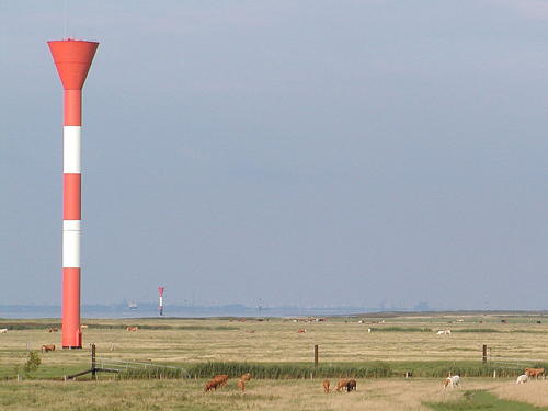
1986. Active; focal plane 52 m (171 ft); white light 2 s on, 2 s off, synchronized with the front light. 52 m (171 ft) round cylindrical tower with a large funnel-shaped topmark, painted with red and white horizontal bands. Trabas has a good photo by Ulrich Bode, Wikimedia has the photo at right also showing the front light in the distance, and Google has a satellite view. Located in a marshy area in front of the dike just east of the Otterndorf harbor entrance. Site and tower closed. Operator: WSA Elbe-Nordsee. ARLHS FED-179; DE 309641; Admiralty B1396.1; NGA 10502.2.
Otterndorf-Belum Unterfeuer
1986. Active; focal plane 23 m (75 ft); white light 2 s on, 2 s off, synchronized with the rear lights. 25 m (82 ft) round cylindrical tower with a large funnel-shaped topmark, painted with red and white horizontal bands. Trabas has a closeup photo by Capt. Peter and Google has a satellite view. This tower carries the front lights for both the inbound Belum and outbound Otterndorf ranges. Located just offshore in the Elbe, 1340 m (0.8 mi) west of the Belum Oberfeuer and 2660 m (1.65 mi) east of the Otterndorf Oberfeuer. Site and tower closed. Operator: WSA Elbe-Nordsee. ARLHS FED-036; DE 309640; Admiralty B1396; NGA 10502.

Otterndorf Oberfeuer, Otterndorf, August 2006
Wikimedia Creative Commons photo by Ra Boe
Belum Oberfeuer
1986. Active; focal plane 45 m (148 ft); white light 2 s on, 2 s off, synchronized with the front light. 44 m (144 ft) round cylindrical tower with a large funnel-shaped topmark, painted with red and white horizontal bands. Trabas has a closeup photo by Capt. Peter and Google has a satellite view. This is the rear light of an inbound (eastbound) range. Located in a marshy area in front of the dike about 4 km (2.5 mi) east of the Otterndorf harbor entrance. Site and tower closed. Operator: WSA Elbe-Nordsee. ARLHS FED-037; DE 309639; Admiralty B1395.9; NGA 10502.1.

Stade District Lighthouses

The Stade District occupies the south (left) bank of the Elbe River between Cuxhaven and Hamburg. Lighthouses on the north bank are described on the Hamburg Area and North Frisia pages.

Balje Area Lighthouses
Balje (2) Unterfeuer
1979. Active; focal plane 24 m (79 ft); white light 4 s on, 4 s off, synchronized with the front light. 25 m (82 ft) round cylindrical concrete tower with double gallery forming a cylindrical topmark. Lighthouse painted with red and white horizontal bands. Werning has a good photo, Trabas has a good photo by Wolfgang Warncke, and Google has a satellite view. Located 2460 m (1.5 mi) west of the rear light in an area flooded except at very low tide. Site and tower closed. Operator: WSA Elbe-Nordsee. ARLHS FED-282; DE 309800; Admiralty B1412; NGA 10520.
* Balje (2) Oberfeuer
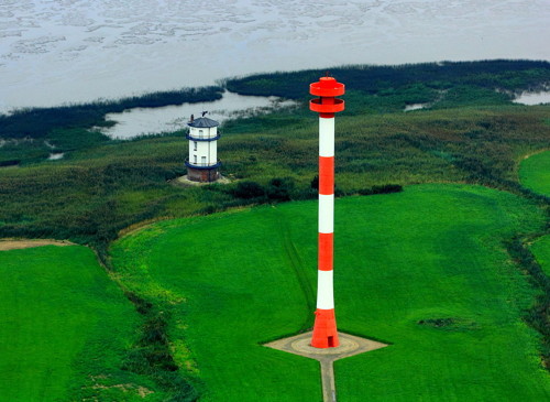
1979. Active; focal plane 54 m (177 ft); white light 4 s on, 4 s off, synchronized with the front light. 56 m (184 ft) round cylindrical concrete tower with double gallery forming a cylindrical topmark. Lighthouse painted with red and white horizontal bands. Walter Rademacher's aerial view is at right, Trabas has a closeup by Wolfgang Warncke, Werning has a fine photo, Kirsten Sander has a 2021 photo, a 2022 photo is available, and Google has a satellite view. This is the rear light of a major range guiding ships up the Elbe; its light reaches some 37 km (23 mi) back to Cuxhaven. Located quite close to the old lighthouse. Site open, tower closed. Operator: WSA Elbe-Nordsee. ARLHS FED-033; DE 309801; Admiralty B1412.1; NGA 10524.
*** Balje (1)
1904. Inactive since 1979. 17 m (56 ft) round cylindrical stone tower, incorporating keeper's quarters, with upper and lower galleries. Lighthouse painted white; conical roof is gray. Walter Rademacher's aerial view is at right, Werning has a fine page for the lighthouse, Günther Heyde has a photo, a 2022 photo is available, the lighthouse appears in Warncke's photo of the Balje Oberfeuer, Huelse has a historic postcard view, and Google has a satellite view. The area is a bird sanctuary (Vogelschutzgebiet), and the lighthouse now houses the sanctuary's ranger station. Located on the south bank of the Elbemündung (mouth of the Elbe), off the coastal road about 10 km (6 mi) northwest of the town of Balje. Site open, tower open Tuesday. Wednesday, Thursday, Saturday and Sunday during the summer. Owner/site manager: Vogelschutzgebiet Hullen. . ARLHS FED-034.
Balje Lights
1904 Balje Light and 1979 Balje Oberfeuer, Balje, September 2011
Wikimedia Creative Commons photo by Walter Rademacher

Drochtersen (Krautsand) Area Lighthouses
* Krautsand Oberfeuer
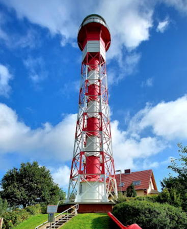
1908. Active; focal plane 35 m (115 ft); white light 4 s on, 4 s off, synchronized with the front light. 36 m (118 ft) hexagonal skeletal tower with a large circular lantern and gallery, enclosed 2-story watch room, and central cylinder, painted with red and white horizontal bands. Adjoining 1-1/2 story keeper's house. Heike Thielke's photo is at right, Werning has a good photo, Hartmann has a page for the range lighthouses, Leuchtturm-Atlas also has a page for the range lights, Trabas also has an excellent photo by Wolfgang Warncke of this historic lighthouse, Werner Pick has a 2017 photo, Silas Menter has a 2022 drone view, Huelse has a historic postcard view, and Google has a satellite view. This is the rear light of a downstream (westbound) range. The lighthouse, a sibling of the Grünendeich Oberfeuer, was extensively restored in 1988, and the original Fresnel lens was replaced with a modern range optic. Located 920 m (0.57 mi) northwest of the front light at Krautsand. Site open, tower closed. Operator:WSA Elbe-Nordsee. ARLHS FED-133; DE 310761; Admiralty B1482.1.
* Krautsand Unterfeuer (2)
1978 (station established 1901). Active; focal plane 20 m (66 ft); white light 4 s on, 4 s off, synchronized with the rear light. 20 m (66 ft) round cylindrical tower with lantern and gallery, painted with red and white horizontal bands. Hartmann has a page for the range lighthouses, Leuchtturm-Atlas also has a page for the range lights, Werning has a great photo, Trabas has a closeup by Capt. Peter, P.C. Ziesch has another closeup, and Google has a 2022 street view and a satellite view. The original lighthouse, a hexagonal stone tower seen in a 1951 photo and Huelse's postcard view, was demolished in 1978 to make way for strengthening the dike along the riverbank. Located just behind the dike on the southwest bank of the Elbe at Krautsand. Parking is available at the lighthouse. Site open, tower closed. Operator: WSA Elbe-Nordsee. ARLHS FED-132; DE 310760; Admiralty B1482.
* Ruthensand Unterfeuer
1955. Active; focal plane 15 m (49 ft); white light 2 s on, 2 s off, synchronized with the rear light; also a directional light, white, red, or green, occulting once every 6 s. 15 m (49 ft) round cylindrical tower with lantern and gallery, painted red with a white horizontal band. Hartmann has a page for the range lighthouses, Leuchtturm-Atlas also has a page for the range lights, Werning has a good photo, Trabas has Capt. Peter's closeup, and Google has a satellite view and a distant street view. This is an upsteam (eastbound) range. Located 1000 m (0.6 mi) north of the rear light, on the south bank of the Elbe at Ruthenstrom east of Drochtersen. Site and tower closed, but the lighthouse is easily seen from the road. Operator: WSA Elbe-Nordsee. ARLHS FED-202; DE 310700 (range light) and 310701 (directional light); Admiralty B1474; NGA 10575.

Krautsand Oberfeuer, Drochtersen, September 2021
Google Maps photo by Heike Thielke
* Ruthensand Oberfeuer
1955. Active; focal plane 30 m (98 ft); white light 2 s on, 2 s off, synchronized with the front light. 30 m (98 ft) round cylindrical tower with lantern and gallery, painted with red and white horizontal bands. Hartmann has a page for the range lighthouses, Leuchtturm-Atlas also has a page for the range lights, Trabas has Capt. Peter's photo and Google has a satellite view. Located in a pasture on the south bank of the Elbe about 2.5 km 1.5 mi) east of Drochtersen. Site and tower closed, but the lighthouse is easily seen from the road. Operator:WSA Elbe-Nordsee. ARLHS FED-203; DE 310702; Admiralty B1474.1; NGA 10575.1.

Stade Area Lighthouses
Bützflethersand Oberfeuer (2)
1970 (station established 1898). Active; focal plane 33 m (108 ft); white light 2 s on, 2 s off, synchronized with the front light; also a directional light, white, red, or green flash every 6 s. 31 m (102 ft) round cylindrical tower with lantern and funnel-shaped topmark, mounted on a concrete base, painted with red and white horizontal bands. Werning has an excellent photo, Trabas has a photo by Ulrich Bode, and Google has a satellite view. This range guides downstream (westbound) traffic, but the directional light guides upstream (eastbound) traffic. An image of the original lighthouse is available. Located beside a riverside highway (Bützflether Industriestraße) 610 m (670 ft) north of the front light, near a large industrial complex. Site and tower closed. Operator:WSA Elbe-Nordsee. ARLHS FED-063; DE 311181; Admiralty B1524.1.
Bützflethersand Unterfeuer (2)
1970 (station established 1898). Active; focal plane 20 m (66 ft); white light 2 s on, 2 s off, synchronized with the rear light. 20 m (66 ft) round cylindrical tower with lantern and funnel-shaped topmark, mounted on a concrete base, painted with red and white horizontal bands. Werning has a good photo, Trabas has a photo, Bernd Tschackert has a 2018 photo, Andreas Köhler has a 2019 photo, and Google has a satellite view. An image of the original lighthouse is available. Located at the end of a short groin projecting from the southwest bank of the Elbe at Stadersand, about 400 m (1/4 mi) north of the Stadersand Unterfeuer. Site and tower closed. Operator:WSA Elbe-Nordsee. ARLHS FED-062; DE 311180; Admiralty B1524.
* Stadersand Unterfeuer (2)
1958 (station established 1897). Active; focal plane 20 m (66 ft); white light 4 s on, 4 s off, synchronized with the rear light. 22 m (72 ft) round cylindrical tower with lantern and gallery, mounted on a concrete base, painted with red and white horizontal bands. A photo is at right, Werning has a good photo, Trabas has a closeup by Ulrich Bode, G. Baetje has a drone view, and Google has a satellite view. Huelse has a historic postcard view of the original lighthouse. This range guides upstream (eastbound) traffic. Located at the edge of the river 785 m (1/2 mi) north of the rear light. Site open, tower closed. Operator:WSA Elbe-Nordsee. ARLHS FED-227; DE 310900; Admiralty B1522.
Stadersand Oberfeuer (2)
1958 (station established 1897). Active; focal plane 40 m (131 ft); white light 4 s on, 4 s off, synchronized with the front light. 38 m (125 ft) round cylindrical tower with lantern and gallery, painted with red and white horizontal bands. Werning has a good photo, Trabas has a photo, Anke and Jens have a page with photos, and Google has a satellite view and a very distant street view. Located in the deactivated Stade Nuclear Power Plant at Stadersand on the southwest bank of the Elbe about 10 km (6 mi) northeast of Stade. Site and tower closed. Operator:WSA Elbe-Nordsee. ARLHS FED-228; DE 310901; Admiralty B1522.1.
Stadersand Unterfeuer
Stadersand Unterfeuer, Bützfleth, March 2010
Wikimedia Creative Commons photo by Morn the Gorn
* Twielenfleth (2) (relocated)
1972 (relocated here in 1984, this station established 1893). Active; focal plane 20 m (66 ft); directional light, white, red, or green light, depending on direction, occulting once every 6 s. 15 m (49 ft) round cylindrical fiberglass tower with flared top, lantern and gallery, painted with black and white horizontal bands. Werning has a fine photo, Trabas has a closeup by Ulrich Bode, Bernhard Maas has a 2021 photo, Christian Nitz has a good street view, and Google has a satellite view. This light guides upstream (eastbound) traffic. It was originally installed as the Kahlersand lighthouse south of the Elbe port in Stade. In 1984 it was relocated to replace the original Twielenfleth Light with a leading light. Located in front of the dike on the south bank of the Elbe at Twielenfleth, only a few steps from the older light. Site open, tower closed. Operator:WSA Elbe-Nordsee. ARLHS FED-242; DE 311200; Admiralty B1532.
* Twielenfleth (1) (relocated)
1893. Inactive since 1984. 7 m (23 ft) square cylindrical tower with lantern and gallery mounted on a short, square skeletal tower. Lighthouse painted white with black trim; skeletal section and lantern roof are black. Werning has a good photo, Wikipedia has a photo, a 2022 photo is available, Christian Nitz has a good street view, and Google has a satellite view. Huelse has a historic postcard view of this lighthouse, which is a rare survivor of its class. It appears to have been designed so that it could be moved easily if the range line changed. It was deactivated in 1984 when the rear light became a leading light; it was then relocated a short distance below the dike The tower houses a small museum, open by appointment. Located behind the dike on the south bank of the Elbe at Twielenfleth, about 16 km (9 mi) east of Stade. Site open, tower closed. Owner/site manager: Municipality of Hollern-Twielenfleth. ARLHS FED-243.; ex-Admiralty B1532.

Lühe Area Lighthouses
* Grünendeich (Lühe Oberfeuer)
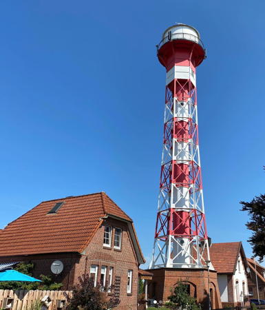
1900 (J. H. Hartje). Active; focal plane 35.5 m (117 ft); white light 2 s on, 2 s off, synchronized with the front light. 39 m (129 ft) hexagonal skeletal tower with a large circular lantern and gallery, enclosed 2-story watch room, and central cylinder, mounted on a 1-story hexagonal brick base. Lighthouse painted with red and white horizontal bands, lantern white with a black roof, gallery railing black. A 2020 photo is at right, Reinhard Schuldt has a good 2010 photo, Werning has a good photo, Trabas has a photo by Ulrich Bode, Dierck Gutschendies has a 2017 photo, and Google has a 2022 street view and a satellite view. The lighthouse was restored in 1994. Located on the Kirchenstieg near the Minneweg in Grünendeich, 1546 m (1 mi) west of the front light. Site open, tower closed. Operator:WSA Elbe-Nordsee. . ARLHS FED-097; DE 311281; Admiralty B1540.1.
* Lühe Unterfeuer (2)
1970 (station established 1900). Active; focal plane 16 m (52 ft); white light 2 s on, 2 s off, synchronized with the rear light. 12 m (40 ft) round cylindrical tower with a large round lantern and gallery, painted with red and white horizontal bands. Anett Jauernig's photo is at right, Werning has a good photo, Trabas has a closeup, Christian Kruse has a street view, and Google has a satellite view. The Lühe range is a downstream (westbound) range. Located on the south bank of the Elbe very close to the west side of the mouth of the Lühe River. Site open, tower closed. Operator:WSA Elbe-Nordsee. ARLHS FED-149; DE 311280; Admiralty B1540.
* Lühe Unterfeuer (1)
1900. Inactive since 1970. Approx. 12 m (40 ft) square tower rising from one corner of 1-story keeper's house. Lantern removed. Building painted white with red-brown trim. Werning has an excellent photo and Google has a 2022 street view and a satellite view. Huelse has a historic postcard view of this lighthouse. Sibling of the Mielstack lighthouse (see below). The lighthouse was sold and is occupied as a private residence. Located in Lühe, just west of the mouth of the Lühe River. Site open, tower closed. Owner/site manager: private. ARLHS FED-306.
Somfletherwisch (Mielstack) Unterfeuer (2)
2009 (?). Active; focal plane 19 m (62 ft); white light 4 s on, 4 s off, synchronized with the rear light. 22 m (72 ft) round cylindrical tower with a large round lantern and gallery, painted with red and white horizontal bands. Lantern roof is black. Trabas has Helmut Seger's photo, Heinz Petersen has a 2018 photo, and Google has a satellite view and a street view of the top of the tower over the dike. Located on the south bank of the Elbe about 200 m (220 yd) west of the older lighthouse (next entry). Site open, tower closed. Operator: WSA Elbe-Nordsee. DE 311240; Admiralty B1534.
* Mielstack Unterfeuer (1)
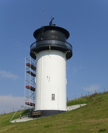
1907. Inactive since about 2009. 16 m (52 ft) square tower with round lantern and gallery rising from one corner of a 1-story keeper's house. Lighthouse painted white with brown trim and a brown tile roof; lantern's conical roof is black. Margret Pirzer's photo is at the top of this page, Werner Hansel has a nice 2018 photo, Stephan Schwan has a 2021 photo, Werning has a good photo, Huelse has a historic postcard view, and Google has a 2022 street view and a satellite view. This very attractive lighthouse is located on the main riverbank street in the Mielstack neighborhood of Lühe, 600 m (0.4 mi) southeast of the mouth of the Lühe River. Site open, tower closed. Operator: WSA Elbe-Nordsee. ARLHS FED-153.
* Somfletherwisch (Mielstack Oberfeuer)
1907. Active; focal plane 32 m (105 ft); white light 4 s on, 4 s off, synchronized with the front light. 35 m (115 ft) hexagonal skeletal tower with a large circular lantern and gallery, enclosed 2-story watch room, and central cylinder. Lighthouse painted with red and white horizontal bands, lantern white with a black roof, gallery railing black. Trabas has an excellent photo by Manfred Schüler, Werning has a good photo, Philipp Baar has a street view, and Google has a satellite view. Sibling of the Grünendeich Oberfeuer (see above). This is an upstream range. Located at Wisch, 750 m (1/2 mi) southeast of the front light and about 2 km (1.2 mi) southeast of Lühe on the south bank of the Elbe. Site open, tower closed. Operator:WSA Elbe-Nordsee. ARLHS FED-224; DE 311241; Admiralty B1534.1.


Grünendeich Oberfeuer, Lühe, August 2020
Instagram photo by im_herzen_nordlicht
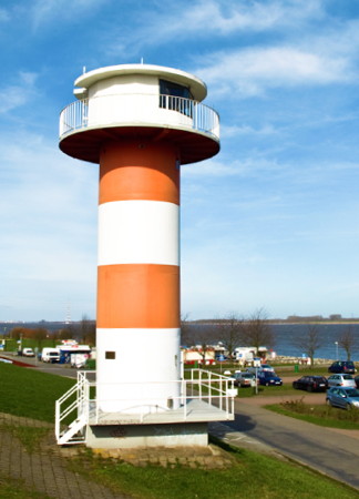
Lühe Unterfeuer
Lühe Unterfeuer, Lühe, November 2009
Flickr Creative Commons photo by Anett Jauernig

Information available on lost lighthouses:

  • Bassenfleth Unterfeuer (1897-1959), South bank, Stade area. This range was discontinued and the lighthouses demolished.
  • Bassenfleth Oberfeuer (1897-1959), South bank, Stade area. Huelse has a postcard view.
  • Brunshausen (1897-1930), South bank near Stadersand. The fate of this light is not known.
  • Neufeld (1897-1980), South bank just above Cuxhaven. Huelse has a historic postcard view. The lighthouse was deactivated in 1980 and later demolished. ARLHS FED-161.
  • Neuwerk Unterfeuer (1815-1885), Neuwerk Island. The light was demolished long ago.
  • Osteriff (1934-?). This tower was a sibling of the three Pagensand lighthouses of the same era (see the Hamburg Area page). Originally located off the entrance to the Oste River from the Elbe near Otterndorf, the lighthouse was relocated to stand outside the headquarters of then-WSA Cuxhaven, (now WSA Elbe-Nordsee) near Alte Liebe. However, the 2016 street view by Oliver Buschjost does not show the lighthouse and Andreas Köhler has confirmed that it has been removed. ARLHS FED-308.

Notable faux lighthouses:

Adjoining pages: North: North Frisia | East: Hamburg Area | South: Bremerhaven Area

Return to the Lighthouse Directory index | Ratings key

Posted March 30, 2005. Checked and revised January 15, 2024. Lighthouses: 37; lightships: 1. Site copyright 2024 Russ Rowlett and the University of North Carolina at Chapel Hill.