Lighthouses of Denmark: Bornholm

The Kingdom of Denmark (Danmark in Danish), located at the mouth of the Baltic Sea, includes the north-pointing peninsula of Jylland (Jutland) in the west and a large number of islands to the east. The capital, Copenhagen, is on the island of Sjælland. Other major Danish islands include Fyn (between Sjælland and Jylland), Lolland and Falster (south of Sjælland) and Bornholm (farther east in the Baltic). The Skaggerak is a sound separating Jylland from Norway to the northwest, while the Kattegat separates Jylland from Sweden to the northeast.

The island of Bornholm is roughly 35 km (22 mi) long and 15 km (9 mi) wide, located in the southwestern Baltic Sea (called the Østersøen, East Sea, in Denmark). Although the island is closer to Sweden, Poland, and Germany than it is to the rest of Denmark it has been part of the Danish kingdom for most of its history. Because of its strategic location it has been involved in many wars. During World War II it was occupied by German troops from 1940 to 1945 and then by Soviet troops until April 1946, when it was restored to Danish control. The island is accessible by air or by ferries from Køge in Sjælland, Ystad in Sweden, Sassnitz in Germany, or Swinoujscie in Poland.

Denmark is divided into five regions. Bornholm is administered as part of the Hovedstaden, or Capital Region, which also includes the metropolitan area of Copenhagen..

The Danish word for a lighthouse is fyr or fyrtårn. The front light of a range is the forfyr and the rear light is the bagfyr. Næs is a cape, odde a narrow promontory or isthmus, ø is an island, bugt is a bay, rev is a reef, fjord is an inlet, and havn is a harbor.

Danish aids to navigation are managed by the Danish Maritime Authority (Søfartsstyrelsen).

ARLHS numbers are from the ARLHS World List of Lights. DFL numbers are from the Dansk Fyrliste (Danish Light List). Admiralty numbers are from volume C of the Admiralty List of Lights & Fog Signals. U.S. NGA List numbers are from Publication 116.

General Sources
Danske Fyrtårne
A comprehensive site on Danish lighthouses by Ole Henrik Lemvigh, with many photos; the text is entirely in Danish.
Online List of Lights - Bornholm
Photos by various photographers posted by Alexander Trabas.
Leuchtturmseiten von Anke und Jens - Denmark
Photos of more than 100 Danish lighthouses, with notes in English.
Dänische Leuchttürme
Photos of more than 175 Danish lighthouses posted by Klaus Huelse.
Lighthouses in Denmark
Photos by various photographers available from Wikimedia.
Lighthouses in Denmark
Aerial photos posted by Marinas.com.
Dänische Leuchttürme auf historischen Postkarten
Historic postcard views posted by Klaus Huelse.
Dansk Fyrliste 2022
Official Danish light list (in .pdf format); the list also includes lights of Greenland and Faroes.
OpenSeaMap
Navigational chart information for Bornholm.
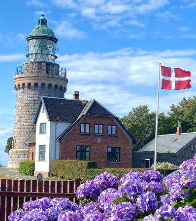

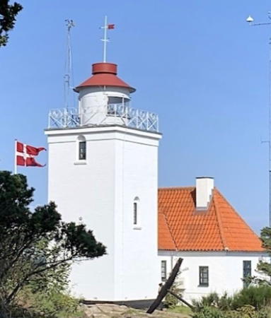
Hammeren Light, Sandvik, August 2023
Instagram photo by Marie Kirsttine
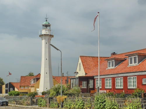
Bornholm West Coast Lighthouses
Rønne Havn South Jetty (Outer Breakwater)
Date unknown. Active; focal plane 11 m (36 ft); green flash every 3 s. 5 m (16 ft) square concrete tower rising from a 1-story concrete equipment building. Tower and equipment building painted green. Trabas has a photo and Google has a satellite view and a very distant street view across the harbor. Located at the end of the south outer breakwater at Rønne. Site status unknown. DFL-6203; Admiralty C2484; NGA 5706.
Rønne Havn South (Inner) Breakwater
Date unknown. Active; focal plane 9 m (30 ft); continuous green light. 7 m (23 ft) square stone tower painted green. Trabas has a photo, Bent Sonne Pedersen has a photo, Jens Pihl has the view from a ferry, and Google has a satellite view and a distant street view across the harbor. Located at the end of the south inner breakwater at Rønne. Site status unknown. DFL-6208; Admiralty C2486; NGA 5700.
[Rønne Havn North (Inner) Breakwater]
Date unknown. Active; focal plane 8 m (26 ft); continuous red light. 3 m (10 ft) square concrete tower painted red. Trabas has a photo, Helge Stuve has a photo, and Google has a satellite view and a distant street view across the harbor. Located at the end of the south inner breakwater at Rønne. Site status unknown. DFL-6206; Admiralty C2488; NGA 5704.
* Rønne Bagfyr (2)
1880 (station established 1846). Inactive since 1989(?). 18 m (59 ft) tapered octagonal cast iron tower with lantern and gallery, painted white; lantern dome painted green. Per Allan Nielsen's photo is at right, Łukasz Nowak has a photo, Jens Pihl has a 2021 photo, Thomas Roland has a lovely view from the harbor, Huelse has a historic postcard view, and Google has a street view and a satellite view. This historic tower was fabricated in Bornholm by the firm of H. Wichmann & Co. The lighthouse was restored in 2000 and has been maintained in good condition. The modern front light (Admiralty C2483; NGA 5716.5) is on a 13 m (43 ft) skeletal mast, and the rear light (Admiralty C2483.1; NGA 5716.51) is on a 12 m (39 ft) pole. Located about two blocks behind the waterfront in Rønne. Site open, tower closed. . ARLHS DEN-144; ex-Admiralty C2482.

Rønne Bagfyr, Rønne, June 2020
Google Maps photo by Per Allan Nielsen
* Rønne Havn (Inner Mole, Forfyr)
Date unknown (1930?). Active; focal plane 11 m (36 ft); continuous red light. 9 m (30 ft) round granite tower with a small lantern and gallery. Lighthouse unpainted; the lantern is greenish metallic. Huelse has a photo and a historic postcard view, Trabas has Rainer Arndt's photo, a 2006 closeup is available, Ejlif Pedersen has a closeup, and Google has a street view and a satellite view. This light was originally the front light of the entrance range, but the range was discontinued in the 1980s when the harbor was extended with outer breakwaters and a realigned entrance channel. Located at the end of the north inner breakwater at the Harbor of Rønne, the terminal for ferries arriving in Bornholm. Accessible by walking the mole. Site open, tower closed. ARLHS DEN-143; DFL-6210; Admiralty C2489; NGA 5705.
* Hammerhavn (Hammerhavnen Øst)
1893. Active; focal plane 12 m (39 ft); white, red or green light depending on direction, 1 s on, 1 s off. 4 m (13 ft) square wood tower; the light is shown through a rectangular window. Lighthouse painted white. Huelse has a closeup photo and Trabas has a good view from the water, but the light is hidden by vegetation in Google's satellite view. Hammerhavn is a small boat harbor near Hammerodde. This directional light guides vessels through the narrow harbor entrance. Located at the end of the Hammersøvej about 1.6 km (1 mi) southwest of Sandvig. Site open, tower closed. DFL-6260; Admiralty C2504; NGA 5656.
**** Hammeren (Hammerfyr)
1872. Inactive officially since 1990; a decorative white light has been displayed since 2011. 21 m (69 ft) round granite tower with lantern and gallery attached to a 1-1/2 story brick keeper's house. Original 1st order Fresnel lens. The tower is unpainted; lantern dome is unpainted greenish metallic. Marie Kirsttine's 2023 photo is at the top of this page, Lemvigh has a page for the station, Wikipedia also has a page, Anke and Jens have a page with photos, Huelse has a closeup photo and a historic postcard view, Barbro Sveninge has a 2016 photo, a 2021 photo and a drone view are available, Piotr Olenkowicz has a street view, and Google has a satellite view. This lighthouse replaced the Stejlebjerg Fyr, established in 1802, which was closer to Hammerodde. The focal plane height was 91 m (299 ft), sometimes too high for the light to be seen in foggy conditions, so the Hammerodde lighthouse (next entry) was added as a supplement. Following deactivation the lighthouse was trsnsferred to the Naturstyrelsen (Danish Nature Agency) in 1992. Located at the end of the Fyrvej about 2.5 km (1.5 mi) west of Sandvig. Site open, tower open daily except during the winter. Owner: Naturstyrelsen. Site manager: Hammerfyr . ARLHS DEN-012.
* Hammerodde
1895. Active; focal plane 21 m (69 ft); two white flashes every 10 s. 12 m (39 ft) square cylindrical masonry tower with lantern and gallery attached to a 1-1/2 story masonry keeper's house. Lighthouse painted white, lantern gray with a red dome. This is a staffed station serving to control all the other lighthouses of Bornholm. Carina Bengtsson's 2023 photo is at right, Lemvigh has a good page for the lighthouse, Hartmut Wolter has a 2021 photo, Huelse has a closeup photo and a historic postcard view, Trabas has a good photo, Marinas.com has aerial photos, Krzysztof Śmiałek has a street view, and Google has a satellite view. This light marks the northwestern corner of Bornholm. It was built because the Hammeren lighthouse (previous entry) was sometimes too high for its light to be seen in foggy conditions. Located on the cape, about 800 m (1/2 mi) north of Sandvig. Site open, tower closed. . ARLHS DEN-145; DFL-6010; Admiralty C2508; NGA 5844.

Hammerodde Light, Sandvik, June 2023
Instagram photo by Carina Bengtsson

Bornholm East Coast Lighthouses
* Svaneke Havn
Date unknown. Active; focal plane 6 m (20 ft); white, red or green light depending on direction, 2 s on, 2 s off. 4 m (13 ft) square wood tower; the light is shown through a rectangular window. Trabas has a closeup photo, Andreas Köhler has a 2021 closeup, Huelse also has a photo, and Google has a street view and a satellite view. Located on the waterfront in Svaneke, just south of the harbor. Site open, tower closed. ARLHS DEN-147; DFL-6098; Admiralty C2532; NGA 5776.
* Svaneke (Sandkås Odde)
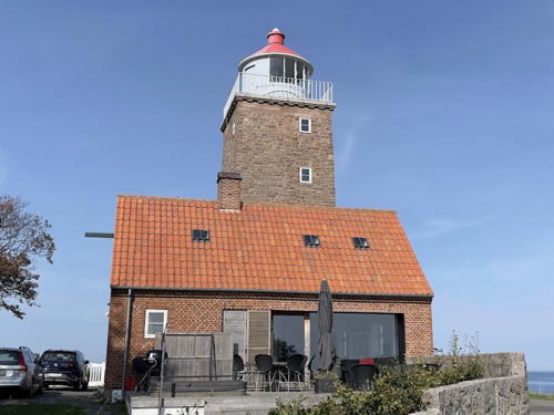
1920. Inactive since 2010. 18 m (59 ft) square stone tower with lantern and gallery, attached to a 2-1/2 story brick keeper's house. The tower is unpainted; lantern dome painted red. Tom David Lindved has the 2021 photo at right, Anke and Jens have a page for the lighthouse, a 2007 photo is available, Huelse has a photo and a historic postcard view, Marinas.com has aerial photos, and Google has a street view and a satellite view. This lighthouse marks the northeastern corner of Bornholm. It has been renovated and is available for vacation rental. Located at the end of the Skovgade at the eastern end of Sveneke. Site open, tower closed. Owner: unknown. Site manager: Svaneke Fyr . ARLHS DEN-146; ex-DFL-6085; ex-Admiralty C2530; ex-NGA 5768.
* Nexø (Neksø) Range Rear
Date unknown. Active; focal plane 12 m (39 ft); continuous green light. Mast mounted on the roof of a building. Trabas has a photo and Google has a street view but the mast is inconspicuous in Google's satellite view. Nexø, on the east coast of Bornholm, is the island's principal fishing port and second largest town. The front light of the range is on a skeletal mast. Located atop the Kop & Kande kitchen supply store in downtown Nexø. Site open, tower closed. DFL-6120a; Admiralty C2546.1; NGA 5756.

Svaneke Light, Svaneke, September 2021
Google Maps photo by Tom David Lindved
**** Dueodde
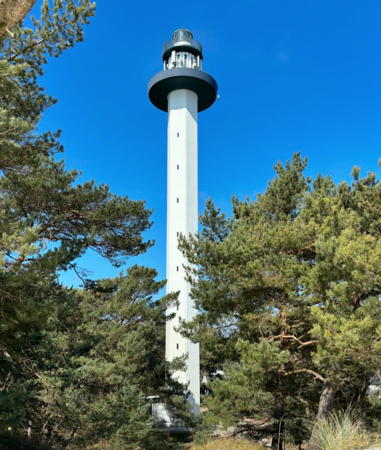
1962. Active; focal plane 48 m (157 ft); three white flashes every 10 s. 47 m (154 ft) hexagonal cylindrical concrete tower with lantern and double gallery. Tower painted white; galleries painted dark blue; lantern dome is gray metallic. The Fresnel lens (1886) of the Dueodde Nord lighthouse was transferred to this tower. H.H. Franziska's 2024 photo is at right, Jan Kronsell has a photo, Uwe Koschorek has a 2020 photo, Lemvigh has a page for the lighthouse, Trabas has a closeup, Huelse has a photo, Marinas.com has aerial photos, and Google has a street view and a satellite view. This is Denmark's tallest lighthouse and one of the most important lighthouses of the Baltic Sea. Located on the southeastern tip of Bornholm, a short distance seaward of the Dueodde Syd lighthouse. Site open; tower open for climbing during the afternoon daily. . ARLHS DEN-149; DFL-6150; Admiralty C2550; NGA 5732.
* Dueodde Syd
1880. Inactive since 1962. 15 m (49 ft) hexagonal masonry tower rising from the seaward side of a 2-story masonry keeper's house. Entire lighthouse painted white. After the lighthouse was deactivated, the original lantern was removed and replaced with a large observation room, destroying the architectural integrity of the historic building. Lemvigh has a page for the station, Andreas Köhler has a 2021 photo, Huelse has a closeup photo and a historic postcard view showing the original form of the lighthouse, and Google has a street view and a satellite view. After deactivation the building was used as a marine traffic monitoring station, but it appears abandoned today. Located at the end of the Fyrvejen in Dueodde, not far from the beach and the modern lighthouse. Site open, tower closed. ARLHS DEN-150.
* Dueodde Nord
1880. Inactive since 1962. Approx. 32 m (105 ft) round granite tower with gallery, attached to a 1-story keeper's house. The lantern has been removed. Two additional 1-1/2 story keeper's houses nearby. The lighthouse is unpainted dark gray stone. Lemvigh has a page for the station, Klaus Selicke has a 2021 photo, Huelse has a good photo and a historic postcard view, and Google has a street view and a satellite view. One of two lighthouses originally built to mark Dueodde, the southern tip of Bornholm; two were built because a dispute over the best location for the light could not be resolved. After deactivation, the light station was transferred to the Danish Navy; more recently the station has been redeveloped as a museum of the Cold War. The complex includes a 70 m (230 ft) observation tower. Located on the Strandmarksvejen in Dueodde about 1200 m (3/4 mi) north of the cape. Site open, tower closed. Site manager: Bornholmertarnet. ARLHS DEN-148.
* Bakkerne Forfyr
Date unknown. Active; focal plane 6 m (20 ft); continuous white light. 4.5 m (15 ft) mast attached to a small 1-story building. Building painted white. Trabas has Andreas Köhler's photo and Google has a street view and a satellite view. The rear light is on a short mast. Located at Bakkerne, a tiny port about 7 km (4 mi) west of Dueodde. Site open, tower closed. DFL-6160b; Admiralty C2552.

Dueodde Light, Snogebæk, April 2024
Instagram photo by H.H. Franziska

Christiansø Lighthouses
Christiansø is the largest of the three small Ertholmene Islands located in the Baltic Sea about 16 km (10 mi) north northeast of Bølshavn, Bornholm. The total population of the islands is less than 100, but they are popular as a summer resort and yacht harbor. Denmark fortified the islands in 1684. Ferry transportation is available from Bornholm.
*** Christiansø
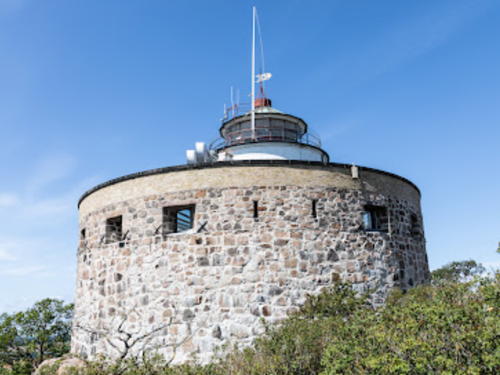
1805 (Westh and Poul Løwvenørn). Active; focal plane 29 m (95 ft); white flash every 5 s. 16 m (52 ft) round tower with lantern and gallery mounted within a circular stone fortification known as the Store Tårn (big tower). The fort is unpainted, tower painted white; lantern dome is greenish metallic. The Fresnel lens now in use here was transferred from the Hyllekrog lighthouse south of Lolland in 1971; the original drum-style Fresnel lens is on display at the Nationalmuseet in Copenhagen. H. Nielsen's 2023 photo is at right, Tom David Lindved has a 2021 photo, Anke and Jens have a good page for the lighthouse, Trabas has a photo by Ronald Wöhrn, Huelse has a closeup photo and a historic postcard view, Marinas.com has aerial photos, Damian Klimowicz has a street view, and Google has a satellite view. This was the first Danish lighthouse to display a flashing light. Built in 1684 and manned until 1855, the fortress has been renovated as a local history museum. Site open, museum open daily mid April through mid October, tower closed. Site manager: Søfæstning Christiansø. ARLHS DEN-004; DFL-6270; Admiralty C2556; NGA 5848.
* Fredericksø (Christiansø Havn)
Date unknown. Active; focal plane 7 m (23 ft); white, red or green light depending on direction, 2 s on, 2 s off. 4 m (13 ft) square wood tower; the light is shown through a rectangular window. Lighthouse painted white with one red horizontal band. Trabas has Ronald Wöhrn's closeup photo, Huelse has a photo, a 2018 photo is available, Aki Haugstad has a street view, and Google has a satellite view. Fredericksø is a smaller island just west of Christiansø, to which it is connected by a bridge. This light guides vessels entering the harbor from the north. Located on the Fredericksø waterfront just north of the bridge. Site open, tower closed. DFL-6280; Admiralty C2558; NGA 5856.

Christiansø Light, Christiansø, July 2023
Google Maps photo by H. Nielsen

Information available on lost lighthouses:

Notable faux lighthouses:

Adjoining pages: Southeast: Poland Baltic Coast | Southwest: Germany Vorpommern | West: Sjælland | Northwest: Sweden Blekinge

Return to the Lighthouse Directory index | Ratings key

Posted February 12, 2007. Checked and revised May 2, 2024. Lighthouses: 16. Site copyright 2024 Russ Rowlett and the University of North Carolina at Chapel Hill.