Lighthouses of Germany: Vorpommern-Rügen

The Federal Republic of Germany (Bundesrepublik Deutschland in German) occupies a central location in northern Europe with two coastlines, one facing northwest on the North Sea and the other facing northeast on the Baltic Sea. The country's history is long and complex. The large number of historically independent German regions came together in 1871 to form the German Empire. The Empire became a republic after World War I (1914-18). After World War II (1939-45) Germany was divided into two countries, the German Federal Republic in the west, usually called West Germany, and the Communist-led German Democratic Republic in the east, usually called East Germany. After the Communist government collapsed the Federal Republic reunified the nation in October 1990.

Germany is a federation of 16 member states called Bundesländer, and the states are divided into districts (Kreise). This page lists lighthouses of the district of Vorpommern-Rügen, part of the state of Mecklenburg-Vorpommern. Before the creation of the German Empire in 1871 all of this region was part of the Kingdom of Prussia. From the end of World War II until the reunification of Germany in 1991 it was part of the German Democratic Republic (East Germany). Mecklenburg includes the western portion of the East German coast (the Wismar, Warnemünde, and Rostock areas), while Vorpommern (Lower or Western Pomerania) includes the eastern section from the Stralsund area to the Polish border. The district of Vorpommern-Rügen includes the large island of Rügen and the neighbring mainland.

Interest in lighthouses is strong in Germany and most of the towers are in good condition. A federal law provides blanket protection to historic lighthouses. There is concern, however, that many of the lights may be deactivated in the coming years as navigators depend less and less on them.

In German, a lighthouse is a Leuchtturm ("light tower"), plural Leuchttürme. The front light of a range is the Unterfeuer and the rear light is the Oberfeuer. Modern range lighthouses are crowned by a topmark: a large, distinctive structure that serves to mark the range clearly in the daytime. In German Insel is an island, Riff is a reef, Kap is a cape, Bucht is a bay, and Hafen is a harbor. The Baltic Sea is known in Germany as the Ostsee (East Sea).

Lighthouses in Germany are operated by the regional harbor authority, called the WSA (Wasserstraßen- und Schifffahrtsamt). Recently the two WSA's for the Baltic coast, WSA Lübeck and WSA Stralsund, have been merged to form the WSA Ostsee. The WSA's are linked to and regulated by a federal agency, the Wasserstraßen- und Schifffahrtsverwaltung des Bundes (WSV).

ARLHS numbers are from the ARLHS World List of Lights. Admiralty numbers are from volume C of the Admiralty List of Lights & Fog Signals. U.S. NGA List numbers are from NGA Publication 116.
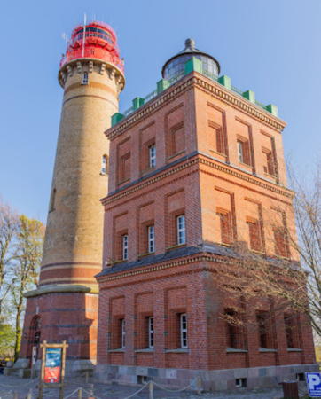

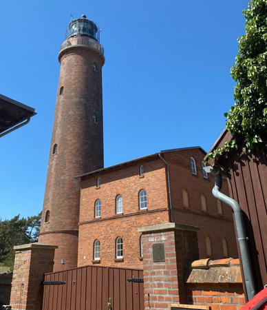
 Kap Arkona Lights, Rügen, May 2022
Google Maps photo by Jarosław Mrzygłód

General Sources
Online List of Lights - Germany - Baltic
Photos of German Baltic Sea lights posted by Alexander Trabas.
Leuchttürme und Leuchtfeuer an der Ostsee
Photos and information posted by Erich Hartmann, a contributor to the Online List of Lights.
Leuchtturm-Atlas
A large site with excellent photos and information on nearly all German lighthouses, maintained by Frank and Birgit Toussaint.
Leuchttürme.net - Deutschland
Outstanding photos by Malte Werning.
Leuchtturmseiten von Anke und Jens - Germany Baltic Sea
This site has photos and information on many of the lights.
Germany Lighthouses
Photos by Larry Myhre.
Lighthouses in Mecklenburg-Vorpommern
Photos by various photographers available from Wikimedia.
World of Lighthouses - Germany
Photos by various photographers available from Lightphotos.net.
Lighthouses in Germany
Aerial photos posted by Marinas.com.
Deutsche Leuchttürme/Feuerschiffe
Photos posted by Klause Huelse, who also has a page of historic postcard views.
Interessengemeinschaft Seezeichen e.V.
Germany's national lighthouse preservation organization.
GPSNauticalCharts
Navigation chart for Germany's Baltic coast.
Navionics Charts
Navigation chart for Germany's Baltic coast.


Dornbusch Light, Hiddensee, April 2024
Instagram photo by Rügen und Hiddensee

Darß Area Lighthouses
* #Wustrow (2)
1933 (light station established 1911; fog signal station established 1897). Inactive since 2014 and demolished in 2016. This was a 8 m (26 ft) square brick tower with gallery, rising from one corner of a 1-story generator house. Lantern removed and stored for possible future display. The tower was unpainted red brick; the lantern was painted white with a red roof. Werning has a photo and Leuchtturm-Atlas has a page with photos. Google has a satellite view of the former location. The original light was fastened to the chimney of the fog signal generator house. This light is in Fischland, a narrow, sandy barrier isthmus connecting the mainland to the Darß-Zingst peninsula. The government resisted placing a light here in addition to the Darßer Ort lighthouse, but gave in when so many ships kept wrecking on the beach in the area. In September 2013 a new light (focal plane 11 m (36 ft); white light, occulting three times every 12 s) was placed on a mast on the Wustrow pier. The historic lighthouse was deactivated in April 2014 and the lantern was removed to storage by WSA Stralsund. The buildings were demolished. Located just behind the beach near Ostseebad Wustrow, about 30 km (19 mi) southwest of Darßer Ort. Site open, tower closed. Operator: WSA Ostsee. ARLHS FED-267. Active pier light: DE 215940; Admiralty C1436; NGA 3512.
**** Darßer Ort
1848. Active; focal plane 33 m (108 ft); six white flashes, in a 4+2 pattern, every 22 s. 35 m (115 ft) round brick tower, unpainted, with lantern and gallery. 2-story keeper's house, painted white, and other light station buildings. Leo Mende's 2024 photo is at right, Hartmann has a page for the lighthouse, Werning has a photo, Trabas has a closeup by Stephan Hix, Wikimedia has a photo, Huelse has a historic postcard view, and Google has a street view and a satellite view. Darßer Ort is a sandy promontory with large dunes sheltering an unusual maritime forest. The lighthouse was restored in 1994. Opened to the public in 1995, this historic station has quickly become one of Germany's best known and most visited lighthouses. Following reunification the national park service restored the station and the Deutsches Meeresmuseum in Stralsund established an aquarium and nature museum, the Natureum Darßer Ort, in the keeper's house and other buildings. Most visitors also climb the tower for its spectacular view over the Baltic; in good weather the Danish island of Falster can be seen across the mouth of the Mecklenburger Bucht. Located on the point of Darßer Ort about 5 km (3 mi) west of Ostseebad Prerow. Site open, museum and tower open daily May through October and daily except Mondays and Tuesdays the rest of the year. Operator:WSA Ostsee. Site manager: Nationalpark Vorpommersche Boddenlandschaft (Leuchturm Darßer Ort ).ARLHS FED-070; DE 216000; Admiralty C1440; NGA 3516.

Darßer Ort Light, Darß, May 2024
Instagram photo by Leo Mende
* Zingst
2013. Active; focal plane about 14 m (46 ft); yellow flash every 4 s. 14 m (46 ft) post carrying a large round diving bell (Tauchgondol) that can be lowered on the post. Trabas has a photo by Capt. Peter Mosselberger, Karsten Bechstedt has a pier view, and Google has a satellite view. The diving bell is a tourist attraction, one of several such attractions Germany's Baltic coast. Located near the end of the pier at Zinnowitz, a resort town about 15 km (9 mi) southeast of Darßer Ort. Site and diving bell open. DE 216050; Admiralty C1439.9.

Barhöft Area Lighthouses
Zarrenzin Unterfeuer (Bock Oberfeuer) (2)
1940 (station established 1900). Active; focal plane 23 m (75 ft); white, red, or green light, depending on direction, occulting once every 6 s, synchronized with the Bock Unterfeuer and Zarrenzin Oberfeuer lights. 23 m (75 ft) square skeletal tower with lantern and gallery. Tower painted white, lantern and gallery painted red. Trabas has a view of the Bock range by Karl-Heinz Wellm, Hartmann has a page for the Zarrenzin Range, Rolf Frische Luft has a photo of the two Bock lights, and Google has a satellite view. The entrance to Stralsund from the north is through a narrow passage between the barrier islands of Bock and Hiddensee. The Zarrenzin range guides ships approaching Stralsund from the Baltic, while the Bock range guides ships leaving Stralsund. In addition to the range lights, this tower displays directional lights for nearby ships. Located on the north coast of Bock, an uninhabited island incorporated into the Vorpommersche national park. Accessible only by boat. Site open, tower closed. Operator: WSA Ostsee. Site manager: Nationalpark Vorpommersche Boddenlandschaft. DE 216280 (Zarrenzin Unterfeuer) and 216701 (Bock Oberfeuer); Admiralty C2576; NGA 5876.
Bock Unterfeuer (2)
1940 (station established 1910). Active; focal plane 12 m (39 ft); white light, occulting once every 6 s, synchronized with the rear light. 13 m (43 ft) square skeletal tower with lantern and gallery. Tower painted white, lantern and gallery painted red. Trabas has a good photo by Eckhard Meyer, Andreas Köhler has a 2021 photo, Hartmann has a page for the Bock Range, Rolf Frische Luft has a photo of the two Bock lights, and Google has a satellite view. Located on the south coast of Bock about 1100 m (0.7 mi) south southeast of the Oberfeuer. Accessible only by boat, but there is a good view of this light (across a narrow channel) from the waterfront of Barhöft on the mainland. Site open, tower closed. Operator: WSA Ostsee. Site manager: Nationalpark Vorpommersche Boddenlandschaft. DE 216700; Admiralty C2575.9; NGA 5872.
Zarrenzin Oberfeuer
1940. Active; focal plane 52 m (171 ft); white light, occulting once every 6 s, synchronized with the front light. 24 m square skeletal tower with square lantern and gallery. Tower painted with red and white horizontal bands; the lantern and gallery are red, but the lantern roof is white. Trabas has a photo, Hartmann has a page for the Zarrenzin Range, and Google has a satellite view. Located in a field on the mainland, at the high point of the Barhöft peninsula about halfway between Barhöft and Zarrenzin, 2.1 km (1.3 mi) south southwest of the front light. Site status unknown. Operator: WSA Ostsee. DE 216281; Admiralty C2576.1; NGA 5880.

Hiddensee Lighthouses
Hiddensee is a barrier island on the west side of Rügen; it is accessible by ferry from Schaprode on Rügen or from Stralsund. Private vehicles are prohibited on the island; visitor transportation is available on electric-powered buses or horse-drawn carriages.
* Gellen
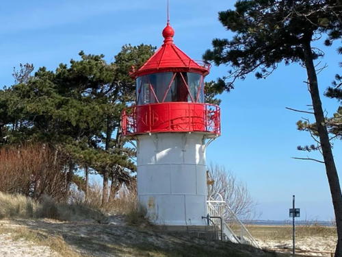
1905 (Julius Pintsch). Active; focal plane 10 m (33 ft); white, red, or green light, depending on direction, occulting twice every 10 s. 12 m (40 ft) round cylindrical cast iron tower with lantern and gallery, mounted on a stone base. 4th order Fresnel lens in use. Tower painted white, lantern and gallery red, lantern roof black. A 2024 photo is at right, Hartmann has a page for the lighthouse, Werning has a photo, Trabas has a nice closeup by Klaus Kern, Wikimedia has closeup, Stefan Bernsmann has a 2021 photo, Daniel Schumann has a street view, and Google has a satellite view. This small lighthouse is roughly midway along the narrow barrier island of Hiddensee. Located just behind the dunes a short distance south of the ferry terminal at Plogshagen. Site open, tower closed. Operator:WSA Ostsee. Site manager: Nationalpark Vorpommersche Boddenlandschaft (Leuchturm Gellen ). ARLHS FED-088; DE 216240; Admiralty C2586; NGA 5868.
*** Dornbusch
1888. Active; focal plane 95 m (312 ft); white light, 2.4 s on, 7.6 s off; a red sector is shown to the south southwest along the coast of Hiddensee. 28 m (92 ft) 12-sided masonry tower with lantern and gallery, painted white; lantern roof painted red. A 2024 photo is at the top of this page, Hartmann has a page for the lighthouse, Werning has a photo, Trabas has a closeup by Klaus Kern, Robert Rebmann has a 2021 photo, Michel Rothboeck has a street view, and Google has a satellite view. This handsome lighthouse is built on a high dune called Bakenberg (Beacon Hill); the hill is covered with the thorn bushes for which the light is named. The tower was originally round; in 1927 it was strengthened by building the present 12-sided outer wall. Huelse has a historic postcard view showing the original appearance. After reunification WSV restored the tower and opened it to the public in 1994. Located at the end of the road on the northern end of Hiddensee. Site open; tower open daily May through September and Tuesday through Saturday in April and October, with additional openings over the Christmas holiday. Operator:WSA Ostsee. Site manager: Nationalpark Vorpommersche Boddenlandschaft (Leuchturm Dornbusch ). ARLHS FED-026; DE 216200; Admiralty C2588; NGA 5864.

Gellen Light, Hiddensee, March 2024
Instagram photo by indubioprosamb
Hiddensee Unterfeuer
1979. Active; focal plane 14 m (46 ft); white light occulting once every 6 s. 13 m (43 ft) square white skeletal tower carrying a rectangular daymark colored red with a white vertical stripe. Trabas has Andreas Köhler's photo and Google has a satellite view. Located on a marshy island off the east side of Hiddensee. Accessible only by boat. Site status unknown. DE 217290; Admiralty C2589.5.
Hiddensee Oberfeuer
1979. Active; focal plane 23 m (69 ft); white light occulting once every 6 s. 22 m (66 ft) square white skeletal tower carrying a rectangular daymark colored red with a white vertical stripe. Trabas has Andreas Köhler's photo and Google has a satellite view. Located on the east coast of Hiddensee about 1 km (0.6 mi) west of the front light. Accessible only by boat. Site status unknown. DE 217291; Admiralty C2589.51.

Rügen: Western Channels Lighthouses
Rügen is a large island north and northeast of Stralsund, separated from the mainland by the narrow strait of the Strelasund. Readily accessible by a bridge from Stralsund (the Rügenbrücke), Rügen is one of the country's most popular resort areas.
* Bessiner Haken Unterfeuer
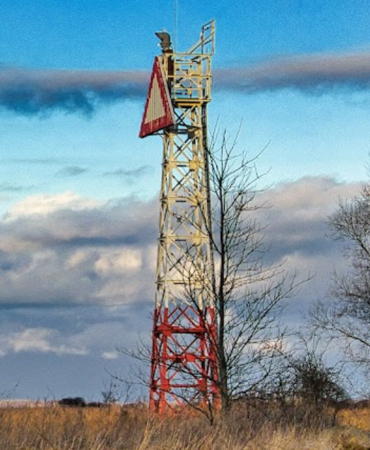
1938. Active; focal plane 12 m (39 ft); white light occulting once every 6 s. 11 m (36 ft) square skeletal tower, painted with red and white horizontal bands. The tower carries a triangular slatted daymark painted white with a red edge. A 2021 photo is at right, Trabas has a photo, and Google has a satellite view. This range is the reverse of the Bock Range; it guides vessels entering the Strelasund from the northwest. Located beside a farm road about 4 km (2.5 mi) northeast of Altefähr. Site open, tower closed. DE 216720; Admiralty C2585; NGA 5892.
* Bessiner Haken Oberfeuer
1938. Active; focal plane 30 m (98 ft); white light occulting once every 6 s. 18 m (59 ft) square skeletal tower, painted with red and white horizontal bands. The tower carries a large diamond-shaped slatted daymark painted white with a red edge. Trabas has a photo by Klaus Potschien and Google has a satellite view. This range is the reverse of the Bock Range; it guides vessels entering the Strelasund from the northwest. Located beside a farm road about 4 km (2.5 mi) northeast of Altefähr. Site open, tower closed. DE 216721; Admiralty C2585.1; NGA 5896.
#Stolper Haken Oberfeuer
1980. Inactive since 2013 and since demolished. This was a 24 m (79 ft) square skeletal tower, painted white. The tower also carried a triangular daymark, point down, painted white with a black border. Trabas has a photo but the tower is no longer seen in Google's satellite view. This range guided vessels northbound in the sound between Hiddensee and Rügen. The front light was on a similar tower 11 m (36 ft) in height. Located on a low point near the westernmost tip of Rügen. Site status unknown. ex-Admiralty C2589.31.
* Poggenhof Oberfeuer
1980. Active; focal plane 20 m (66 ft); white light occulting twice every 10 s. 17 m (56 ft) square skeletal tower, painted white. The tower also carries a triangular daymark, point down, painted white with a black border. Trabas has a photo and Google has a satellite view. This range guides vessels southbound in the sound between Hiddensee and Bug. The front light is on a shorter skeletal tower. Located next to a road on a low point near the village of Poggenhof. Site open, tower closed. DE 217501; Admiralty C2589.41.
Rassow Oberfeuer (2)
2019 (station established 1991). Inactive since 2023. 23 m (69 ft) square skeletal tower, painted white and carrying a triangular daymark pointed down. Google has a satellite view. The light was extinguished by storm damage in August 2023 ;it's not clear if it will be repaired. Meanwhile the tower serves as a daybeacon. Located in a farm field about 3 km (2 mi) east of the Poggenhof Oberfeuer. Site and tower closed. DE 217701; ex-Admiralty C2589.71.

Bessiner Haken Unterfeuer, Saßnitz, March 2021
Google Maps photo
by Rüganer Egon

Rügen: Northeast Coast (Baltic Sea) Lighthouses
**** Arkona (1) (Schinkelturm)
1828 (Friedrich Karl Schinkel). Inactive since 1905. 21 m (69 ft) square 3-stage brick tower with lantern and gallery, incorporating keeper's quarters. Tower is unpainted red brick; lantern has a black roof. Jarosław Mrzygłód's 2022 photo is at the top of this page, Hartmann has a page for the lighthouses, Klaus Helbig has a 2023 closeup, Anett Jauernig has a closeup photo, Wikimedia has photos, and Huelse has a historic postcard view showing both lighthouses. Kap Arkona, near the northern tip of Rügen, is the most prominent and dangerous cape on Germany's Baltic coast, so it is not surprising that the Kingdom of Prussia built this light station as early as 1828. The original tower was restored after reunification and opened to the public in 1993. Since 1996 it has housed a maritime and historical museum, which has since expanded to include a nearby keeper's house. The lighthouse also includes a registrar's office and is available for weddings. Its nickname Schinkelturm honors its designer, a Berlin architect. Located on the cape, near Putgarten on the Wittow peninsula. Site open, museum and tower open daily year round (hours vary). Site manager: Schinkelturm am Kap Arkona . ARLHS FED-065.
**** Arkona (2)
1905 (station established 1828). Active; focal plane 75 m; three white flashes, separated by 4 s, every 17 s. 35 m (115 ft) round brick tower with lantern and double gallery, rising from an octagonal granite base. Tower unpainted; lantern, watch room, and galleries painted red. Jarosław Mrzygłód's 2022 photo is at the top of this pageHartmann has a page for the lighthouses, Trabas has a good photo by Stephan Hix, Werning has a photo, Wikimedia has photos, Stefan Kassner has a street view, and Google has a satellite view. This wonderful German Imperial tower stands behind the original lighthouse and has been open to the public since 1996. Site open, tower open daily April through October. Operator: WSA Ostsee. ARLHS FED-010; DE 218800; Admiralty C2592; NGA 5900.
Kollicker Ort
1905 (Julius Pintsch). Active; focal plane 30 m (98 ft); white light, 1.5 s on, 4.5 s off; a narrow red sector is shone to the south over rocks close to shore. 7 m (23 ft) round cylindrical cast iron tower with lantern and half-gallery, painted white with red trim; lantern roof is black. 5th order Fresnel lens in use. Trabas has a great closeup photo by Klaus Potschien, Hartmann's page has a similar photo, and Klaus Rommel has a view from the sea, but the lighthouse hides in the trees in Google's satellite view of the cape. A twin of the Ranzow lighthouse (now at Lauterback, see below). Located on a ledge on the lower part of a 100 m (33 ft) forested cliff at the eastern tip of the Jasmund peninsula on the northeast side of Rügen about 6.5 km (4 mi) east of Hagen. Accessible by hiking trails in the Jasmund National Park. Site open, tower closed. Operator: WSA Ostsee. Site manager: Nationalpark Jasmund. . ARLHS FED-129; DE 218940; Admiralty C2596; NGA 5912.
* Saßnitz Ostmole
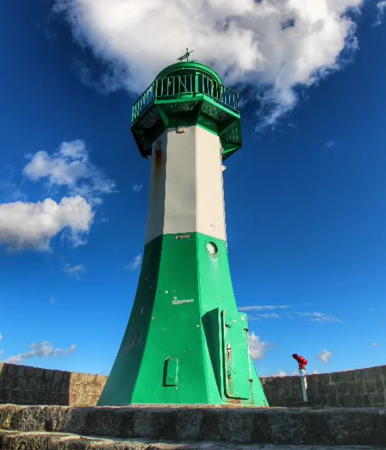
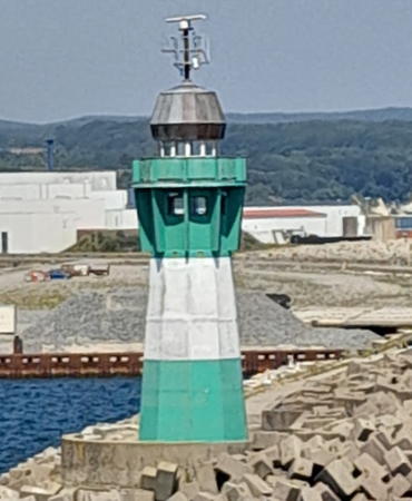
1937 (station established 1904). Active; focal plane 15 m (49 ft); white, red, or green light, depending on direction, occulting once every 6 s. 12 m (40 ft) tapered octagonal cast iron tower with lantern and gallery, painted green with one white horizontal band. 6th order Fresnel lens in use. Kai Schroeder's 2022 photo is at right, Hartmann has a page with a photo, Trabas has a fine closeup by Klaus Kern, Werning also has a photo, Helmut Hausfeld has a 2021 sunrise photo, Alexander Barnickel has a street view, and Google has a satellite view and a closeup street view. Michel Forand has a postcard view of the original lighthouse. Saßnitz has been replaced by Mukran as the principal ferry terminal for Rügen; the port is now used by fishermen and recreational boaters. This lighthouse stands at the end of the 1500 m (0.9 mi) east mole at the harbor entrance; accessible in good weather by walking the mole. Site open, tower closed. Operator:WSA Ostsee. . ARLHS FED-207; DE 219100; Admiralty C2602; NGA 5916.
* Saßnitz Westmole (Unterfeuer) (2)
1977 (station established 1911). Active; focal plane 10 m (33 ft); continuous red light; the tower also carries the front light of the Saßnitz Entrance Range, a red light occulting twice every 10 s, at a focal plane of 11 m (36 ft). 7 m (23 ft) tower in an unusual design: a large drum-style, 12-sided lantern supported by four L-shaped steel legs. Entire structure painted red. Trabas has a good photo by Hartmann, Werning has another good photo, Hartmann has a page for the range, a closeup is available, and Google has a street view and a satellite view. The original light was on a wood skeletal tower. Located at the end of the short west mole at the harbor entrance; accessible by walking the mole. Site open, tower closed. Operator: WSA Ostsee. ARLHS FED-208; DE 219910; Admiralty C2604; NGA 5920.

Saßnitz Ostmole Light, Saßnitz, July 2022
Instagram photo
by Kai Schroeder
Saßnitz Oberfeuer
1977. Active; focal plane 14 m (46 ft); red light occulting twice every 10 s (synchronized with the front light). Approx. 13 m (43 ft) square skeletal tower, painted white and carrying a triangular daymark painted white with a red border. Trabas has a photo by Hartmann and Google has a satellite view and a distant street view from the main breakwater. Located near the waterfront of Saßnitz harbor. Site status unknown. DE 219151; Admiralty C2604.1; NGA 5928.
Mukran Nordmole
1995. Active (privately maintained by the harbor operator); focal plane 16 m (52 ft); white or red light, depending on direction, 2 s on, 2 s off. 14 m (46 ft) octagonal tower with lantern and gallery, painted green with one white horizontal band. A 2022 photo by Jeannette Barz is at right, Hartmann has a page for the light, Trabas has a photo by Klaus Kern, Jaroslav Csampai has a closeup drone view, and Google has a satellite view. Located at the end of the north mole at Mukran, the new harbor of Saßnitz, about 5 km (3 mi) southwest of the old harbor. Site and tower closed; the mole is not open for walking. Good views from shore and better views from ferries departing the harbor for the Danish island of Bornholm, for Klaipeda, Lithuania, and for other destinations. Operator: Fährhafen Saßnitz GmbH. ARLHS FED-272; DE 219290; Admiralty C2614; NGA 5938.7.
* Prora
1986. Inactive since 1999. Approx. 23 m (75 ft) slender triangular concrete tower with a 2-story triangular lantern structure with double gallery. The lantern carries an array of antennas. The tower is unpainted concrete. Hartmann has a page for the lighthouse, Werning has a good photo, and Google has a satellite view. This modern structure was probably built more as a communications tower than as a lighthouse, although it carried a navigational light for 13 years. The light was a directional light for ships bound for Saßnitz. Located beside the coastal road in a pine forest about 20 km (13 mi) south of Saßnitz. Site open, tower closed. Owner/operator: unknown. ARLHS FED-190; ex-Admiralty C2612.
* Sellin
2008. Active; focal plane about 14 m (46 ft); yellow flash every 4 s. 14 m (46 ft) post carrying a large round diving bell (Tauchgondol) that can be lowered on the post. Trabas has Thomas Quatsling's photo, Oleksandr Cheban has a pier view, and Google has a satellite view. The diving bell is a tourist attraction, one of several such attractions Germany's Baltic coast. Located at the end of the pier at Sellin, a resort town on the southeastern peninsula of Rügen. Site and diving bell open. DE 219350; Admiralty C2618; NGA 5942.

Mukran Nordmole Light, Saßnitz, June 2022
Google Maps photo by Jeannette Barz

Rügen: Southeast Coast (Greifswald Bay) Lighthouse
Greifswald Bay is a shallow, roughly circular basin, about 25 km (15 mi) in diameter, between the islands of Rügen to the northwest and Usedom to the southeast.
* Lauterbach (ex-Ranzow)
1905 (Julius Pintsch). Relocated and reactivated (inactive 1999-2021); focal plane 8 m (26 ft); white, red or green light, depending on direction, occulting twoce every 10 s. 6 m (20 ft) round cylindrical cast iron tower with lantern and half-gallery, painted white. The Ranzow lighthouse was originally located on a headland of the Jasmund peninsula about 2 km (3 mi) east of Lohme. Werning's photo shows the lighthouse at its original location and Leuchtturm-Atlas has a page for it there. It was deactivated in 1999 and in 2002 it was relocated to Kap Arkona for display as part of the Schinkelturm museum. Hartmann also has a page for the lighthouse as the Ranzow light, Bernd Claußen has a good photo, and Google has a 2016 street view af the lighthouse at Kap Arkona. In June 2021 the lighthouse was relocated to serve as the leading light for vessels entering Lauterbach, a town on the southeastern coast of Rügen. Hartmann's photo of the lighthouse at Lauterbach is at right, Saskia Kobe has a 2023 photo, Trabas has Köhler's photo, and Bing has a satellite view. Located on the waterfront at Lauterbach. Site open, tower closed. ARLHS FED-193; DE 221020; Admiralty C2652.6 (ex-C2594 as Ranzow).

Rügen: South Coast (Strelasund) Lighthouses
The Strelasund is narrow strait separating Rügen from the German mainland. Lights in this group guide ships in the eastern approach to Stralsund, a city of about 60,000 residents on the southeast side of the Strelasund.

Grabow Oberfeuer
1937. Active; focal plane 19 m (62 ft); red light occulting twice every 10 s. 17 m (56 ft) square skeletal tower, painted with red and white horizontal bands. The tower also carries a large rectangular daymark painted white with a black border. Trabas has a photo by Eckhard Meyer and Google has a satellite view. This range guides vessels eastbound as they depart the Strelasund. Located in a forest near the southern tip of Rügen. Site status unknown. DE 221601; Admiralty C2628.1; NGA 6032.
GrabowUnterfeuer
1937. Active; focal plane 12 m (39 ft); red light occulting twice every 10 s. 11 m (36 ft) square skeletal tower, painted with red and white horizontal bands. The tower also carries a large rectangular daymark painted white with a black border. Trabas has a photo by Eckhard Meyer, a 2009 photo is available, and Google has a satellite view. Located on the north side of the Strelasund 450 m (0.28 mi) west of the Oberfeuer. Site appeasr open, tower closed. DE 221600; Admiralty C2628; NGA 6028.

Lauterbach Light, Lauterbach
photo copyright Erich Hartmann; used by permission
* Maltzien Unterfeuer
1937. Active; focal plane 12 m (40 ft); white light occulting once every 6 s. 12 m (39 ft) round concrete tower, painted white with a black vertical stripe facing the range line and mounted on a stone base. No lantern. Werning has a good page for the lighthouse, Hartmann has a page for the range, Trabas has a closeup photo by Eckhard Meyer, and Google has a satellite view. This light is the front light of the entrance range for the Strelasund, the eastern approach to the port of Stralsund. The range replaced the lightship Palmerort. The rear light is on a skeletal tower built in 1949. The lighthouse stands on the beach and is surrounded by water at high tide. Located on a point of land about 1 km (0.6 mi) southeast of the Glewitz ferry terminal on the southeastern shore of Rügen. Site open, tower closed. Operator: WSA Ostsee. ARLHS FED-150; DE 221500; Admiralty C2626; NGA 6020.
Maltzien Oberfeuer
1949. Active; focal plane 29 m (95 ft); white light occulting once every 6 s. 18 m (59 ft) square skeletal tower with gallery and a diamond-shaped daymark. Hartmann has a page for the range, Trabas has a photo by Eckhard Meyer and Google has a satellite view. Located in a farm field 675 m (0.42 mi) west northwest of the front light. Site and tower closed. DE 221501; Admiralty C2626.1; NGA 6024.
* Drigge Unterfeuer
1937. Active; focal plane 15 m (49 ft); green light occulting twice every 10 s. 14 m (46 ft) square skeletal tower, painted white with a red horizontal band. The tower also carries a triangular daymark, point up, painted white with a red border. Trabas has a photo by Klaus Potschien and Google has a street view and a satellite view. This range guides vessels westbound toward Stralsund as they approach the Drigger Ort (Drigge peninsula). Located on the waterfront of Drigge, a village on the low peninsula projecting into the Strelasund. Site open, tower closed. DE 221880; Admiralty C2638; NGA 6064.
* Drigge Oberfeuer
1937. Active; focal plane 24 m (79 ft); green light occulting twice every 10 s (synchronized with the front light). 23 m (75 ft) square skeletal tower, painted with red and white horizontal bands. The tower also carries a diamond-shaped daymark, painted white with a red border. Trabas has a photo by Klaus Potschien and Google has a satellite view. Located 535 m (1/3 mi) northwest of the front light. Site open, tower closed. DE 221881; Admiralty C2638.1; NGA 6068.

Stralsund Area Lighthouses
* Stralsund Hafeneinfahrt (Harbor Entrance)
1988. Active; focal plane 15 m (49 ft); white, red or green light depending on direction, occulting once every 6 s. 13 m (44 ft) square skeletal tower, painted with red and white horizontal bands. A drone view is at right, Trabas has a photo, a drone view is available, Radek Nykiel has a street view, and Google has an indistinct satellite view. Located on the main quay in downtown Stralsund, near the tall ship Gorch Fock I; the light is at the right of Wikimedia's 2013 photo of the ship, seen at right. Site open, tower closed. DE 217010; Admiralty C2585.45.
* Stralsund Oberfeuer
1938. Active; focal plane 24 m (79 ft); white, red or green light depending on direction, 2 s on, 2 s off. 21 m (69 ft) square skeletal tower, painted white. Trabas has a photo and Google has a satellite view. The original rear range light was replaced in 2014 with the three-color directional light; it guides vessels southbound to the Stralsund waterfront. The original front light, on a mast in a marina at the west end of the island of Dänholm, was deactivated in 2015; Hartmann's page has photos of the original light and its replacement installed in 2019. Located at the foot of the Ziegelstraße on the Stralsund waterfront, between the old and new Rügen Bridges. Site open, tower closed. DE 216901; Admiralty C2585.6.
* Andershof Unterfeuer
1937. Active; focal plane 22 m (72 ft); red, white,or green light, depending on direction, occulting once every 6 s. 14 m (46 ft) square skeletal tower, painted white with a red horizontal band. The tower also carries a triangular daymark, point up, painted white with a red border. Trabas has a photo and Google has a satellite view. This tower carries the front light of a range guiding vessels westbound (approaching Stralsund) as well as a leading (sector) light that guides vessels eastbound (departing Stralsund). Located on the waterfront just southeast of Andershof, a village on the Strelasund south of Stralsund. Site open, tower closed. DE 222080; Admiralty C2644; NGA 6084.
* Andershof Oberfeuer
1937. Active; focal plane 39 m (128 ft); green light occulting once every 6 s (synchronized with the front light). 15 m (49 ft) square skeletal tower, painted with red and white horizontal bands. The tower also carries a huge pentagonal daymark, painted white with a red border. Trabas has a photo and Google has a satellite view and a distant street view. This is the rear light for the westbound range (see previous entry). Located 440 m (1/4 mi) south southwest of the front light. Site open, tower closed. DE 222081; Admiralty C2644.1; NGA 6096.

Harbor Entrance Light, Stralsund, June 2018
Google Maps drone view by Stralsund Passion
Falkenhagen Oberfeuer
1972. Active; focal plane 40 m (131 ft); white light, 5 s on, 1 s off. 29 m (95 ft) square skeletal tower painted white and carrying a diamond-shaped daymark painted white with a red border. Trabas has a photo and Google has a satellite view. This is the entrance range guiding vessels across the Greifswalder Bodden (Greifswald Bay), the roughly circular bay between Rügen and Peenemünde. Located at the edge of a farm field southeast of Reinberg. Site and tower closed. DE 221401; Admiralty C2652.81; NGA 6016.
Falkenhagen Unterfeuer
1972. Active; focal plane 14 m (46 ft); white light, 5 s on, 1 s off. 12 m (39 ft) square skeletal tower painted white; the front face carries a slatted daymark painted white with a red border. Trabas has a photo and Google has a satellite view. Located in a farm field at the west shore of the bay, 2.1 km (1.3 mi) east of the rear light. Site and tower closed. DE 221400; Admiralty C2652.8; NGA 6012.

Information available on lost lighthouses:

Notable faux lighthouses:

Adjoining pages: North: Denmark: Sjælland Region | East: Vorpommern-Greifswald | West: Mecklenburg

Return to the Lighthouse Directory index | Ratings key

Posted April 9, 2005. Checked and revised May 25, 2024. Lighthouses: 37. Site copyright 2024 Russ Rowlett and the University of North Carolina at Chapel Hill.