Lighthouses of Central Algeria

The People's Democratic Republic of Algeria (al-dzāyīr in Algerian Arabic) is a North African country with a 1280 km (800 mi) long coastline on the southwestern shore of the Mediterranean opposite France and Spain. French troops captured the city of Algiers in 1830 and subdued the country gradually over several decades of fighting. The country remained a French colony through World War II. A bitter struggle in the 1950s led to independence in 1962.

Algeria is divided into 58 provinces. This page describes lighthouses in five provinces of the central Algerian coast from Algiers eastward through Béjaïa. There are separate pages for lighthouses of Western Algeria and Eastern Algeria.

Arabic is an official language of Algeria and most residents speak a variety of Arabic called Darja. French is widely used in government and media and more than half of the population also speaks French. The Arabic word for a lighthouse is mnarh or manara (منارة). Ra's is a cape, jaza'ir or jazirat is an island, shi'b is a reef, shira' is a bay, and marfa is a harbor. In French phare is the word for a lighthouse, île is an island, cap is a cape, pointe is a promontory or point of land, roche is a rock, récife is a reef, baie is a bay, estuaire is an estuary or inlet, détroit is a strait, rivière is a river, and havre is a harbor.

Aids to navigation in Algeria are operated by the Office National de Signalisation Maritime (ONSM). Most of the historic French lighthouses are being maintained and most still have resident keepers.

ARLHS numbers are from the ARLHS World List of Lights. Admiralty numbers are from volume E of the Admiralty List of Lights & Fog Signals. U.S. NGA List numbers are from Publication 113.

General Sources
Phares et Feux de Jalonnement
Lighthouse information posted by ONSM; photos of the major lighthouse are included.
Online List of Lights -Algeria
Photos by various photographers posted by Alexander Trabas.
World of Lighthouses - Algeria
Photos by various photographers posted by Lightphotos.net.
Phares d'Afrique
Photos of African lighthouses posted by Alain Guyomard and Robert Carceller on the Phares du Monde web site.
Lighthouses in Algeria
Photos available from Wikimedia.
Afrikanische Leuchttürme auf historischen Postkarten
Historic postcard images posted by Klaus Huelse.
GPSNauticalCharts
Navigational chart information for Algeria.
Navionics Charts
Navigational chart for Algeria.


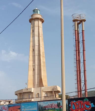
2010 Cap Bengut Light, Dellys
ONSM photo

Alger (Algiers) Province Lighthouses
The capital and largest city of Algeria, Algiers has a metropolitan population of about 4 million.
* Sidi Fredj (Sidi Ferruch)
Date unknown (probably around 1970). Active; focal plane 42 m (138 ft); three white flashes every 12 s. 24 m (79 ft) white building, the light being displayed from the top. Ismail Zakraoui has a photo, the building is at the right in Mohamed Kaouche's photo, and Google has a satellite view. The nature of the building is not known. Sidi Fredj (formerly Sidi Ferruch) is one of the few tourist developments in Algeria and the only harbor in the country catering specifically to yachts. The area, about 20 km (13 mi) west of Algiers, has historic significance as the site of the first French troop landings in 1830. Located at the northeastern corner of the Sidi Fredj peninsula, adjacent to the marina. Site open, tower status unknown. ARLHS ALG-046; Admiralty E6624; NGA 22432.
* Sidi Fredj Jetée Principale (2)
Date unknown. Active; focal plane 14 m (46 ft); white or green light, depending on direction, 2 s on, 2 s off. 10 m (33 ft) square cylindrical white concrete tower standing on a semicircular 1-story pierhead structure. A photo is available, Mohamed Kaouche has a 2023 view, and Google has a satellite view. An observation platform surrounds the light. Trabas has a photo of the original post light. Located at the end of the main breakwater of Sidi Fredj. Accessible by walking the pier. Site open, tower closed. Admiralty E6624.6; NGA 22434.
* Port D'El Djamila (Port Madrague) Secondary Jetty
Date unknown. Active; focal plane about 12 m (39 ft); green light, pattern unknown. Approx. 8 m (26 ft) tower attached to a 1-story equipment shelter. Tower painted white with a green top. This light is at the left in Ahmed Benaissa's photo of the harbor and Google has a satellite view. Located on the inner breakwater at Port Madrague, the harbor of the El Djamila neighborhood about 8 km (5 mi) northeast of Sidi Fredj. Accessible by walking the pier. Site open, tower closed. Admiralty E6622.5.
* Port D'El Djamila (Port Madrague) Main Jetty
Date unknown. Active; focal plane about 12 m (39 ft); red light, pattern unknown. Approx. 8 m (26 ft) tower attached to a 1-story equipment shelter. Tower painted white with a red top. A 2024 view from the sea is available, the light is in the center in Ahmed Benaissa's photo of the harbor and Google has a satellite view. Located on the main breakwater at Port Madrague. Accessible by walking the pier. Site open, tower closed. Admiralty E6622.
* Cap Caxine
1868. Active; focal plane 64 m (210 ft); white flash every 5 s. 33 m (108 ft) square masonry tower with lantern and gallery, rising from a 2-story masonry keeper's house. Lighthouse painted white, lantern blue. A 2024 photo is at right, Allel Ghebache has a closeup photo, Derbal Abdeladhim has a photo, Neila Matoub has a 2021 photo, Wikimedia has photos, and Google has a satellite view. This lighthouse is the landfall light for Algiers for eastbound ships. Located on a headland just of the N11 highway at Boukikax, about 15 km (9 mi) west of Algiers and 5 km (3 mi) northeast of Aïn Benian. Site open, tower closed. ARLHS ALG-008; Admiralty E6621; NGA 22424.

Cap Caxine Light, Algiers, April 2024
Google Maps photo by marabout ski
* Alger (Amirauté, Le Peñon)
1834 (station established before 1700). Inactive since the 1920s or 1930s. 16 m (52 ft) 12-sided cylindrical tower with lantern and gallery rising from a 12-sided building. Lighthouse painted white, lantern black. A 2023 photo is at right, Mohamed Bisker has a 2009 photo, Lightphotos.net has a photo, Lucien Luy has a 2022 view, and Google has a satellite view. The Peñon is a 16th century fortress at the center of the Amirauté (Admiralty), a complex of historic buildings on what was originally several small islands just off the coast. (In Arabic this bastion was called simply El Djazaïr (the islands); "Alger" and "Algeria" are corruptions of this Arabic name.) Located near the foot of the Jetée du Nord, on a small island now connected to the mainland by a causeway. Site open, tower closed. ARLHS ALG-024 (=048).
Alger Jetée Kheireddine Head
Date unknown. Active; focal plane 23 m (75 ft); two white flashes every 3 s. 17 m (56 ft) white concrete post with gallery. Mezghrani Mohamed has a 2021 photo, this light appears in the distance in Trabas's photo and Google has a satellite view. Located at the end of the 1.5 km (1 mi) Jetée du Nord, the breakwater protecting the harbor of Algiers. Site and tower closed. Admiralty E6602; NGA 22380.
Alger Jetée Kheireddine Spur (Passe Nord Feu Vert)
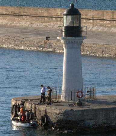
1868. Active; focal plane 10 m (33 ft); green flash every 4 s. 8 m (26 ft) round masonry tower with lantern and gallery. Lighthouse painted white, lantern green. A photo by John Perivolaris is below right, Trabas has a distant photo and Google has a satellite view. The focal plane and tower heights listed appear to be too low, based on the photo. Located on a spur of the Jetée du Nord, marking the north side of the Passe Nord entrance. Accessible only by boat. Site open, tower closed. Admiralty E6604; NGA 22384.
Alger Passe Nord Feu Rouge
Date unknown (station established 1868). Active; focal plane 10 m (33 ft); red flash every 4 s. 7 m (23 ft) round masonry tower with lantern and gallery. Lighthouse painted white, lantern red. Yacine Timez has a 2017 photo, Mezghrani Mohamed has a 2021 photo, Trabas has a distant view, and Google has a satellite view. The focal plane and tower heights listed appear to be too low, based on the photos. Located at the north end of the of the detached Jetée de l'Est breakwater, marking the south side of the Passe Nord entrance. Accessible only by boat. Site open, tower closed. ARLHS ALG-032; Admiralty E6606; NGA 22388.

Phare de l'Amirauté, Alger, September 2023
Google Maps photo by Bali Photographie
Alger Bassin de l'Agha Nord
Date unknown. Active; continuous green light. 7 m (23 ft) post attached to a small equipment shelter. Lighthouse painted white, lantern green. This light is in the center of Omar Branine's view of the harbor and on the right in Mezghrani Mohamed's photo, and Google has a satellite view. Located on the northernmost spur of the detached main breakwater of Algiers, marking the east side of the northern entrance to the inner harbor. Accessible only by boat. Site status unknown. Admiralty E6617; NGA 22420.
Alger Môle du Amiral Mouchez
Date unknown. Active; continuous red light. 7 m (23 ft) post attached to a small equipment shelter. Lighthouse painted white, lantern red. No photo available but Google has a satellite view. Located on the northeast corner of the mole, marking the west side of the northern entrance to the inner harbor. Site status unknown. Admiralty E6616; NGA 22416.
Alger Bassin de l'Agha Sud (Passe Mustapha Feu Vert)
Date unknown. Active; continuous green light. 7 m (23 ft) round masonry tower with lantern and gallery. Lighthouse painted white, lantern green. This light is on the left in a distant view and Google has a satellite view. Located on the central spur of the detached main breakwater of Algiers, marking the north side of the southern entrance to the inner harbor. Accessible only by boat. Site status unknown. Admiralty E6613; NGA 22412.
Alger Grand Môle (Passe Mustapha Feu Rouge)
Date unknown. Active; continuous red light. 7 m (23 ft) round masonry tower with lantern and gallery. Lighthouse painted white, lantern red. This light is on the right in a distant view and Google has a satellite view. Located on a short breakwater projecting from the Grand Môle of Algiers, marking the south side of the southern entrance to the inner harbor. Site status unknown. Admiralty E6612; NGA 22408.
Alger Passe Sud Feu Vert (Jetée Mustapha Spur)
Date unknown. Active; focal plane 12 m (39 ft); green light, 2 s on, 2 s off. 7 m (23 ft) round masonry tower with lantern and gallery. Lighthouse painted white, lantern green. Trabas has a distant photo and Google has a satellite view. Located on the easternmost spur of the detached main breakwater of Algiers, marking the southern entrance to the harbor. Accessible only by boat. Site status unknown. Admiralty E6611; NGA 22400.
Feu de la Jetée Mustapha
Feu Vert de la Passe Nord, Alger, June 2010
Flickr Creative Commons photo by John Perivolaris
Alger Passe Sud Feu Rouge (Brise-Lames Est)
Date unknown. Active; focal plane 12 m (39 ft); red light, 3 s on, 1 s off. 7 m (23 ft) round masonry tower with lantern and gallery. Lighthouse painted white, lantern red. No photo available but Google has a satellite view. Located on the easternmost breakwater of Algiers, marking the southern entrance to the harbor. Accessible only by boat. Site status unknown. Admiralty E6610; NGA 22404.
* Cap Matifou (2?)
Date unknown (station established 1868). Active; focal plane 74 m (243 ft); three white flashes every 15 s. Approx. 11 m (36 ft) round stone tower. Amine Lido has the 2021 photo seen at right and Google has a satellite view. NGA describes an 11 m (36 ft) white square tower; this is probably the original tower, with lantern gallery attached to the front of a 1-story keeper's house. Huelse has a historic postcard view showing the original appearance of the lighthouse and Forand has a similar postcard view. ONSM has a page for the lighthouse but the photo on that page is of the Tipaza lighthouse. Located on a headland at the eastern entrance to the Bay of Algiers, about 3 km (2 mi) northwest of Aïn Taya. Site status unknown but probably open, tower closed. ARLHS ALG-014; Admiralty E6594; NGA 22368

Boumerdès Province (Dellys Area) Lighthouses
Zemmouri El-Bahri (Courbet-Marine) Secondary Jetty
Date unknown. Active; focal plane about 22 m (72 ft); green light, pattern unknown. Approx. 17 m (56 ft) square cylindrical skeletal tower, white with a green top. Brahim Nedjadi has a 2022 view across the harbor, Hamid Chabane has a distant view and Google has a satellite view. Located on the west breakwater at Zemmouri El-Bahri, a small port about 60 km (36 mi) east of Algiers. Site status unknown. Admiralty E6593.5.

Cap Matifou Light, Algiers, April 2021
Google Maps photo by Amine Lido
Zemmouri El-Bahri (Courbet-Marine) Main Pier
Date unknown. Active; focal plane about 22 m (72 ft); red light, pattern unknown. Approx. 17 m (56 ft) square cylindrical skeletal tower, white with a red top. Hamid Chabane has a distant view (this light is in the distance on the right) and Google has a satellite view. Located on the north breakwater at Zemmouri El-Bahri. Site status unknown. Admiralty E6593.8.
Djinet (Djinned, Djenet) Secondary Jetty
Date unknown. Active; focal plane about 14 m (46 ft); three green flashes every 12 s. Approx. 10 m (30 ft) square cylindrical tower with an orange horizontal band at the top. Ilyas Aouadi has a street view across the harbor and Google has a satellite view. Located on the east (inner) jetty at Djinet, a small port halfway between Zemmouri and Dellys. Site status unknown. Admiralty E6593.2; NGA 22362.2.
Djinet (Djinned, Cape Djenet) Main Jetty (2)
2020. Active; focal plane about 14 m (46 ft); three red flashes every 12 s. Approx. 10 m (33 ft) tower, painted with red and white horizontal bands, rising from a square white equipment building. Ilyas Aouadi has a distant street view and Google has an indistinct satellite view. The previous light was on a triangular skeletal mast. Located on the west (outer) jetty at Djinet. Site status unknown. Active light: Admiralty E6593; NGA 22362.
* Cap Bengut (1)
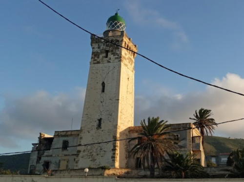
1881. Inactive since 2003. 29 m (95 ft) square masonry tower with lantern and gallery, rising from a 2-story keeper's house. Lighthouse painted white, lantern dome green. This elegant and historic lighthouse was damaged seriously by the earthquake of 21 May 2003, which caused great damage throughout the Dellys area. Damage is visible in a 2008 photo by Mazouz Abdelaziz. A 2020 photo by Karim Fares is at right, Yahia Alzaatreh has a 2019 photo, Lightphotos.net has a historic postcard view and Google has a satellite view. A new lighthouse was completed in 2010 (description below and photo above). In 2009 work began to stabilize the old one, which is to be preserved as a historic monument. Hacene Hacntizi's 2017 photo of all three Bengut lighthouses shows how this tower has been patched up. Located in a residential neighborhood on a headland west of Dellys, about 4 km (2.5 mi) west of the Pointe de Dellys lighthouse. Site open, tower closed. ARLHS ALG-005.
Cap Bengut (2)
2004. Inactive since 2017. Approx. 15 m (49 ft) triangular cylindrical skeletal tower. Lighthouse painted red with a white band at the top. Hacene Hacntizi has a 2017 photo of all three Bengut lighthouses. This temporary tower replaced the light in the historic lighthouse after the 2003 earthquake. It served for seven years and was still in place as seen in Azzaz Merouane's November 2020 drone view. Located near the historic lighthouse. Site open, tower closed.

Old Cap Bengut Light, Dellys, October 2020
Google Maps photo by Karim Fares
* Cap Bengut (3)
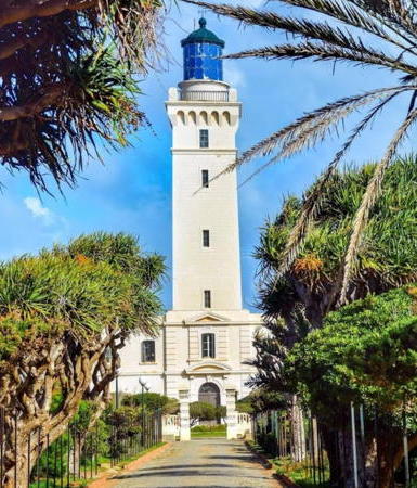
2010. Active; focal plane 63 m (207 ft); four white flashes every 15 s. 29 m (95 ft) octagonal concrete tower with four robust buttresses, lantern and gallery, rising from a semicircular 1-story administration building. The tower is unpainted white concrete; lantern gray metallic. An ONSM photo is at the top of this page, Fouad Bouabdellah has a 2017 photo, Hacene Hacntizi has a 2017 photo of all three Bengut lighthouses, and Google has a satellite view. Located a few feet east of the historic lighthouse. Site open, tower closed. . DZ-2700; Admiralty E6592; NGA 22360.
#Pointe de Dellys (Dalïs) (1)
1884. Inactive since 2003. This was an 8 m (26 ft) round cylindrical tower with lantern and gallery, attached to a small keeper's house. Lighthouse is white; lantern roof red. This lighthouse was heavily damaged by the earthquake of 21 May 2003. A 2007 photo and a 2017 photo show the ruins of the old lighthouse behind the new one. Google has a satellite view. The lighthouse was often called the Petit (small) Phare de Dellys to distinguish it from the larger Cap Bengut lighthouse. Located at the end of a very sharp (spear-like) point of land projecting into the Mediterranean just north of the port of Dellys. Site and tower closed.
Pointe de Dellys (Dalïs) (2)
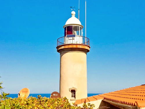
2007(?). Active; focal plane 41 m (135 ft); continuous red light. Approx. 15 m (49 ft) octagonal cylindrical concrete tower with lantern and gallery. Lighthouse painted tan with white trim; lantern painted red. A 2023 photo by Octado Marcos is at right, Yassine Marcimini has a 2021 photo, Hacene Hacntizi has a 2017 photo, Arif Yelles has a 2016 photo, and Google has a satellite view. Site open (but not easy to reach), tower closed. ARLHS ALG-020; Admiralty E6584; NGA 22348.

Pointe de Dellys Light, Dellys, May 2023
Google Maps photo by Octado Marcos

Tizi Ouzou Province (Tigzirt Area) Lighthouses
* Tigzirt South Breakwater
Date unknown. Active (?); focal plane about 10 m (33 ft); green light, pattern unknown. 7.5 m (25 ft) hexagonal cylindrical tower rising from a square 1-story equipment shelter. Lighthouse unpainted except for green bands at the top. Wikimedia has Fahim Moussaoui's photo of both breakwater lighthouses, Bourkache Noureddine has a 2022 photo, Lightphotos.net has a photo of the two breakwater lighthouses, Wikipedia also has a distant view, and Google has a street view and a satellite view. Located on the south breakwater of Tigzirt, a small port about 25 km (15 mi) east of Dellys. Accessible by walking the pier. Site open, tower closed. Not listed by the Admiralty.
* Tigzirt North Breakwater
Date unknown. Active (?); focal plane about 10 m (33 ft); red light, pattern unknown. 7.5 m (25 ft) hexagonal cylindrical tower rising from a square 1-story equipment shelter. Lighthouse unpainted except for red bands at the top. Wikimedia has Fahim Moussaoui's photo of both breakwater lighthouses, Bourkache Noureddine has a 2022 closeup photo, Lightphotos.net has a photo of the two breakwater lighthouses, Wikipedia also has a distant view, and Google has a street view and a satellite view. Located on the north breakwater of Tigzirt. Accessible by walking the pier. Site open, tower closed. Not listed by the Admiralty.
Cap Corbelin
1908. Active; focal plane 42 m (138 ft); three flashes in a 2+1 pattern, white or red depending on direction, every 15 s. 13 m (43 ft) round tower with lantern and gallery, painted white. Two keeper's houses. Trabas has a closeup photo, An ONSM photo is at right, Lightphotos.net has a sunset photo and a historic postcard view, and Google has a satellite view. Located beside the N24 coastal highway on a headland near Azeffoun. Site status unknown. ARLHS ALG-009; Admiralty E6580; NGA 22340.
 

Cap Corbelin Light, Azeffoun
ONSM photo
 

Béjaïa Province Lighthouses
The ancient city of Béjaïa was called Saidae in Roman times and Bougie under French rule. Today it is an important terminal for the shipment of oil from Sahara oil fields.
* Cap Sigli
1906. Active; focal plane 57 m (187 ft); white flash every 5 s. 25 m (82 ft) octagonal cylindrical tower with lantern and gallery, attached to a 1-story keeper's house. Lighthouse painted white, lantern and gallery black. A 2023 photo is at right, Trabas has a closeup photo, Hamadouche Azzedine has a closeup photo, a good 2008 photo is available, and Google has a satellite view. The lighthouse also carries an aviation beacon. Located on a headland about 50 km (30 mi) west northwest of Béjaïa. The site is easily accessible from the coast N24 highway. Site open, tower closed. . ARLHS ALG-016; Admiralty E6578; NGA 22336.
Cap Carbon
1851. Active; focal plane 220 m (722 ft); three white flashes every 20 s. 10 m (33 ft) round cylindrical tower with lantern and gallery, rising from a compact keeper's house complex. Lighthouse painted white. Harbor control station. This lighthouse is perched atop a giant rock, similar to the Rock of Gibraltar, where the Grande Kabylie range of the Atlas Mountains comes down to the sea. Wikimedia has Yves Jalabert's photo, a closeup is available, Lightphotos.net has a good photo, the lighthouse can be seen in Cyril Preiss's photo of the cape, a July 2005 view is also available, Krimo Bendaoud has a view from the sea, Huelse has a historic postcard view, and Google has a satellite view. The cape is included in the Gouraya National Park. Located a scant 3 km (1.75 mi) north of the port of Béjaïa (called Bougie in colonial times). Site and tower closed. ARLHS ALG-007; Admiralty E6572; NGA 22328.
Cap Carbon Lower (Feu Auxiliare)
1908. Active; focal plane 32 m (105 ft); flash every 1.5 s, white or red depending on direction. 8 m (26 ft) round cylindrical tower attached to a 1-story keeper's house. Lighthouse painted white. Sidahmed Kheloufi has a 2021 photo, another photo is available, and Google has a satellite view. This second Cap Carbon lighthouse was built because the primary light is sometimes obscured by low clouds. It is located at the foot of the cliff 150 m (490 ft) northeast of the primary light -- and 186 m (610 ft) straight down. Site and tower closed. ARLHS ALG-057; Admiralty E6573; NGA 22332.
Béjaïa (Jetée Est)
Date unknown (station established 1901). Active; focal plane 16 m (52 ft); white light occulting once every 4 s. 15 m (49 ft) tripod tower, painted white; lantern is black. Trabas has a distant view, Lakhdar Azeddine Bedjou has a distant street view, and Google has a satellite view. Located at the end of the east breakwater of Béjaïa. Site and tower closed. Admiralty E6566; NGA 22324.

Cap Sigli Light, Béjaïa, February 2023
Instagram photo by fouad_dz18
 

Adjoining pages: East: Eastern Algeria | West: Western Algeria

Return to the Lighthouse Directory index | Ratings key

Posted August 8, 2005. Checked and revised June 17, 2024. Lighthouses: 32. Site copyright 2024 Russ Rowlett and the University of North Carolina at Chapel Hill.