- Jijel (Djidjelli) Province Lighthouses
- Jijel is a provincial capital and fishing port also known for its nearby beaches. A new industrial port has been developed east of the city. The city's population is about 130,000.
Île Mansouria (Ziama Mansouriah)- Date unknown. Active; focal plane 21 m (69 ft); white flash every 2.5 s. 6 m (20 ft) post rising from a square 1-story equipment shelter. The post is white with a black top. Badrdine Nazym has a 2024 closeup photo, Lightphotos.net has a view of the light, and Google has an indistinct satellite view. Located atop a tombolo (an island tenuously connected to the mainland) that shelters the harbor of Ziama Mansouriah, a small part at the western edge of Jijel Province. Site status unknown. Admiralty E6562; NGA 22316.
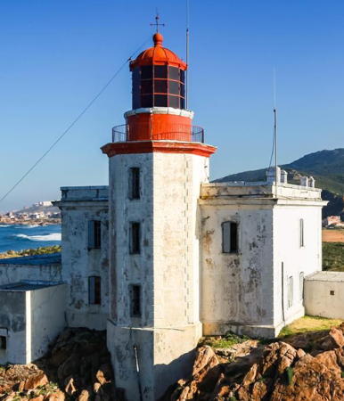
- * Ra's Afia (Grand Phare de Jijel)
- 1871. Active; focal plane 43 m (141 ft); red flash every 5 s. 14 m (46
ft) octagonal tower with lantern and gallery, attached to the front of a
2-story keeper's house. Lighthouse painted white; lantern is red. A 2020 photo is at the top of this page, Wikimedia has a 2013 photo, Naim Hallal has a 2011 photo, Fateh Achour has a 2020 closeup, a distant photo and a page of photos are
available, Rachid Merzougui has a 2008 photo,
Huelse has a historic postcard
view, and Google has a good satellite
view. This well-known and often-photographed lighthouse is at the
end of a sharp peninsula a short distance off the coastal N43 highway
about 8 km (5 mi) west of Jijel. Site open, tower closed.
 . ARLHS ALG-029;
Admiralty E6558; NGA 22308. . ARLHS ALG-029;
Admiralty E6558; NGA 22308.
- * Jijel
(Djidjelli) Jetée Nord (Petit Phare de Jijel)
- 1841. Active; focal plane 19 m (62 ft); white or red light, depending on
direction, occulting three times, in a 1+2 pattern, every 12 s. 12 m (39
ft) square masonry tower with lantern and gallery. Lighthouse painted white,
lantern black.
Lightphotos.net has a 2012 photo and a historic photo showing the former keeper's house, and Google has a satellite
view. Located at the elbow of the north jetty in Jijel, which is the
breakwater for the harbor. Site open, tower closed. ARLHS ALG-040; Admiralty
E6550; NGA 22292.
- Djen-Djen North Breakwater
- Date unknown. Active; focal plane 18 m (59 ft); white flash every 6 s. Approx. 15 m (49 ft) round white concrete tower. Trabas has Capt. Peter Mosselberger's photo, MarineTraffic.com has a distant view and Google has a satellite view. Located on the main breakwater of Port Djen-Djen, the new commercial port about 15 km (9 mi) east of Jijel. Site status unknown. Admiralty
E6548.
- Djen-Djen North Breakwater Spur
- Date unknown. Active; focal plane 16 m (52 ft); green flash every 4 s. Approx. 13 m (43 ft) round green concrete tower. Trabas has Capt. Peter Mosselberger's photo and Google has a satellite view. Located on a spur of the main breakwater of Port Djen-Djen. Site status unknown. Admiralty
E6548.1.
- Djen-Djen West Pier Leading
- Date unknown. Active; focal plane 21 m (62 ft); flash every 4 s, white, red or green depending on direction. Approx. 15 m (49 ft) round red concrete tower. Trabas has Capt. Peter Mosselberger's photo and Google has a satellite view. Located on the pier at the base of the north breakwater. Site status unknown. Admiralty
E6549.55.
- Djen-Djen East Breakwater
- Date unknown. Active; focal plane 16 m (52 ft); red flash every 4 s. Approx. 13 m (43 ft) round red concrete tower. Trabas has Capt. Peter Mosselberger's photo and Google has a satellite view. Located on the east breakwater of Port Djen-Djen opposite the north breakwater spur. Site status unknown. Admiralty
E6548.2.
- Djen-Djen Mixed Quay Leading
- Date unknown. Active; focal plane 21 m (62 ft); flash every 4 s, white, red or green depending on direction. Approx. 15 m (49 ft) round red concrete tower. Trabas has Capt. Peter Mosselberger's photo and Google has a satellite view. Located in the harbor area south of the base of the east breakwater. Site status unknown. Admiralty
E6548.49.
|
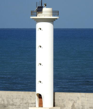 Djen-Djen North Breakwater Light, Jijel, October 2021
photo copyright Capt. Peter Mosselberger; used by permission |
Skikda Province Lighthouses
- Built on the site of an ancient Phoenician port, Skikda was founded by the French as Philippeville in 1838. The name was changed to Skikda in 1962. The city has a population of about 250,000.
Ra's el Maghreb (2)- 1906 (station established 1871). Inactive. Round masonry tower centered
on a keeper's house. The building is in ruins. A 2024 closeup and view from above are available and Google has a satellite
view. The lighthouse had a focal plane of 54 m (177 ft), substantially
higher than the present lighthouse. The abandoned buildings must be endangered.
- Ra's el Maghreb (3)
- Date unknown (station established 1871). Appears inactive but listed with focal plane 30 m (98 ft);
white flash every 4 s. 15 m (49 ft) round tower rising from an equipment building. The building seems to be abandoned. Entire structure is (or was) white. A 2024 photo is available and Google has an indistinct satellite
view. More information is needed on the history of this station. Located
on a headland about 10 km (6.5 mi) west of Ouled Attia. This area is quite remote. Site status unknown.
ARLHS ALG-045; Admiralty E6544; NGA 22288.
- Cap Bougaroun (2)
- 1911 (station established 1869). Active; focal plane 91 m (299 ft); two white flashes every 10 s.
10 m (33 ft) octagonal tower with lantern and gallery, attached to the front
of a 2-story keeper's house. Lighthouse painted white.
An 2023 closeup photo is at right, Dadarahim Ramy has the ONSM photo, Amam Yacine has a photo, Samir Boulaid has a 2018 closeup, and Google has a satellite
view. The lantern appears to have been transferred from the historic lighthouse (next entry). Located on a steep bluff at the northernmost point of the
province, about 15 km (9 mi) northwest of Collo. Site status unknown. Admiralty E6542; NGA 22284.
- Cap Bougaroun (1)
- 1869. Inactive since 1911.
Approx. 10 m (33 ft) octagonal tower attached to the front
of a 2-story keeper's house. Lantern removed. The lighthouse is unpainted.
Barkat Salim has a 2021 closeup photo, Faycal Sadoune has a 2019 closeup, and Google has a satellite
view. Above the lighthouse is a sémaphore (signal station) of roughly similar design but without a lantern. The lighthouse had a focal plane of 172 m (564 ft), making it too high in bad weather. The building apparently has been renovated as a school. Located about 800 m (1/2 mi) southeast of the modern lighthouse. Site open, tower closed. ARLHS
ALG-006.
|
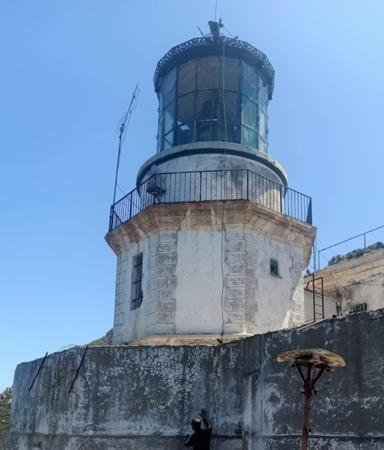 1911 Cap Bougaroun Light, Collo, September 2023
Google Maps photo by marabout ski |
- Cap
Collo (Pointe Djerda)
- 1863. Active; focal plane 26 m (85 ft); green flash every 5 s. 11 m (36
ft) octagonal tower with lantern and gallery attached to the front of a
2-story keeper's house. Lighthouse painted white; lantern painted green.
Salim Laib has a 2017 photo,
Aymen Louhab has a photo,
and Google has a satellite
view. Located on a sharp point at the end of the Djerda peninsula about
2.5 km (1.5 mi) northeast of Collo. Site status unknown. ARLHS ALG-044;
Admiralty E6540; NGA 22280.
- Île
Srigina (2)
- 1906 (station established 1847). Active; focal plane 54 m (177 ft); red
flash every 5 s. 12 m (39 ft) square cylindrical tower with lantern and
gallery, rising from a 2-story keeper's house. Tower painted white; lantern
dome is red. Farid Mada Tourid's 2020 photo is at right, Lightphotos.net has Ghalem Arsalan's closeup photo, Metatla Noureddine has a 2012 aerial view, Abdeslam Benlarbi has closeup photos (near the bottom of the page), and Google has a satellite
view. This lighthouse marks the western entrance to the Golfe de Stora.
Located atop a steep-sided island about 4 km (2.5 mi) north of Stora. Accessible
only by boat. Site and tower closed. ARLHS ALG-023; Admiralty E6534; NGA
22272.
- Île du Lion
- Date unknown. Active; focal plane about 27 m (89 ft); green flash every 5 s. 13 m (43 ft) square skeletal tower topped by an enclosed structure accessed by an external ladder. Skeletal tower painted white, top structure green. Fahed Chater has a distant view from the sea, Djamel Bou also has a distant view, and the slender tower is centered in Google's satellite view. Located atop a small island about 1.6 km (1 mi) south of Île Srigina. Accessible
only by boat. Site and tower closed. Admiralty E6533; NGA
22268.
|
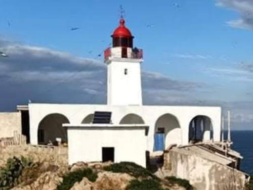 Île Srigina Light, Stora, December 2020
Google Maps photo by Farid Mada Tourid |
- * Îlot
des Singes (Stora)
- 1847. Active; focal plane 17 m (56 ft); continuous light, white or green
depending on direction. 9 m (30 ft) square stone tower with lantern and
gallery, mounted on the platform of a former medieval fort. A 2022 photo is at right, Zinou Zebar has a 2010 closeup photo, Metatla Noureddine
has a photo, and Google
has a satellite
view. This picturesque and historic lighthouse is one of the best known
tourist attractions of the Skikda area. Located on a small island just
offshore on the north side of Stora; the island is connected to the mainland
by an arched stone bridge. Site open, tower closed. ARLHS ALG-004; Admiralty
E6530; NGA 22264.
- #Stora Jetée
Est (1)
- Date unknown. Removed. This was an approx.
9 m (30 ft) pyramidal tower with gallery, painted white, with a small lantern
painted green. A photo and a second photo are available, but Google's satellite
view shows that the lighthouse has been removed in connection with an expansion of the port. A small beacon has been placed at the end of the extended pier. Stora is a small fishing port about 5 km (3 mi) northwest of Skikda.
Formerly located at the end of the breakwater (a new light has been placed at the end of the extended jetty). Site open, tower closed. ARLHS ALG-065. Active light: Admiralty E6532.
- * Skikda (Philippeville) Jetée
Ouest (Pointe du Château-Vert) (3)
- Date unknown (station established 1874). Active; focal plane 10 m (33 ft);
continuous green light. 8 m (26 ft) round metal tower with lantern and gallery, painted white; lantern painted green. Mohamed Lebada has a 2023 closeup photo, the light is visible on the right in Chris Bouffandreau's photo and in Mohamed Mezrani's photo, Mouad Boumoud has very distant street view, and Google
has a satellite view. The original light was on a masonry tower. Michel Forand has a postcard view of the second
light (1910), a cast iron tower. Located at the end of the west jetty, also
called the Quai du Château-Vert, a pier at the west end of the
old harbor of Skikda. It is not known if the pier can be walked, but
the lighthouse is easy to see from the waterfront. Tower closed. ARLHS
ALG-056 and 060; Admiralty E6524; NGA 22244.
|
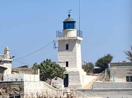 Îlot des Singes Light, Stora, August 2022
Google Maps photo by Sarah B |
- * Skikda (Philippeville) Traverse Nord
(2)
- Date unknown (station established about 1920). Active; focal plane 10 m
(33 ft); continuous red light. 8 m (26 ft) round tower with lantern and gallery, painted white; lantern painted red. This light is visible left of center in Chris Bouffandreau's photo and Google
has a satellite view. Located at the end of a short spur of the north jetty, opposite
the west jetty light (next entry). It is not known if the jetty can be
walked, but the lighthouse is easy to see from the waterfront. Tower
closed. ARLHS ALG-055; Admiralty E6523; NGA 22248.
- * Skikda (Philippeville) Jetée
Nord
- 1913. Active; focal plane 21 m (69 ft); white or red light, depending on
direction, occulting twice every 6 s. 14 m (56 ft) round masonry tower with
lantern and gallery, rising from a 1-story square base. Tower painted white,
lantern and gallery red. A 2023 photo is at right, a closeup 2024 photo is available, Cyril Preiss has a photo, Metatla Noureddine has a second photo, this light is visible on the left in Chris Bouffandreau's photo and in Mohamed Mezrani's photo, and Google has a satellite view. Located at the end of the long north jetty enclosing the old harbor
of Skikda. It is not known if the jetty can be walked, but the lighthouse
is easy to see from the waterfront. Tower closed. ARLHS ALG-047; Admiralty
E6522; NGA 22240.
- Port Methanier Jetée Principale (2)
- 2021 (station established 2009). Active; focal plane 16 m (52 ft); green flash every 4 s. 13 m (43 ft) tower. No photo available but Google has a satellite view. Port Methanier is a new commercial port on the east side of Skikda. In 2021 the original light, a tripod tower, was removed for extension of the breakwater. Located at the end of the main breakwater of the port. Site status unknown. Admiralty E6520; NGA 22252.
- Port Methanier Jetée Secondaire
- 2009. Active; focal plane 10 m (33 ft); red flash every 4 s. 7 m (23 ft) white round tower. No photo available but Google has a satellite view. Located at the end of the east breakwater of the port. Site status unknown. Admiralty E6520.2; NGA 22256.
- * Cap de Fer (Ra's el Hadid)
- 1859. Active; focal plane 65 m (213 ft); three white flashes every 15 s.
17 m (56 ft) round cylindrical tower with lantern and gallery, rising from
1-story keeper's house. Zinai Sabir's 2023 photo is at right, Abdesalem Bouaziz has a 2017 photo, Lightphotos.net has the ONSM photo, Lí Xiǎohuì has a closeup photo, Oud Zou has a 2022 view, and Google has a satellite
view. Located on a spectacular cape at the northern entrance to the
Golfe de Stora. Accessible by road. Site open, tower closed.
 . ARLHS ALG-011;
Admiralty E6516; NGA 22228. . ARLHS ALG-011;
Admiralty E6516; NGA 22228.
|
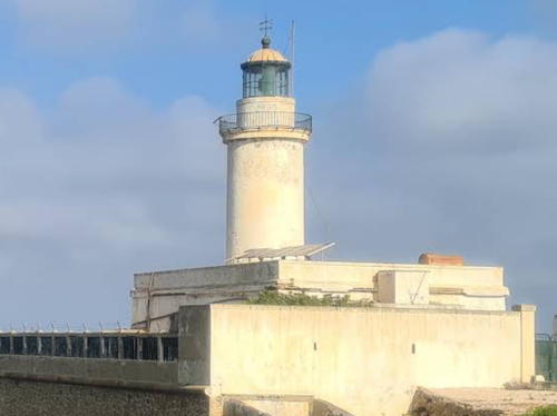 Cap de Fer Light, Skikda, August 2023
Google Maps photo by Open Nature Exploration |
- Ra's Takouch (Cap Takouch, Herbillon) (1)
- 1881. Inactive and abandoned. 12 m (39 ft) round stone tower with lantern and gallery attached to a 1-story keeper's house.
Tower originally painted white, lantern black. Fateh Bouchama's 2023 photo of the two towers is at right, Mehdi Derradji has a 2015 closeup photo,
and Google has a distant satellite view. Clearly endangered. Located atop a prominent headland about 2 km (1.2 mi) north
of Chetaïbi.
Site status unknown; the scarcity of photos suggests that this lighthouse
is not easy to visit. ARLHS ALG-017.
- Ra's Takouch (Cap Takouch, Herbillon) (2)
- Date unknown (station established 1881). Active; focal plane 128 m (420 ft); white or red light, depending
on direction, occulting once every 4 s. Approx. 16 m (52 ft) semi-elliptical cylindrical concrete tower.
Tower painted white. Fateh Bouchama's 2023 photo of the two towers is at right, a 2024 closeup of this tiower is available, Mehdi Derradji also has a photo showing both lighthouses, a distant view is available and Google has a distant satellite view. Located just behind the historic lighthouse.
Site status unknown; the scarcity of photos suggests that this lighthouse
is not easy to visit. Admiralty E6510; NGA 22216.
- * Chetaïbi East Breakwater (1)
- Date unknown. Inactive. Approx. 6 m (20 ft) white pyramidal white concrete tower. The tower is at the center distance in a photo of the harbor and Google has a satellite view. Located at an elbow of the east breakwater of Chetaïbi (both breakwaters have been extended). Site open, tower closed.
- * Chetaïbi East Breakwater (2)
- Date unknown. Active; focal plane about 15 m (49 ft); continuous green light. Approx. 12 m (39 ft) square skeletal tower painted white with a green top. The tower is right of center in a photo of the harbor and Google has a satellite view. Located at the end of the east breakwater of Chetaïbi. Site open, tower closed. Admiralty E6512; NGA 22220.
|
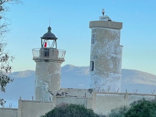 Old and new Ra's Takouch Lights, Chetaïbi, January 2023
Google Maps photo by Fateh Bouchama |
- * Chetaïbi West Breakwater (1)
- Date unknown. Inactive. Approx. 6 m (20 ft) white pyramidal white concrete tower. A photo is available, the tower is at the right in a photo of the harbor, and Google has an indistinct satellite view. Located at an elbow of the west breakwater of Chetaïbi (both breakwaters have been extended). Site open, tower closed.
- * Chetaïbi West Breakwater (2)
- Date unknown. Active; focal plane about 15 m (49 ft); continuous red light. Approx. 12 m (39 ft) square skeletal tower painted white with a red top. The tower is at right in a photo of the harbor and Google has an indistinct satellite view. Located at the end of the west breakwater of Chetaïbi. Site open, tower closed. Admiralty E6514; NGA 22224.
- Roche Akcine (Axin)
- Date unknown. Active; focal plane 16 m (62 ft); two white flashes every 6 s. 16 m (52 ft) tower, painted black with one red horizontal band. No photo available and the lighthouse is barely discernible in Bing's satellite view. Located on a reef about 1.2 km (3/4 mi) off a promontory about 10 km (6 mi) east of Chetaïbi. Accessible only by boat. Site open, tower closed. Admiralty E6508; NGA 22212.
Annaba Province Lighthouses- Another ancient city, Annaba was known as Hippo Regius in Roman times and as Bône under French rule. Today it is the largest port of eastern Algeria and the country's third largest city with a population of about 500,000.
* Cap
de Garde (2)- 1884 (station established 1841). Active; focal plane 143 m (469
ft); white flash every 5 s. 14 m (56 ft) square cylindrical stone
tower with lantern and gallery, attached to a 2-story stone keeper's
house. Wissam Salem's 2022 closeup photo is at right, Kamel Lebtahi has a closeup 2008 photo, Taky Benk has a 2016 photo, a 2006 view is available,
Wikimedia has several photos, Djaber Bouzitoune has a street view of the station, and Google has a satellite view. This is the landfall light for Annaba, located atop a
very prominent headland about 9 km (5.5 mi) north of Annaba. Site
open, tower probably closed.
 . ARLHS ALG-012; Admiralty
E6506; NGA 22208. . ARLHS ALG-012; Admiralty
E6506; NGA 22208.
|
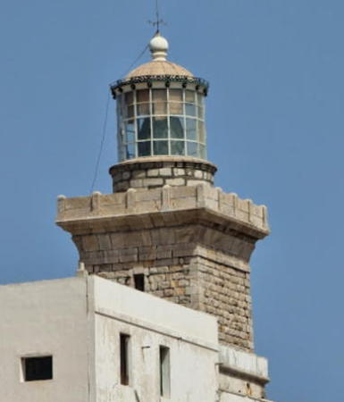 Cap de Garde Light, Annaba, September 2022
ex-Google Maps photo
by Wissam Salem |
- #Fort Génois (2?)
- Date unknown (station established 1841). Apparently demolished but listed with focal plane 61 m (200 ft); white light, occulting
twice every 6 s. 8 m (26 ft) "white tower with dwelling," according to NGA.
It seems clear that this lighthouse does not survive; a visitor in 2005 searched for it without success and local residents knew nothing of it. No lighthouse is seen in Google's satellite view of the listed location but there may be a modern beacon there. More information needed! Site
status unknown. ARLHS ALG-050; Admiralty E6504;
NGA 22204.
- * Annaba
(Bône) Jetée du Lion (2)
- Date unknown (station established 1841). Active; focal plane 16 m
(52 ft); green light, occulting three times every 12 s. 17 m (56 ft)
round cast iron tourelle with lantern and gallery, mounted on
a round masonry base. Tower painted white, lantern green. A 2024 photo is at right, Mohamedannabi Attia has a photo, another good photo (third photo in the top row of thumbnails) is available, Ramzi Hacham has a view from the sea,
and Google has a satellite view. Located at the end of
the jetty in Annaba. Site status unknown. ARLHS ALG-034; Admiralty
E6486; NGA 22176.
- * Annaba
(Bône) Jetée Sud
- 1880. Active; focal plane 16 m (52 ft); red light, occulting twice
every 6 s. 13 m (43 ft) white round tower, a typical French cast iron tourelle,
with lantern and gallery, mounted on a round concrete base. Oleksii Petrovich has a closeup photo and Google has a satellite view and a very distant street view. Baki Savaş Kuzkaya's 2023 photo shows the tower covered with rust and in need of restoration. Located at the end of the south jetty
in Annaba. Site status unknown. ARLHS ALG-035; Admiralty E6490; NGA
22180.
|
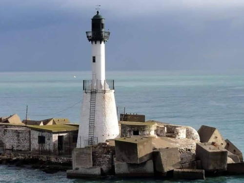 etée du Lion Light, Annaba, September 2024
Google Maps photo by marabout ski |
- Cap Rosa (Ra's Rosa)
- 1869. Active; focal plane 130 m (427 ft); two white flashes every
6 s. 13 m (43 ft) round stone or concrete tower with lantern and gallery.
Lighthouse painted white.
Lightphotos.net has a closeup photo, and Google has a satellite
view. Located on a headland about 25 km (15 mi) west of El Kala.
Site status unknown. ARLHS ALG-015; Admiralty E6484; NGA 22168.
- * El
Kala (La Calle)
- 1862. Active; focal plane 17 m (56 ft); continuous red light. 7.5
m (25 ft) round tower with lantern and gallery, rising from a 1-story
keeper's house. Building painted white, lantern red. Assad Adin's 2024 photo is at right, Régis
Corbet has a 2008 photo, a 2017 closeup is available, Ala Ati has a closeup street view, and Google has a satellite
view. El Kala is a fishing port at the northeastern corner of Algeria,
about 18 km (11 mi) west of the Tunisian border. Located on Pointe
Presqu'île, a short peninsula enclosing the north side of the
harbor. Site open, tower closed. ARLHS ALG-049; Admiralty E6482; NGA
22164.
Information available on lost lighthouses:
Notable faux lighthouses:
- #Bureau de la Santé, Philippeville (Skida). This tower has been listed by many sources as a lighthouse, but Michel Forand's research failed to find any evidence that it ever carried a light. The tower was on the quarantine office (Bureau de la Santé) at Philippeville. The building no longer exists.
|
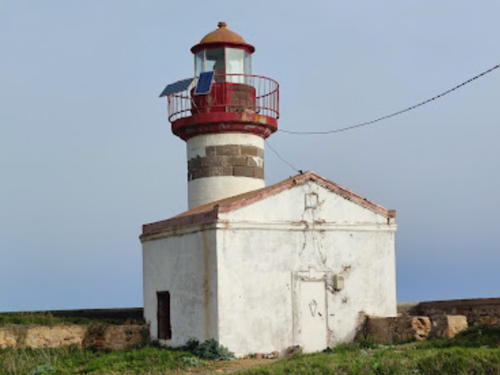
El Kala Light, El Kala, May 2024
Google Maps photo by Assad Adin
|
Adjoining pages: East: Northern Tunisia | West: Central Algeria
Return to the Lighthouse Directory
index | Ratings
key
Posted August 8, 2005. Checked and revised July 27, 2025.
Lighthouses: 36. Site copyright 2025 Russ Rowlett and the University of North
Carolina at Chapel Hill.
|
