Lighthouses of Spain: Western Galicia

The Kingdom of Spain occupies nearly 85% of the Iberian Peninsula in southeastern Europe with coastlines facing south and southeast on the Mediterranean Sea and southwest and northwest on the Atlantic Ocean. Spain also includes the Balearic Islands in the Mediterranean, the Canary Islands in the Atlantic, and the cities of Ceuta and Melilla on the north coast of Morocco.

Spain is divided into 17 regions called autonomous communities (comunidades autónomas). Galicia is an autonomous region in the northwestern corner of Spain. The Galician coastline is rugged and scenic but very dangerous to navigation; it is often called the "Coast of Death" (Costa da Morte in Galego). Many of the harbors are partly-sheltered bays called rías, actually the drowned lower valleys of rivers.

Galicia is divided into four provinces (provincias). This page includes lighthouses of the west coast of the region in southern and central A Coruña Province. The province is divided into county-level districts called comarcas. Lighthouses of the four northernmost districts of A Coruña Province are described on the Northern Galicia page.

Galicians speak Spanish or Galego, a distinctive language related to Portuguese. Galicia itself is called Galiza in Galego. The word for a lighthouse is faro in Spanish and farol in Galego, but its use is generally restricted to the larger coastal light stations. Smaller lighthouses are called balizas (beacons). In Galego illa is an island, cabo is a cape, punta is a promontory or point of land, rocha is a rock, arrecife is a reef, baía is a bay, ría is an estuary or inlet, estreito is a strait, río is a river, and porto is a port or harbor.

The navigational lights in Spain are the responsibility of the national port authority, Puertos del Estado, but many of them are operated and maintained by regional port authorities. The Comisión de Faros, founded in 1842 to build and maintain Spanish lighthouses, is now an advisory panel.

ARLHS numbers are from the ARLHS World List of Lights. ES numbers are from the Spanish national list of lights, Libro de Faros. Admiralty numbers are from volume D of the Admiralty List of Lights & Fog Signals. U.S. NGA List numbers are from Publication 113.

General Sources
Libro de Faros y Señales de Niebla
Online edition of the official Spanish light list.
Online List of Lights - Spain Atlantic Coast
Photos by various photographers posted by Alexander Trabas. Some of the photos for this area are by José Da Palma or Eckhard Meyer.
Faros de Galicia
A blog on Galician lighhouses posted by Marta Rivadulla.
Phares d'Europe
Photos and notes in French by Alain Guyomard and Robert Carceller.
Lighthouses in Spain
Excellent aerial photos posted by Marinas.com.
Lighthouses in Galicia
Photos by various photographers available from Wikimedia.
World of Lighthouses - Spain
Photos by various photographers available from Lightphotos.net.
Aids to Navigation
Information posted by the Porto de Vilagarcía.
Leuchttürme Spaniens auf historischen Postkarten
Historic postcard images posted by Klaus Huelse.
GPSNauticalCharts
Navigational chart for Galicia.
Navionics Charts
Navigational chart for Galicia.

Torre de Hércules
Torre de Hércules, A Coruña, August 2011
Flickr Creative Commons photo by José Luis Cernadas Iglesias

A Barbanza District Lighthouses
The southernmost comarca of A Coruña, A Barbanza lies on the north side of the harbor of the Ría de Arousa. Lighthouses on the south side of the ria and in the port of Vilagarcía de Arousa are described on the Southern Galicia page.

Bajo Sinal de Ostreira
Date unknown. Active; focal plane 10 m (33 ft); red flash every 5 s. 10 m (33 ft) round stone tower with gallery, painted white with a red band around the top. Trabas has Meyer's photo and Google has a satellite view. Located on the west side of the Ría de Arousa off the small harbor of A Pobra de Caramiñal. Accessible only by boat. Site open, tower closed. Operator: Porto de Vilagarcía. ES-04280; Admiralty D1828; NGA 2776.
Isla Rúa
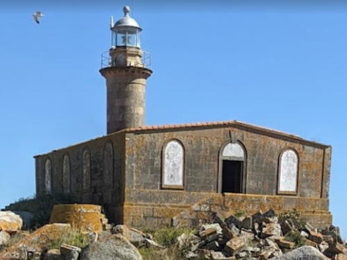
1869. Active; focal plane 26 m (85 ft); three white flashes in a 2+1 pattern every 21 s; red flashes are shown in a sector to the south and southeast. 14 m (46 ft) round cylindrical granite tower with lantern and gallery, embedded in one end of a 1-story keeper's house. The buildings are unpainted; lantern dome is gray metallic. José Manuel Hermo González has a photo (also seen at right), Trabas has Meyer's photo, Michel Forand has a historic postcard view, Luis Navia has a street view, and Google has a satellite view. Located on a small rocky island in the Ría de Arousa about 5 km (3 mi) east of Ribeira. Accessible only by boat. Site and tower closed. Operator: Porto de Vilagarcía. ARLHS SPA-156; ES-04160; Admiralty D1818; NGA 2756.
Piedras del Sargo
Date unknown. Active; focal plane 13 m (43 ft); quick green flash every 1 s. 12 m (39 ft) round stone tower with gallery, painted white with a green band around the top. Trabas has a photo and Google has a satellite view. Located on a reef on the north side of the entrance to the Illa de Arousa. Accessible only by boat. Site open, tower closed. Operator: Porto de Vilagarcía. ES-04140; Admiralty D1798; NGA 2732.

Isla Rúa Light, Ribeira, July 2022
Google Maps photo by José Manuel Hermo González
Illa de Sálvora (Isla de Sálvora) (2)
1921 (station established 1852). Active; focal plane 38 m (125 ft); four white flashes in a 3+1 pattern every 20 s; the fourth flash is omitted in a sector to the northwest. 16 m (52 ft) octagonal stone tower with lantern and gallery, attached to the front of a U-shaped 1-story keeper's house. Tower painted white with one narrow horizontal red band; lantern dome is gray metallic; house painted white. Trabas has Meyer's distant photo, Fernando Sacó has a street view, Guyomard and Carceller have a good closeup photo, Fran García has three photos taken from the sea, Michel Forand has a historic postcard view, and Google has a satellite view. The Isla de Sálvora is a rocky island, about 2 km (1.2 mi) long, in the center of the entrance to the Ría de Arousa, which leads to the port of Vilagarcía. In 2002 the island was included with several others in a new national park. Located at the southern point of the island. Accessible only by boat; tours of the island can be arranged from Ribeira. Site open, tower closed. Operator: Porto de Vilagarcía. Site manager: Parque Natural de las Islas Atlánticas. . ARLHS SPA-157; ES-04120; Admiralty D1796; NGA 2724.
* Corrubedo
1854. Active; focal plane 32 m (105 ft); five white flashes in a 3+2 pattern every 20 s; red flashes are shown in a sector to the south. 14 m (46 ft) round granite tower with lantern and gallery, mounted atop a semicircular 1-story masonry keeper's house. A large Fresnel lens is in use. Tower unpainted; lantern is metallic gray; house painted white. Fog siren (three 5 s blasts every 60 s). A photo by Nelson Fernández is at right, Trabas has a closeup, a photo shows the lighthouse in action, Marinas.com has aerial photos, and Google has a closeup street view and a satellite view. Cabo Corrubedo is the most dangerous Spanish cape south of Finisterre, since it projects far into the sea and the ridge continues underwater as a series of shoals. The unusual semicircular design of the keeper's house was meant to minimize wind resistance. Located on the point of the cape, at the end of the AC-303 highway, about 1.5 km (1 mi) due west of the town of Corrubedo. Site open, tower closed. Operator: Porto de Vilagarcía. . ARLHS SPA-012; ES-04100; Admiralty D1794; NGA 2716.

Corrubedo Light, Ribeira, May 2016
Google Maps photo by Nelson Fernández

Noia District Lighthouse
* Punta Cabeiro (Caveiro)
Date unknown. Active; focal plane 37 m (121 ft); white or red light depending on direction, 2.2 s on, 0.8 s off. 4 m (13 ft) square stone tower; the lights were origianlly shown through a window but they have now moved atop the tower. Trabas has Meyer's photo, a 2019 photo is available, and Google has an indistinct satellite view. The light stands within a popular viewpoint (mirodoiro). Located on a headland on the east side of the Ría de Muros y Noia. Site open, tower closed. ES-04080; Admiralty D1792; NGA 2700.

Muros District Lighthouses
The comarca of Muros occupies a mountainous headland on the north side of the Ría de Muros y Noia. Its population is about 12,500.

* Cabo Rebordiño
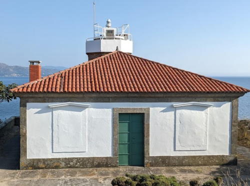
1909 (Salvador López Miño). Active; focal plane 18 m (59 ft); two red flashes every 7 s. 8 m (26 ft) round cylindrical cast iron tower with lantern and gallery, attached to the front of a 2-story keeper's house. Tower painted white; lantern dome is silvery metallic; house painted white with unpainted stone trim and a red roof. Antonio Sanchez has an excellent photo, Sergio Arines Ferreiros has a similar 2022 photo, Trabas has Meyer's closeup photo, Michel Forand has a historic postcard view, and Google has a satellite view and a closeup street view. This is a typical tourelle, almost certainly prefabricated in France. An unusual feature of ths lighthouse is a footbridge connecting the gallery to the flat roof of the keeper's house. Located on an east-pointing promontory, beside the AC-550 highway about 1 km (0.6 mi) southeast of Muros, marking the entrance to the harbor of that town. Site open, tower closed. Operator: Porto de Vilagarcía. . ARLHS SPA-040; ES-04000; Admiralty D1786; ex-NGA 2692.
* Monte Louro (Punta Queixal)
1862. Active; focal plane 27 m (89 ft); three white flashes in a 2+1 pattern every 12 s. 7 m (23 ft) hexagonal granite tower with lantern and gallery, attached to the front of a small 1-story keeper's house. Tower unpainted; lantern dome painted white; house painted white with unpainted stone trim and a red roof. A photo by Eladio Anxo Fernández Manso is at right, Trabas has a great photo, Victor Bao has a 2011 photo, a 2012 photo is available, Marinas.com has aerial photos, and Google has a street view and a satellite view. The lighthouse stands at the end of a south-pointing peninsula that shelters the northern entrance to the Ría de Muros e Noia. Located about 3 km (2 mi) south of Louro. Site open, tower closed. Operator: Porto de Vilagarcía. . ARLHS SPA-182; ES-03990; Admiralty D1784; NGA 2688.
** Punta Ínsua (Lariño)
1921 (Salvador López Miño). Active; focal plane 27 m (89 ft); three flashes every 9 s, white or red depending on direction. 14 m (46 ft) octagonal cylindrical stone tower with lantern and gallery, attached to the rear of a 1-story keeper's house. Tower unpainted; lantern is silvery metallic; house painted white with unpainted stone trim and a red roof. A photo by José Antonio Gil Martínez is at right, Trabas has an excellent photo, Guyomard and Carceller have also posted a photo, Víctor M. Cochón Canosa has a 2018 closeup, a 2021 photo is available, and Google has a closeup street view and a satellite view. This lighthouse was completed in 1913 but it was not activated until after the end of World War I. Its light filled in a dark zone between Capes Corrubedo and Finisterre. The lighthouse has been renovated as a boutique hotel; it opened in 2021. Located on a headland at Lariño. Site open, tower closed. Site manager: Hotel Faro de Lariño. Operator: Porto de Vilagarcía. . ARLHS SPA-235; ES-03980; Admiralty D1782; NGA 2684.
Islote Lobeira Grande
1909. Active; focal plane 18 m (59 ft); three white flashes every 15 s. 10 m (33 ft) octagonal cylindrical stone tower with lantern and gallery, attached to the front of a 2-story keeper's house. The building is unpainted; lantern painted white. Juan Manuel Lado Castro has a photo, José Pérez has a 2020 closeup, Carlos Abella Rey has a photo, Trabas has a long-range photo, and Google has a satellite view. One recent visitor reported that the keeper's house is ruined inside. Located on a small, rocky island about 4 km (2.5 mi) due south of Cabo Cée. Accessible only by boat. Site open, tower closed. Operator: Autoridad Portuaria de A Coruña. . ARLHS SPA-168; ES-03920; Admiralty D1756; NGA 2680.

Monte Louro Light
Monte Louro Light, Muros, July 2010
Flickr Creative Commons photo
by Eladio Anxo Fernández Manso


Punta Ínsua Light, Lariño, June 2006
Flickr Creative Commons photo by José Antonio Gil Martínez


Fisterra District (Cabo Finisterre Area) Lighthouses
The comarca of Fisterra (Finisterre) includes the rugged westernmost land of Spain. The district has a population of about 22,000.

Carrumeiro Chico
1917. Active; focal plane 8 m (26 ft); two white flashes every 7 s. 8 m (26 ft) round solid stone tower with a lantern structure and gallery. Tower painted with red and black horizontal bands. Trabas has Meyer's photo and Google has a satellite view. Located on a shoal in the entrance to Cabo Cée harbor, about 1.1 km (0.7 mi) southeast of the Cabo Cée lighthouse. Accessible only by boat. Site open, tower closed. Operator: Autoridad Portuaria de A Coruña. ARLHS SPA-025; ES-03940; Admiralty D1758; NGA 2676.
* Cabo Cée (Corcubión)
1860. Active; focal plane 27 m (89 ft); five white flashes every 13 s. 8 m (26 ft) octagonal cylindrical granite tower with lantern and gallery, attached to the front of a 1-story keeper's cottage. The lantern has been replaced by a modern solar-powered lamp. Tower unpainted; house painted white with unpainted stone trim. Jorge Garcia Rey has the 2021 photo at right, the Concello de Corcubión (regional council) has a good photo, Trabas has Meyer's closeup photo, Juan R. Fabeiro has a view from the sea, Juan Manuel Lado Castro has a photo of the light in action, Huelse has a historic postcard view, and Google has a closeup street view and a satellite view. Located at the end of the peninsula marking the west entrance to the Ría de Corcubión, about 8 km (5 mi) south of Cée. Accessible by road; limited parking provided. Site open, tower closed. Operator: Autoridad Portuaria de A Coruña. . ARLHS SPA-011; ES-03930; Admiralty D1760; NGA 2668.

Cabo Cée Light, Corcubión, August 2021
Google Maps photo by Jorge Garcia Rey
* Cabo Finisterre (Cabo Fisterra)
1853. Active; focal plane 143 m (469 ft); white flash every 5 s. 17 m (56 ft) octagonal cylindrical granite tower with lantern and gallery attached to the front of a 2-1/2 story keeper's house. Tower unpainted; lantern is silvery metallic; house painted white with unpainted stone trim. Fog siren (two blasts every 60 s). The 2-story fog signal building is operated as the Hotel O Semáforo. Gabriele Margapoti's photo appears at right, Trabas has José da Palma's photo, Wikimedia has many photos, Lurdes Sagq has a 2020 photo, Fran García has good photos, a fine closeup is available, Marinas.com has aerial photos, Forand has a historic postcard view, Enrique de la Torre has a street view, and Google has a satellite view. This is one of Spain's most famous lighthouses, standing at the end of a narrow, south-pointing promontory with a spectacular view of the Atlantic. Although Cabo Toriñana (see next entry) actually extends a little farther west, Cape Finisterre is the traditional "land's end" at the northwestern corner of Spain. (Cabo da Roca in Portugal is about 16.5 km (10.3 mi) further west and is the westernmost point of continental Europe.) Cape Finisterre is the ending point of the Camiño de Santiago (the Way of St. James), a traditional route of pilgrimage that extends 90 km (56 mi) from the Cathedral of Santiago de Compostela. The lighthouse is the second most visited tourist destination in Galicia, after the Cathedral. The early history of the station is not well known, but there are reports of lights displayed on the cape as early as 1673. Located at the end of the AC-445 highway about 3 km (2 mi) south of Fisterra. Accessible by road; limited parking provided. Site open, tower closed. Operator: Autoridad Portuaria de A Coruña. . ARLHS SPA-026; ES-03900; Admiralty D1742; NGA 2664.

Cabo Finisterre (Fisterra) Light, Cée, August 2009
Flickr Creative Commons photo by Gabriele Margapoti
* Cabo Toriñana (Cabo Touriñán) (1)
1898. Inactive since 1981. 8 m (26 ft) tower with lantern and gallery centered on the roof of a square 1-story keeper's house. Building painted with with unpainted stone trim; roof is gray. Arturo Nikolai's photo appears at right, Fran García has excellent closeup photos, Marinas.com has aerial photos, and Google has a closeup street view and a satellite view. This lighthouse stands on the westernmost point of Spain at 9°17.9' W, extending about 2.1 km (1.33 mi) farther west than Cabo Finisterre. Located on the point of the cape about 3 km (2 mi) northwest of Toriñana (Touriñán). Site open, tower closed. ARLHS SPA-330.
* Cabo Toriñana (Cabo Touriñán) (2)
1981 (station established 1898). Active; focal plane 65 m (213 ft); three white flashes in a 2+1 pattern every 15 s. 11 m (36 ft) round cylindrical concrete tower with lantern and double gallery, painted white. Arturo Nikolai's photo is at right, Trabas has Meyer's closeup photo, Wikimedia has a photo, and Selva de Esmelle has a good photo. This is one of a series of modern lighthouses of a standard design built throughout Galicia beginning in the early 1970s. Located adjacent to the original lighthouse. Accessible by road; limited parking provided. Site open, tower closed. Operator: Autoridad Portuaria de A Coruña. . ARLHS SPA-049; ES-03880; Admiralty D1740; NGA 2660.
* Punta de la Barca (Muxía)
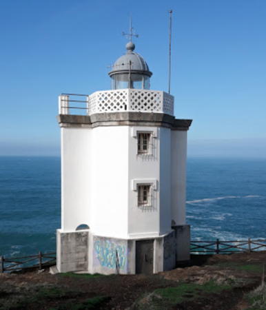
1928. Active; focal plane 13 m (43 ft); white light occulting once every 4 s. 11 m (36 ft) unpainted round concrete tower with double gallery. Trabas has Meyer's closeup photo, a 2022 photo is available, and Google has a street view and a satellite view. This light marks the southern entrance to the Ría de Camariñas. Located on a sharp cape at the end of the Calle de la Virxe de la Barca on the north side of Muxía. Accessible by road, parking provided. Site open, tower closed. Operator: Autoridad Portuaria de A Coruña. . ARLHS SPA-210; ES-03810; Admiralty D1737; NGA 2656.
Faros de Cabo Touriñan
Cabo Touriñán Light, Muxía, June 2007
Flickr Creative Commons photo
by Arturo Nikolai
* Punta Laxe (Punta de Lago) (Range Front)
Date unknown. Active; focal plane 15 m (49 ft); two flashes every 6 s, white, red or green depending on direction. 7 m (23 ft) round concrete tower, painted white. Trabas has Meyer's photo, another photo is available, Loly Mato Pedrido has a 2022 photo showing both range lighthouses, and Google has a street view and a satellite view. Michel Forand has a historic postcard view that shows the tower with its original lantern. This is the entrance range light for the Ría de Camariñas. Located on the east side of the bay, about 2.5 km (1.5 mi) northeast of Merexo. Site open, tower closed. . ARLHS SPA-290; ES-03830; Admiralty D1738; NGA 2636.
* Punta Laxe (Punta de Lago) Range Rear
Date unknown. Inactive. 8 m (26 ft) round concrete tower, painted white. Google has a street view and a satellite view. The light was deactivated when the directional light was installed on the front tower, but this tower continues to be maintained as a dayrange beacon. Located about 120 m (130 yd) east southeast of the front light. Site open, tower closed. ES-03831.

Terra de Soneira District Lighthouses
* Cabo Vilán (Villano) (1)
1854 (Francisco Lizárraga and Adolfo Pequeño). Inactive since 1896. 7 m (23 ft) round cylindrical stone tower atop an octagonal pyramidal stone base. A closeup photo is available, Rivadulla's page has photos (halfway down the page), Agustin Alejandro Guevara Bermudez has a street view, and Google has a satellite view. This first Cabo Villano light had a focal plane of 74 m (243 ft), but it had to be replaced because its light was obscured for ships approaching from the north. Located on the hilltop above the modern light. Site open, tower closed. ARLHS SPA-329.
*** Cabo Vilán (Villano) (2)
1896 (station established 1854). Active; focal plane 104 m (341 ft); two white flashes every 15 s. 25 m (82 ft) octagonal stone tower with lantern and gallery; 1st order Fresnel lens. The lighthouse is unpainted yellow-brown stone; lantern is all glass including the dome. Fog siren (Morse code "V": three short blasts followed by one long blast, every 60 s). The 2-story keeper's house complex has been renovated as a museum. A photo is at right, Trabas has an excellent photo, Wikimedia has numerous photos, Lighthouse Digest has a good photo by José Ramón Matos Prego, Garabatos San Vicente has a 2022 photo, Forand has a historic postcard view, and Google has a street view and a satellite view. This is the northernmost of several historic first-order lighthouses that light the way around Cabo Finisterre, the northwestern corner of Spain. The light has a range of 45 km (28 mi). Note: the lighthouse at Gorlíz, Vizcaya, is located on another Cabo Villano. Located atop a steep promontory at the point of the cape, about 6 km (3.5 mi) northwest of Camariñas on the AC 432 highway. Accessible by road; limited parking provided. Site open, tower closed. Site manager: Museo del Faro. . ARLHS SPA-056; ES-03800; Admiralty D1736; NGA 2632.

Bergantiños District Lighthouses
* Punta Lage (Punta Laxe)
1920. Active; focal plane 66 m (217 ft); five white flashes every 20 s. 11 m (36 ft) round cylindrical brick tower with gallery, painted white. Lourdes Cancela has a 2020 photo, Trabas has Meyer's closeup photo and Google has a street view and a satellite view. This lighthouse marks the south entrance to the Ría de Corme y Lage. The light was upgraded in 1995 with a new, more powerful lens. Near the lighthouse is a sculpture by Iria Rodríguez, "A Espera," of a woman waiting for the return of a sailor perhaps lost at sea. Located on a north-pointing headland at the end of the Camiño Cemiterio about 2.5 km (1.5 mi) north of Laxe (Lage). Accessible by road, parking provided. Site open, tower closed. Operator: Autoridad Portuaria de A Coruña. . ARLHS SPA-238; ES-03760; Admiralty D1732; NGA 2628.

Cabo Vilán Light, Camariños, February 2009
ex-Flickr Creative Commons photo by Pablo Charlón
* Punta de Roncudo
1920. Active; focal plane 38 m (125 ft); white flash every 6 s. 11 m (36 ft) round cylindrical brick tower with gallery, painted white. Trabas has a good photo, Miguel Asensi has a photo, and Google has a street view and a satellite view. This lighthouse is a twin of the Punta Lage lighthouse; it marks the end of a westward-pointing promontory and the north entrance to the Ría de Corme y Lage. Located at the end of the AC 424 highway about 6 km (3.5 mi) west of Corme Puerto. Accessible by road, parking provided. Site open, tower closed. Operator: Autoridad Portuaria de A Coruña. . ARLHS SPA-228; ES-03750; Admiralty D1730; NGA 2616.
* Punta Nariga
1998 (César Portela). Active; focal plane 55 m (180 ft); four white flashes in a 3+1 pattern every 20 s. 39 m (128 ft) round cylindrical masonry tower with lantern and gallery, rising from the center of a triangular equipment room and mounted on a rhomboidal foundation designed to resemble the prow of a ship. Lighthouse is unpainted white concrete block. A photo is at right, Trabas has a closeup photo, Óscar Villán has another good photo, Wikimedia has several photos, and Google has a street view and a satellite view. This modern lighthouse also carries sculptures by the Galician sculptor Manolo Coia. Located on a rocky headland in Malpica de Bergantiños, about 8 km (5 mi) northwest of Mens. Accessible by road, parking provided. Site open, tower closed. Operator: Autoridad Portuaria de A Coruña. . ARLHS SPA-072; ES-03735; Admiralty D1729; NGA 2613.
Illas (Islas) Sisargas (3)
1915 (station established 1853). Active; focal plane 110 m (361 ft); three white flashes every 15 s. 10 m (33 ft) octagonal granite tower with lantern and gallery, rising from the center of a large rectangular keeper's house complex. 1st order Fresnel lens. Tower is unpainted stone; lantern dome is grayish white; house painted white with a red roof. Fog siren (three 3 s blasts every 30 s). Rivadulla has a page for the lighthouse, Trabas has Jose da Palma's closeup photo, another photo is available, Peter Droogers has a street view, and Google has a satellite view. A temporary lighthouse was used from 1911 and 1915 while the original lighthouse was rebuilt; the Puertos del Estado page says the present light tiene muy poco que ver (has very little to do) with the present building. Near the lighthouse are the ruins of the hermitage of Santa Mariña, which was shelled by Francis Drake in 1589. The Islas Sisargas are rocky islands off Cabo de San Adrián, a prominent and dangerous cape about 35 km (22 mi) west of La Coruña. The islands are a protected wildlife refuge. Located on Sisarga Grande, largest of the islands, about 5 km (3 mi) northwest of Malpica de Bergantiños. Accessible only by boat, but there is a view from the point of Cabo de San Adrián. Site and tower closed. Operator: Autoridad Portuaria de A Coruña. ARLHS SPA-162; ES-03730; Admiralty D1728; NGA 2612.

Punta Nariga Light, Malpica de Bergantiños, September 2014
Wikimedia Creative Commons photo by Mussklprozz

A
Coruña District Lighthouses
A Coruña (La Coruña in Spanish and historically called Corunna in English) is the provincial capital and the most populous city of Galicia with a population of about 250,000. Called Brigantium in Roman times, it has a long and distinguished history as a seaport and naval base. The city is built on a narrow peninsula that shelters a magnificent natural harbor.
**** Torre de Hércules
Early 2nd century AD (extensively reconstructed in the late 1700s). Active; focal plane 106 m (348 ft); four white flashes every 20 s. 49 m (161 ft) square cylindrical stone tower, incorporating keeper's quarters, surmounted by an octagonal stone watchroom, lantern and gallery. The tower is unpainted dark gray stone; lantern is black. Many photos are available, including the photo by José Luis Cernadas Iglesias at the top of this page, over 150 photos from Wikimedia, another great photo posted by Trabas, Felipe Lata Raposo's 2022 closeup photo, and aerial photos by Marinas.com; in all the photos notice the internal spiral structure of the building. Rivadulla has a page for lighthouse, Huelse has a historic postcard view and Google has a street view and a satellite view. This is the world's oldest active lighthouse and one of its most famous and most historic. The original construction date of the lighthouse is not known, but an inscription found near the original foundation mentions an architect known to have been active in Spain during the rule of the Emperor Trajan (98-117 AD). At that time A Coruña was the Roman city of Brigantium. The lighthouse was abandoned during the Dark Ages after the fall of Rome, but it was put back in service by the 13th century, when A Coruña became an important port. By the 17th century, however, the lighthouse was a quaint ruin, and efforts were made to shore it up. Complete restoration had to wait until 1785, when King Carlos III ordered a reconstruction. What was left of the Roman structure was patched up and encased in new granite masonry, and the tower was extended in height with an octagonal second stage and the octagonal watch room. Today the lighthouse is the symbol of A Coruña and one of the most visited tourist attractions in Galicia. It is called the Tower of Hercules because of an old legend that Hercules himself built it. In June 2009 the tower was named a UNESCO World Heritage Site; UNESCO calls the lighthouse "unique as it is the only lighthouse of Greco-Roman antiquity to have retained a measure of structural integrity and functional continuity." Located in the Parque de la Torre at the northern end of the peninsula on whch A Coruña is built, nearly surrounded by water and with a sweeping view of the open Atlantic. Ample parking available. Site and tower open daily; the gallery is closed in high winds. Owner/site manager: Concello da Coruña. . ARLHS SPA-276; ES-03530; Admiralty D1704; NGA 2548.
* Castelo (Castillo) de San Antón
1872. Active; focal plane 17 m (56 ft) two green flashes every 7 s. 6 m (20 ft) masonry tower with lantern. Tower is unpainted stone; lantern is dark green metallic. A photo is at right, Emilio Fernández has a 2018 photo, Trabas has Erich Hartmann's photo, Carlos J. Escudero has a street view, and Google has a satellite view. The Castillo de San Antón is built on a small island blocking access to the inner harbor of A Coruña. Construction began in 1587 and the unfinished fortress saw action against Sir Frances Drake's raid in 1589. Used for much of the 20th century as a prison, the fortress was converted to an archeological and historical museum in 1964. The lighthouse is located near the eastern end of the fortress, which is now joined to the city by a causeway promenade. Site and fortress open daily, tower closed. Owner: Concello da Coruña. Site manager: Museo Arqueoloxía e Histórico Castelo de San Antón. . ARLHS SPA-062; ES-03600; Admiralty D1716; NGA 2572.

Castelo de San Antón Light, A Coruña, November 2007
Wikimedia Creative Commons photo by Jaimeluisgg
* Oza
1917. Inactive since 1963. 7 m (23 ft) octagonal stone tower centered on the flat roof of a 1-story keeper's cottage. House painted white; a metal enclosure protects the lantern. Wikimedia has several photos, Juan Fernán Bello has a 2018 photo, Marina Laura Fernández López has a 2022 photo, Sieteveinte Grados has a street view, and Google has a satellite view. From 1932 to 1955 this was the front light of a range guiding ships into the harbor of A Coruña. The range was abandoned when development of the port required a different line of approach, the Punta Fieiteira Range. The port authority secured the building in 1997. There have been various proposals to restore it, none accepted so far. Located south of the port area off the Avenida del Pasaje. Site open, tower closed. . ARLHS SPA-328.
Punta Fieiteira Anterior (Faro de Santa Cristina)
1963(?). Active; focal plane 29 m (95 ft); white, red, or green light depending on direction, 1 s on, 1 s off. 10 m (33 ft) semicircular cylindrical rubblestone tower. The tower is unpainted, but the entire front face is covered by a daymark painted with red and white horizontal bands. Trabas has a closeup photo, Jorge Santos has a 2020 photo of the unpainted rear of the tower, and Google has a satellite view. Ships entering A Coruña follow the Punta Mera range to the middle of the entrance of the Ría da Coruña and then turn 74° to the right onto the Punta Fieiteira Range. Located on a headland in Perillo, at the southern end of the Ría de la Coruña. Site status unknown; it's not clear if this area is open to the public. ARLHS SPA-292; ES-03560; Admiralty D1710; NGA 2560.
* Punta Fieiteira Posterior
1963(?). Active; focal plane 54 m (177 ft); red light occulting once every 4 s. 10 m (33 ft) semicircular cylindrical rubblestone tower, attached to a 1-story equipment room. The light is on a tall mast at the top of the tower. The tower is unpainted, but the entire front face is covered by a daymark painted with red and white horizontal bands; the mast is also painted with red and white horizontal bands. Trabas has Meyer's photo and Google has a street view and a satellite view. Located on the Rúa Cubelos in Perillo on the west side of the Rúa Miradoiro. Streetside parking is available. Site probably open, tower closed. ARLHS SPA-293; ES-03561; Admiralty D1710.1; NGA 2564.
* Punta Mera Anterior
1918. Active; focal plane 56 m (184 ft); white or red light, depending on direction, occulting once every 4 s. 11 m (36 ft) octagonal tower with lantern and gallery, painted white. Raquel Pires Alejandro's photo is at right, Trabas has Meyer's closeup photo, Lighthouse Digest has a good closeup photo by José Ramón Matos Prego, Mario Montero has a 2017 closeup, and Google has a satellite view. The range guides ships on the initial approach to La Coruña. Located on a headland in Oleiros at the eastern side of the entrance to the Ría de la Coruña, 1.5 km (1 mi) west of Mera. Accessible by road, parking provided. Site open, tower closed. . ARLHS SPA-243; ES-03550; Admiralty D1706; NGA 2552.
* Punta Mera Posterior
1918. Active; focal plane 81 m (266 ft); white flash every 4 s. 14 m (46 ft) octagonal tower with lantern and gallery, painted white. Trabas has Meyer's closeup photo, Wikimedia has a photo by Carlos de Paz, Manuel Garcia has a good photo, Fernando López-Azcárate Fdez has a 2021 photo, and Google has a street view and a satellite view. Located on the Rúa Emilio Ferreiro, 300 m (985 ft) east southeast of the front light. Accessible by road, but no parking is provided. Site open, tower closed. ARLHS SPA-295; ES-03551; Admiralty D1708; NGA 2556.

Punta Mera Anterior Light, Oleiros, February 2020
Google Maps photo by Raquel Pires Alejandro

Information available on lost lighthouses:

Notable faux lighthouses:

Adjoining pages: North: Northern Galicia | South: Southern Galicia

Return to the Lighthouse Directory index | Ratings key

Posted December 2, 2005. Checked and revised July 15, 2023. Lighthouses: 31. Site copyright 2023 Russ Rowlett and the University of North Carolina at Chapel Hill.