Lighthouses of Spain: Murcia

The Kingdom of Spain occupies nearly 85% of the Iberian Peninsula in southeastern Europe with coastlines facing south and southeast on the Mediterranean Sea and northwest on the Atlantic Ocean. Spain also includes the Balearic Islands in the Mediterranean, the Canary Islands in the Atlantic, and the cities of Ceuta and Melilla on the north coast of Morocco.

Since 1978 Spain has been divided into 17 regions called autonomous communities (comunidads autónoma) that have been granted varying degrees of autonomy by the central government. The autonomous communities are subdivided into provinces (provincias). This page includes lighthouses of the autonomous community of Murcia (formally the Región de Murcia); it is an autonomous community as well as a province. Its coastline faces southeast on the Mediterranean, bordering Andalusia to the south and the Valencian Community to the north.

The word for a lighthouse is faro in Spanish but its use is generally restricted to the larger coastal light stations. Smaller lighthouses are called balizas (beacons). In Spanish isla is an island, cabo is a cape, punta is a promontory or point of land, péñon is a rock, arrecife is a reef, bahía is a bay, ría is an estuary or inlet, estrecho is a strait, río is a river, and puerto is a port or harbor.

The navigational lights in Spain are the responsibility of the national port authority, Puertos del Estado, but many of them are operated and maintained by regional port authorities. The Comisión de Faros, founded in 1842 to build and maintain Spanish lighthouses, is now an advisory panel.

ARLHS numbers are from the ARLHS World List of Lights. ES numbers are from the Spanish national list of lights, Libro de Faros. Admiralty numbers are from volume E of the Admiralty List of Lights & Fog Signals. U.S. NGA List numbers are from Publication 113.

General Sources
Libro de Faros y Señales de Niebla
Online edition of the official Spanish light list.
Online List of Lights - Spain - Southeast Coast
Photos by various photographers posted by Alexander Trabas. Some of the photos for this coast are by Capt. Peter Mosselberger ("Capt. Peter").
Phares d'Europe
Photos posted by Alain Guyomard and Robert Carceller.
Lighthouses, Islands and Capes
This collection of photos by José Miralles Pol has some fine photos of lighthouses in this area.
Spain Lighthouses
Fine aerial photos posted by Marinas.com.
Lighthouses in Spain
Photos by various photographers available from Wikimedia.
World of Lighthouses - Spain
Photos by various photographers available from Lightphotos.net.
Luces para la Navegacíon
Photos and accounts posted by the regional government of Murcia.
Spanische Leuchttürme auf historischen Postkarten
Historic postcard images posted by Klaus Huelse.
GPSNauticalCharts
Navigational chart information for Spain's Mediterranean coast.
Google Maps
Satellite view of Murcia.


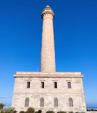
Cabo de Palos Light, Cabo de Palos, December 2022
Google Maps photo by El Comandante
Lighthouses in Murcia are operated and maintained by the Autoridad Portuaria de Cartagena. The region's principal seaport, Cartagena, is a historic city founded by Carthaginians in the third century BCE; for centuries it has been the home port of Spain's Mediterranean Fleet. The coast of Murcia is called the Costa Cálida (Warm Coast).

Mar Menor Lighthouses
The Mar Menor ("Minor Sea") is a triangular saltwater lagoon north of the Cabo de Palos in northeastern Murcia. The lagoon is sheltered from the Mediterranean Sea by a sandy barrier called La Manga ("The Sleeve"), 21 km (13 mi) long. Breaks in the barrier are called golas ("throats" in Catalan).

* El Estacio (2)
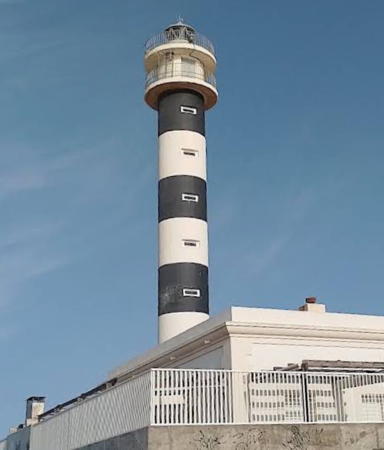
1976 (station established 1862). Active; focal plane 32 m (105 ft); four white flashes every 20 s. 29 m (95 ft) round cylindrical concrete tower with lantern and double gallery, painted with black and white horizontal bands. The original (1862) keeper's house survives. Ruut Nieminen's 2022 photo is at right, Trabas has a 2006 photo, Wikimedia has a fine photo, Alberto Lopez also has a photo, and Google has a street view and a satellite view. Sibling of the 1973 Águilas lighthouse (see below). The original lighthouse was a 15 m (49 ft) octagonal masonry tower designed by Carlos Mondéjar. The lighthouse is located midway along the La Manga barrier at the Punta del Estacio, on the north side of an inlet that gives access to the Mar Menor. The site is accessible by road from Cabo de Palos. Site open, tower closed. ARLHS SPA-088; ES-23950; Admiralty E0140; NGA 4624.
[Isla Grosa]
Date unknown. Active; focal plane 97 m (318 ft); white flash every 3 s. 4 m (13 ft) mast atop a round white concrete base. Trabas has a very distant 2012 view from shore and Google has a satellite view. Located at the summit of Isla Grosa, a very steep rocky island about 2 km (1.25 mi) southeast of the entrance to the Mar Menor. Inaccessible; site and tower closed. ES-23900; Admiralty E0139; NGA 4628.
Los Alcázares (Infanta Cristina Pier)
Date unknown. Active; focal plane about 8 m (26 ft); light characteristic unknown. 7 m (23 ft) mast atop a 1-story harbor control office. Trabas has a 2012 photo, Laura García has a view from the shore, and Google has a satellite view. Located at the end of the main pier at Los Alcázares, a resort town on the west (mainland) side of the Mar Menor. Probably accessible by walking the pier. Site open, tower closed. ES-23970; Admiralty E0141.28.

Campo de Cartagena Lighthouses
Las Hormigas (Hormiga Grande)
1862 (Carlos Mondéjar). Active; focal plane 24 m (79 ft); three white flashes every 14 s. 12 m (39 ft) round cylindrical masonry tower with lantern and gallery, centered on the roof of a circular masonry keeper's house. Entire lighthouse painted white. José Francisco Calvo has a 2017 photo, Trabas has Jim Smith's 2020 photo, Pablo Risueño has a 2024 photo, and Google has a satellite view. Spanish sailors often refer to a group of small rocks as hormigas (ants). Located on a small rocky islet about 4 km (2.5 mi) northeast of Cabo de Palos; easily visible from the Faro de Palos. Accessible only by boat. Site and tower closed. ARLHS SPA-140; ES-23850; Admiralty E0138; NGA 4616.

El Estacio Light, La Manga, June 2022
Google Maps photo
by Ruut Nieminen
*** Cabo de Palos
1865 (Carlos Mondéjar). Active; focal plane 81 m (266 ft); two white flashes every 10 s. 51 m (167 ft) round stone tower with lantern and gallery, rising from a 2-story stone keeper's house. The lighthouse is unpainted gray stone. Fog siren (Morse code "P": short, two longs, and a short, every 40 s. A 2022 photo is at the top of this page, Trabas has a 2006 photo, Victor Chaves has a 2018 photo, Marinas.com has aerial photos, and Google has a street view and a satellite view. This great lighthouse resembles the Chipiona lighthouse at Seville and the Punta Carnero lighthouse at Algeciras; like those lighthouses, it is probably the work of the engineer Jaime Font. Activities were held in the spring of 2015 to mark the 150th anniversary of the lighthouse. In 2017 a proposal to convert the light station to a luxury boutique hotel was firmly rejected by the provincial government. Area residents formed a preservation group to fight any new proposals for privatization of the light station. In 2019 the port authority licensed several tour companies to offer tours of the lighthouse. In 2025 it was named a National Site of Cultural Interest, a high preservation category. The Cabo de Palos is the central cape of the three great capes of southeastern Spain, the others being Cabo de Gata in Almería (see the Eastern Andalusia page) and Cabo de la Nao in Alicante (see the Valencian Community page). Located on the point of the cape, a narrow peninsula extending about 1.5 km (1 mi) eastward into the Mediterranean at the town of Cabo de Palos. Site open, tower open to guided tours (online reservations required). ARLHS SPA-019; ES-23800; Admiralty E0136.8; NGA 4600.
* Portmán (Punta de la Chapa)
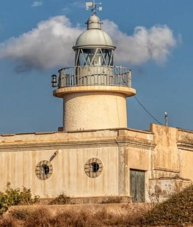
1865 (Leonardo Tejada). Active; focal plane 49 m (161 ft); white light, 2.5 s on, 1 s off. 8 m (26 ft) round cylindrical masonry tower with lantern and gallery, rising from a 1-story keeper's house. Lighthouse painted white; lantern dome is gray metallic. Andrés Otálora's 2022 photo is at right, Trabas has Meyer's 2021 photo, a 2022 photo and a 2023 closeup are available, Juan Ramón Martínez Inglés also has a fine photo, Klaus Schlitt has a street view, and Google has a satellite view. Located on a promontory about 3 km (2 mi) southeast of Portmán and 10 km (6 mi) east of Cartagena. Site open, tower closed. . ARLHS SPA-211; ES-23660; Admiralty E0134; NGA 4596.
Escombreras (Islote de Escombreras)
1864 (Antonio Molina). Active; focal plane 65 m (213 ft); white flash every 5 s. 8 m (26 ft) round cylindrical masonry tower rising from a 1-story keeper's house. Lighthouse painted white; lantern dome is gray metallic. Trabas has Capt. Peter's closeup 2021 photo, a 2011 photo is available, Huelse has a historic postcard closeup, and Google has a satellite view. The Islote de Escombreras is a small, steep-sided island off the eastern entrance to the bay of Cartagena. The island helps shelter the industrial harbor of Escombreras. A new breakwater hooks around the north side of the island, but does not connect to it. Located on the peak of the island. Accessible only by boat. Site and tower closed. . ARLHS SPA-167; ES-23190; Admiralty E0126; NGA 4564.

Portmán Light, Portmán, September 2022
Instagram photo
by Andrés Otálora
* Cartagena Dique de la Curra
1892. Active; focal plane 14 m (46 ft); three green flashes every 14 s. 11 m (36 ft) round concrete tower with lantern and castellated gallery. The lantern and upper third of the tower are painted green, the rest of the tower white. Trabas has Capt. Peter's 2021 closeup, another good photo is available, Alberto Rodriguez Aguilera has a 2022 drone view, and Google has a 2022 street view and a satellite view. This light stands at the end of the Dique de la Curra, the main breakwater, which projects from the east side of Cartagena harbor. Accessible by walking the breakwater. Site open, tower closed. ARLHS SPA-087; ES-23470; Admiralty E0130; NGA 4592.
* Navidad (Cartagena Dique de la Navidad) (2)
1892 (station established 1875). Active; focal plane 15 m (49 ft); two red flashes every 10 s. 11 m (36 ft) round concrete tower with lantern and gallery. The lantern and upper third of the tower are painted red, the rest of the tower white with red trim. A 2023 photo by Raúl Martínez is at right, Trabas has Capt. Peter's 2021 closeup, another closeup photo is available, Huelse has a historic postcard view, Víctor Caballero has a street view, and Google has a satellite view. This handsome little lighthouse is a familiar sight of Cartagena harbor. It stands at the end of the Dique de la Navidad, a breakwater mole projecting from the west side of the harbor entrance. A shipwreck museum, the Museo Nacional de Arqueología Subacuática, is at the base of the breakwater. Accessible by walking the breakwater. Site open, tower closed. ARLHS SPA-103; ES-23450; Admiralty E0128; NGA 4588.
* Podadera (2)
1866 (station established 1856). Inactive since the 1890s. Approx. 7.5 m (25 ft) round cylindrical stone tower attached to a 1-story stone keeper's house. The lighthouse is unpainted. Lantern and gallery removed. Alberto Rodriguez has a closeup 2018 photo, Santiago Serrano Egea has another closeup photo, Klaus Schlitt has a street view from a ruined 19th century fort below the lighthouse, and Google has a satellite view. Endangered. The building is sealed but abandoned and decorated with graffiti. The lighthouse was deactivated shortly after the Dique de la Curra and Navidad lighthouses were completed in 1892. Located on a promontory on the west side of the entrance to Cartagena harbor, above the fortifications of the Bateria de Podadera. Site open, tower closed. ARLHS SPA-349.
* Cabo Tiñoso
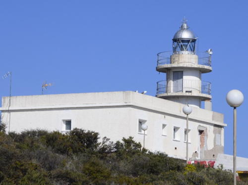
1859 (extensively rebuilt in 1970). Active; focal plane 146 m (479 ft); four white flashes, in a 1+3 pattern, every 20 s. 10 m (30 ft) robust round cylindrical masonry tower with lantern and double gallery attached to a 1-story keeper's house. Lighthouse painted white; lantern dome is gray metallic. Manuel Hernández Lafuente has a closeup photo, Trabas has a 2006 closeup, Alberto Rodriguez has a 2018 photo, and Google has a satellite view. The original lantern was removed and the tower was rebuilt in 1970, altering its historic appearance. The lighthouse has a range of 24 nautical miles (44.5 km, 27.5 mi), standing atop spectacular cliffs on a rugged promontory southwest of Cartagena. The surrounding waters are a marine reserve, the Cabo Tiñoso-La Azohía Reserva Marina. Located about 15 km (9 mi) west southwest of Cartagena, but at least three or four times that far by circuitous mountain roads. Site open, tower closed. ARLHS SPA-048; ES-23070; Admiralty E0124; NGA 4548.

Dique de la Navidad Light, Cartagena, July 2023
Instagram photo by Raúl Martínez

Bajo Guadalentín Lighthouse
* Mazarrón (2)
1974 (Carlos Mondéjar) (station established 1862). Active; focal plane 65 m (213 ft); white light occulting three times, in a 1+2 pattern, every 13.5 s. 11 m (36 ft) round cylindrical concrete tower with lantern and double gallery, painted white. The lighthouse is adjacent to a 1-story equipment building, also painted white. A 2018 photo by Joaquin Riquelme Añon is at right, Trabas has a 2012 photo, Joaquin Riquelme Añon has a 2018 photo, a photo of the light in action is available, and Google has a street view and a satellite view. Accessible by a short walk (the lighthouse drive is closed to cars). Located on a steep headland south of the harbor of Mazarrón. Site and tower closed but the lighthouse can be seen from nearby. ARLHS SPA-084; ES-23000; Admiralty E0120; NGA 4536.

Alto Guadalentín Lighthouses
Islote de la Aguilica
Date unknown. Active; focal plane 19 m (62 ft); green flash every 3 s. 10 m (33 ft) multistage square concrete tower painted white. Trabas has a closeup 2012 photo, Isaac Martinez has a street view, and Google has a satellite view. Located on a tiny island just of the east side of the entrance to the harbor of Águilas. Accessible only by boat. Site open, tower closed. ARLHS SPA-006; ES-22940; Admiralty E0117.5; NGA 4532.
* Águilas (Punta Negra) (2)
1973 (station established 1860). Active; focal plane 30 m (98 ft); two white flashes every 5 s. 23 m (75 ft) round cylindrical concrete tower with lantern and double gallery, painted with black and white horizontal bands. The lighthouse is adjacent to a 2-story square crew or administration building. Ricardo Codorniu has an excellent photo, Trabas has a 2012 photo, and Google has a 2023 street view and a satellite view. Huelse has a historic postcard view of the station in its original form. Located on Punta Negra, at the west entrance to the harbor of Águilas. Site open, tower closed. ARLHS SPA-246; ES-22900; Admiralty E0114; NGA 4524.

Mazarrón Light, Mazarrón, May 2018
Google Maps photo by Joaquin Riquelme Añon

Information available on lost lighthouses:

Notable faux lighthouses:

Adjoining pages: North: Valencian Community | West: Eastern Andalusia

Return to the Lighthouse Directory index | Ratings key

Posted February 20, 2006. Checked and revised July 27, 2025. Lighthouses: 13. Site copyright 2025 Russ Rowlett and the University of North Carolina at Chapel Hill.