Lighthouses of Spain: Eastern Andalusia

The Kingdom of Spain occupies nearly 85% of the Iberian Peninsula in southeastern Europe with coastlines facing south and southeast on the Mediterranean Sea and northwest on the Atlantic Ocean. Spain also includes the Balearic Islands in the Mediterranean, the Canary Islands in the Atlantic, and the cities of Ceuta and Melilla on the north coast of Morocco.

Since 1978 Spain has been divided into 17 regions called autonomous communities (comunidads autónoma) that have been granted varying degrees of autonomy by the central government. The autonomous communities are subdivided into provinces (provincias). The autonomous community of Andalucía (Andalusia in English) is in the southern part of the country, including the coastal provinces of Almería, Granada, Málaga, Cádiz, and Huelva. The western third of the coast faces southwest on the Atlantic, west of Gibraltar, while the eastern two thirds faces southeast on the Mediterranean. This page includes the lighthouses of the Mediterranean coast, east of Gibraltar; lighthouses of the Atlantic coast are described on the Western Andalusia page.

The westernmost extension of the Mediterranean Sea (from Cabo de Gata to Gibraltar) is also known as the Alboran Sea.

The word for a lighthouse is faro in Spanish but its use is generally restricted to the larger coastal light stations. Smaller lighthouses are called balizas (beacons). In Spanish isla is an island, cabo is a cape, punta is a promontory or point of land, péñon is a rock, arrecife is a reef, bahía is a bay, ría is an estuary or inlet, estrecho is a strait, río is a river, and puerto is a port or harbor.

The navigational lights in Spain are the responsibility of the national port authority, Puertos del Estado, but many of them are operated and maintained by regional port authorities. The Comisión de Faros, founded in 1842 to build and maintain Spanish lighthouses, is now an advisory panel.

ARLHS numbers are from the ARLHS World List of Lights. ES numbers are from the Spanish national list of lights, Libro de Faros. Admiralty numbers are from volume E of the Admiralty List of Lights & Fog Signals. U.S. NGA List numbers are from Publication 113.

General Sources
Libro de Faros y Señales de Niebla
Online edition of the official Spanish light list.
Asociación de Amigos de los Faros de Andalucía
This support group for Andalusian lighthouses has an interesting blog with many photos.
Online List of Lights - Spain East Coast
Photos by various photographers posted by Alexander Trabas.
Lighthouses in Spain
Excellent aerial photos posted by Marinas.com.
Phares d'Europe
Photos posted by Alain Guyomard and Robert Carceller.
Navigation and Ships - Lighthouses
Photos by Fran García.
Leuchttürme in Spanien am Mittelmeer
Photos posted by Bernd Claußen.
Lighthouses in Andalusia
Photos by various photographers available from Wikimedia.
World of Lighthouses - Spain
Photos by various photographers available from Lightphotos.net.
Spanische Leuchttürme auf historischen Postkarten
Historic postcard images posted by Klaus Huelse.
GPSNauticalCharts
Navigational chart information for Spain's Mediterranean coast.
Navionics Charts
Navigational chart information for Spain's Mediterranean coast.


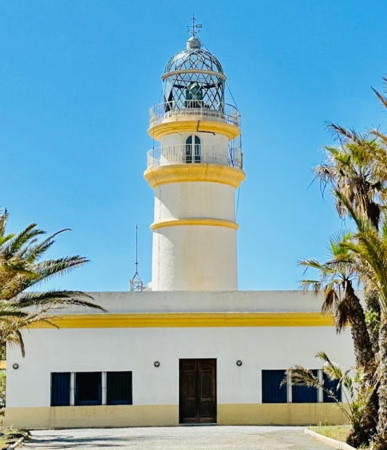
Cabo de Gata Light, Almería, November 2021
Google Maps photo by Manfred Riggers

Lighthouses of Almería

Lighthouses in Almería Province are operated and maintained by the Autoridad Portuaria de Almería.

Levante Almeriense (Eastern Almería) Lighthouses
** Garrucha
1881. Inactive since 2021. 10 m (33 ft) round cylindrical stone tower with lantern and gallery, attached to a square 1-story stone keeper's house. Building painted white; the lantern is gray metallic. Trabas has Eckhard Meyer's photo, Eduardo Sanz Mateo has a photo, Antonio Morales has a 2021 photo, and Google has a street view and a satellite view. Built to replace the 1863 Villaricos light, this harbor lighthouse remained in service until it was obscured by modern high-rise development. It was replaced by the new Mojácar light (next entry). The building houses the port captain's office. Located on the waterfront of Garrucha, near the south end of town. Site open, building probably open during business hours, tower status unknown. ARLHS SPA-078.
* Mojácar
2021. Active; focal plane about 152 m (500 ft); white light occulting four times every 13 s (?). 7.5 m (25 ft) round lantern atop a 1-story equipment building. Entire lighthouse is white. Antonio Morales has a closeup photo and Google has a satellite view. Located on a hill, the Cerro del Moro Manco, in Mojácar, about 2.5 km (1.5 mi) south southwest of the Garrucha lighthouse. Accessible by road. Site open, tower closed. . ES-22800; Admiralty E0110; NGA 4512.
* Mesa Roldán
1863 (Antonio Molina). Active; focal plane 222 m (728 ft); four white flashes every 20 s. 18 m (59 ft) octagonal tower with lantern and double gallery, attached to a 1-story keeper's house. 3rd order Fresnel lens in use. Buildings painted white with ocher trim; the lantern is painted gray metallic. A 2023 photo by Vicente Martinez is at right, Juan Antonio López López has a fine photo, Trabas has Eckhard Meyer's closeup photo, Carlos Olmo Bosco has a 2008 photo, a 2024 photo is available, and Google has a street view and a satellite view. The light at Punta de la Polacra is higher, but this historic lighthouse has a much greater range of 43 km (27 mi). Mesa Roldán is a long-extinct volcanic dome. Located at the summit of the dome about 8 km (5 mi) south of Carboneras. Accessible by a twisting mountain road (4WD recommended). Site open, tower closed. Site manager: Parque Natural de Cabo de Gata. ARLHS SPA-178; ES-22700; Admiralty E0108; NGA 4496.

Mesa Roldán Light, Carboneras, October 2023
Google Maps photo by Vicente Martinez

Almería Metropolitan Area Lighthouses
Almería, the provincial capital, is a city of about 200,000 residents. Surrounded by a predominantly agricultural area it has not been a major port in the past, but a modern container terminal is increasing its importance.

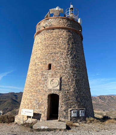
* Punta de la Polacra (La Polacra, Torre de los Lobos)
1991. Active; focal plane 281 m (922 ft); three white flashes every 14 s. 14 m (56 ft) round strongly conical stone watchtower, converted to a lighthouse by addition of a light on a short mast at the top. The tower is unpainted gray stone. A closeup 2023 photo by Ana Matusevic is at right, Trabas has Eckhard Meyer's photo, Carlos Olmo Bosco has a 2008 photo, a 2015 photo is available, Vicente Oliva de la Serna has a street view, and Bing has a satellite view. This watchtower is comparatively recent, having been built in 1767. It has become the highest lighthouse in Spain and is said to be the highest of the Mediterranean. Located atop a peak called Cerro de los Lobos, about 25 km (15 mi) northeast of Cabo de Gata. Accessible by a steep mountain road; parking available. Site status unknown. Site manager: Parque Natural de Cabo de Gata. ARLHS SPA-213; ES-22662; Admiralty E0107.7; NGA 4495.
* Cabo de Gata
1863 (Antonio Molina). Active; focal plane 55 m (180 ft); flash every 4 s, white or red depending on direction. 19 m (62 ft) round stone tower with lantern and double gallery, attached to a 1-story keeper's house. Buildings painted white with ocher trim; lantern is unpainted gray metallic. Fog horn (Morse code "G": two longs and one short, every 40 s). A 2021 photo by Manfred Riggers is at the top of this page, Wikimedia has a photo and Pablo Forcén Soler's distant view, Trabas has a closeup by Ian Wright, and Google has a street view and a satellite view. This historic and famous lighthouse marks the extreme southeastern corner of Spain, a location that has been the site of countless shipwrecks since the time of the Phoeniceans. The light station was built on the ruins of the 1737 Fuerte de San Francisco de Paula. During World War I German submarines sank so many ships off the cape that the British protested to Spain, believing that the lightkeepers must be tipping off the subs; an investigation proved they were not. The lighthouse was repaired after being damaged by an air raid during the Spanish Civil War in July 1937. The wild area surrounding the cape is now included in a national park. Located on the southernmost point of the cape. Accessible by road; parking provided. Site open, tower closed. Site manager: Parque Natural de Cabo de Gata. . ARLHS SPA-015; ES-22640; Admiralty E0106; NGA 4492.

La Polacra Light, Almería, Decembra 2023
Instagram photo by Ana Matusevic
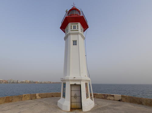
* Almería Dique de Poniente (Almería Breakwater) (3)
1925 (station established 1865). Active; focal plane 19 m (62 ft); red flash every 5 s. 12 m (39 ft) octagonal cylindrical tower with lantern and gallery. Lighthouse painted white, lantern and gallery red. An evening 2021 photo is at right, Trabas has a photo, Ginés Valera has a 2020 closeup photo, Carlos Moreno has a fine 2007 closeup, and Google has a satellite view and a very distant street view. The first lighthouse was made obsolete by extension of the breakwater; it was replaced with an unusual portable light (on a wheeled cart) in 1883. Located at the end of the breakwater, a long pier enclosing the harbor of Almería. Accessible by walking the breakwater. Site open, tower closed. . ARLHS SPA-116; ES-22430; Admiralty E0096; NGA 4464.
* Almería (Castillo de San Telmo)
1976. Active; focal plane 77 m (253 ft) two white flashes every 12 s. 7 m (23 ft) square cylindrical tower with lantern built atop a watchtower of the Castillo de San Telmo. Lighthouse painted white with a black vertical stripe on each of the two seaward faces. Trabas has a photo, Jose Gregorio Hernandez has a 2023 photo, Wikimedia has a distant view, Carmelo Rivas has a closeup street view, and Google has a street view and a satellite view. The castle was built in the late 18th century. Located on heights on the west side of Almería, above Castell del Rey. Accessible by a very long stairway from a service roundabout on the coastal highway, but parking is limited. Site open, tower closed. ARLHS SPA-064; ES-22360; Admiralty E0093; NGA 4452.

Twilight at the Dique de Poniente Light, Almería, February 2021
Google Maps photo by A R

Poniente Almeriense (Western Almería) Lighthouses
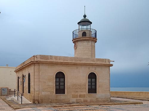
*** Roquetas de Mar
1863. Reactivated (inactive 1942-?, now unofficial but charted by Navionics); focal plane 17 m (56 ft); continuous white light. Approx. 12 m (39 ft) round cylindrical stone tower with lantern and gallery, attached to the front of a 1-story stone keeper's house. The buildings are unpainted; lantern painted white with a green dome. A photo is at right, Alberto Fernandez has a 2021 closeup photo, a good 2018 closeup photo and a nighttime photo of the light in action are available, and Google has a street view and a satellite view. The lighthouse was abandoned because of changes to the harbor and because it was too short to show up well against the lights of the town. It was replaced by lights on the breakwaters. Recently the lighthouse has been restored and transferred to the city; it is in use as a gallery for art and photography exhibits. Located on the waterfront on the south side of the harbor of Roquetas de Mar. Site open, building open daily, tower status unknown. Owner/site manager: Ayuntamiento de Roquetas de Mar. ARLHS SPA-298.
* Sabinal (Punta Sabinar) (3)
1926 (station established 1863). Active; focal plane 34 m (112 ft) three white flashes, in a 1+2 pattern, every 10 s. 32 m (105 ft) round masonry tower with lantern and double gallery, attached to a 1-story keeper's house. Lighthouse painted white with ocher trim. Trabas has a photo, Carlos Olmo Bosco has a 2008 photo, Jorge Fuentes has a 2018 photo, a fine 2021 photo is available, and Google has a good satellite view and a very distant street view. The first lighthouse, a 9 m (30 ft) tower built only 50 m (55 ft) from the sea, collapsed in the surf in 1915 and was replaced immediately by a temporary wooden tower. The new lighthouse was set back 400 m (1/4 mi) from the beach to save it from continuing erosion. Fighting during the Spanish Civil War heavily damaged the present lighthouse and destroyed its Fresnel lens in June 1937. Located in El Sabinal, an area of dunes and wetlands south of San Agustín, at the western entrance to the Golfo de Almería. The entrance road is unmarked. Site open, tower closed. Site manager: Reserva Natural Punta Entinas-Sabinar. ARLHS SPA-258; ES-22250; Admiralty E0090; NGA 4440.

Roquetas de Mar Light, Roquetas de Mar, April 2022
Wikimedia Creative Commons photo by CarlosVdeHabsburgo
* Punta de los Baños
1992. Active; focal plane 22 m (72 ft); four white flashes every 11 s. Approx. 18 m (59 ft) square cylindrical concrete tower with the light displayed from a "shelf" projecting from the top of the tower. Trabas has a photo, Raul Ruiz Alvarez has a closeup, Francisco Garcia also has a photo, and Google has a satellite view. This unusual modern lighthouse was designed by the architect Rafael Melida Poch. Located just off the beach on a point of land at Guardias Viejas. Site open, tower closed. ARLHS SPA-291; ES-22140; Admiralty E0089.5; NGA 4430.
* Adra (2)
1899 (station established 1883). Inactive since 1986. 6 m (20 ft) round cylindrical stone tower attached to one corner of a 1-story stone keeper's house. Lantern removed. The buildings are unpainted. Jose Espinosa Carpintero has a 2019 photo and Google has a street view and a satellite view. The first Adra light, a 13 m (43 ft) hexagonal wooden tower, was built near the former mouth of the Río Adra; it was quickly threatened by erosion and collapsed during a storm in 1896. The light was then moved to a safer location about 3 km (2 mi) to the west. The lighthouse was repaired after being damaged during the Spanish Civil War in the 1930s. The building is now a station of the local police (Protección Civil). Site open, building closed. ARLHS SPA-334.
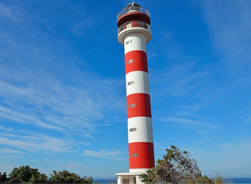
* Adra (3)
1986. Active; focal plane 49 m (161 ft); three white flashes every 10.5 s. 26 m (85 ft) round cylindrical concrete tower with lantern and double gallery. Lighthouse painted with red and white horizontal bands. A photo is at right, Trabas has Eckhard Meyer's photo, Marcela Freire has a 2023 photo, Carlos Olmo Bosco has a 2008 photo, and Google has a street view and a satellite view. Located just off the old coastal road (highway N-340A) on the west side of Adra. Site open, tower closed. . ARLHS SPA-068; ES-22050; Admiralty E0088; NGA 4424.

New Adra Light, Adra, September 2009
Flickr Creative Commons photo by dePoniente GDP Almería Occ.

Isla de Alborán Lighthouse
Isla de Alborán
1876. Active; focal plane 40 m (131 ft); four white flashes every 20 s. 20 m (66 ft) round cylindrical stone tower with gallery and a small lantern, rising from the center of a 2-story keeper's house. Tower unpainted; watch room painted white, lantern red; house is buff with unpainted red-brown stone trim. A 2017 aerial photo is available, Carlos Saavedra Aubert has a 2019 view from the sea, Degree Confluence Project also has a photo showing the view from the sea, and Google has a satellite view of the station. Alborán is a small, barren island 56 km (35 mi) north of the Cap des Trois Fourches, Morocco, and 90 km (56 mi) south of the Spanish mainland at Adra. The island was captured by Spain in 1540 from the Tunisian captain Al Borani, for whom it was named. Alborán had always been uninhabited except for the lighthouse keepers. However, after Soviet fishing vessels landed on the island in 1960 the Spanish navy established a base there occupied by rotating crews. In 1997 the island was incorporated into a marine reserve along with the surrounding waters. In 2003-04 the lighthouse was restored and converted to wind power; the original lantern was removed and replaced by the present small lantern. Accessible only by boat. Site and tower closed. Operator: Autoridad Portuaria de Málaga. Site manager: Armada Española. ARLHS CEU-009; ES-22120; Admiralty E0086; NGA 22780.

Lighthouses of Granada

Mostly an inland province, the province of Granada has a relatively short coastline with no major ports. Its former port authority, the Autoridad Portuaria de Motril, has been merged into the Autoridad Portuaria de Almería, so it is that authority that now operates these lighthouses.

Costa Tropical Lighthouses
Punta del Melonar (Castell de Ferro, Torre de la Instancia)
1992. Active; focal plane 237 m (776 ft); three white flashes every 13 s. 12 m (39 ft) round strongly conical stone watchtower, converted to a lighthouse by addition of a lantern on a short cylindrical tower on the roof. Access to the light is by a bridge from a square service building adjacent to the lighthouse. Trabas has Eckhard Meyer's photo, Carlos Olmo Bosco has a good 2008 photo, Juan de Dios Rodriguez Cáceres has a 2023 photo, and Google has a satellite view. This, Spain's second highest light, is another historic watchtower renovated into a lighthouse. Located atop a sharp peak above the coast on the southwest side of Castell de Ferro; it is not clear if there is public access to this site. ARLHS SPA-060; ES-22020; Admiralty E0082; NGA 4422.
* Cabo Sacratif
1863 (Constantino Germán). Active; focal plane 98 m (322 ft); two white flashes every 10 s. 17 m (56 ft) round masonry tower with lantern and gallery, rising from a 1-story keeper's house. Lighthouse painted white with gold trim; lantern is all glass, even the dome. A 2023 photo is at right, Trabas has a good photo by Hans-Albert Liebetrau, Salvador Rodriguez Caña has a closeup photo, Claußen has photos, a 2017 photo is available, and Google has a street view and a satellite view. This lighthouse marks the southernmost point of the Granada coastline. Located just off the coastal highway E-15 on a high promontory, the Cerro del Chucho, about 9 km (5.5 mi) southeast of Motril. Only a small sign marks the entrance. Site open, tower closed. . ARLHS SPA-042; ES-22000; Admiralty E0080; NGA 4420.
* Punta de la Mona (La Herradura, Torre de los Berengueles)
1992. Active; focal plane 140 m (459 ft); white flash every 5 s. 14 m (46 ft) round strongly conical rubblestone watchtower, converted to a lighthouse by addition of a lantern on a short cylindrical tower on the roof. Access to the light is by an external stairway that winds around the tower. Thanks to Greg Beal for contributing a closeup photo; Trabas has Eckhard Meyer's photo, a 2016 photo is available, Pako Sánchez has a closeup street view, and Google has a satellite view. This is one of the many historic watchtowers on Spain's south coast that have been converted in recent years to serve as lighthouses. In this case the tower is the Torre de los Berengueles, which dates from the 18th century, replacing a medieval tower at the same location. An unsightly cellphone tower stands beside the lighthouse, but visitors can enjoy the spectacular view of the Mediterranean from an overlook at the base of the tower. An upscale residential area surrounds the tower; a good map or some local guidance will be needed to find your way to the top. Located on a high, rocky promontory at Punta de la Mona, between the popular beaches of La Herradura and Almuñécar. Site open, tower closed but visitors can climb the spiral stairway. . ARLHS SPA-289; ES-21890; Admiralty E0074.8; NGA 4411.

Cabo Sacratif Light, Motril, May 2023
Google Maps photo by Gonzalo Gonzalez

Lighthouses of Málaga

The province of Málaga includes the famous resort area known as the Costa del Sol, its beaches backed by high mountains and facing south on the Mediterranean. Lighthouses in the province are operated and maintained by the Autoridad Portuaria de Málaga.

Axarquía Lighthouses
** Punta de Torrox
1864. Active; focal plane 29 m (95 ft); four white flashes every 15 s. 23 m (75 ft) round cut stone tower with lantern and double gallery, surrounded by a 1-story keeper's house. The lighthouse, painted entirely white, rises from the central courtyard of the circular house. Trabas has an excellent photo by Hans-Albert Liebetrau, Wikimedia has photos, another photo is available, and Google has a street view and a fine satellite view. The tower was heightened and the second gallery added in 1922. In 2019 the light station was transferred to control of the city, which operates a museum with Roman artifacts discovered in excavations begun by an early lighthouse keeper. Located on a promontory above the beach at Torrox-Costa, 4 km (2.5 mi) south of Torrox. Site and museum open, tower closed. Site manager: Faro de Torrox . ARLHS SPA-219; ES-21880; Admiralty E0074; NGA 4408.
* Torre del Mar (3)
1930 (station established 1864). Inactive since 1969. 10 m (33 ft) square cylindrical rubblestone tower with lantern and gallery. J.M. López has a 2022 photo and Google has a 2018 street view and a satellite view. The original lighthouse, built at the mouth of the Río Vélez, collapsed in 1880 due to beach erosion both by the ocean and the river. It was replaced by a "temporary" wood tower, which served until this tower was finally built in 1930. By the late 1960s rapid beachfront development had rendered this lighthouse useless and today it is surrounded by high-rise buildings. The lighthouse was restored in 2017. Located off the Avenida Antonio Toré Toré at the Calle Barracas Pte., two blocks north of the modern lighthouse. Site open, tower closed.
* Torre del Mar (4)
1969 (station established 1864). Inactive since 1974; a decorative white light is displayed. 10 m (33 ft) square cylindrical rubblestone tower with lantern and gallery. A photo is at right, Teresa Marcos has a 2023 photo, and Google has a 2018 street view and a satellite view. When the 1930 lighthouse became useless in the late 1960s, the local government built this copy of it on the beachfront. It had no lantern, however, and a 2008 photo shows the tower without a lantern. National authorities got to work designing a modern lighthouse, but construction did not begin until 1974. The lighthouse served until the current light was activated in June 1976. In 2018 the lighthouse was restored and a replica lantern identical to the lantern of the 1930 lighthouse was installed. Located beside the modern lighthouse. Site open, tower closed.
* Torre del Mar (5)
1976 (station established 1864). Active; focal plane 30 m (98 ft); three white flashes, in a 1+2 pattern, every 10 s. 28 m (92 ft) round cylindrical concrete tower with lantern and double gallery. Lighthouse painted with blue and white horizontal bands; lantern dome is gray metallic. A photo is at right, Trabas has Eckhard Meyer's photo, and Google has a 2014 street view and a satellite view. In 2013 the lighthouse, formerly all white, was repainted in the blue and white colors of the flag of Málaga province, and in 2016 a €50,000 project restored the interior and exterior of the tower. Located in a plaza at the foot of the Avenida de Antonio Toré Toré on the waterfront of Torre del Mar, about 32 km (20 mi) east of Málaga and about 1.8 km (1.1 mi) east of the Río Vélez; Site open, tower closed. . ARLHS SPA-277; ES-21780; Admiralty E0072; NGA 4392.

Old and new Torre del Mar Lights, Torre del Mar, April 2020
Instagram photo by amazingshots_lighthouse

Málaga City Lighthouses
With a metropolitan population of at least 1.6 million, Málaga is the major metropolis of the Costa del Sol as well as the provincial capital and a major port.
* Málaga ("La Farola")
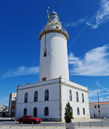
1817 (Joaquín M. Pery y Guzmán). Active; focal plane 38 m (125 ft); four white flashes, in a 3+1 pattern, every 20 s. 37 m (121 ft) robust round masonry tower with lantern and gallery, rising through the center of a 2-story keeper's house. 3rd order Chance Brothers Fresnel lens (1922). Entire lighthouse painted white. is at right, Ilja Survilo's 2021 photo is at right, Wikimedia has a good 2019 photo, Franz van Pelt has a 2011 photo, Trabas has a good photo, Huelse has a historic postcard view, and Google has a street view and a satellite view. One of the oldest and most historic lighthouses of Spain, this tower has lived an eventful life. The lighthouse was damaged by an earthquake in 1898 and not completely repaired until 1913. It was further damaged by artillery during the Spanish Civil War of the 1930s; it had to be extensively repaired and refurbished in 1939. In recent years GPS and radar installations have been added. It is known affectionately as La Farola, a term usually used for much smaller light towers. Floodlit at night, it is a familiar symbol of the city's waterfront. In 2023 plans were announced to develop the lighthouse as a museum; €72,600 was allocated to draw up plans for a restoration estimated to cost at least €600,000. Located on the Paseo de la Farola on the east side of the harbor of Málaga. Site open, tower closed. . ARLHS SPA-302; ES-21550; Admiralty E0062; NGA 4360.
Málaga Dique del Este (Málaga East Breakwater)
Date unknown. Inactive. Approx. 7 m (23 ft) slender round masonry tower atop a 1-story masonry equipment room. Entire lighthouse is white. Trabas has Rainer Arndt's photo and Google has a satellite view. ARLHS listed this light as "Malaga Head." This light was located at the end of the original west breakwater of Málaga; the harbor has since been extended considerably to the south and the light is on the quay where cruise ships dock. Site status unknown but the light can be seen from nearby and from arriving ships. ARLHS SPA-310; ex-ES-21570; ex-Admiralty E0064; NGA 4364.
#Málaga Dique de Poniente Extremo (Málaga West Breakwater) (1)
Date unknown. Removed. This was a 7 m (23 ft) slender round masonry tower atop a 1-story masonry equipment room. Entire lighthouse was white.The light has been removed and the breakwater shortened to clear the way for cruise ships docking nearby. Google has a satellite view of the former location. The active light (two red flashes every 7 s) is on a short tripod at the end of the truncated breakwater. Located at the end of the old west breakwater of Málaga (the harbor has since been extended and there is another breakwater to the south). Site status unknown. ARLHS SPA-303. Active light: ES-21590; Admiralty E0066; NGA 4368.

Málaga Light, Málaga, September 2021
Google Maps photo by Ilja Survilo

Costa del Sol Occidental Lighthouses
* Calaburras (2)
1928 (station established 1863). Active; focal plane 46 m (151 ft); white flash every 5 s. 25 m (82 ft) round cut stone tower with lantern and gallery, rising from a circular equipment building. The tower is unpainted white stone. Trabas has a photo, Claußen has photos, Wikimedia has many photos, Carlos Zalazar has a 2022 drone view, and Google has a street view and a satellite view. This lighthouse marks a major cape where the trend of the coastline changes from east to north northeast. The location is quite conspicuous; part of the light station property was taken in 1999 in order to widen the A-7 coastal highway (the Autovia del Mediterráneo), which now runs very close to the lighthouse. The present lighthouse replaced a 13.5 m (45 ft) octagonal masonry tower. The lighthouse was formerly attached by a covered passageway to the original (1863) 1-story masonry keeper's house, as shown by a historic photo (bottom of the page). Located on the Punta das Calaburras about 4 km (2.5 mi) south of Fuengirola. Site open, tower closed. . ARLHS SPA-198; ES-21280; Admiralty E0058; NGA 4320.
* Marbella (2)
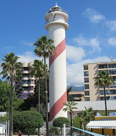
1974 (station established 1864). Active; focal plane 35 m (115 ft); two whaite flashes every 14.5 s. 29 m (95 ft) round cylindrical concrete tower with lantern and double gallery. 3rd order Barbier, Bernard & Turenne Fresnel lens in use. Lighthouse painted white with a single red spiral stripe added sometime in 2014-15. The 2019 photo at right shows the spiral stripe, Shokry Mahsob has a 2021 photo, Wikimedia several photos, Trabas has an older (pre-stripe) photo, and Google has a 2012 street view and a satellite view. In early 2016 the port authority was asking developers to submit proposals to renovate the lighthouse as a tourist attraction. Nothing happened immediately, but in 2024 the town was acting to improve public access and develop a park and gardens around the lighthouse. Huelse has a postcard view of the original lighthouse and a historic view of it is available. Located just off the beach in Marbella, a resort city of about 150,000 residents. Site open, tower closed. . ARLHS SPA-083; ES-21100; Admiralty E0056; NGA 4304.
* Puerto José Banús
Date unknown. Active; focal plane 13 m (43 ft); three green flashes every 12 s. 9 m (30 ft) round unpainted rubblestone tower rising from a round 1-story base. Trabas has a photo, Marcin Banasik has a 2022 photo, and Google has a satellite view. Puerto Banús, named for its developer, is an upscale shopping, entertainment and marina development located about 6 km (4 mi) southwest of downtown Marbella. Located at the end of the south (main) breakwater of the marina. Accessible by walking the pier. Site open, tower closed. ES-21060; Admiralty E0032; NGA 4296.

Marbella Light, Marbella, May 2019
Google Maps photo by Mister No
* Punta de la Doncella (Estepona) (2)
1922 (station established 1863). Active; focal plane 31 m (102 ft); three white flashes in a 1+2 pattern every 15 s. 21 m (69 ft) octagonal stone tower with lantern and gallery, attached to a 1-story masonry keeper's house. Original 3rd order Barbier, Bernard & Turenne Fresnel lens in use. The tower is unpainted and the lantern is all glass, including the dome. Peter Bauer's 2021 photo is at right, Trabas has a fine photo, a 2008 photo is available, Wikimedia has photos, and Google has a street view and a satellite view. The original lighthouse, seen in Huelse's postcard view, was only 8.5 m (28 ft) tall. The keeper's house is the 1863 original, although it has been modified over the years. Located on the Avenida del Puerto just off the Avenida de España, the seaside boulevard, in the resort town of Estepona. Site open, tower closed. . ARLHS SPA-212; ES-20940; Admiralty E0020; NGA 4280.

Lighthouses of Eastern Cádiz

Campo de Gibraltar Lighthouse
* Punta Carbonera (Punta Mala)
1990 (Enrique Martínez Tercero). Active; focal plane 39 m (128 ft); white light occulting once every 4 s. 14 m (46 ft) round stucco-covered rubblestone tower with an aluminum lantern mounted off-center. Lighthouse painted a pale yellow. Trabas has a closeup photo, Vicente Fernandez has a 2018 closeup, Alfredo Nieto Franco has a 2021 photo, and Google has a satellite view. This is another historic watchtower converted into a lighthouse. Located on a bluff facing the Mediterranean about 15 km (9 mi) north of La Linea. Some local guidance may be needed to find this location. Site open, tower closed. ARLHS SPA-082; ES-20820; Admiralty E0012; NGA 4266.
 

Punta de la Doncella Light, Estepona, February 2021
Google Maps photo by Peter Bauer
 

Information available on lost lighthouses:

Notable faux lighthouses:

Adjoining pages: East: Murcia and Valencia | Southwest: Gibraltar | West: Western Andalusia

Return to the Lighthouse Directory index | Ratings key

Posted February 1, 2006. Checked and revised June 18, 2024. Lighthouses: 28. Site copyright 2024 Russ Rowlett and the University of North Carolina at Chapel Hill.