Lighthouses of Finland: Ostrobothnia

The Republic of Finland (Suomi in Finnish) is a country of northern Europe with coastlines facing south on the Gulf of Finland (Suomenlahti) and west on the Gulf of Bothnia (Pohjanlahti), both arms of the Baltic Sea. Finland also administers the Åland Islands (Ahvenanmaa), an archipelago at the junction of the two gulfs. After centuries of rule by Sweden, Finland was conquered by Russia in 1809 and became an autonomous grand duchy within the Russian Empire. The country declared its independence from Russia at the start of the Russian Revolution in 1917. It lost some of its eastern territory to Russia as a result of World War II but has retained its independence.

Finland is divided into nineteen regions (maakunta) and the regions are divided into municipalities. This page includes the lighthouses of the Gulf of Bothnia in the regions of Ostrobothnia and Central Ostrobothnia. These regions include the central west coast of the country. Lighthouses of the Northern Ostrobothnia Region are described on the Northern Ostrobothnia page.

The Finnish word for a lighthouse is majakka (plural majakat). Saari is an island, luoto is an islet or skerry, niemi is a cape or headland, niemimaa is a peninsula, lahti is a bay, salmi is a strait, joki is a river, and satama is a port or harbor.

Swedish is a second official language in Finland and is more common than Finnish in many places in Ostrobothnia. On this page the names of Ostrobothnia municipalities are stated in Swedish with the Finnish equivalent in parentheses. Many of the lighthouses are commonly known by their Swedish names. In Central Ostrobothnia, by contrast, Finnish predominates.

Lighthouses in Finland are maintained by the Waterways Section of the Finnish Transport Agency (Liikennevirasto).

ARLHS numbers are from the ARLHS World List of Lights. SU numbers are from the official Finnish light list. Admiralty numbers are from volume C of the Admiralty List of Lights & Fog Signals. U.S. NGA List numbers are from Publication 116.

General Sources
Online List of Lights - Finland
Photos by various photographers posted by Alexander Trabas.
Finskt fyrväsende
Photos and information posted by the Swedish Lighthouse Society.
Finnish Lighthouses
Excellent photos of the some of the better known lighthouses, taken by Mikko Rauhala.
Lighthouses in Finland
Photos by various photographers available from Wikimedia.
World of Lighthouses - Finland
Photos by various photographers available from Lightphotos.net.
Galleria Majakat
Photos posted by Kimmo Koivunen.
Lighthouses in Finland
Aerial photos posted by Marinas.com.
Weitere Europäische Leuchttürme auf historischen Postkarten
Historic postcard images posted by Klaus Huelse.
List of Lights
The Finnish light list is available for download.
Finnish Lighthouse Society
The national lighthouse preservation association.
GPSNauticalCharts
Navigational chart information for southwestern Finland.
Navionics Charts
Navigational chart for southwestern Finland.
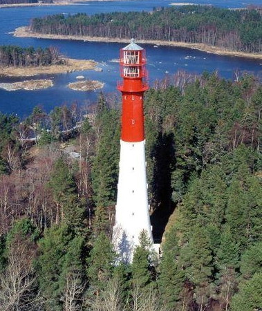
Yttergrund Light
Yttergrund Light, Fladen
Finnish Maritime Administration photo
Ostrobothnia (Pohjanmaa) Region Lighthouses

"Ostrobothnia" is the English version of the Swedish name Österbotten (East Bothnia); the Finnish name for the region is Pohjanmaa. Ostrobothnia faces the region of the Gulf of Bothnia known in Finnish as Merenkurkku ("sea throat") and in Swedish as Norra Kvarken ("north throat") because it is a narrow section connecting two wider sections, the Bothnian Sea (Selkämeri or Bottenhavet) to the south and the Bothnian Bay (Perämeri or Bottenviken) to the north.

Kristinestad (Kristiinankaupunki) Lighthouses
Kristinestad is a historic town, founded by Swedes in 1649. It has a population of about 6400.
** Yttergrund
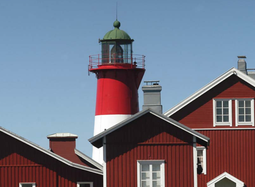
1892. Active; focal plane 44 m (144 ft); three long (2.5 s) white flashes every 30 s. 41 m (134 ft) round tapered cast iron tower with lantern and triple gallery. The lantern and upper third of the tower are painted red, the lower 2/3 white. 1-story wood keeper's house and other buildings. A photo is above, the Swedish Lighthouse Society has a page for the lighthouse, Rauli Rautavuori has a closeup photo, Trabas has a photo, Marinas.com has aerial photos, and Google has a satellite view. This historic tower, Finland's second tallest lighthouse, was prefabricated by the Helsinki firm of Kone & Siltarakennus. The lighthouse was restored for its 100th anniversary in 1992. Located on the island of Södra Yttergrund, at the south side of the entrance to Fladen. Accessible only by boat. Site open, tower usually closed but several open house dates are offered during the summer. . ARLHS FIN-077; SU-7435; Admiralty C4348; NGA 17616.
Kristiina (Kristinestad, Kristiinkaupunki)
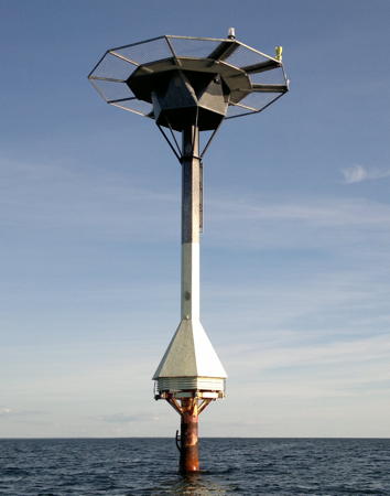
1991. Active; focal plane 23 m (75 ft); two white flashes every 20 s. 24 m (79 ft) steel and concrete post light with a conical equipment shelter near the bottom and a helipad on top. Upper half of the tower painted black, lower half white. A photo is at right and the Swedish Lighthouse Society has a page for the lighthouse, but the lighthouse is not shown in Google's satellite view. Located on a shoal about 12 km (7.5 mi) southwest of Kristinestad, a predominantly Swedish-speaking port also known by its Finnish name Kristiina. Accessible only by boat. Site open, tower closed. ARLHS FIN-023; SU-20637; Admiralty C4328.2; NGA 17663.
Härkmeri (Kristinestad) Range Front
Date unknown. Active; focal plane 17 m (56 ft); quick-flashing white light. Octagonal lantern, painted white, shining its light through a large rectangular daymark colored red with a yellow vertical stripe. Trabas has a distant view and Google has a satellite view. This is an outer approach range for Kristinestad. Located on the island of Torngrund, about 6 km (3.5 mi) south southwest of Kristinestad. Accessible only by boat. Site status unknown. ARLHS FIN-101; SU-7472; Admiralty C4330; NGA 17648.
Härkmeri (Kristinestad) Range Rear
Date unknown. Active; focal plane 24 m (79 ft); white light, 2 s on, 4 s off. Approx. 21 m (69 ft) rectangular cylindrical unpainted concrete tower; the seaward face carries a red rectangular daymark with a yellow vertical stripe on the range line. Trabas has a photo and the lighthouse is seen in Google's satellite view and distant street view. Located on the Hansnäs promontory about 5 km (3 mi) south of Kristinestad. Site status unknown. ARLHS FIN-128; SU-7286; Admiralty C4330.1; NGA 17652.

Kristiina Light, Gulf of Bothnia, August 2011
Wikimedia public domain photo by Herwood
Björnö (Båtskär) Range Rear
Date unknown. Active; focal plane 33 m (108 ft); white light, 2 s on, 4 s off. Approx. 25 m (82 ft) triangular cylindrical skeletal tower carrying a red rectangular daymark with a yellow vertical stripe. Trabas has a photo and Google has an indistinct satellite view. The front light is on a large daymark panel. This is an approach range for Björnö, an industrial harbor southwest of Kristinestad. Located on the south side of Björnö. Site status unknown. SU-7430; Admiralty C4328.1; NGA 17684.
Alesund Range Rear
Date unknown. Active; focal plane 21 m (69 ft); white light, 2 s on, 4 s off. Approx. 19 m (62 ft) triangular cylindrical skeletal tower carrying a yellow rectangular daymark with a red vertical stripe. Trabas has a photo and Bing has an indistinct satellite view. The front light is on a large daymark panel. Located on the watrfront on the north side of Kristinestad. Site status unknown. SU-7431; Admiralty C4329.1.
Gåsberget
Date unknown. Inactive. 5 m (17 ft) octagonal lantern, painted white, on a concrete base. No photo available but Google has a satellite view. Located at the south end of Gåsgrund, an island about 2.5 km (1.5 mi) offshore west of Kristinestad. Accessible only by boat. Site open, tower closed. ex-Admiralty C4326; ex-NGA 17704.

Kaskinen (Kaskö) Lighthouses
Kaskinen is a majority-Finnish speaking town with a population of about 1300.

Storremmargrund
Date unknown. Inactive as a light since 2015 but still listed by NGA as having a radar beacon (racon). 7 m (23 ft) round concrete tower with lantern and gallery, painted white one red horizontal band. The lighthouse is seen at the right of Trabas's photo of C4321 and Google has a satellite view. Located on a rocky reef in the entrance to the harbor of Kaskinen, roughly 500 m (1/4 mi) east southeast of the Sälgrund lighthouse. Accessible only by boat. Site open, tower closed. ex-Admiralty C4321.5; NGA 17720.
** Sälgrund (Kaskö)
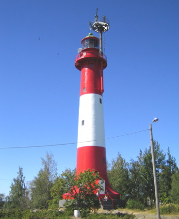
1875. Active; focal plane 30 m (98 ft); one very long (3.2 s) white flash every 30 s. 25 m (82 ft) round stone tower with lantern and gallery, painted with red and white horizontal bands. Pekka Järvenpää's photo is at right, the Swedish Lighthouse Society has a page for the lighthouse, another good photo, a 2010 photo and an aerial photo are available, Trabas has a view of the lantern, Marinas.com has aerial photos, Huelse has a historic (ca. 1902) postcard view, Mattias Nilsson has a street view, and Google has a satellite view. Adjacent to the light station is the former pilot station for Kaskinen, deactivated in 1986. The town has restored the pilot station buildings with a meeting space and overnight accommodations. Located at the southwestern tip of the island of Sälgrund, about 4 km (2.5 mi) southwest of Kaskinen. Passenger ferry service is available in the summer from Kaskinen. Site open, tower closed. Site manager: Kaskinen Seacharter. . ARLHS FIN-051; SU-7460; Admiralty C4318; NGA 17708.

Sälgrund Light, Kaskinen, July 2018
Google Maps photo by Pekka Järvenpää

Närpes (Närpiö) Lighthouses
Märigrund
Date unknown. Active; focal plane 11 m (36 ft); flash every 2 s, white, red or green depending on direction. 5.5 m (18 ft) square wood tower painted red. Trabas has a photo and Google has a satellite view. Located on a small island off the south end of Grytskär in the Närpes municipality. Accessible only by boat. Site open, tower closed. SU-7264; Admiralty C4314.
Gåshallan
Date unknown. Active; focal plane 12 m (39 ft); flash every 3 s, white, red or green depending on direction. 7.5 m (18 ft) square skeletal tower carrying a daymark colored white with a red vertical stripe. A photo is available and Bing has a satellite view. This island is the location of a well known nature station. Located on a small island off the north end of Grytskär in the Närpes municipality. Accessible only by boat. Site open, tower closed. Site manager: Naturstation Gåshällan. SU-7261; Admiralty C4312; NGA 17768.

Korsnäs Lighthouses
Lillgrund (2?)
Date unknown. Active; focal plane 13 m (43 ft); white flash every 3 s. Approx. 11 m (36 ft) triangular skeletal tower. Sven Westergård has a 2018 photo, Trabas has a distant view and Bing has a satellite view. NGA lists a "red round tower" for this light. Located on a small island about 1.2 km (3/4 mi) off the southwest coast of Halsön. Accessible only by boat. Site open, tower closed. Admiralty C4300; NGA 17800.
Svettgrund
Date unknown. Active; focal plane 11 m (36 ft); flash every 3 s, white, red or green depending on direction. Approx. 12.5 m (41 ft) square pyramidal skeletal daybeacon carrying a large, diamond-shaped wood daymark painted deep red. The light is mounted about halfway up one of the legs of the structure. Mapio.net has a closeup photo and Google has a satellite view. Located on a skerry about 2 km (1.25 mi) off the northwest coast of Halsön. Accessible only by boat. Site open, tower closed. SU-7251; Admiralty C4302; NGA 17804.

Malax (Maalahti) Lighthouses

Strömmingsbåden (Kallan)
1885. Active; focal plane 16 m (52 ft); four long (2 s) flashes every 20 s, white or red depending on direction. 14 m (46 ft) round stone tower with lantern and gallery. Lantern and top of the tower painted red, lower part of the tower white. 3rd order Fresnel lens in use. 1-story wood keeper's house, painted red. Johannes Tervo has a 2014 photo (also seen at right), Tero Koski has a closeup and a view of the station, an aerial photo is available, and Google has a satellite view. Ferries crossing the gulf between Vaasa and Sundsvall, Sweden, probably pass close to this remote lighthouse. Located on the small island of Norra Kallan, about 45 km (28 mi) west southwest of Vaasa. Accessible only by boat. Site status unknown. . ARLHS FIN-059; SU-7243; Admiralty C4294; NGA 17820.
[Rönnskärs Bak]
1784. Daybeacon, never lit. Approx. 20 m (66 ft) square 2-stage wood tower painted red and with a black pyramidal roof. Thea Nyman has a closeup photo and a view of the station, Mattias Nilsson has a street view, and Google has a satellite view. The beacon is part of a pilot station founded in 1752 and active until 1983. Located on the east side of the island of Rönnskär. Accessible only by boat. Site open, tower closed.

Strömmingsbåden Light, Norra Kvarken, February 2014
Google Maps photo by Johannes Tervo

 
Veckargrund (Väckergrund)
Date unknown. Active; focal plane 7 m (23 ft); flash every 3 s, white, red or green depending on direction. 6 m (20 ft) square concrete tower with lantern and gallery. Lighthouse painted white. No closeup photo available. The aerial photos of Marinas.com show a rectangular daymark panel, painted red with a yellow vertical stripe, standing about 14 m (46 ft) from the tower. Google has a satellite view. Located on a skerry about 35 km (22 mi) west of Vaasa. Accessible only by boat; there is probably a view from ferries sailing across the gulf between Vaasa and Sundsvall, Sweden. Site status unknown. SU-7476; Admiralty C4259; NGA 17964.

Korsholm (Mustasaari) and Vaasa City Lighthouses
Vaasa is a city of about 70,000 residents, the capital of the Ostrobothnia Region. The approach channel to the port of Vaasa is from the northwest; it begins south of the Utgrynnan lighthouse and leads ships around the south side of the large island of Replot.

Edvard Range Front
Date unknown. Active; focal plane 4 m (13 ft); quick-flashing white light. 5 m (16 ft) octagonal white lantern mounted on a white concrete base. Trabas has a photo by Capt. Theo Hinrichs and Google has a satellite view. The range guides vessels southward within Vaasa harbor. Located on the Söderbogrundet peninsula across from the Vaasa waterfront. Site status unknown. SU-7220; Admiralty C4280; NGA 18052.
Nikolai (Edvard Range Rear)
Date unknown. Active; focal plane 7 m (23 ft); white light, 2 s on, 4 s off. 13 m (43 ft) octagonal white lantern mounted on a short stone tower and topped by a mast carrying a round white daymark. Trabas has a photo by Capt. Theo Hinrichs and Google has a satellite view. Located onshore 366 m (400 yd) south of the front light. Site status unknown. SU-7442; Admiralty C4280.1; NGA 18056.
** Lightship Kalbådagrund (Ärensgrund)
1891. Decommissioned 1953. 29 m (95 ft) iron lightship, painted black with white trim. The former light tower has been removed, and the ship is rigged with a foremast and mainmast and a cabin at the stern. Michael Frank has a 2017 photo, a black-and-white 2011 photo is available, Google has a 2019 street view and a satellite view. This ship served until 1931 on the Ärensgrund station, and then another two decades at Kalbådagrund southeast of Helsinki. After being replaced there by a lighthouse it was sold as a cargo ship, named Arle, that was used to transport sand. Rescued from that duty around 1980, it was converted to a restaurant called Faros. Located on the waterfront in downtown Vaasa. Site and restaurant open. Owner/site manager: Faros Restaurant. ARLHS FIN-103.
Nagelprick Range Rear
Date unknown. Active; focal plane 28 m (92 ft); yellow light, 2 s on, 4 s off. 28 m (92 ft) triangular cylindrical skeletal tower mounted on a concrete pier and carrying a large daymark colored red with a yellow vertical stripe. Trabas has a photo by Capt. Theo Hinrichs and Google has a distant satellite view. This range guides vessels on a reach to the southeast on the final approach to Vaasa. The front light is much smaller. Located on an island about 13 km (8 mi) northwest of Vaasa. Site open, tower closed. SU-7218; Admiralty C4276.1; NGA 18044.
Stigelskär Range Rear
Date unknown. Active; focal plane 33 m (108 ft); white light, 2 s on, 4 s off. 30 m (98 ft) square cylindrical skeletal tower carrying a large daymark colored red with a yellow vertical stripe. Trabas has a photo and Google has a distant satellite view. This range guides vessels on a reach to the northeast on the final approach to Vaasa. Located on an island about 13 km (8 mi) northwest of Vaasa. Site open, tower closed. SU-7214; Admiralty C4264.51; NGA 17888.
Norrhästen (Norra Hästen)
Date unknown. Active; focal plane 6 m (20 ft); red flash every 3 s. 6 m (20 ft) round cylindrical tower with lantern and gallery, painted orange-red. Teemu Vehkoaja's photo is at right, Trabas has a photo by Capt. Theo Hinrichs, and Google has a satellite view. Located north of Gloppet on the route of ferries between Vaasa and Umeå, Sweden. Accessible only by boat. Site open, tower closed. SU-8869; Admiralty C4275.5; NGA 18036.
Gåsgrund Range Rear
Date unknown. Active; focal plane 33 m (108 ft); white light, 2 s on, 6 s off there is also a light for local vessels (yellow falsh every 3 s at a focal plane of 12 m (39 ft)). Approx. 30 m (98 ft) skeletal mast carrying a rectangular daymark painted red with a yellow vertical stripe. No photo available but the shadow of the tower is seen in Google's satellite view. The range guides ships on a reach toward Vaasa southwest of Replot. Located on the small island of Gåsgrund. Accessible only by boat. Site status unknown. SU-7455; Admiralty C4264.1; NGA 17980.
Korsö
Date unknown. Active; focal plane 26 m (85 ft); flash every 5 s, white, red or green depending on direction. Approx. 17 m (56 ft) round cylindrical tower with lantern and gallery. Upper half of the lighthouse painted black, lower half white. Stefan Kuni has a closeup photo, Trabas has a view, and Google has a satellite view. Located on the southeast side of Korsö, an island just off the southwest coast of Replot. Accessible only by boat. Site open, tower closed. SU-7206; Admiralty C4236; NGA 18080.
Norrhästen Light
Norrhästen Light, Valassaaret, July 2009
photo copyright Teemu Vehkaoja; used by permission
Norra Gloppsten
Date unknown. Active; focal plane 16 m (52 ft); flash every 2 s, white, red or green depending on direction. 15 m (49 ft) round concrete tower with lantern and gallery; the lantern has been raised on four pillars to increase the height of the light. Lighthouse painted white with a red horizontal band. A winter view is available, Trabas has a photo by Capt. Theo Hinrichs, and Bing has a winter satellite view. Located on a skerry about 5 km (3 mi) southwest of Replot on the southern approach to Vaasa. Accessible only by boat. Site open, tower closed. SU-7471; Admiralty C4262; NGA 18076.
Vaasa
1981. Active; focal plane 16 m (52 ft); two flashes every 10 s, white, red or green depending on direction. 19 m (62 ft) round cylindrical tower with a large lantern structure and a gallery on top of the lantern. Tower painted white, lantern red. Trabas has Capt. Theo Hinrichs's photo and another photo is available but Bing's satellite view does not show the lighthouse. Located on a shoal about 7 km (4.5 mi) west southwest of Replot, marking the start of the approach to Vaasa. Accessible only by boat. Site open, tower closed. ARLHS FIN-075; SU-7205; Admiralty C4261; NGA 17928.

Korsholm (Mustasaari): Norrskär and Utgrynnan Area Lighthouses
Lotsgrund
Date unknown. Active; focal plane 12.5 m (41 ft); quick-flashing white light. 12.5 m (41 ft) stone tower. Upper half painted black, lower half yellow. No photo available and the light is not seen in Google's satellite view. Located on a shoal about 13 km (8 mi) southeast of the Norrskär lighthouse. Accessible only by boat. Site open, tower closed. SU-28192; Admiralty C4253.5; NGA 17912.5.
Norrskär (Quarken)
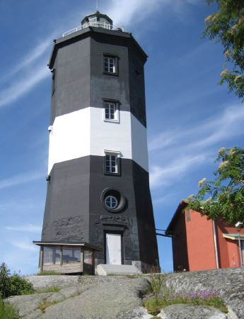
1848. Active; focal plane 32 m (105 ft); white light, 6 s on, 21 s off, 3 s on, 6 s off, 3 s on, 21 s off. 21 m (69 ft) octagonal old-style stone tower with lantern and gallery, painted black with one white horizontal band. Several 1-story wood keeper's houses and other light station buildings. Christine and Hagen Graf's photo is at right, Sari Pukkila has a more distant 2021 photo, a photo of the station is available, Tero Koski has a 2008 closeup of the light in action, and Marinas.com has aerial photos, but Google has only a distant satellite view. In 1987 this was the last Finnish lighthouse to be automated. The lighthouse is built on the island of Västra Norrskär in the center of the Gulf of Bothnia, about 50 km (35 mi) west of Vaasa. Located on a low hill on the southwestern peninsula of the island. Accessible only by boat. Site open, tower closed. . ARLHS FIN-033; SU-7191; Admiralty C4250; NGA 17912.
Norrkallan
Date unknown. Active; focal plane 9 m (30 ft); flash every 5 s, white, red or green depending on direction. Round concrete tower, painted red. No photo available but Bing has an indistinct satellite view. Located about 800 m (1/2 mi) west of Västra Norrskär. Accessible only by boat. Site open, tower closed. ARLHS FIN-082; SU-7192; Admiralty C4251; NGA 17916.
Norrskär Light
Norrskär Light, Kvarken, June 2008
Flickr Creative Commons photo by Christine and Hagen Graf
Östra Norrskär
Date unknown. Active; focal plane 12 m (39 ft); four flashes every 15 s, white, red or green depending on direction. 8.5 m (28 ft) square cylindrical tower with lantern and gallery. Tower painted black, lantern white. Marinas.com has aerial photos but Google has only a distant satellite view of the island. Located on the northeastern tip of the island of Östra Norrskär, about 7 km (4.5 mi) east northeast of the Norrskär lighthouse. Accessible only by boat. Site open, tower closed. SU-7412; Admiralty C4252; NGA 17908.
Utgrynnan
1960. Active; focal plane 24 m (79 ft); white, red or green light, depending on direction, 3 s on, 9 s off. Approx. 19 m (62 ft) round cylindrical concrete tower with lantern and gallery, painted with red and white horizontal bands. Tero Koski has an excellent photo and a view from the sea, Trabas has a very distant view, Marinas.com has aerial photos, and the shadow of the tower is conspicuous in Google's satellite view. The lighthouse replaced a lightship station established in 1868. Located on a small island about 20 km (13 mi) north northeast of Norrskär. Ferries crossing the gulf between Vaasa and Umeå, Sweden, probably pass close to this lighthouse. Accessible only by boat. Site open, tower closed. ARLHS FIN-072; SU-7453; Admiralty C4248; NGA 18172.
Valassaaret (Valsörarna)
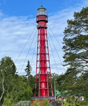
1886. Active; focal plane 38 m (125 ft); four white flashes every 20 s. 36 m (118 ft) hexagonal cast iron tower with lantern, central cylinder, and triple gallery. Entire structure painted red. The original 1st order Fresnel lens, removed in the 1980s, is on display at the Vaasan Merimuseo (maritime museum) in Vaasa. Piritta Syrjälä's 2023 photo is at right, Kristian Lindqvist has a photo, Jukka Aspbäck has a 2021 photo, Jarkko Mäki-Ista has a good photo, Jaana Hirsikangas has a 2018 photo, Marinas.com has aerial photos, Huelse has a historic postcard view, and Google has a fuzzy satellite view. This wonderful lighthouse was designed in Paris by Henry Lepaute, then working for the firm of Alexandre-Gustave Eiffel. It is unusually slender for its type, and guy wires have been added to steady it in the northern winds. Located on the island of Storskär, about 6 km (3.5 mi) northwest of Panike. Accessible only by boat. Site open, tower closed. . ARLHS FIN-076; SU-7179; Admiralty C4226; NGA 18148.
Ritgrund
1863 (substantially rebuilt in 1945). Active; focal plane 25 m (82 ft); two flashes every 10 s, white, red or green depending on direction. 18 m (59 ft) octagonal pyramidal wood tower (rebuilt with a steel skeletal frame) with lantern and gallery. Entire structure painted red. 2-story wood keeper's house and other buildings. Tero Koski has a fine photo, Chris Hart has a good photo, Trabas has a distant view, Marinas.com has aerial photos, and Bing has a satellite view. Located on a small island about 6 km (3.5 mi) northeast of Björkö. Accessible only by boat. Site open, tower closed. ARLHS FIN-048; SU-7161; Admiralty C4224; NGA 17824.


Valassaaret Light, July 2023
Instagram photo by Piritta Syrjälä


Nykarleby (Uusikaarlepyy) Lighthouses
Stubben
1954. Active; focal plane 21 m (69 ft); three long (2.5 s) white flashes every 30 s. Approx. 18 m (59 ft) lantern and gallery mounted atop a 4-story pilot station building. Upper half of the building painted black, lower half white: lantern and gallery painted white. Harri Nyman's photo is at right, the Swedish Lighthouse Society has a page for the lighthouse, Kåge Ahlsved has a good photo, Marinas.com has aerial photos, Trabas has a very distant view, and Google has a satellite view. Located on Lillskär, a small island about 3 km (2 mi) off the mainland and about 16 km (10 mi) west of Nykarleby. Accessible only by boat. Site open, tower closed. . ARLHS FIN-060; SU-7469; Admiralty C4219; NGA 18176.
[Storskäret]
Date unknown. Unlit daybeacon. 17 m (56 ft) octagonal pyramidal wood tower with a pyramidal roof. Entire tower painted dark red. Harri Nyman has a closeup photo, Kåge Ahlsved has a photo, and Google has a satellite view. Located on Storskär, an island just to the southeast of Lillskär. Accessible only by boat. Site open, tower closed.
[Hällgrund (1)]
Date unknown. Unlit daybeacon. Approx. 15 m (49 ft) octagonal pyramidal wood tower with a pyramidal roof. Lower 2/3 of the tower painted red, upper third white, roof black. Gunilla Tammenmaa has a photo, Per Johan Westerlund has a 2020 photo, the tower is in the background of Trabas's photo of the minor light C4217, and Google has a satellite view. Located on a low island off the north end of Torsön, about 5 km (3 mi) west of Pörkenäs. Accessible only by boat. Site open, tower closed.
Hällgrund (3) (Pentzinsgrund)
1903 (station established 1883). Active; focal plane 14 m (46 ft); two flashes every 6 s, white, red or green depending on direction. Approx. 13 m (43 ft) square skeletal tower with lantern and gallery, painted white. Kåge Ahlsved has a photo, Mattias Nilsson has a closeup street view, Trabas has a very distant view, and Google has a satellite view. This light is at the north end of the same island as the historic Hällgrund beacon (previous entry). Located on a low island off the north end of Torsön, about 5 km (3 mi) west of Pörkenäs. Accessible only by boat. Site open, tower closed. SU-7349; Admiralty C4218; NGA 18188.

Jakobstad (Pietarsaari) Lighthouses
Jakobstad (Pietarsaari in Finnish) is a town of about 19,000 residents located about 100 km (62 mi) northeast of Vaasa.

[Mässkär (2)]
1856 (station established early 1700s). Unlit daybeacon. Approx. 15 m (49 ft) hexagonal pyramidal wood tower with a pyramidal roof. Tower painted red; the roof is black. Kåge Ahlsved has a closeup photo and a view from the sea, and Google has a satellite view. The original beacon was demolished in 1854 during the Crimean War so that it would not aid British ships in a possible attack on Jakobstad. Located on the north side of Mässkär, a small island in the entrance to Pietarsaari. Accessible only by boat. Site open, tower closed.

Stubben Light and Pilot Station, Nykarleby, 1999
Wikimedia Creative Commons photo by Harri Nyman
Pietarsaari (Jakobstad)
1985. Active; focal plane 17 m (56 ft); white flash every 12 s. 17 m (56 ft) steel and concrete post light with a round cylindrical equipment shelter near the bottom and a gallery at the top. Upper half of the tower painted black, lower half yellow. Peter Granholm has a photo, Trabas has a very distant view, and the tower is seen in Google's indistinct satellite view. Located on a shoal about 9 km (4.5 mi) northwest of Pietarsaari, a small port more often called by its Swedish name Jakobstad. Accessible only by boat. Site open, tower closed. ARLHS FIN-040; SU-7340; Admiralty C4214.3; NGA 18197.
Kallan
1956. Active; focal plane 23 m (75 ft); two flashes every 6 s, white, red or green depending on direction. 19 m (62 ft) round cylindrical concrete tower with lantern and double gallery. Lighthouse painted red with one white horizontal band above the lower gallery. A photo is at right, Kåge Ahlsved has a photo, Jonas Thomén has a good view from the sea, Denise Björn-Lindell has a 2017 photo, Trabas has a distant view, and Google has a satellite view. Located on a small island about 1 km (0.6 mi) northwest of the Pietarsaari light. Accessible only by boat. Site open, tower closed. ARLHS FIN-014; SU-7339; Admiralty C4214; NGA 18196.
Bredhällan (Rummelgrund) Range Rear
Date unknown. Active; focal plane 22 m (72 ft); white light, 2 s on, 4 s off. 21 m (69 ft) triangular cylindrical skeletal tower carrying a large daymark colored red with a yellow vertical stripe. Trabas has a photo and the shadow of the tower is seen in Google's satellite view. This is an entrance range for Pietarsaari. Located on Bredhällan, an island across the entrance from the Mässkär beacon. Site open, tower closed. SU-7342; Admiralty C4212.1; NGA 18204.
Borgmästargrund (Hällören) Range Rear
Date unknown. Active; focal plane 20 m (66 ft); red light, 2 s on, 4 s off. 18 m (59 ft) triangular cylindrical skeletal tower carrying a large daymark colored red with a yellow vertical stripe. Trabas has a distant view and Bing has an indistinct satellite view. This is the final entrance range for Pietarsaari. Located at the northern tip of Hällören on the south side of Pietarsaari harbor. Site status unknown. SU-7344; Admiralty C4216.1; NGA 18212.

Kallan Light, Jakobstad, August 2021
Google Maps photo by TETRIX Portable Marketing

Central Ostrobothnia Region Lighthouses

Central Ostrobothnia (Keski-Pohjanmaa in Finnish; Mellersta Österbotten in Swedish) is mostly an inland region; it has a short coast in the Kokkala area.

Kokkola (Karleby) Lighthouses
Kokkola (Karleby in Swedish) is a city of about 48,000 residents; it is the only important port on the short coast of Central Ostrobothnia.
Tankar
1889. Active; focal plane 38 m (125 ft); white flash every 3.5 s. 30 m (98 ft) round cast iron tower with lantern and gallery. Lighthouse painted red with one white horizontal band; lantern dome is gray metallic. A photo is at right, Olli Pohjonen has a 2021 photo, a 2007 photo is available, Marinas.com has aerial photos, and Google has a satellite view of the station. In addition to the main light, the rear light of the Tankar Range (white light, 3 s on, 3 s off) is shown though a lower window of the tower at a focal plane of 20 m (66 ft). Located on a small island about 15 km (9 mi) west northwest of Kokkola. Accessible only by boat. Site open, tower closed. . ARLHS FIN-065; SU-9064; Admiralty C4200; NGA 18224.
Kokkola
1977. Active; focal plane 22 m (72 ft); two flashes every 10 s, white, red or green depending on direction. 23 m (75 ft) round cylindrical concrete tower, incorporating keeper's quarters, with lantern, two galleries, and a helipad on top of the lantern. Upper half of the lighthouse painted red, lower half white. No photo available and the lighthouse is not seen in Bing's satellite view. Located on a shoal about 12 km (7.5 mi) northwest of Kokkola. Accessible only by boat. Site open, tower closed. ARLHS FIN-020; SU-9071; Admiralty C4203; NGA 18240.
Ykspihlaja Breakwater
Date unknown. Active; focal plane 5 m (17 ft); continuous yellow light; the tower is also floodlit at night. 5 m (17 ft) octagonal cylindrical tower with lantern and gallery, painted white. Trabas has a photo, Pekka Määttänen has a photo, and Google has a satellite view. Ykspihlaja is the harbor area of Kokkola. The light is not on a breakwater pier; it is located on a concrete pad at the tip of an island that shelters the southern portion of the harbor. Site and tower closed. SU-9086; Admiralty C4209; NGA 18300.
Taulukari Range Front
Date unknown. Active; focal plane 21 m (69 ft); yellow light, 1 s on, 1 s off. Approx. 20 m (66 ft) steel mast on a concrete tower (according to NGA) carrying a large daymark colored red with a yellow vertical stripe. No photo available but Google has an indistinct satellite view. Located on an islet in Ykspihlaja harbor, about 1 km (0.6 mi) northeast of the breakwater light. Accessible only by boat. Site status unknown. SU-9077; Admiralty C4207; NGA 18268.
Taulukari Range Rear
Date unknown. Active; focal plane 30 m (98 ft); yellow light, 3 s on, 3 s off. Approx. 25 m (82 ft) square cylindrical skeletal tower carrying a large daymark colored red with a yellow vertical stripe. Trabas has a photo and Google has a satellite view. Located in the industrial zone of Ykspihlaja harbor about 1.46 km (0.9 mi) south southeast of the front light. Site and tower closed. SU-9078; Admiralty C4207.1; NGA 18272.
Tankar Light
Tankar Light, Kokkola, July 2006
Wikimedia Creative Commons photo by Tomisti
* Harrinniemi (Harrbåden, Trutklippan Range Rear (2))
1953. Inactive, at least since the early 1980s. Approx. 28 m (92 ft) round cylindrical unpainted concrete tower. It appears that the light was shown from a short skeletal tower at the top. Pentti Impiö has a photo, Wikimedia has Jukka Kolppanen's photo, and Bing has a satellite view. 2011 photos show that the tower is in poor condition. Located on a peninsula at the entrance to the harbor of Kokkola. Site open, tower closed.
Klädesklippan Range Rear
Date unknown. Active; focal plane 19 m (62 ft); yellow light, 2 s on, 4 s off. Approx. 18 m (59 ft) square cylindrical skeletal tower carrying a large daymark colored red with a yellow vertical stripe. Trabas has a distant view and Google has an indistinct satellite view. This is the next-to-last approach range for Kokkola. Located on a small island about 2 km (1.25 mi) northwest of the Kokkola waterfront. Site and tower closed. SU-9167; Admiralty C4206.1; NGA 18264.
Trutklippan Range Front (1)
1885. Inactive for many years. Approx. 7 m (23 ft) square wood tower at one end of a 1-story wood keeper's house. Tower painted red, house white.The light was shown from a window of the tower. Kåge Ahlsved has a photo and a second photo seen at right, Lamin Virnes has a street view, and Google has a satellite view. This was the original approach range for Karleby (Kokkola). The original rear light was 256 m (280 yd) southeast. This range was still in service in the 1920s and probably served until World War II. In more recent times the front light was an octagonal lantern and the rear light was the Harrinniemi lighthouse (previous entry). The old lighthouse is privately owned, probably as a vacation cottage. Located on Södra Trutklippan, a small island about 3 km (2 mi) northwest of Harrinniemi. Accessible only by boat. Site status unknown.
Trullögrund Range Rear
Date unknown. Inactive; charted as the rear beacon of a dayrange. Approx. 30 m (98 ft) round cylindrical concrete tower, upper half painted black and lower half white. Kåge Ahlsved has a 2008 photo and a 2011 photo and Bing has a satellite view. The range guides vessels leaving Kokkola northward. Located on a small island about 10 km (6 mi) north of Kokkola. Accessible only by boat. Site open, tower closed.
* Ohtakari
Date unknown. Active; focal plane 23 m (75 ft); continuous white light. Approx. 18 m (60 ft) square pyramidal skeletal tower, unpainted. Trabas has a photo, Mikko Lehtonen has a photo, Kåge Ahlsved has a photo of the light in action, and Google has an indistinct satellite view. Located in Ohtakari, a small harbor village at the end of a long promontory about 25 km (15 mi) north of Kokkola. Site open, tower closed. SU-9060; Admiralty C4194; NGA 18308.

Trutklippan Light, Kokkola, March 2019
Google Maps photo by Kåge Ahlsved

Information available on lost lighthouses:

Notable faux lighthouses:

Adjoining pages: North: North Ostrobothnia | South: Satakunta

Return to the Lighthouse Directory index | Ratings key

Posted October 8, 2007. Checked and revised October 9, 2023. Lighthouses: 47; lightships: 1. Site copyright 2023 Russ Rowlett and the University of North Carolina at Chapel Hill.