Lighthouses of Finland: Satakunta

The Republic of Finland (Suomi in Finnish) is a country of northern Europe with coastlines facing south on the Gulf of Finland (Suomenlahti) and west on the Gulf of Bothnia (Pohjanlahti), both arms of the Baltic Sea. Finland also administers the Åland Islands (Ahvenanmaa), an archipelago at the junction of the two gulfs. After centuries of rule by Sweden, Finland was conquered by Russia in 1809 and became an autonomous grand duchy within the Russian Empire. The country declared its independence from Russia at the start of the Russian Revolution in 1917. It lost some of its eastern territory to Russia as a result of World War II but has retained its independence.

Finland is divided into nineteen regions (maakunta) and the regions are divided into municipalities. This page includes the lighthouses of the Satakunta Region. The region faces west on the Bothnian Sea (known as Selkämeri in Finnish and Bottenhavet in Swedish), the southern portion of the Gulf of Bothnia. It is the widest and deepest portion of the gulf, occupying an elliptical basin about 300 km (185 mi) wide and 400 km (250 mi) long. Satakunta includes two major ports, Rauma and Pori.

The Finnish word for a lighthouse is majakka (plural majakat). Saari is an island, luoto is an islet or skerry, niemi is a cape or headland, niemimaa is a peninsula, lahti is a bay, salmi is a strait, joki is a river, and satama is a port or harbor. Swedish is a second official language in Finland and some of the lighthouses are commonly known by their Swedish names.

Lighthouses in Finland are maintained by the Waterways Section of the Finnish Transport Infrastructure Agency (Liikennevirasto).

ARLHS numbers are from the ARLHS World List of Lights. SU numbers are from the official Finnish light list. Admiralty numbers are from volume C of the Admiralty List of Lights & Fog Signals. U.S. NGA List numbers are from Publication 116.

General Sources
Online List of Lights - Finland
Photos by various photographers posted by Alexander Trabas.
Finskt fyrväsende
Photos and information posted by the Swedish Lighthouse Society.
Finnish Lighthouses
Excellent photos of the some of the better known lighthouses, taken by Mikko Rauhala.
Lighthouses in Finland
Photos by various photographers available from Wikimedia.
World of Lighthouses - Finland
Photos by various photographers available from Lightphotos.net.
Lighthouses in Finland
Aerial photos posted by Marinas.com.
Weitere Europäische Leuchttürme auf historischen Postkarten
Historic postcard images posted by Klaus Huelse.
List of Lights
The Finnish light list is available for download.
Finnish Lighthouse Society
The national lighthouse preservation association.
GPSNauticalCharts
Navigational chart for southwestern Finland.
Navionics Charts
Navigational chart for southwestern Finland.


Kylmäpihlaja Light, Rauma, June 2012
Wikimedia Creative Commons photo by Jari Sjölund

Rauma Lighthouses
Rauma is a city of about 40,000 residents located 92 km (57 mi) north of Turku. Known for shipbuilding and paper products, Rauma is the fifth busiest Finnish port.
Rauma
1981. Active; focal plane 22 m (72 ft); two flashes every 10 s, white, red or green depending on direction. 23 m (75 ft) round cylindrical concrete tower with lantern, double gallery, and a helipad on top. Lighthouse painted red. Anne Jacksen's photo is at right and Trabas has a distant view, but the lighthouse is not shown in Google's satellite view. Located on a shoal about 16 km (10 mi) due west of Rauma. Accessible only by boat. Site open, tower closed. . ARLHS FIN-046; SU-3067; Admiralty C4417; NGA 17268.
[Santkari Beacon]
1857. Unlit daybeacon. Approx. 20 m (66 ft) octagonal wood tower with a pyramidal roof. Tower painted red with white trim. Koto Kaaho has a 2018 photo, Palo Seliga has a drone view, Erkki Keskiväli has a distant view from the mainland, and Google has a satellite view. The Town of Rauma restored this historic tower in 2009. Located on a small island at the start of the southern approach to Rauma. Accessible only by boat. Site open, tower closed.
Rihtniemi Range Front
Date unknown. Active; focal plane 14 m (46 ft); white light, 2 s on, 2 s off. 14 m (46 ft) square skeletal tower carrying a large rectangular daymark colored red with a yellow vertical stripe. Trabas has a photo and Google has a satellite view. This is the outer approach range for Rauma. Located on a reef about 1.2 km (3/4 mi) northwest of the rear light (next entry). Accessible only by boat. Site open, tower closed. SU-3068; Admiralty C4418; NGA 17272.
Rihtniemi Range Rear
Date unknown. Active; focal plane 26 m (85 ft); white light, 6 s on, 6 s off. 23 m (75 ft) triangular skeletal tower carrying a large daymark colored red with a yellow vertical stripe. Trabas has a photo and the shadow of the tower is seen in a Google satellite view. Located at the end of a mainland peninsula about 13 km (8 mi) southwest of the Rauma waterfront. Site status unknown. SU-3069; Admiralty C4418.1; NGA 17276.
Urmluoto Range Rear
Date unknown. Active; focal plane 34 m (111 ft); white light, 3 s on, 3 s off. 29 m (95 ft) triangular skeletal tower carrying a large daymark colored red with a yellow vertical stripe. Trabas has a photo and Google has a satellite view. The front light is on an 18 m (59 ft) steel post. This is the second approach range for vessels approaching Rauma. Located at the end of a mainland peninsula about 8 km (5 mi) southwest of the Rauma waterfront. Site status unknown. SU-3471; Admiralty C4418.31; NGA 17284.

Rauma Light, Bothnian Sea, July 2019
Instagram photo by Anne Jacksen
Iso Järviluoto Range Rear
Date unknown. Active; focal plane 41 m (134 ft); green light, 3 s on, 3 s off. Approx. 35 m (115 ft) square skeletal mast carrying a large daymark colored red with a yellow vertical stripe. Trabas has a photo and Google has a satellite view. The front light is on a post. This is the third range for vessels approaching Rauma. Located on the small island of Vähä Järviluoto on the south side of Rauma harbor. Accessible only by boat. Site status unknown. SU-3071; Admiralty C4419.1; NGA 17312.
Hakuni Range Rear
Date unknown. Active; focal plane 25.5 m (84 ft); white light, 3 s on, 3 s off. Approx. 30 m (98 ft) square skeletal mast also carrying lights illuminating the harbor area. Part of the tower is seen in the background of Trabas's photo of the front light and Google has a satellite view. This is the entrance range for Rauma harbor. Located inside the container terminal at the west end of the Rauma docks. Site open, tower closed. SU-3073; Admiralty C4419.71; NGA 17321.1.
Satama Range Rear
Date unknown. Active; focal plane 29.5 m (97 ft); continuous white light. Approx. 35 m (115 ft) triangular skeletal mast also carrying lights illuminating the harbor area. Trabas has a photo and Google has a satellite view. Located inside the commercial harbor. Site and tower closed. SU-3075; Admiralty C4434.1; NGA 17406.1.
*** Kylmäpihlaja
1953. Active; focal plane 36 m (118 ft); four white flashes every 45 s. 32 m (105 ft) square cylindrical brick tower, originally incorporating keeper's quarters, attached to a large 2-story coast guard building. Jari Sjölund's photo is at the top of this page, the Swedish Lighthouse Society has a page for the lighthouse, Carlos Raposo has an August 2007 photo, Trabas has an excellent photo, Wikimedia has several photos, and Google has a satellite view. This large lighthouse was leased or sold in 2002 and it has been converted into a hotel and restaurant operated by Suvi and Tom Lindqvist. Located on an island about 10 km (6 mi) west of Rauma; accessible during the summer months by daily passenger ferry service from Rauma. Site open; hotel, restaurant, and tower open daily early June through late August. Site manager: Kylmäpihlajan Majakkahotelli . SU-3500; ARLHS FIN-024; Admiralty C4421; NGA 17328.
Kylmäpihlajan Aallonmurtaja (Kylmäpihlaja South Breakwater)
Date unknown. Active; focal plane 9 m (30 ft); white, red or green light, depending on direction, 1.5 s on, 1.5 s off. 9 m (30 ft) square cylindrical skeletal tower carrying a large daymark colored red with a yellow vertical stripe. Trabas has a closeup photo, Pekka Laitinen has a nice view of the harbor entrance looking toward the main lighthouse, and Google has a satellite view. This was formerly the rear light of a range. Located on the south breakwater of the Kylmäpihlaja harbor. Site status unknown but there's a good view from arriving ferries. SU-3080; Admiralty C4421.41; NGA 17329.1.

Eurajoki Lighthouses
Kalla (1 and 2)
Date unknown. Active; focal plane 10.5 m (34.5 ft); flash every 5 s, white, red or green, depending on direction. The active light is on a 9 m (30 ft) triangular skeletal tower; next to it is the older pyramidal skeletal tower. Niko Haapanen has a 2017 photo and Google has a satellite view. Located on a small island about 20 km (13 mi) north of Rauma. Accessible only by boat. Site open, tower closed. SU-3048; Admiralty C4406; NGA 17436.
Säppi (Björneborg, Sebbskär)
1873. Active; focal plane 35 m (115 ft); two white flashes, followed 12.7 s later by a single white flash, every 30 s. 31 m round two-stage white tower with lantern and gallery, the lower third cylindrical and the upper 2/3 conical. Lighthouse painted white; lantern dome is red. 1-story wood keeper's house, wood barn, and other buildings, painted red. A photo is at right, the Swedish Lighthouse Society has a page for the lighthouse, another photo is available, Juha Grönroos has a drone view, Marinas.com has aerial photos, and Google has a satellite view. Säppi is an island about 1.5 km (1 mi) long, located about 10 km (6 mi) southwest of Mäntyluoto. Located on the highest point of the island. Accessible only by boat. Site open, tower closed. SU-7445; ARLHS FIN-055; Admiralty C4398; NGA 17448.

Säppi Light, Säppi, August 2009
Wikimedia Creative Commons photo by kallerna

Pori Lighthouses
Pori is a city of about 85,000 residents located about 50 km (30 mi) north of Rauma.
Levo Range Rear
Date unknown. Active; focal plane 26 m (85 ft); white light, 6 s on, 6 s off. Approx. 22 m (72 ft) square skeletal mast. Trabas has a photo and Google has a satellite view and a distant street view. This is the approach range for Mäntyluoto. Located beside warehouse on the southeast side of Mäntyluoto. Site status unknown. SU-28427; Admiralty C4384.51; NGA 17463.1.
* Kallo (Range Front)
1884. Active; focal plane 11 m (36 ft); white, red or green light, depending on direction, 1 s on, 1 s off. 8 m (26 ft) octagonal cast iron tower with eight ribs, lantern and double gallery, attached to a 1-story wood keeper's house. Lighthouse painted white, house red with white trim. A photo is at right, Leo Rantala has a 2011 photo, Trabas has a photo, Wikimedia has numerous photos, Veli-Mikko Ikonen has a street view, and Google has a satellite view. The rear light, known as Uniluoto, is on a billboard-style tower. This attractive and historic lighthouse guides vessels into the port of Mäntyluoto, northwest of Pori. Located on the peninsula sheltering the west side of the harbor. Site open, tower closed. . ARLHS FIN-015; SU-7328; Admiralty C4376; NGA 17456.
* Kallo-Tiepenger Range Rear
Date unknown. Active; focal plane 29 m (95 ft); white light, 2 s on, 4 s off. 27 m (89 ft) triangular cylindrical skeletal tower carrying a large daymark colored white with a red vertical stripe. Trabas has a photo and Google has a satellite view and a street view. The front light is on a much shorter tower. This is the final approach range for Mäntyluoto. Located beside highway 269 on a causeway section of the crossing from Mäntyluoto to Reposaari. Site open, tower closed. SU-7439; Admiralty C4384.1; NGA 17500.

Kallo Light, Mäntyluoto, October 2011
Flickr Creative Commons photo by Leo-setä
* Räfsö (Reposaari Breakwater)
Date unknown. Active; focal plane 10 m (33 ft); four quick flashes every 6 s, white, red or green depending on direction. 6 m (20 ft) round cylindrical tower with lantern and gallery. Lighthouse painted white with a red horizontal band just below the gallery. Trabas has a closeup photo, Karri Ojanen has another closeup photo, a third photo is available, and Google has a street view (also seen at right) and a satellite view. Reposaari and Mäntyluoto are separated by their common harbor entrance. Located on the waterfront of Reposaari. Site open, tower closed. ARLHS FIN-140; SU-7379; Admiralty C4378; NGA 17480.
* Reposaari Range Rear
Date unknown. Active; focal plane 23 m (75 ft); continuous red light. Approx. 21 m (69 ft) round chimney-like brick tower. Trabas has a photo and Google has a street view and a satellite view. The range guides vessels northward within the harbor. The front light is on a skeletal mast. Located at the end of Konttorinkatu street in Reposaari. Site open, tower closed. SU-7381; Admiralty C4394.1; NGA 17488.
Kaijakari
1933. Active; focal plane 20 m (66 ft); two white flashes every 20 s. Approx. 16 m (52 ft) square pyramidal steel skeletal tower with lantern and gallery. Lighthouse painted white; the upper half of the tower is covered on all sides by a vertically slatted brown daymark. Antti J. Lind has good photo, Trabas has a distant view, Marinas.com has aerial photos, and Bing has a satellite view. Located on Kaija, a small island about 3 km (2 mi) west of Reposaari. Accessible only by boat. Site open, tower closed. ARLHS FIN-012; SU-7378; Admiralty C4374; NGA 17452.

Räfsö Light, Mäntyluoto, May 2009
Google Maps street view
Tahkoluoto Range Front
Date unknown. Active; focal plane 13 m (43 ft); quick-flashing green light. 12 m (39 ft) square cylindrical skeletal tower carrying a large daymark colored red with a yellow vertical stripe. Trabas has a view from the sea and Google has a satellite view. This is an approach range for Reposaari from the north. The rear light is a tall billboard-style tower. Located on the industrial waterfront at the north end of Reposaari. Site and tower closed. SU-3043; Admiralty C4366; NGA 17510.
Leppäkari Range Rear
Date unknown. Active; focal plane 26 m (85 ft); white light, 2 s on, 4 s off. Approx. 23 m (75 ft) square cylindrical skeletal tower carrying a large daymark colored white with a red vertical stripe. Trabas has a photo and Google has a satellite view. The front light is on a short skeletal tower atop a concrete pedestal. Located at an industrial complex about 10 km (6 mi) north of Reposaari. Site status unknown. SU-3046; Admiralty C4370.1.
Pori (2)
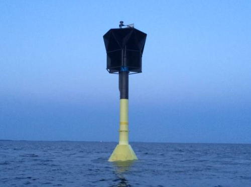
2016 (station stablished 1985). Active; focal plane 18 m (59 ft); white flash every 12 s. 18 m (59 ft) concrete post with the upper portion surreounded by a large hexagonal structure. Lower half of the lighthouse painted yellow, upper half black. Marko Reilimo has the photo of the new structure seen at right on his Twitter feed and Bing has a satellite view. Antti J. Lind has a page with a 2007 photo of the original, taller tower. Located on a shoal in the Gulf of Bothnia about 12 km (7.5 mi) northwest of Reposaari. Accessible only by boat. Site open, tower closed. ARLHS FIN-041; SU-3042; Admiralty C4365; NGA 17534.
 

Pori Light, Gulf of Bothnia, May 2016
Twitter photo by Marko Reilimo
 

Information available on lost lighthouses:

Notable faux lighthouses:

Adjoining pages: North: Ostrobothnia | South: Southwest Finland | Southwest: Åland Islands

Return to the Lighthouse Directory index | Ratings key

Posted October 8, 2007. Checked and revised September 30, 2023. Lighthouses: 20. Site copyright 2023. Russ Rowlett and the University of North Carolina at Chapel Hill.