Lighthouses of Finland: Lakes

The Republic of Finland (Suomi in Finnish) is a country of northern Europe with coastlines facing south on the Gulf of Finland (Suomenlahti) and west on the Gulf of Bothnia (Pohjanlahti), both arms of the Baltic Sea. Finland also administers the Åland Islands (Ahvenanmaa), an archipelago at the junction of the two gulfs. After centuries of rule by Sweden, Finland was conquered by Russia in 1809 and became an autonomous grand duchy within the Russian Empire. The country declared its independence from Russia at the start of the Russian Revolution in 1917. It lost some of its eastern territory to Russia as a result of World War II but has retained its independence.

Finland has a large number of lakes and inland waterways, and this page describes smaller lighthouses found on these waterways.

The Finnish word for a lighthouse is majakka ("beacon," plural majakat). Saari is an island, luoto is an islet or skerry, niemi is a cape or headland, niemimaa is a peninsula, lahti is a bay, salmi is a strait, joki is a river, and satama is a port or harbor. Swedish is a second official language in Finland and some of the lighthouses are commonly known by their Swedish names.

Lighthouses in Finland are maintained by the Waterways Section of the Finnish Transport Infrastructure Agency (Liikennevirasto).

ARLHS numbers are from the ARLHS World List of Lights. SU numbers are from the official Finnish light list.

General Sources
Lighthouses in Finland
Photos by various photographers available from Wikimedia.
Finland - World of Lighthouses
Photos by various photographers available from Lightphotos.net.
Finnish Lighthouse Society
The national lighthouse preservation association.
List of Lights
The Finnish light list is available for download.
GPSNavigationCharts
Navigation chart information for the lakes.
Navionics Charts
Navigation chart for the lakes.


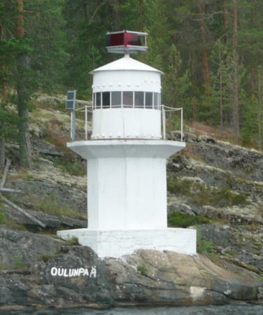
Oulunpää Light, Saimaa, July 2008
ex-Panoramio photo copyright Jari Hurri; used by permission
Saimaa Waterway Lighthouses

Northern Saimaa Lighthouses
Saimaa (pronounced SY-mah), the largest lake in Finland and the fourth largest lake in Europe, is located in the southeast of the country near the Russian border. The lake surface has a normal elevation of 75.7 m (248 ft). Unlike the nearby Russian lakes Ladoga and Onega, Saimaa is not a single open body of water; it is an intricate system of waterways with numerous branches. Pihlajavesi and Haapaselkä are portions of the Lake Saimaa system northeast of Puumala. The lake drains naturally to Lake Ladoga via the Vuoksi River. For navigational access the Saimaa Canal connects the lake more directly to the Baltic at Vyborg, Russia. The portion of the canal in Russia is leased to Finland by an agreement extending to 2063.

Rastiniemi
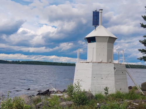
Date unknown. Active; focal plane 5.5 m (18 ft); two quick flashes every 3 s, white, red or green depending on direction. 5 m (16 ft) hexagonal lantern standing on a hexagonal masonry base. Entire lighthouse is white. A photo is at right, the light is in the lower right corner of an aerial photo, and Google has a distant satellite view. This light is located on the eastern side of Paasselkä, a circular basin of the upper lake about 10 km (6 mi) in diameter, confirmed in 1999 to be a 200 million year old meteor crater. Accessible only by boat. Site open, tower closed. SU-22344.
Papinsaari
Date unknown. Active; focal plane 7 m (23 ft); two quick flashes every 3 s, white, red or green depending on direction. 6 m (20 ft) octagonal white concrete tower with a pyramidal base. Petri Laitinen has a photo and Google has a distant satellite view. This light is located on the northwestern side of the Paasselkä basin. Accessible only by boat. Site open, tower closed. SU-22442.

Rastiniemi Light, Saimaa, July 2022
Google Maps photo by Tanjukka K
Torakkaluoto
Date unknown. Active; focal plane 4.5 m (17 ft); two quick flashes every 3 s, white, red or green depending on direction. 4 m (13 ft) iron lantern, painted white, mounted on a stone pier. Jari Hurri has a closeup photo, Timo Seppäläinen has a photo, and Google has a distant satellite view. Located on the west side of a narrow passage between two basins of the lake about 10 km (6 mi) northwest of Savonlinna. Accessible only by boat. Site open, tower closed. SU-13812.
Ilokallio
Date unknown. Active; focal plane 5 m (17 ft); two quick flashes every 3 s, white, red or green depending on direction. 6 m (20 ft) octagonal lantern mounted on a round stone base. Lantern painted white, base painted with black and white vertical stripes. Google has a distant street view and an indistinct satellite view. Located on a small island in the approach to Savonlinna from the north. Accessible only by boat. Site and tower closed (private property). SU-13795.
* Savonlinna
Date unknown. Active but probably unofficial. 4 m (13 ft) iron lantern, painted white, mounted on a concrete pad. Anton Bolenkov has a street view and Google has an indistinct satellite view. The lantern was probably relocated to this position for display. Located on the grounds of the Savonlinna Provincial Museum on Riihisaari island in Savonlinna. Site open, tower closed.
Varisluoto
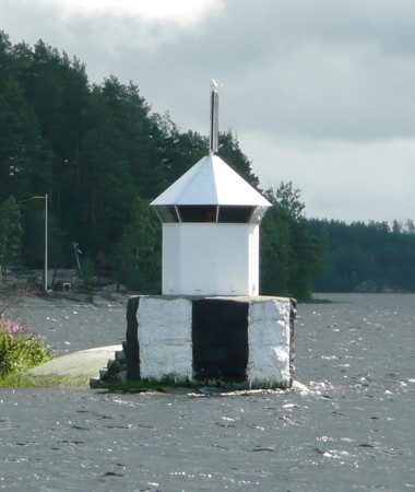
Date unknown. Active; focal plane 5 m (17 ft); five very quick white flashes every 6 s. 6 m (20 ft) octagonal lantern mounted on a stone pier. Lantern painted white, pier painted with black and white vertical stripes. Jari Hurri's closeup photo is at right and Google has an indistinct satellite view. The light marks the beginning of the approach to Savonlinna from the south, about 5 km (3 mi) south of the city. Accessible only by boat. Site open, tower closed. SU-13538.
Tuohiluoto (3?)
Date unknown. Active; focal plane 6.5 m (22 ft); two very quick flashes every 3 s, white, red or green depending on direction. 5 m (17 ft) octagonal lighthouse mounted on a round stone base. Lighthouse painted white. Jar Hurri has a 2008 photo and Google has a distant satellite view. Eerik Hocksell's 2004 photo shows that the original lantern had been replaced temporarily by a light on a mast. Located on an island in a narrow passage of the lake about 30 km (19 mi) southwest of Savonlinna. Accessible only by boat. Site open, tower closed. SU-13725.
Varisluoto Light
Varisluoto Light, Saimaa, July 2008
ex-Panoramio photo copyright Jari Hurri; used by permission
Southern Saimaa Lighthouses
Vekara
Date unknown. Inactive. 5 m (18 ft) octagonal lantern mounted on a stone base. Lighthouse painted white. Eerik Hocksell has a photo, Google has a distant street view, and Bing has a satellite view. The active light has been moved to a location 250 m (820 ft) offshore. Located on the west side of the lake north of the Vekara ferry terminal. Site status unknown. ex-SU-15705.
Lehtosaari
Date unknown. Active; focal plane 6 m (20 ft); two very quick flashes every 3 s, white, red or green depending on direction. 5 m (17 ft) round lantern mounted on a round stone or concrete pier. Lighthouse painted white. Jari Hurri has a photo, Eerik Hocksell also has a photo and Google has a distant satellite view. Located on an island in the Kolmisalmi channel leading to the southeastern sections of the lake. Accessible only by boat. Site open, tower closed. SU-14404.
Oulunpää
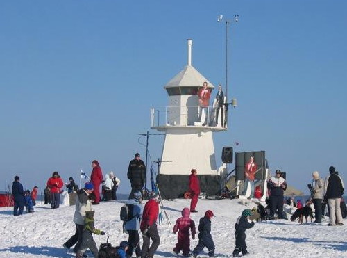
Date unknown. Active; focal plane 7.5 m (25 ft); two very quick flashes every 3 s, white, red or green depending on direction. 6 m (20 ft) octagonal cylindrical tower with lantern and gallery, painted white; the directional light is now mounted atop the lantern. Jari Hurri's photo is at the top of this page, another photo is available, and Bing has a distant satellite view. The light marks a narrow passage near a right-angled bend in the lake. Located in the Pihlajavesi portion of Saimaa on the southeastern coast of the island of Oulunsaari. Accessible only by boat. Site open, tower closed. SU-14403.
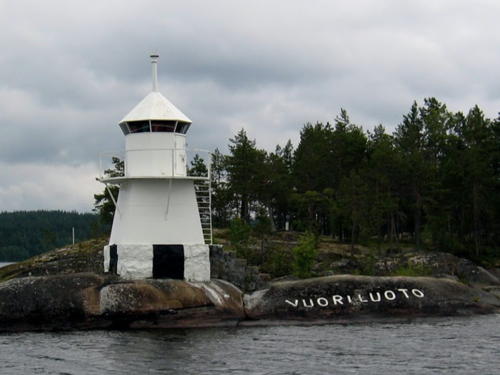
Vuoriluoto
Date unknown. Active; focal plane 7 m (23 ft); two very quick flashes every 3 s, white, red or green light depending on direction. 6 m (20 ft) square pyramidal solid concrete tower with lantern and gallery, painted white. A photo is available, Eerik Hocksell has a closeup (also seen at right), Risto Ollila has a 2017 view from the lake, and the light is barely visible in a Google satellite view. Located on the north end of an island in Haapaselkä about 12 km (7.5 mi) northeast of Puumala. Accessible only by boat. Site open, tower closed. SU-22357.

Vuoriluoto Light, Saimaa, July 2004
Google Maps photo by Eerik Hocksell
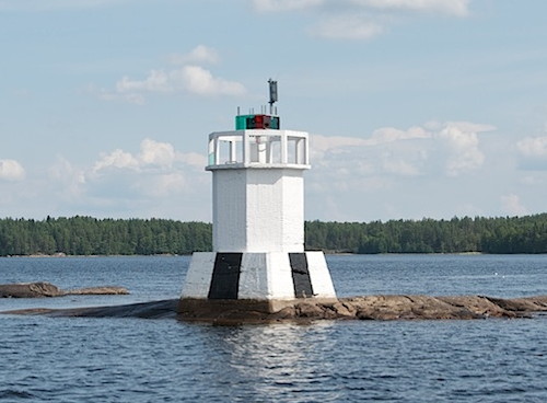
Osmonaskel (Puumala)
Date unknown. Active; focal plane 6 m (20 ft); two quick flashes every 3 s, white, red or green light depending on direction. 6 m (20 ft) octagonal cylindrical tower with gallery, painted white. Lantern removed. The lighthouse stands on a square pier painted white with a black vertical stripe on each face. Riku Kettunen's photo is at right, Eerik Hocksell has a closeup, and Google has a very distant satellite view. Located on the west side of Haapaselkä about 2.5 km (1.5 mi) northeast of Puumala. Accessible only by boat. Site open, tower closed. SU-20462.
Rehusaari (Saukionniemi)
Date unknown (station established 1885 as Saukionniemi). Active; two quick flashes every 3 s, white, red or green light depending on direction. 4 m (13 ft) octagonal lantern mounted on a square concrete base. Lantern painted white; base painted with black and white vertical stripes. Eerik Hocksell has a photo, a 2021 view from the lake is available, and Google has a distant satellite view. Located on a small island off the northeast side of the island of Kyläniemi in the southern portion of Saimaa. Accessible only by boat. Site open, tower closed. SU-22355.
Rastinluoto (Rastiluoto)
Date unknown. Active; focal plane 7.5 m (25 ft); three very quick flashes every 3 s, white, red or green light depending on direction. 6 m (20 ft) octagonal lantern mounted on an octagonal concrete base; the directional light is now mounted atop the lantern. Lantern painted white; base painted with black and white vertical stripes. A photo is available and Google has an indistinct satellite view. Located on a small island in the Taipalsaari municipality, on a part of Lake Saimaa known as Riutanselkä, about 15 km (9 mi) northwest of Lapeenrenta. Accessible only by boat. Site open, tower closed. SU-13583.
Puumala Light
Osmonaskel Light, Saimaa, July 2011
Flickr Creative Commons photo by Riku Kettunen
Laivaluoto
Date unknown. Active; focal plane 6 m (20 ft); five very quick flashes every 6 s, white, red or green light depending on direction. 6 m (20 ft) round lantern mounted on a square stone base; the directional light is now mounted atop the lantern. Lantern painted white; base painted with black and white vertical stripes. Eerik Hocksell has a photo and Google has a satellite view. Located on a reef near the southern end of Lake Saimaa, about 6 km (4 mi) northeast of Joutseno. Accessible only by boat. Site open, tower closed. SU-14050.

Päijänne Waterway Lighthouses

Keitele Lighthouse
Keitele is a lake north of Jyväskylä in central Finland. The Keitele Canal, completed in 1993, connects lakes Keitele and Päijänne, forming a inland navigation route of about 400 km (250 mi).

Tallisaari (Suolahti)
Date unknown. Active; five very quick yellow flashes every 6 s. 7 m (23 ft) octagonal cylindrical tower with lantern and gallery, painted white. A photo and a second photo are available, and Bing has a distant satellite view. Located on a small island in the harbor of Suolahti, the town at the south end of the lake. Accessible only by boat. Site open, tower closed. SU-50136.

Päijänne Lighthouses
Päijänne is Finland's second largest lake, some 120 km (75 mi) in length, extending southward from Jyväskylä, the capital of the Central Finland region. It is the principal water source for Helsinki, the national capital. The lake drains through the Kymi River to the Gulf of Finland near Kotka.

*
Muuratsalo (Haikka)
Date unknown. Active; flash every 3 s, white, red or green depending on direction. 4 m (13 ft) octagonal lantern, painted white and mounted on a concrete pier atop a large boulder. A photo and a second photo are available, Harri Lamminpää has a 2020 photo, Wikimedia has Antti Leppänen's photo, and Google has a satellite view. Located on a gravel bar sheltering the harbor of Haikka, a village about 20 km (13 mi) south of Jyväskylä on the west side of the lake. Site open, tower closed. SU-28264.
Judinsalo
Date unknown. Active; quick yellow flash every 1 s. 8 m (26 ft) octagonal cylindrical tower with lantern and gallery, painted white. The light carries automated weather instruments. A closeup photo is available, Wikimedia has Mika Särkijarvi's view from the lake, and Bing has a distant satellite view. Located on a small island east of Lahtela in the central portion of the lake. Accessible only by boat. Site open, tower closed. SU-28252.
Tehinsilmä
Date unknown. Active; yellow light, 2 s on, 2 s off, 2 s on, 4 s off. 9 m (30 ft) square pyramidal concrete tower with lantern and gallery; access to the light is by an external stairway. Lighthouse painted white. A 2008 photo is available and Google has a satellite view. Located on a rock called Mustalaisluoto, on the SE side of Tehinkärki Point near Kuhmoinen. Accessible only by boat. Site open, and anyone can climb the stairs. SU-28245.
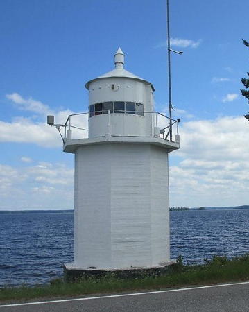
* Pulkkila (Pulkkilanharju)
Date unknown. Active; flash every 3 s, white, red or green depending on direction. 10 m (33 ft) octagonal cylindrical concrete tower with a large round lantern and gallery, painted white. Andreas Köhler's photo is at right, Tero Viitanen has a 2018 photo, Ilkka Hämäläinen has a 2022 photo, and Google has a street view and a satellite view. Pulkkilanharju is an 8 km (5 mi) long ridge that crosses the southern part of the lake. Highway 314 uses the ridge and several bridges to make the same crossing. Located beside highway 314 near a bridge crossing a gap in the ridge. Site open, tower closed. ARLHS FIN-084; SU-28197.
Majakka Paviljonki (Vääksy pohjoinen)
Date unknown. Active; focal plane 12 m (39 ft); five quick white flashes every 6 s. Light mounted on the roof of a popular restaurant. Ilkka Hämäläinen has a street view and Google has a satellite view. The light marks the northern entrance to the Vääksy Canal connecting Päijänne to Vesijärvi. Site open, tower closed. Site manager: Majakkapaviljonki . SU-28196.

Pulkkila Light, Päijänne, 2013
photo copyright Andreas Köhler; used by permission

Vesijärvi Lighthouse
Vesijärve is a smaller lake south of Päijänne but connected to Päijänne by a short canal. The city of Lahti is at the south end of Vesijärvi.

*
Vesijärven Satama 1 (Lahti Pierhead)
Date unknown. Active; red flash every 3 s. 6 m (20 ft) square tower with lantern topped by a windvane. Tower painted white with two red horizontal bands. Wikimedia has Tiia Monto's closeup photo, another photo is available, and Google has a satellite view and a winter street view taken from the frozen lake. Located at the end of the main quay of Lahti; cruises depart from this pier. Accessible by walking the pier. Site open, tower closed. SU-35311.

Näsijärvi Waterway Lighthouses

Näsijärvi Lighthouses
Näsijärvi, a lake in southwestern Finland, is about 40 km (25 mi) in length north to south and has a normal elevation of 95 m (312 ft) above sea level. Tampere, the largest city of inland Finland, is located at the south end of the lake.

Teisko (Tesikola)
Date unknown. Active (?); characteristics unknown. 5 m (17 ft) octagonal cast iron tower with lantern and gallery, painted white. A photo and a second photo are available and Google has a satellite view. Located near Teisko, a town on a northeastern arm of the lake. Site open, tower closed. Not found in the Finnish light list.
Siilinkari
Date unknown. Active; five quick white flashes every 6 s. 6 m (20 ft) square pyramidal tower with lantern and gallery, painted white. A photo is at right, Antti Kivivalli has a closeup photo, Matti Luiro has a 2017 photo, Elena Nissi has a 2021 photo, Dhanushka Sathurusinghe has a 2023 photo, a portfolio of photos is available, and Google has a satellite view. This is one of the best known lighthouses of the Finnish lakes. Located on a small island in the lake about 1.3 km (0.8 mi) north of the Tampere waterfront. Accessible only by boat. Site open, tower closed. SU-28843.

Information available on lost lighthouses:

Notable faux lighthouses:

Siilinkari Light
Siilinkari Light, Tampere, March 2006
Wikimedia public domain photo by Zacc

Adjoining pages: East: Lake Ladoga | South: Kymenlaakso | Southwest: Uusimaa

Return to the Lighthouse Directory index | Ratings key

Posted March 2, 2010. Checked and revised September 9, 2023. Lighthouses: 24. Site copyright 2023 Russ Rowlett and the University of North Carolina at Chapel Hill.