Lighthouses of Fiji

Located in the central South Pacific Ocean, the Republic of Fiji (Viti in Fijian) was a British colony from 1874 to 1970. There are more than 300 islands in the archipelago, more than 100 of them inhabited. However, most of the population lives on the two largest islands, Viti Levu and Vanua Levu. (The English name Fiji, introduced by the explorer Capt. James Cook, is the Tongan pronunciation of Viti.) The population of the country is approaching one million.

There are several historic lighthouses in Fiji but very little information is available about them. Photos and accounts of visits are certainly needed. A major problem is that most Fijian lighthouses are at remote locations not accessible except by boat.

For administration Fiji is divided into four divisions and the divisions are subdivided into a total of 14 provinces.

The Fijian word for a lighthouse is valencina; yanuyanu is an island, serau is a shoal, toa is a reef, and toba is a harbor.

Navigational aids in Fiji are managed by the Maritime Safety Authority of Fiji (MSAF), a "commercial statutory authority" established in 2011. The new authority had to address the problem that many of the lights were reported to be out of action. In January 2013, shipping companies protested the government's failure to "provide proper beacons and lighthouses in the country after spending years operating without the essential maritime aid," according to the Fiji Times. Fortunately a new program of modernizing the system of navigational aids has gotten underway. In late March 2013 a program to construct eight new lighthouses was announced and in January 2014 a second program of nine lighthouses was announced.

ARLHS numbers are from the ARLHS World List of Lights. Admiralty numbers are from volume K of the Admiralty List of Lights & Fog Signals. U.S. NGA List numbers are from Publication 111.

General Sources
Online List of Lights - Fiji
Photos by various photographers posted by Alexander Trabas. Fiji photos are by Rainer Arndt and Erich Hartmann.
World of Lighthouses - Fiji
Photos by various photographers available from Lightphotos.net.
South Pacific Lighthouses
Photos taken in 2017 by Larry Myhre.
Leuchttürme Australiens, Neuseelands und Ozeaniens auf historischen Postkarten
Historic postcard images posted by Klaus Huelse.
GPSNavigationCharts
Navigational chart information for Fiji.
Navionics Charts
Navigational chart information for Fiji.

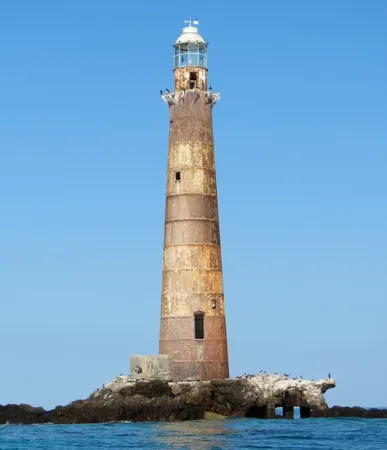
Solo Light, Great Astrolabe Reef, September 2016
photo copyright Di Fitzgerald; used by permission

Northern Division (Vanua Levu Area) Lighthouses

Macuata Province (Northern Vanua Levu) Lighthouses
Qelelevu (Nggele Levu, Naqelelevu) (?)
Date unknown. Active; focal plane 33 m (108 ft); two white flashes every 12 s. 27 m (89 ft) skeletal tower. No photo available but Google has a satellite view. This light marks the extreme northeastern corner of the Fiji archipelago. Located near the east end of Qelelevu, an atoll in Macuata Province about 100 km (60 mi) east of Vanua Levu. Accessible only by boat. Site status unknown. ARLHS FIJ-014; Admiralty K4756; NGA 3264.
Udu Point (Cape Undu) (2)
Date unknown (station established 1912). Active; focal plane 49 m (161 ft); two white flashes every 25 s. 6 m (20 ft) white hexagonal tower on a concrete base. No photo available but Google has a satellite view. The original lighthouse was descibed as a hexagonal tower on iron piles. Located at the end of a long peninsula on the northeastern tip of Vanua Levu. Site status unknown. Admiralty K4748; NGA 3268.
Malau
Date unknown. Active (privately maintained); focal plane 18 m (59 ft); continuous red light. 16 m (52 ft) square skeletal tower, described by NGA as a bulk loading tower. Prem Krishneel Singh has a photo and Google has a satellite view. The Port of Malau ships molasses from sugar plantations on Vanua Levu. Located on a deep bay on the north side of eastern Vanua Levu. Site and tower closed. Owner/site manager: Fiji Sugar Corporation. Admiralty K4747; NGA 3272.
Kia Island (?)
Date unknown. Active; focal plane 70 m (229 ft); white flash every 5 s. 8 m (26 ft) metal tower. No photo available and the light is not seen in Google's satellite view. Located near the northern tip of Kia, a high island off the central north coast of Vanua Levu. Site open, tower closed. Admiralty K4746.5; NGA 3284.

Cakaudrove Province (Southeast Vanua Levu) Lighthouses
Point Reef (Lesiaceva Point, Savusavu Bay)
Date unknown. Active; focal plane 7.5 m (25 ft); white flash every 3 s. 9 m (29 ft) hexagonal cylindrical concrete tower, painted white. Terry Gray has a photo (second photo on the page), Will and Lauren Robinson have a photo (3/4 the way down the page), the lighthouse is visible at the right in Richard Johnson's aerial photo of the reef, and Google has a distant satellite view. This is a very popular scuba diving site but few visitors have posted photos of the lighthouse. Located near the western end of the reef fringing Savusavu Bay on the south side of the island of Vanua Levu. Accessible only by boat. Site open, tower closed. ARLHS FIJ-009; Admiralty K4744; NGA 3276.
Taveuni Island (Vuna Point)
Date unknown. Active; focal plane 10 m (33 ft); white flash every 8 s. 10 m (33 ft) white concrete tower. A photo is at right and Google has a distant satellite view. Taveuni is a substantial island off the south coast of Vanua Levu. Located near the end of the reef off Vuna Point, the southwestern end of the island. Accessible only by boat. Site open, tower closed. Admiralty K4750; NGA 3288.

Vuna Point Light, Taveuni
contributed photo copyright Dilip

Eastern Division Lighthouses

Lau Province Lighthouses
The Lau Islands include about sixty islands and reefs scattered around the east and southeast of Fiji. The total population of the islands is barely 10,000.

#Wailagilala (Welagilala, Wailagi Lala) (2)
About 1909 (station established 1894). Reported extinguished as of 1997 (probably much earlier); demolished or collapsed by 2015. This was 29 m (95 ft) cast iron tower, originally painted white but long since rusted to a reddish color. Lantern removed. Michel Forand has a historic postcard view and Bing has a satellite view. This lighthouse was built on a small atoll of the same name (in its various spellings). The northernmost of the Lau Islands, Wailagi Lala is placed dangerously in the middle of the Nanuku Passage, the primary entrance to the Fiji Islands from the northeast. The island was sold in 2007 to be developed as a "luxury private retreat" and the Wailagilala Tropical Island Resort was open by 2015. Apparently it failed; its web site and Facebook page have disappeared. The original lighthouse was a wood skeletal tower. The 1909 lighthouse was abandoned for many years although it continued to be carried on official light lists. In 2014 bids were received for a new 30 m (98 ft) tower (next entry). The resort formerly had a March 2015 photo showing the historic lighthouse lying on the ground; we don't know if it collapsed or was cut down like a giant tree. Site open. ARLHS FIJ-005.
Wailagilala (Welagilala, Wailagi Lala) (3)
2015 (station established 1894). Active; focal plane 30 m (98 ft); white flash every 5 s. 30 m (98 ft) square cylindrical skeletal tower carrying a modern LED beacon. A view from the lagoon is at right. Probably located close to the original lighthouse (no change in coordinates has been announced). Site open, tower closed. Admiralty K4752; NGA 3260.

Wailagi Lala Light, Lau Islands, March 2015
Facebook photo courtesy of Wailagilala Tropical Island Resort
Vatoa
Date unknown. Active; focal plane 70 m (230 ft); white flash every 5 s. 30 m (98 ft) skeletal tower. No photo available but Google has an indistinct satellite view. Vatoa is a small island at the extreme southeastern end of the Fiji archipelago. Located at the highest point of the island. Site status unknown. ARLHS FIJ-003; Admiralty K4759; NGA 3492.
Totoya
Date unknown. Active; focal plane 76 m (249 ft); three white flashes every 10 s. 15 m (49 ft) skeletal tower. No photo available and Google has only a fuzzy satellite view of the area. Totoya is an island about 150 mi (240 km) southeast of Viti Levu. Located on heights at the southwestern end of the island. Site status unknown. ARLHS FIJ-015; Admiralty K4758; NGA 3488.

Kadavu Province Lighthouses
Kadavu, the fourth largest island of Fiji, is the largest of the Kadavu Islands, located about 100 km (62 mi) south of Viti Levu. The islands are enclosed within the Great Astrolabe Reef, one of the largest island-enclosing barrier reefs in the world.

Cape Washington (Kadavu, Kandavu) (2) (?)
Date unknown (station established 1902). Active; focal plane 63 m (207 ft); white flash every 5 s. 8 m (26 ft) square skeletal tower with gallery. No photo available and the tower is not seen in Google's satellite view. Located at the western tip of Kadavu. Site status unknown. Admiralty K4662; NGA 3480.
Vanuatabu (Vanuatambu)
Date unknown. Active; focal plane 50 m (164 ft); white flash every 2 s. Skeletal tower, height unknown. No photo available but Google has a satellite view. Located on a small island off the southeast coast of Kadavu. Accessible only by boat. Site status unknown. Admiralty K4663; NGA 3484.
Solo (North Astrolabe Reef)
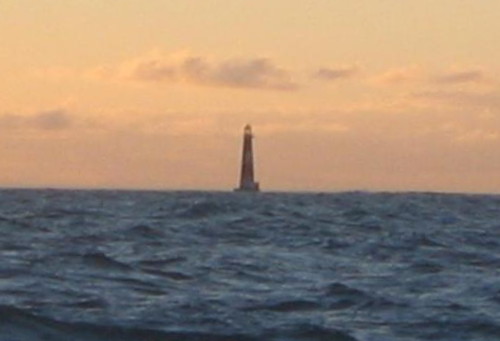
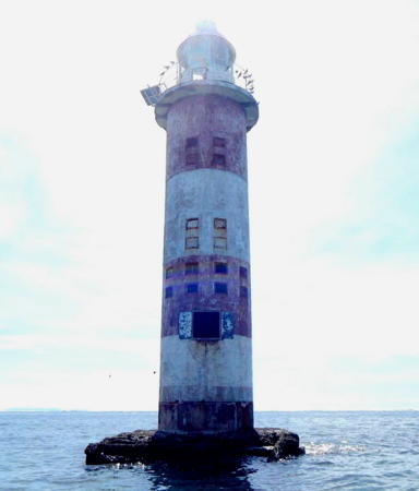
1888. Reported inactive; focal plane 29 m (96 ft); white light, 3 s on, 27 s off. 32.5 m (106 ft) cast iron tower, painted white with two red horizontal bands. Di Fitzgerald's photo is at the top of this page, Myhre has a 2017 photo, Trabas has Jim Smith's photo, and Bing has a satellite view. McCabe found the lighthouse inactive and in poor condition. Located on Solo Rock, a tiny island enclosed by the Great Astrolabe Reef, northeast of Kadavu Island about 65 km (40 mi) southeast of Suva. Accessible only by boat. ARLHS FIJ-002; Admiralty K4666; NGA 3476.

Lomaiviti Province Lighthouses
The islands of the Lomaiviti group lie in the Koro Sea, south of Vanua Levu and east of Viti Levu. Levuka, the largest town of the islands, was an early site of European colonization and the capital of Fiji from 1871 to 1877.

Korolevu (Koro, Muanivanua Point) (2)
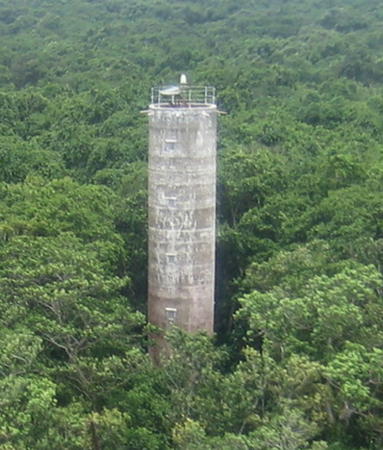
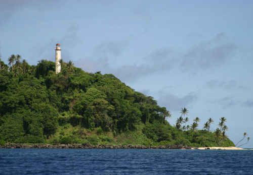
1910 (station established 1902). Inactive. Approx. 25 m (82 ft) round cylindrical tower with lantern and gallery. Lighthouse painted white, lantern roof red. A photo is at right, an undated photo showing this lighthouses and the next one is available and Google has a satellite view. The original light was on a square 9 m (30 ft) tower. The 1910 lighthouse appears abandoned and endangered. Koro is an inhabited island about 65 km (40 mi) south of Savusavu and a similar distance northeast of Levuka. Located on a promontory on Muanivanua Point at the south end of the island. Site status unknown. ARLHS FIJ-010.
Korolevu (Koro, Muanivanua Point) (3) (?)
Date unknown (station established 1902). Inactive since 2014. 25 m (82 ft) square skeletal tower with gallery. An undated photo showing this and the previous one is available. In 2013 the Maritime Safety Authority listed this as one of eight sites for new lighthouses. The light has now been moved to the new tower, and the the older one is abandoned. Located about 100 m (110 yd) east of the historic lighthouse. Site status unknown.
Korolevu (Koro, Muanivanua Point) (4)
2014. Active; focal plane 62 m (203 ft); two white flashes every 10 s. 12 m (39 ft) concrete tower painted white with one red horizontal band. No photo available but Google has a satellite view. Site status unknown. Admiralty K4740; NGA 3292.

1910 Muanivanua Point Light, Koro, undated
unattributed photo, apparently from a tourist site, via Pinterest
Cakau Momo (Thakau Momo)
2013. Active; focal plane 6 m (20 ft); white flash every 2 s. 6 m (20 ft) round white concrete tower, top painted red. No photo available but Bing has a satellite view. Located on the southwest side of an atoll about 25 km (15 mi) east of the Wakaya Reefs lighthouse and a similar distance northeast of Batiki. Accessible only by boat. Site open, tower closed. Admiralty K4733; NGA 3296.
Batiki (Mbatiki) Island (Irene Point)
Date unknown. Active; focal plane 35 m (115 ft); white flash every 4.5 s. 6 m (30 ft) octagonal white concrete tower mounted on a square concrete base. No photo available but Google has a satellite view. Batiki is a small island about 40 km (25 mi) southeast of Ovalau. Located on the northwestern point of the island. Site status unknown. Admiralty K4732; NGA 3316.
Wakaya Reefs (2)
Date unknown (station established 1902). Inactive since 2016. 25 m (83 ft) hexagonal tower with lantern and gallery, painted with red and white horizontal bands. The crew of the schooner Seawanhaka has posted the distant view (first photo in the last row) also seen at right, and Google has a satellite view. The original lighthouse was described as a hexagonal tower on piles. This lighthouse is abandoned and clearly endangered. Wakaya is a privately owned resort island off the northeast coast of Viti Levu. The lighthouse is located near the south end of the reef, roughly 15 km (9 mi) southeast of the island and 25 km (15 mi) due east of Levuka. Accessible only by boat. Site open, tower closed. ARLHS FIJ-004.
Wakaya Reefs Light
Wakaya Reefs Light, 2005
photo copyright Bill Hanlon; used by permission
Wakaya Reefs (3)
2016. Active; focal plane 13 m (43 ft); two white flashes every 15 s. 13 m (43 ft) white concrete tripod. No photo available but Google has a satellite view. This is another new light in Fiji's recent program to modernize its navigational aids. Located about 400 m (1/4 mi) north of the previous light. Accessible only by boat. Site open, tower closed. Admiralty K4730; NGA 3312.
North Ovalau Island (Ovalau Reef, Loba Loba) (2)
Date unknown (station established 1977). Active; focal plane 12 m (39 ft); two white flashes every 10 s. 12 m (39 ft) post rising from a round concrete tower mounted on a round platform supported by three piles. No photo available but Bing has a satellite view. NGA describes a black skeletal tower on a concrete base. The light was converted to a solar-powered LED light in 2013. Located at the entrance through the reef at the northeast corner of Ovalau Island. Accessible only by boat. Site open, tower closed. ARLHS FIJ-008; Admiralty K4719; NGA 3332.
Levuka Harbour (Na Tumbari) Range Front
Date unknown (station established 1898). Active; focal plane 14.5 m (48 ft); continuous blue light. 15 m (50 ft) square Gothic stone church tower carrying a green neon-lit tube on a red triangular slatted daymark as the front range light. A photo is at right, Kirsti Medig also has a photo of the church, a closeup shows the light and daymark well, and Google has a satellite view. The light is located on the Sacred Heart (Catholic) Church, built in 1858, one of Fiji's most historic buildings. The rear range light is another neon sign on a building behind the church. Na Tumbari is opening in the reef east of Levuka. An earlier range, established in 1876, had two beacons high on the hill behind the town. Located in Levuka, Fiji's first capital, now a national historic site, on Ovalau Island east of Viti Levu. Site open, tower closed. ARLHS FIJ-007; Admiralty K4722; NGA 3336.
Levuka Entrance
Date unknown. Active; focal plane 9 m (30 ft); white flash every 2 s. 10 m (33 ft) round concrete tower with gallery supported by a robust concrete tripod. The lighthouse is unpainted white concrete. A 2008 photo is available and Google has a fuzzy satellite view. Located on the south side of the Na Tumbari entrance through the reef east of Levuka. Accessible only by boat. Site open, and nothing prevents visitors from climbing the tower. Admiralty K4723; NGA 3352.

Harbour Range Front Light, Levuka, August 2017
ex-Google Plus photo by Rodney S.

Central Division Lighthouses

Viti Levu is Fiji's largest island and the home of 70% of the country's population. Suva, the national capital, is on the southeast side of the island. Other large population centers include Nadi and Lautoka, both on the west end of the island. Suva is built on a peninsula separating Laucala Bay on the east from Suva Harbour on the west.

Naitasiri Province Lighthouse
Nasilai Reef (2)
Date unknown (station established 1886). Active; focal plane 14 m (46 ft); two long (2 s) white flashes every 30 s. 16.5 m (54 ft) round cylindrical tower with lantern and gallery, painted with horizontal red and white bands. A Fiji Ports Corporation photo is at right, John Stewart has a 2015 photo, a distant view is available, and Google has a satellite view. Nasilai Reef is a very dangerous coral reef off the southeastern corner of Viti Levu, endangering ships on their approach to Suva. The original lighthouse, described as being on piles, was built after the ship Syria wrecked on the reef in 1884 with the loss of 70 lives. Located at the southeastern extremity of the reef. Accessible only by boat. Site open, tower closed. ARLHS FIJ-001; Admiralty K4668; NGA 3368.

Rewa Province (Suva Area) Lighthouses
Makuluva Islet
Date unknown. Active; focal plane 18 m (59 ft); white flash every 10 s. 18 m (59 ft) mast mounted on a square white concrete base. No photo available but Google has a satellite view. Located on the east side of the narrow pass into Laucala Bay. Accessible only by boat. Site open, tower closed. Admiralty K4670; NGA 3372.
Suva East Reef (2)
Date unknown. Active; focal plane 10 m (33 ft); green flash every 5 s. 11 m (36 ft) square pyramidal skeletal tower painted green. Trabas has Arndt's photo, another photo (second row, right) is available and Google has a satellite view. This light replaced an octagonal concrete tower. The entrance to Suva Harbour is through an opening in the reef about 500 m (0.3 mi) wide. Located at the north end of the reef on the east side of the entrance through the reef into Suva, Fiji's capital. Accessible only by boat. Site open, tower closed. Admiralty K4678; NGA 3404.
Suva Hospital (2?)
Date unknown. Active; focal plane about 30 m (98 ft); continuous red light. Approx. 25 m (82 ft) communications tower topped by a flagstaff. Trabas has Arndt's photo and Google has a satellite view. This light has little navigational value today but for many years it has been listed, and is still listed by NGA, as "Flagstaff on Hospital roof." Located within the hospital complex. Site status unknown. Admiralty K4687; NGA 3384.
Suva North Side (Entrance) Range Front
Date unknown (station established 1880). Active; focal plane 40 m (131 ft); quick-flashing blue light. Round tower rising from a square base. Tower painted red with a white horizontal band. No photo available but Google has a satellite view. The tower height is not known, but the 1916 Pacific Islands Pilot (p. 299) describes these range lights as "conspicuous beacons." NGA notes that the range lights are "liable to be obscured by smoke," presumably from cooking fires. Located off Nakula Street in Lami, a residential area northwest of Suva and at the head of Suva Bay. Site status unknown, but the light should be visible from nearby streets. Admiralty K4672; NGA 3396.
Nasilai Reef Light
Nasilai Reef Light, Suva
Fiji Ports Corporation photo
Suva North Side (Entrance) Range Rear
Date unknown (station established 1880). Active; focal plane 103 m (338 ft); blue light, 2 s on, 2 s off. Round tower rising from a square base. Tower painted red with a white horizontal band. No photo available but Google has a satellite view. The tower height is not known, but the 1916 Pacific Islands Pilot (p. 299) describes these range lights as "conspicuous beacons." Located on a steep hillside about 1.2 km (3/4 mi) north northwest of the front light. Site status unknown. Admiralty K4672.1; NGA 3400.
Suva West Reef (2)
Date unknown. Active; focal plane 9 m (30 ft); red flash every 3 s. 10 m (33 ft) tripod tower painted red. Trabas has Arndt's photo, Bill Strong has a distant photo and Google has a satellite view. The post on the left in the satellite view is a former light. This is known as the best surfing location in the Suva area. Located on the west side of the entrance through the reef into Suva, Fiji's capital. Accessible only by boat. Site open, tower closed. Admiralty K4676; NGA 3412.
Beqa (Mbengga Island)
Date unknown. Active; focal plane 12 m (39 ft); three white flashes every 12 s. 12 m (39 ft) tripod tower. No photo available but Google has a satellite view. Beqa is an island about 10 km (6 mi) off the south coast of Viti Levu west of Suva. Located just off the southeastern corner of the island, guiding vessels inside the reef. Accessible only by boat. Site open, tower closed. Admiralty K4694; NGA 3472.

Western Division Lighthouses

Nadroga-Navosa Province: Vatulele Lighthouse
Vatulele
1953. Active; focal plane 41 m (135 ft); white flash every 10 s. Approx. 21 m (69 ft) round cylindrical concrete tower. The lighthouse is unpainted white concrete. A photo is at right and Google has a satellite view. The British engineer Richard Whidborne designed and built the lighthouse; the day after it was completed it survived a magnitude-6 earthquake. Vatulele is an island about 12 km (7.5 mi) long from north to south, located about 50 km (30 mi) off the southwestern coast of Viti Levu. The island has several small resorts and is accessible by air from Suva. The lighthouse is located atop a vertical cliff on the northwestern point of the island. Site open; there are reports of visitors who were able to climb the tower. ARLHS FIJ-018; Admiralty K4661; NGA 3464.

Nadroga-Navosa Province: West Coast Viti Levu Lighthouses
Navula Reef (2)
Date unknown (station established 1886). Active; focal plane 11 m (36 ft); red flash every 3 s. 11 m (36 ft) post rising from a round concrete tower mounted on a round platform supported by three piles. Trabas has Hartmann's photo and Google has a satellite view. The original lighthouse had a listed height of 18 m (59 ft). This light marks the entrance through the reef for Momi, a port at the southwestern tip of Viti Levu. Located at the south end of Navula Reef, about 15 km (9 mi) southwest of Nadi. Accessible only by boat. Site open, tower closed. Admiralty K4702; NGA 3424.
Navula Passage (2?)
Date unknown. Active; focal plane 11 m (36 ft); green flash every 3 s. 11 m (36 ft) post rising from a round concrete tower mounted on a round platform supported by three piles. Trabas has Hartmann's photo and Google has a satellite view. Located at the north end of the reef opposite the Navula Reef lighthouse. Accessible only by boat. Site open, tower closed. Admiralty K4703.
Momi Bay Range Front (2)
2012 (station established 1911). Active; focal plane 10 m (33 ft); quick-flashing white light. 12 m (39 ft) light mounted on a round platform supported by three concrete piles. The tower carries a daymark painted red with a white vertical stripe. A closeup photo is available and Google has a satellite view. This is an entrance range for the Navula Reef pass, which leads ultimately to Nadi. In 2012 the light was relocated on a new structure; Google also has a satellite view showing the original platform, about 200 m (220 yd) to the west. Located at the water's edge in Momi Bay, about 8 km (5 mi) northeast of the Navula Reef light. Accessible only by boat. Site open, tower closed. ARLHS FIJ-006; Admiralty K4704; NGA 3432.

Vatulele Light, February 2007
Flickr photo copyright Nuff Nuff; used by permission
Momi Bay Range Rear
1911. Active; focal plane 63 m (207 ft); quick-flashing white light. 7 m (23 ft) square white concrete skeletal tower carrying a rectangular daymark colored red with a white vertical stripe. Tiun Kian Seng has a street view and Google has a satellite view. Located on a hilltop 1.9 km (1.2 mi) east northeast of the front light. Accessible by road. Site open, tower closed. ARLHS FIJ-012; Admiralty K4704.1; NGA 3436.
Navula Point
Date unknown. Active; focal plane 11 m (36 ft); green flash every 2 s. 11 m (36 ft) post rising from a round concrete tower mounted on a round platform supported by three piles. Trabas has Hartmann's photo and Google has a satellite view. Located just off a prominent cape about 5 km (3 mi) north of Momi. Accessible only by boat. Site open, tower closed. Admiralty K4706; NGA 3428.

Ba Province: Northwest Viti Levu Lighthouses
Naikorokoro (2)
Date unknown (station established 1906). Active; focal plane 13 m (43 ft) (?); two white flashes every 6 s. Triangular skeletal tower, height unknown. No photo available but Google has a satellite view. For many years the light was on a 16 m (52 ft) tower, described as a "white structure on black piles," and was located offshore. It has been moved onshore, probably in 2014. The light guides vessels approaching Lautoka on the northwest coast of Viti Levu. Located on a promontory about 6.5 km (4 mi) southwest of Lautoka. Site open, tower closed. Admiralty K4710; NGA 3440.
[Pinder Reef]
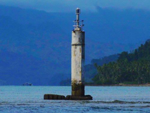
Date unknown. Active; focal plane 6 m (20 ft); white flash every 8 s. 6 m (20 ft) round tower painted black with a white horizontal band, mounted on a square concrete platform supported by tripod concrete piles. Myhre has a photo (also seen at right), Trabas has Hartmann's photo and Google has a satellite view. Located about 3 km (2 mi) off the Lautoka waterfront. Accessible only by boat. Site open, tower closed. Admiralty K4710.5; NGA 3441.

Ba Province: Yasawa Islands Lighthouse
Viwa
Date unknown. Active; focal plane 17 m (56 ft); three white flashes every 15 s. 15 m (49 ft) white skeletal tower. No photo available and the tower is not seen in Google's satellite view of the station. Viwa is the westernmost island of Fiji. Located on the northwestern point of the island. Site status unknown. ARLHS FIJ-016; Admiralty K4714; NGA 3460.

Pinder Reef Light, Lautoka, April 2017
Flickr Creative Commons photo by Larry Myhre

Information available on lost lighthouses:

Notable faux lighthouses:

Adjoining pages: North: Wallis and Futuna | East: Tonga | West: Vanuatu

Return to the Lighthouse Directory index | Ratings key

Posted January 3, 2006. Checked and revised October 25, 2023. Lighthouses: 38. Site copyright 2023 Russ Rowlett and the University of North Carolina at Chapel Hill.