Lighthouses of Vanuatu

The Republic of Vanuatu is an independent nation in the southwest Pacific Ocean, west of Fiji and northeast of New Caledonia. During the colonial period Britain and France maneuvered inconclusively to gain control of the archipelago. Finally, in 1906, the two countries worked out an arrangement for jointly administering the islands as the Condominium of the New Hebrides. The country became independent in 1980 with the name Vanuatu.

Vanuatu has some 65 inhabited islands in a loose, volcanic chain about 1300 km (800 mi) long. The capital is Port Vila on the island of Efate in the central part of the chain. The second largest town is Luganville on the island of Espiritu Santo near the northern end of the country. During World War II Luganville was an important base for Allied naval forces fighting the Japanese at Guadalcanal in the Solomon Islands.

The common spoken language in Vanuatu is Bislama, an English-based creole. For example, in Bislama laet haos is a lighthouse, aelan is an island and rif is a reef. English and French are also official languages.

Aids to navigation in Vanuatu are the responsibility of the Ports and Marine Department. Port Vila and Luganville are the only international ports.

ARLHS numbers are from the ARLHS World List of Lights. Admiralty numbers are from volume Kof the Admiralty List of Lights & Fog Signals. Light List numbers are from NGA Publication 111.

General Sources
World of Lighthouses - Vanuatu
Photos by various photographers available from Lightphotos.net.
South Pacific Lighthouses
Photos taken in 2017 by Larry Myhre.
Online List of Lights - Vanuatu
Photos by various photographers posted by Alexander Trabas. Vanuatu photos are by Rainer Arndt.
Vanuatu Map
Thiis map is from the Encyclopedoa Britannica.
GPSNauticalCharts
Navigational chart information for Vanuatu.
Navionics Charts
Navigational chart information for Vanuatu.


Pango Point Light, Efate, April 2017
Flickr Creative Commons photo by Larry Myhre

Santo (Espiritu Santo) Lighthouses
Espiritu Santo is the largest island of Vanuatu. Its principal settlement, Luganville, is located at the southeastern corner of the island.

Palikoulo Point (Naoréuré Point) (2?)
Date unknown. Active; focal plane 23 m (75 ft); three white flashes every 15 s. 21 m (69 ft) "white pylon," according to NGA. No photo available and the light is not seen in Bing's satellite view. Previously described as a white skeletal tower. Located on a promontory at Pêcherie, about 8 km (5 mi) east of Luganville near the southeastern corner of Espiritu Santo. Site probably open, tower closed. ARLHS VAN-004; Admiralty K4880; NGA 3496.
Tutuba Island
Date unknown. Active; focal plane 24 m (79 ft); one long white flash every 5 s. 21 m (69 ft) "white pylon," according to NGA. No photo available and the light is not seen in Google's satellite view. Located on the southeast side of Tutuba Island, where it serves as a landfall light for Luganville. Accessible only by boat. Site status unknown. ARLHS VAN-005; Admiralty K4877; NGA 3512.
* Million Dollar Point (2)
Date unknown. Active; focal plane 12 m (39 ft); four white flashes every 60 s. Approx. 15 m (49 ft) square skeletal tower, painted white with one red horizontal band. B.J. Hughes has the 2018 photo at right, Nick Gent has a photo, Andrew James has a 2023 photo, and Google has a satellite view. NGA formerly listed a 10 m (33 ft) square concrete tower. The light marks the north side of the eastern entrance to Luganville. The promontory came to be called Million Dollar Point after the U.S. military sank a fortune in surplus equipment offshore at the end of World War II. This underwater junkyard is now a very popular site for scuba divers. Located about 5 km (3 mi) east of Luganville. Accessible by road. Site open, tower closed. Admiralty K4880.4; NGA 3500.
Chapuis Point (Aoré Island)
Date unknown. Active; focal plane 24 m (79 ft); two flashes every 10 s, white, red or green depending on direction. 20 m (66 ft) white skeletal tower. No photo available but Google has an indistinct satellite view. This leading light through the Scorff Passage north of Tutuba Island into Luganville. Located on Chapuis Point at the northeastern corner of Aoré Island. Accessible only by boat. Site status unknown. ARLHS VAN-002; Admiralty K4880.6; NGA 3504.

Million Dollar Point Light, Luganville, July 2018
Google Maps photo by B.J. Hughes

Malakula Lighthouse
Lamap Point (2?)
Date unknown. Active; focal plane 35 m (115 ft); white flash every 10 s. Approx. 20 m (66 ft) tower with a square gallery or enclosure at the top. This light was formerly described by NGA as a skeletal tower but now as a white post, height unknown, painted white. No photo available but Google has a satellite view. Malakula is the second largest island of Vanuatu. Located on a headland at the entrance to the bay of Lamap, near the southeastern end of the island. Site status unknown. Admiralty K4868; NGA 3524.

Epi Lighthouse
Cape Foreland
Date unknown. Active; focal plane 207 m (679 ft); four white flashes every 20 s. 20 m (66 ft) square skeletal tower, painted white. Red-roofed keeper's house. No photo available but Google has a satellite view. Located atop a high promontory on the west side of the island of Epi, in central Vanuatu. Site status unknown. ARLHS VAN-001; Admiralty K4862; NGA 3540.

Efate Lighthouses
Efate is the most populous island of Vanuatu and about two thirds of its 66,000 inhabitants live in the national capital, Port Vila.
Pango Point (3)
2014 (station establishment date unknown). Active; focal plane 22 m (72 ft); white flash every 6 s. 22 m (72 ft) two-stage tower, including a 7 m (23 ft) aluminum skeletal tower mounted atop a 15 m (49 ft) square cylindrical concrete tower. The tower is unpainted. Larry Myhre's photo is at the top of this page, Trabas has a similar view by Arndt, and Google has a satellite view. Built by local contractors without heavy equipment, this lighthouse replaced a 22 m (72 ft) skeletal tower toppled by Tropical Cyclone Uma in 1987. Located on a promontory on the east side of the entrance to the natural harbor of Port Vila. Site open, tower closed. Admiralty K4852; NGA 3572.
* [Port Vila (Directional Light)]
Date unknown. Active; focal plane 43 m (141 ft); continuous white, red or green light, depending on direction. 6 m (20 ft) triangular slatted daymark, painted orange, standing on an octagonal white concrete pedestal. A photo is available, Trabas has Arndt's closeup, and Google has a satellite view. Located on a bluff overlooking the harbor of Port Vila. Site open. Admiralty K4854; NGA 3552.
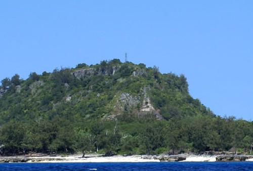
Érétoka Island (Retoka Island, Hat Island)
1960s. Reported inactive but listed with focal plane 96 m (315 ft); two white flashes every 10 s. 20 m (66 ft) square skeletal tower with gallery. Peter Watts's distant view of the lighthouse is at right but the tower is not seen in Google's satellite view of the charted location. The island does resemble a hat from a distance. According to comments on the Panoramio.com original of the photo, the lighthouse was built privately by Ernie Reid, who held a lease on the island. It has been abandoned and inactive since sometime in the 1970s. In 1967 the grave of the legendary 13th century Melanesian chieftain Roi Mata was discovered on the island, and as a result the island is now recognized as a UNESCO World Heritage Site. Located atop an island off the west coast of Efate. Accessible only by boat. Site status unknown. ARLHS VAN-003; Admiralty K4858; NGA 3560.

Eretoka (Hat) Island Light, September 2007
ex-Panoramio photo copyright Peter Watts; used by permission

Erromango Lighthouse
Ountovin Point
Date unknown. Active; focal plane 167 m (548 ft); two white flashes every 10 s. 15 m (49 ft) skeletal tower, painted white. No photo available but Bing has an indistinct satellite view. Located atop a high promontory on the west side of the island of Erromango, a large but sparsely populated island in southern Vanuatu. Site status unknown. Admiralty K4847; NGA 3576.

Information available on lost lighthouses:

Adjoining pages: North: Solomon Islands | East: Fiji | South: New Caledonia

Return to the Lighthouse Directory index | Ratings key

Posted February 14, 2009. Checked and revised November 1, 2023. Lighthouses: 9. Site copyright 2023 Russ Rowlett and the University of North Carolina at Chapel Hill.