Lighthouses of France: Northern Finistère

France (officially the French Republic, République française) has coasts facing south on the Mediterranean Sea, west on the open Atlantic Ocean, and north on the English Channel (La Manche in French). Long a leader in lighthouse design, France has scores of famous and historic lighthouses. And it was a French engineer and physicist, Augustin-Jean Fresnel (1788-1837), who invented the powerful and beautiful lenses used in lighthouses around the world.

France's Département du Finistère (Department of the End of the World) occupies the rugged western end of the peninsula of Bretagne (Brittany). Its dangerous coastline is crowded with lighthouses, more than in any other region of France. So many, in fact, that the Directory needs three pages to cover them all. This page includes lighthouses on the northern coast of the département, facing northwest on the Celtic Sea and the entrance to La Manche (the English Channel).

The French word for a lighthouse, phare, is often reserved for the larger coastal lighthouses; a smaller light or harbor light is called a feu (literally "fire," but here meaning "light") or a balise (beacon). The front light of a range (alignement) is the feu antérieur and the rear light is the feu postérieur. In French île is an island, cap is a cape, pointe is a promontory or point of land, roche is a rock, récife is a reef, baie is a bay, estuaire is an estuary or inlet, détroit is a strait, rivière is a river, and havre is a harbor. The Breton word for a lighthouse is tour-tan; enez is an island, and men is a rock or reef.

Aids to navigation in France are maintained by the Bureau des Phares et Balises, an agency of the Direction des Affaires Maritimes (Directorate of Maritime Affairs). The Directorate has four regional offices (called Directions Interrégionale de la Mer, or DIRM) at Le Havre, Nantes, Bordeaux, and Marseille. Lights in Brittany are managed by the DIRM Nord-Atlantique - Manche Ouest (DIRM-NAMO) at Nantes.

ARLHS numbers are from the ARLHS World List of Lights. FR numbers are the French light list numbers, where known. Admiralty numbers are from volume A of the Admiralty List of Lights & Fog Signals. U.S. NGA List numbers are from Publication 114.
Phare de l'Île de Batz
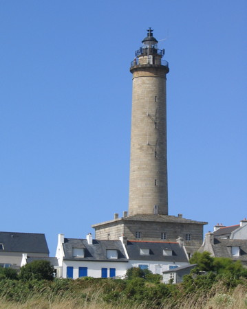
Île de Batz Light, August 2009
Wikimedia Creative Commons photo by Thesupermat

General Sources
DIRM - Phares du Finistère
Information on the major historic lighthouses.
Les Sentinelles des Mers - France - Bretagne
Photos and information posted by Guy Detienne.
Online List of Lights - France North Coast
Photos by various photographers posted by Alexander Trabas. Many photos for Finistère are by Capt. Peter Mosselberger ("Capt. Peter").
Le Phare à travers le Monde
A large, well known site maintained by Alain Guyomard and Robert Carceller.
Silhouettes des Phares
Photos and information posted by M. Mocquant.
Phareland, le Site des Phares de France
This comprehensive site has good photos and information about the major lighthouses.
Leuchttürme.net - Frankreich
Photos and notes by Malte Werning.
Lighthouses in Finistère
Photos available from Wikimedia.
Liste des phares du Finistère
A map locating the lighthouse and an index to articles in the French Wikipédia.
France Lighthouses
Aerial photos posted by Marinas.com.
Société Nationale pour le Patrimoine des Phares et Balises (S.N.P.B.)
The French national lighthouse preservation organization.
Französische Leuchttürme und Baken auf historischen Postkarten
Historic photos and postcard images posted by Klaus Huelse.
GPSNavigationCharts
Navigation chart information for Finistère.
Navionics Charts
Navigation chart for Finistère.

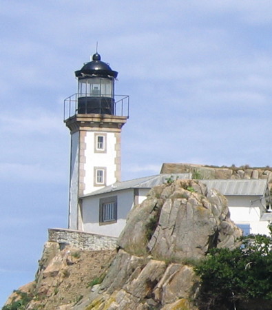
Pontusval Light, Brignogan-Plage, May 2009
Flickr Creative Commons photo by Larry Myhre

Mer Celtique Lighthouses

The Celtic Sea (Mer Celtique) includes the waters of the Atlantic northwest of Brittany, southwest of Cornwall, and south of Ireland.

Ploudalmézeau Lighthouse
Corn Carhai (Rochers de Portsall)
1901. Active; focal plane 20 m (66 ft); three white flashes every 12 s. 20 m (66 ft) octagonal reinforced concrete tower with gallery; the original lantern has been replaced by a much smaller modern lantern. Tower unpainted; lantern and gallery painted black. Trabas has Eckhard Meyer's closeup photo, Thomas Letournel also has a closeup, a distant photo is available, and Google has a satellite view. Located on waveswept rocks about 5 km (3 mi) northwest of Portsall in Ploudalmézeau. Accessible only by boat in very rough seas. Site and tower closed. ARLHS FRA-008; Admiralty A1836; NGA 7692.

Landéda (Aber Wrac'h) and Plouguerneau Lighthouses
Breac'h Ver
Date unknown. Active; focal plane 6 m (20 ft); two green flashes every 6 s. 6 m (20 ft) round stone tower, top painted green. Trabas has Capt. Peter's photo and Google has a satellite view. Located on the south side of the channel entering Aber Wrac'h. Accessible only by boat. Site open, tower closed. Admiralty A1832.
* La Palue (Aber Wrac'h) (feu antérieur)
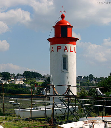
1847. Inactive since 1970 but maintained as a daybeacon. 9 m (30 ft) round masonry tower with lantern and gallery. Lighthouse painted white, lantern and gallery red. Werning's photo is at right (note the St. Antoine lighthouse in the background), a 2022 photo is available, Guyomard and Carceller have a photo by François Peleter, and Google has a street view and a satellite view. The front light of the range was replaced by a directional light on a concrete post (Admiralty A1831, NGA 7712). Located on the Quay de la Palue in Aber Wrac'h. Accessible by road, parking provided. Site open, tower closed. ARLHS FRA-784; ex-Admiralty A1831.
* Saint Antoine (feu postérieur)
1847. Inactive since 1970 but maintained as a daybeacon. 8 m (26 ft) round masonry tower with lantern and gallery. Lighthouse painted white, lantern and gallery red. Werning has a good photo, a 2022 closeup is available, and Google has a street view and a distant satellite view. This former rear lighthouse is maintained as a range daybeacon. Located about 400 m (1/4 mi) from the harbor in Aber Wrac'h. Site and tower closed (private property) but the lighthouse can be seen from the waterfront street. ARLHS FRA-785; ex-Admiralty A1831.1.
* Plouguerneau (feu postérieur) (1)
1845. Inactive since 1869. Square stone tower of the Église de St.-Pierre et St.-Paul. Guillaume Cingal has a closeup, Google has a street view, and Bing has a satellite view. The tower was built in 1701 although the rest of the church is more recent. This tower carried the rear light of the Aber Wrac'h entrance range until the Lanvaon lighthouse was built. Located in Plouguerneau. Site open, tower closed. ARLHS FRA-783.
** Lanvaon (Plouguerneau feu postérieur (2))
1869. Active; focal plane 55 m (180 ft); quick-flashing white light, intensified on and near the range line. 27 m (89 ft) 6-story square stone building with a peaked roof; the light is shown through a window on the top floor. Keeper's quarters were located in the tower. Building painted white with unpainted stone trim; on the side facing the range the peak of the building is painted with a large red triangular daymark. Werning has a good photo, Larry Myhre has another good photo, Trabas has a closeup by Capt. Peter, a closeup is available, and Google has a street view and a satellite view. When the range was established in 1845 the rear light was mounted on the church tower in Plouguerneau; this proved to be too far from the water to be clearly visible. A preservation group, l'Association Lanvaon, began working in 2015 to restore the lighthouse and open it to the public. By 2020 exterior and interior restoration was well underway, and by 2022 open house events were being held. Located off the D71 highway about 2.5 km (1.5 mi) west of Plouguerneau. Accessible by road, no parking provided. Site open, tower open for special events. Site manager: l'Association Lanvaon (Phare de Lanvaon). . ARLHS FRA-332; Admiralty A1826.1; NGA 7708.
La Palue Light
La Palue Light, Plouguerneau
photo copyright Malte Werning; used by permission
Île Wrac'h (Plouguerneau feu antérieur)
1845. Active; focal plane 20 m (66 ft); quick-flashing red light. 15 m (49 ft) square cylindrical stone tower with gallery, attached to the front of a 1-story stone keeper's house. The lantern was replaced by a short mast in 1973, when the lighthouse was automated and converted to wind power. Lighthouse painted white; gallery painted a brilliant orange as a daymark. Trabas has a closeup by Arno Siering, Philippe Guilhaumon has a 2023 photo, Werning has a photo, and Google has a satellite view. Located on an island on the north side of the entrance to L'Aber Wrac'h. There's a view from shore and it's possible, with caution, to walk to the lighthouse at low tide. Site and tower closed. . ARLHS FRA-065; Admiralty A1826; NGA 7704.

La Manche (English Channel) Lighthouses

Île Vierge Lighthouses
The International Hydrographic Organization defines the western limit of the English Channel to be the line joining Île Vierge in Brittany to Lands End in Cornwall. The 6 hectare (15 acre) islet of Île Vierge, site of a 15th century monastery, is administered as part of the commune of Plouguereau.

*
Île Vierge (1)
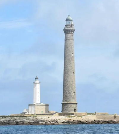
1845. Inactive since 1902. 31 m (102 ft) square cylindrical stone tower with lantern and gallery, rising from the center of a 2-story stone keeper's house. Lighthouse painted white; keeper's house is unpainted. Axel de Font-Réaulx's photo is at right, Antoine Klein has a closeup street view, and Google has a satellite view. This is a tall lighthouse but it proved to be not tall enough. Now it seems tiny compared to its mighty replacement. The old tower carries the station's fog horn (one 3 s blast every 60 s). The keeper's house continued in use until 2010. A two-year project, completed in 2021, renovated the lighthouse and restored the keeper's house, opening it as a lodge for overnight accommodations. Located on a small island about 1.5 km (1 mi) offshore at Lilia, northwest of Plouguerneau. Accessible only by boat. Site open April to September (tours available from Lilia), tower closed. ARLHS FRA-064.
**** Île Vierge (2)
1902 (station established 1845). Active; focal plane 77 m (253 ft); white flash every 5 s. 82.5 m (271 ft) round granite tower with lantern and gallery. The lighthouse is unpainted gray stone; lantern roof is weathered green. 1st order Fresnel lens. Axel de Font-Réaulx's photo is at right, Detienne has a page for the lighthouse, Larry Myhre has a good photo, Werning has a photo, Trabas has Capt. Peter's photo, Wikimedia has many photos, Marinas.com has aerial photos, and Google has a satellite view. This is the tallest traditional masonry lighthouse ever built and the tallest lighthouse in Europe, designed to be visible at a distance of 50 km (31 mi). There are 365 steps to reach the gallery, 400 in all to reach the lantern room. Construction began in 1897 and required five years. The centennial of the lighthouse was celebrated in July 2002. A masterpiece of French architecture, the building has an elegance rarely seen in lighthouses; Jacque Witt's photos convey something of the style of the structure. Gaston Pigeaud began work on the design in the 1880s, and the plan was completed and supervised by Armand Considère; the contractor was Gustave Corre. This was one of the last staffed light stations in France; the last keepers were withdrawn on 29 October 2010. Tours to the island, normally including access to the lighthouse, are arranged by the Écomusée de Plouguerneau. The lighthouse was closed in 2013 for interior restoration work; it reopened in July 2014. Accessible only by boat (it's possible to reach the islet on foot at low tide, but this is not recommended). Site and tower open to tours in July and August; inquire locally for times. . ARLHS FRA-038; Admiralty A1822; NGA 7716.

Île Vierge Lights, Plouguerneau, August 2023
Instagram photo by Axel de Font-Réaulx

Brignogan-Plage Lighthouse
* Pontusval (Pointe de Beg-Pol)
1869. Active; focal plane 16 m (52 ft); white or red light, depending on direction, occulting three times every 12 s. 15 m (49 ft) square cylindrical stone tower with lantern and gallery, attached to the front of a 1-story stone keeper's house. Lighthouse painted white, lantern and gallery black with a white roof. Larry Myhre's photo is at the top of this page, Guyomard and Carceller have photos, Werning has a fine photo, Trabas has a closeup by Capt. Peter, another photo is available, and Google has a street view and a satellite view. Detienne reports that the last keeper, Marie Paule, continues to reside in the lighthouse. Located on a point at the end of Route du Phare, about 2 km (1.2 mi) northwest of Brignogan-Plage. Parking provided. Site open, tower closed. . ARLHS FRA-404; Admiralty A1820; NGA 7720.

Sibiril Lighthouses
Moguériec (feu antérieur) (relocated from Honfleur)
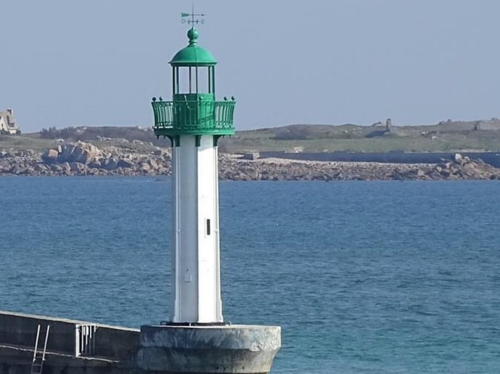
1861(?). Inactive since 2021. 10 m (33 ft) round cylindrical cast iron tower with lantern and gallery. Tower painted white, lantern and gallery green. A 2023 photo is at right, Arnaud Chapin has a 2020 street view Robert Nech has a photo, Detienne has a photo, and Google has a satellite view. This is a typical nineteenth century prefabricated tourelle. Originally built at Honfleur in Normandy, it was installed here in 1960. In 2015 the Bureau des Phares et Balises annnounced the lighthouse would be removed and a more modern light installed. Outraged villagers formed the Association Sauvons le Phare de Moguériec and fought for local ownership and restoration. A fund drive raised over €200,000 and eventually the authorities relented. The light was deactivated in 2021 and a leading light was placed on the rear tower.The old lighthouse was removed for restoration in 2022 and in 2023 it was reinstalled. NGA still lists both lights. Located at the end of the jetty in the harbor of Moguériec, a fishing port about 15 km (9 mi) southwest of Roscoff. The jetty is quite narrow but walkable with caution. Site open, tower closed. . ARLHS FRA-361; ex-Admiralty A1818; NGA 7724.
 

Front Light, Moguériec, September 2023
Instagram photo by lecomptoirdelafleurdefrance
Moguériec (feu postérieur)
Date unknown. Active; focal plane 22 m (72 ft); flash every 4 s, white, red or green depending on direction. 11 m (36 ft) concrete post attached to a square 1-story equipment shelter. Lighthouse painted white with a green top. Trabas has Capt. Peter's photo, Detienne has a photo, and Google has a satellite view. Located in farmland 440 m (1/4 mi) southwest of the front light. Site and tower closed (private property). ARLHS FRA-594; Admiralty A1818.1; NGA 7728.
 

Île de Batz and Roscoff Lighthouses
**** Île de Batz (2)
1836 (station established 1705). Active; focal plane 69 m (226 ft); four white flashes every 25 s; in addition a continuous red light is shown over a sector to the southwest. 43 m (141 ft) round stone tower with lantern and gallery, rising from the center of a 1-story stone keeper's house. Light station includes several assistant keeper's houses and other buildings. A photo is at the top of this page, Detienne has a page for the lighthouse, Pascal Méance has a nice photo, Trabas has Capt. Peter's photo, Gérald Vroonhove has a panoramic photo, Marinas.com has aerial photos, Eric Bluteau has the view from atop the tower, Arnaud Garmy has a closeup street view, and Google has a satellite view. The lighthouse, a sibling of the 1835 Penmarc'h light in Southern Finistère, replaced a 1705 stone tower from which open fires were displayed. The lantern was removed for restoration in 2019 and returned in 2022. The Île de Batz is an inhabited island about 5 km (3 mi) long, located about 2 km (1.2 mi) northwest of Roscoff. The island is accessible from Roscoff by ferry. Located on the heights in the western portion of the island. Site open; tower open daily in July and August, daily except Mondays in April, May, June and early September, and during the Easter, All Saints and Christmas holidays. . ARLHS FRA-071; Admiralty A1816; NGA 7732.
* Roscoff (feu postérieur)
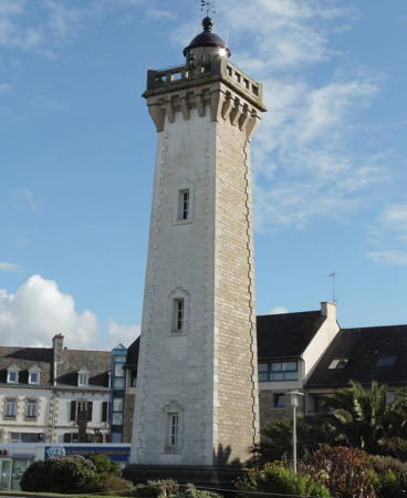
1917. Active; focal plane 24 m (79 ft); white light occulting three times, in a 2+1 pattern, every 12 s. 24 m (79 ft) square stone tower with castellated gallery and lantern. Seaward side of the tower painted white; lantern painted black. A photo is at right, DIRM has a page for the lighthouse, Werning has a great photo, Trabas has a fine photo by Arno Siering, Larry Myhre has a good photo, Pierre Cuzon has another photo, and Google has a street view and a satellite view. The front light is on a post. Roscoff is the terminal for ferries arriving from Plymouth, England and Cork, Ireland; a new deep-water port was built for them on the east side of the town. Located on the traditional waterfront in Roscoff. Site open; although formerly open on Thursday afternoons in July and August the tower was closed in 2023. Site manager: Phare de Roscoff . ARLHS FRA-461; Admiralty A1812.1; NGA 7752.
Ar Chaden
1912 (daybeacon built in 1865?). Active; focal plane 14 m (46 ft); six quick flashes followed by one long flash, white or red depending on direction, every 15 s. 22 m (72 ft) solid round stone tower with gallery and a small cylindrical equipment room; light mounted on a short mast. Upper half of tower painted yellow, lower half black (the opposite of the Men-Guen-Bras tower). Werning has a good photo, Trabas has a photo, Pierre Cuzon has a photo, and Google has a satellite view. Located northeast of Roscoff, marking a group of rocky islets obstructing the approach to the harbor. Accessible only by boat; visible distantly from shore. Site open, tower closed. ARLHS FRA-782; Admiralty A1808; NGA 7740.

Roscoff Light, Roscoff, February 2018
Instagram photo by mapafaros
Men-Guen-Bras
1914 (daybeacon built in 1865). Active; focal plane 14 m (46 ft); quick-flashing light, white, red, or green depending on direction. 20 m (66 ft) solid round stone tower with gallery and a small cylindrical equipment room; light mounted on a short mast. Upper half of tower painted black, lower half yellow. Werning has a fine photo, Trabas has a photo, and Google has a satellite view and a distant street view. Located on an islet about 500 m (0.3 mi) southeast of the Ar Chaden light and a short distance from shore. Accessible only by boat but it is possible to get a good view from shore. Site open, tower closed. ARLHS FRA-781; Admiralty A1810; NGA 7744.
Roscoff-Bloscon Jetée
Date unknown. Active; focal plane 9 m (30 ft); flash every 4 s, white or green depending on direction. 6 m (20 ft) post rising from a square 1-story equipment shelter. Upper half of the post painted green, lower half white. Trabas has a photo and Google has a street view and an indistinct satellite view. Ferries arrive in Roscoff daily from Plymouth, England, and twice a week from Cork in Ireland. The modern ferry port is on the east side of the city. Located at the end of the Roscoff ferry pier. Site status unknown. Admiralty A1805; NGA 7756.
Le Menk
Date unknown. Active; focal plane 6 m (20 ft); nine quick-flashing lights every 15 s, white or red depending on direction. 11 m (36 ft) mast atop a round stone tower. Upper portion of the tower painted yellow with a black horizontal band. Trabas has Capt. Peter's photo and Bing has a satellite view. Located on a reef about 1 km (0.6 mi) east of the Roscoff ferry terminal. Accessible only by boat. Site open, tower closed. Admiralty A1804; NGA 7758.

Carantec and Morlaix Lighthouses
Île Louët (feu antérieur)
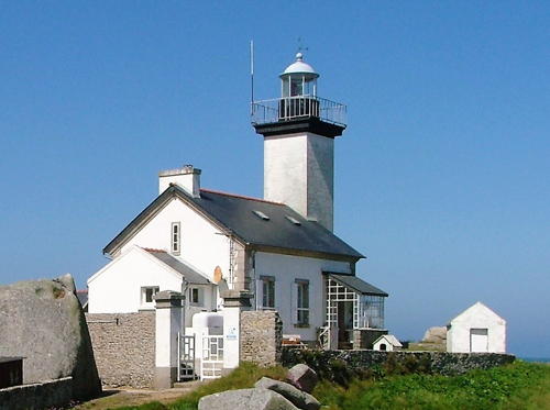
1860 (replaced a 1794 daybeacon). Active; focal plane 17 m (56 ft); white or green light, depending on direction, occulting three times every 12 s. 12 m (39 ft) square stone tower with lantern and gallery attached to a 1-story keeper's house. Lighthouse painted white with unpainted stone trim, lantern painted black. Additional 2-story keeper's house, built in 1910. A photo is at right, Werning has a photo, Trabas has a photo, Simon Tosser has a street view from the mainland, and Google has a satellite view. This lighthouse is the front light for the Grand Chenal, the main channel entering the Baie de Morlaix; the Phare de la Lande is the rear light. Located on a small island on the west side of the entrance to the Rade de Morlaix from the Baie de Morlaix. Accessible only by boat, but there should be good views from the mainland east of Carentec. Site and tower closed. ARLHS FRA-040; Admiralty A1800.1; NGA 7760.
* La Lande (feu postérieur)
1845 (replaced a 1775 daybeacon). Active; focal plane 85 m (279 ft); white flash every 5 s. 19 m (62 ft) square stone tower with lantern and gallery attached to the front of a 1-story stone keeper's house. Lighthouse painted white with unpainted stone trim, lantern painted black. Detienne has a page for the lighthouse, Trabas has a photo by Ronald Wöhrn, Werning has a good photo from a different angle, Roland Fischer has a 2022 photo, and Google has a street view and a satellite view. This lighthouse is the common rear light for the Chenal de Tréguier (the entrance range for the Rade de Morlaix) and also for the Grand Chenal of the Baie de Morlaix. Located on the southwest side of the Rade de Morlaix about 2 km (1.2 mi) northeast of Locquénolé. Accessible by road, no parking provided. Site open, tower closed. . ARLHS FRA-329; Admiralty A1800; NGA 7764.
Île Noire (feu antérieur)
1845 (replaced a 1775 daybeacon). Active; focal plane 15 m (49 ft); white, red, or green light, depending on direction, occulting twice every 6 s. 13 m (43 ft) square stone tower with castellated gallery attached to a 1-story stone keeper's house. Seaward side of the tower painted white; lantern is red. Trabas has Capt. Peter's photo, Yannick Le Cornec has a 2021 photo, Werning has a photo, Guyomard and Carceller also have photos, and Google has a satellite view. This is the front light of the entrance range for the Rade (Roads) de Morlaix; the Phare de la Lande is the rear light. The keeper's house was added in 1879 to expand the crowded quarters available within the tower. In 1973 the lighthouse was automated and converted to wind power. Located in the center of the entrance, which is about 2 km (1.2 mi) wide, between Térénez and Carentec. Accessible only by boat. Site and tower closed. ARLHS FRA-045; Admiralty A1799.9; NGA 7768.
Phare de l'Île Louët
Île Louët Light, August 2008
Wikimedia Creative Commons photo by Thesupermat

Information available on lost lighthouses:

Notable faux lighthouses:

Adjoining pages: East: Côtes d'Armor | South: Western Finistère

Return to the Lighthouse Directory index | Ratings key

Posted August 29, 2005. Checked and revised September 30, 2023. Lighthouses: 21. Site copyright 2023 Russ Rowlett and the University of North Carolina at Chapel Hill.