Lighthouses of France: Côtes d'Armor

France (officially the French Republic, République française) has coasts facing south on the Mediterranean Sea, west on the open Atlantic Ocean, and north on the English Channel (La Manche in French). Long a leader in lighthouse design, France has scores of famous and historic lighthouses. And it was a French engineer and physicist, Augustin-Jean Fresnel (1788-1837), who invented the powerful and beautiful lenses used in lighthouses around the world.

The old French province of Bretagne (Brittany) occupies a peninsula at the northwestern corner of France, separating La Manche (the English Channel from the Golfe de Gascogne (Bay of Biscay). Like Wales, Bretagne is an ancient Celtic country that maintained its independence until the end of the fifteenth century. Today it is divided into four départements of the French Republic. This page includes lighthouses of the department of Côtes d'Armor facing north on La Manche. Ar mor means "the sea" in Breton, so the name of the département means "coast of the sea."

The French word for a lighthouse, phare, is often reserved for the larger coastal lighthouses; a smaller light or harbor light is called a feu (literally "fire," but here meaning "light") or a balise (beacon). The front light of a range (alignement) is the feu antérieur and the rear light is the feu postérieur. In French île is an island, cap is a cape, pointe is a promontory or point of land, roche is a rock, récife is a reef, baie is a bay, estuaire is an estuary or inlet, détroit is a strait, rivière is a river, and havre is a harbor. The Breton word for a lighthouse is tour-tan; enez is an island, and men is a rock or reef.

Aids to navigation in France are maintained by the Bureau des Phares et Balises, an agency of the Direction des Affaires Maritimes (Directorate of Maritime Affairs). The Directorate has four regional offices (called Directions Interrégionale de la Mer, or DIRM) at Le Havre, Nantes, Bordeaux, and Marseille. Lights in Brittany are managed by the DIRM Nord-Atlantique - Manche Ouest (DIRM-NAMO) at Nantes.

ARLHS numbers are from the ARLHS World List of Lights. FR numbers are the French light list numbers, where known. Admiralty numbers are from volume A of the Admiralty List of Lights & Fog Signals. U.S. NGA List numbers are from Publication 114.

General Sources
Les Sentinelles des Mers - France - Bretagne
Photos and information posted by Guy Detienne.
Le Phare à travers le Monde
A large, well known site maintained by Alain Guyomard and Robert Carceller.
Lighthouses of Bretagne
Excellent photos by Marc de Kleijn.
Leuchttürme.net - Frankreich
Photos and notes by Malte Werning.
Lighthouses in Côtes-d'Armor
Photos available from Wikimedia.
France Lighthouses
Aerial photos posted by Marinas.com.
Online List of Lights - France North Coast
Photos by various photographers posted by Alexander Trabas. Many photos for France are by Capt. Peter Mosselberger ("Capt. Peter").
Phareland, le Site des Phares de France
This comprehensive site has good photos and information about the major lighthouses.
Société Nationale pour le Patrimoine des Phares et Balises (S.N.P.B.)
The French national lighthouse preservation organization.
Französische Leuchttürme
Historic photos and postcard images posted by Klaus Huelse.
GPSNavigationCharts
Navigation chart information for Côtes d'Armor.
Navionics Charts
Navigation chart for Côtes d'Armor.


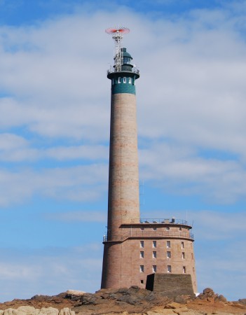
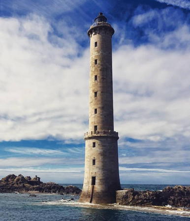
Grand Phare des Roches-Douvres, August 2008
Flickr Creative Commons photo by Clément Delafargue
Baie de Lannion Lighthouses
#Locquémeau Feu Antérieur
Date unknown. Inactive since 2019 and later removed. This was a 19 m (62 ft) square skeletal tower with gallery and an enclosed equipment shelter in the base. Lighthouse painted white. Detienne has a photo showing both range lights and Google has a good 2013 street view but Google's satellite view confirms the removal. The 1-1/2 story house seen behind the skeletal tower may be the former keeper's house. In 2019 the range was replaced by a leading light in the former rear lighthouse. Andreas Köhler visited in 2022 and reports that the tower was removed. Located on the Locquémeau waterfront on the south side of the entrance to the Lannion estuary 484 m (0.3 mi) northwest of the rear light. Site open, tower closed. ex-Admiralty A1794; NGA 7784.
* Locquémeau (ex-Feu Postérieur)
Date unknown. Active; quick-flashing light, white, red or green depending on direction. 6 m (20 ft) square tower with a peaked roof; the light is displayed from a small platform. Tower painted white; the small lantern is red. De Kleijn has a good photo, Trabas has Capt. Peter's closeup, Detienne has a photo, Google has a street view, and the light is centered in a Google satellite view. Located on a hillside in Trédoz-Locquémeau on the south side of the entrance to the Lannion estuary. Site open, tower closed. ARLHS FRA-770; Admiralty A1794 (ex-A1794.1); NGA 7788.
* Beg-Léguer (Beg-Léger, Bec-Léquer, Lannion)
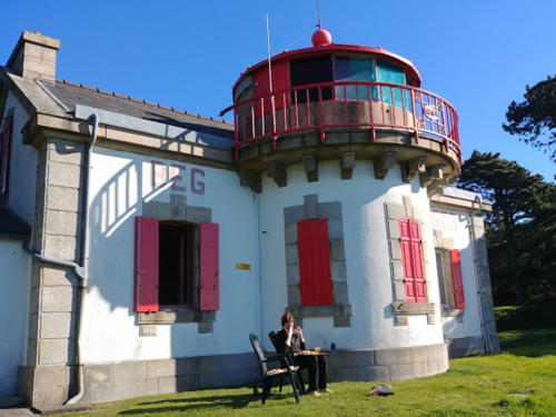
1884. Active; focal plane 60 m (197 ft); white, red, or green light, depending on direction, occulting four times every 12 s. 8 m (26 ft) semicircular cylindrical stone tower attached to the front face of a 1-story stone keeper's house. The house is painted white with red trim; the large lantern, which apparently doubled as an observation room, is painted red. François LeStof has the photo at right and a photo of the light in action, Trabas has a closeup by Ronald Wöhrn, de Kleijn has an excellent photo, Guyomard and Carceller have photos by Benoît le Goff and Christian Asencio, Huelse has a historic postcard view, and Google has a satellite view. This lighthouse is a sibling of the Pointe du Millier light on the Pointe du Raz in Southern Finistère. Located on the north side of the entrance to the Lannion (also called Léger) estuary, about 8 km (5 mi) southeast of Trébeurden. Site open, tower closed (the entrance is marked privé, private, but there doesn't seem to be any real obstacle to viewing the lighthouse). . ARLHS FRA-193; Admiralty A1792; NGA 7780.

Beg-Léguer Light, Lannion, February 2019
Google Maps photo by François LeStof

Perros-Guirec Lighthouses
Triagoz
1864 (Dujardin et Pelau). Active; focal plane 31 m (102 ft); red or white light, depending on direction, occulting twice every 6 s. 30 m (98 ft) square pink granite tower with castellated gallery, incorporating keeper's quarters, rising from a large square stone base. The lantern was removed in 1981, when the lighthouse was converted to wind power and automated operation; this original lantern is on display in Lézardrieux (see below). Trabas has a photo, Karim Senoun has a 2021 photo, a closeup photo is available, a historic photo shows the lighthouse with its lantern, Wikipedia has an 1871 plan, and Bing has a satellite view. The light marks the entrance to the Baie de Lannion. Located on a waveswept rock, la Roche de Guen-Bras, about 9 km (5.5 mi) offshore northwest of Trégastel. Accessible only by boat in rough seas. Site and tower closed. . ARLHS FRA-062; FR-0589; Admiralty A1790; NGA 7792.
* Sept-Îles (Île aux Moines) (3)
1952 (station established 1835). Active; focal plane 59 m (194 ft); three white flashes every 15 s. 20 m (66 ft) semicircular cylindrical stone tower with lantern and gallery attached to modern 2-story keeper's house. Tower unpainted, lantern painted black. Trabas has a good photo, Johan Gallet has a 2022 photo, a 2007 photo is available, Wikimedia has a distant view, Marinas.com has aerial photos, and Google has a satellite view. This lighthouse replaced a light station destroyed by German troops in September 1944; Huelse has a historic postcard view of the prewar lighthouse. One of the last staffed French lighthouses, this light was destaffed in 2007. It has been powered by the wind since 1957. The Sept-Îles (Seven Islands), a group of islets about 5 km (3 mi) north of Ploumanac'h, have been protected as a bird sanctuary since 1912. Located on l'Île aux Moines, one of the highest of the islets. Accessible only by boat; tours available from Trégastel. Site open, tower closed. . ARLHS FRA-042; FR-0588; Admiralty A1786; NGA 7796.
* Men-Ruz (Méan-Ruz, Ploumanac'h) (2)
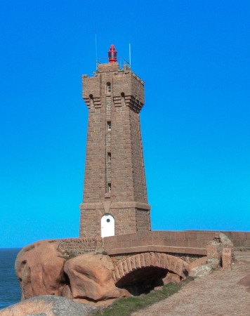
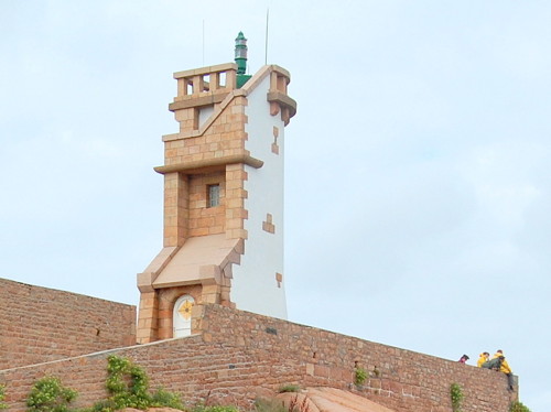
1948 (station established 1860). Active; focal plane 26 m (85 ft); red or white light, depending on direction, occulting once every 4 s. 15 m (49 ft) medieval-style square pink granite tower with castellated gallery and a small lantern. Tower unpainted, lantern painted red. Isabelle Puaut's photo is at right, Trabas has Capt. Peter's closeup, de Kleijn has a closeup, the Phareland site has many photos, Wikimedia has numerous photos, Huelse has a postcard photo, and Google has a satellite view. Huelse also has a historic postcard view of the original lighthouse, a square cylindrical stone tower attached to a 1-1/2 story keeper's house. That lighthouse was destroyed during World War II, and the replacement was designed by architects Auffret et Odorico. Located on a rocky promontory at the northeastern entrance to the harbor of Ploumanac'h. Site open, tower closed. . ARLHS FRA-351; Admiralty A1784; NGA 7800.
Phare de Mean-Ruz
Mean-Ruz Light, Ploumanac'h, March 2009
Flickr Creative Commons photo by Isabelle Puaut

Saint-Quay-Perros and Louannec Lighthouses
* La Colombier (Passe de l'Est Feu Antérieur) (1)
1860. Inactive. 7 m (23 ft) 1-story stone keeper's house, painted white; the light was displayed through a circular window at the seaward end of the house. Trabas has Capt. Peter's closeup photo, a 2021 photo shows the house being repainted, and Google has a satellite view. De Kleijn's 2008 photo shows that the active light (focal plane 28 m (92 ft); white light, intensified on and near the range line, occulting four times every 12 s) has been moved to a small skeletal tower in front of the house. Below the lighthouse is a much older stone dovecote (colombier) that served as a day range mark until the lighthouse was built. Located above the waterfront in Saint-Quay-Perros. Site open, tower closed. ARLHS FRA-244. Active light: Admiralty A1774; NGA 7808.
* Kerprigent (Passe de l'Est Feu Postérieur)
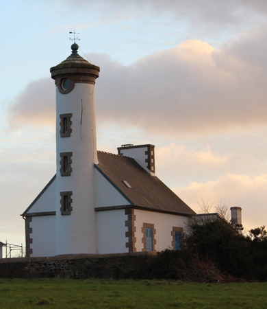
1860. Active; focal plane 79 m (259 ft); quick-flashing white light, intensified on and near the range line. 14 m (46 ft) round cylindrical stone tower with a conical roof, attached to 1-story stone keeper's house; the light is displayed through a window. Tower painted white. A photo is at right, Trabas has Capt. Peter's closeup photo, Hervé Charreyre has a photo, Guyomard and Carceller have several good photos, and Google has a satellite view and a closeup street view. Sibling of the Kerjean lighthouse. Behind the lighthouse is an old stone mill tower that served as a day range mark until the lighthouse was built. Located off the Chemin de Kerprigent, west of Saint-Méen, 2.9 km (1.8 mi) southwest of the Colombier light. Site open, tower closed. ARLHS FRA-769; Admiralty A1774.1; NGA 7812.
* Nantouar (Passe de l'Ouest Feu Antérieur)
1860. Inactive since 1976. Approx. 10 m (33 ft) cylindrical round stone tower with a conical roof, attached to 1-story stone keeper's house; the light was displayed through a window. Tower painted white. Jacques Bruylands has an excellent 2005 photo, de Kleijn has a photo, Marinas.com has aerial photos, and Google has a street view and a satellite view. The lighthouse was deactivated when the rear light (next entry) was converted to a directional light. The building was sold at auction in 1994. Endangered by beach erosion, it is protected by a seawall and extensive riprap. Located on the coast east of Louannec. Site open, tower closed. Owner/site manager: private. . ARLHS FRA-368.
* Kerjean (Passe de l'Ouest Feu Postérieur)
1860. Active; focal plane 78 m (256 ft); white, red, or green light, depending on direction, occulting three times, in a 2+1 pattern, every 12 s. 16 m (52 ft) round stone tower with a conical roof, attached to 1-story stone keeper's house; the light is displayed through a window. Tower painted white; upper portion of the tower painted black on the seaward side. Trabas has a closeup, de Kleijn has a photo, and Google has a street view and a satellite view. Originally the rear light of a range, this lighthouse was converted to a directional light in 1976. Located on the Route de Kerjean about 1 km (0.6 mi) southeast of the Nantouar lighthouse. Site and tower closed, but the lighthouse can be seen from the nearby road. ARLHS FRA-326; Admiralty A1770; NGA 7820.

Kerprigent Light, Louannec, February 2012
Wikimedia Creative Commons photo by Creasy

Prévenan, Tréguier, and Pleubian Lighthouses
* Port-Blanc (Voleur)
1858 (not lit until 1889). Active; focal plane 17 m (56 ft); flash every 4 s, white, red, or green, depending on direction. 12 m (39 ft) round stone tower with a domed top, painted white; the light is displayed through a window midway on the tower. Trabas has Capt. Peter's closeup photo and Google has a satellite view and an indistinct street view. This tower was built as a daybeacon in 1858. By tradition the tower is called La tourelle du Voleur (Thief's Tower) because area residents were angered that a proper lighthouse, planned in 1882, was never built. Located in Port-Blanc, the port district of Penvénan. Site open, tower closed. ARLHS FRA-407; Admiralty A1768; NGA 7824.
La Corne
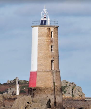
1876. Active; focal plane 14 m (46 ft); three flashes every 12 s, white, red, or green, depending on direction. Approx. 18 m (60 ft) round stone tower, upper half cylindrical and lower half conical, incorporating keeper's quarters, with gallery but no lantern. The north (seaward) face of the tower is painted white on the upper portion and red on the lower. Jerome Gautier's photo is at right, Trabas has Capt. Peter's photo, de Kleijn has a photo, Kevin Lajoie has a drone view, and Google has a satellite view. This tower originally had one more floor and a conical roof; it was patched up in a truncated state after its top was destroyed during World War II. Located in the northeastern entrance to Jaudy or Tréguier estuary. Some photos suggest that at low tide it is possible to walk fairly close to the tower. Accessible only by boat. Site open, tower closed. ARLHS FRA-250; Admiralty A1760; NGA 7832.
* Port-la-Chaîne (Grande Passe Feu Antérieur)
1863. Active; focal plane 12 m (39 ft); white, red or green light, depending on direction, occulting once every 4 s,. 5 m (16 ft) 1-1/2 story stone keeper's house; the light is displayed from a small platform in front of a dormer window on the second floor. The front of the house is painted white, the dormer red. De Kleijn has a photo, Trabas has an excellent closeup, Andreas Köhler has a closeup photo, Guyomard and Carceller have a good photo by Benoît le Goff, and Google has a satellite view. This range guided ships into Port-la-Chaîne, a small port at the eastern entrance to the Jaudy or Tréguier estuary. In 2021 the range was discontinued and a modern leading light, seen in a 2022 photo, was mounted in front of the dormer window. The house is reported to be available for rental. Located in the village of Port-la-Chaîne, about 1.5 km (5 mi) north of Pleubian. Site open, tower closed. ARLHS FRA-425; Admiralty A1762; NGA 7836.

La Corne Light, Pleubian, January 2021
Google Maps photo by Jerome Gautier
* Saint-Antoine (Grande Passe Feu Postérieur) (2)
1949 (station established 1863). Inactive since 2021. 6 m (20 ft) stone tower, with the light displayed through what seems to be a dormer window of a keeper's house. De Kleijn has a closeup photo, Andreas Köhler has a closeup photo, Trabas has a photo, and Google has a satellite view. From the sea, this light looks like the original lighthouse, which was very similar to the front light at Port-la-Chaîne, but as J.C. Fichou writes, there is pas de bâtiment derrière--no house behind the false front wall. Wall painted white; the false dormer at the top of the tower is painted red. The light was deactivated in 2021 when the front light becae a leading light. Located in Pleubian 1.4 km (0.9 mi) southeast of the front light. Site open, tower closed. ARLHS FRA-472; ex-Admiralty A1762.1; NGA 7840.

Les Héaux Lighthouse
Les Héaux de Bréhat
1840 (largely rebuilt after World War II) (Léonce Reynaud). Active; focal plane 48 m (157 ft); white, red, or green light, depending on direction, occulting three times every 12 s. 57 m (187 ft) round stone tower with lantern and gallery. Tower unpainted, lantern painted black. A photo is at right, Pierrette Cornic has a 2012 photo, a good 2007 photo and a 2017 closeup are available, Trabas has Capt. Peter's photo, Wikimedia has distant views, and Google has a satellite view. One of the tallest French lighthouses; building it on such an exposed site was a major engineering accomplishment in the 1830s. German troops attempted to destroy it during World War II and succeeded in decapitating about 15 m (50 ft) of the tower. The tower was rebuilt and raised in height after the war, returning to service in 1950. The lighthouse stands off the northernmost point of Brittany and guides ships bound for the Tréguier estuary to the west or the Trieux estuary to the east. Located on a rocky, waveswept ledge about 6 km (4 mi) north of Larmor-Pleubian. Accessible only by boat in rough seas; distantly visible from the shore. Site and tower closed. . ARLHS FRA-021; FR-0576; Admiralty A1738; NGA 7844.

Lézardrieux (Trieux Estuary) Lighthouses
Men Grenn
1896. Inactive since 2015 but still listed by NGA. 10 m (33 ft) round stone tower painted yellow with a black horizontal band. Trabas has a photo, another photo is available, and Google has a satellite view. The light was deactivated despite strenuous local opposition; officials said it is now too far from the open channel to be useful. Located on a shoal off the west side of the entrance to the Trieux estuary. Accessible only by boat. Site open, tower closed. ARLHS FRA-456; ex-Admiralty A1746; NGA 7872.

Héaux de Bréhat Light, Pleubian, December 2017
Instagram photo by breton_et_fier_finistere_29
* Bodic (Trieux Feu Postérieur) (2)
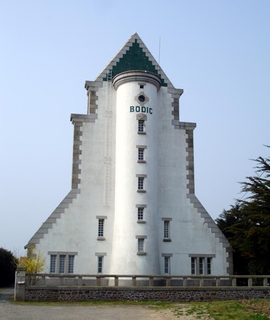
1949 (station established 1867). Active; focal plane 55 m (180 ft); quick-flashing white light. Remarkable in appearance, this is a 23 m (75 ft) semicircular cylindrical stone tower flanked and surmounted by a huge stone wall daymark that presents the tower to approaching mariners as a gigantic arrow. At the rear, the lighthouse is attached to a 1-1/2 story stone keeper's house, which is occupied by a resident keeper. Wall and tower painted white with unpainted stone trim; the triangle at the point of the arrow is green. The rear of the lighthouse is painted red with white trim. A 2009 photo is at right, Trabas has a great photo by Arno Siering, de Kleijn has a fine closeup, Wikimedia has numerous photos including a photo of the rear of the lighthouse, Huelse has a postcard view, and Google has a street view and a satellite view. The lighthouse is the rear light of a range, with the Phare de la Croix (see below) as the front light. Like other lighthouses in the area the original lighthouse was destroyed during World War II. Located at the end of the Route de Bodic, on the west side of the Trieux estuary near Kermouster, 3.8 km (2.4 mi) southwest of the front light. Site open, tower closed. . ARLHS FRA-200; FR-0571; Admiralty A1748.1; NGA 7880.
* Coat Mer Aval (Feu Antérieur) (2)
Around 1949 (station established 1869). Active; focal plane 16 m (52 ft); continuous red or green light, depending on direction. 11 m (36 ft) square stone tower with a peaked roof; the light is displayed from a small platform near the top. Sides of the tower are painted white, but the front is unpainted. Marc de Kleijn has a closeup photo, Trabas has Capt. Peter's closeup, and the lighthouse is centered in a Google satellite view. This is the second range for ships entering the Trieux estuary. The original lighthouse, destroyed during World War II, was a small keeper's house with the light displayed from a window; the present tower has no house but was designed to present a similar appearance to approaching ships. Located on the Pointe de Coat Mer, on the west side of the Trieux estuary about 2.5 km (1.5 mi) north of Lézardrieux. Site open, tower closed. ARLHS FRA-242; Admiralty A1752; NGA 7892.
* Coat Mer Amont (Feu Postérieur) (2)
Around 1949 (station established 1869). Active; focal plane 50 m (164 ft); continuous red light. 8 m (26 ft) square stone tower with a peaked roof; the light is displayed through a small window near the top. The front of the tower is painted white. Patrice Barre has a closeup photo, De Kleijn also has a closeup photo, Trabas has a Capt. Peter's closeup, and Google has a street view and a satellite view. The original lighthouse, destroyed during World War II, was a small keeper's house with the light displayed from a window; the present tower has no house but was designed to present a similar appearance to approaching ships. Located in the Pointe de Coat Mer, on the west side of the Trieux estuary, 660 m (0.4 mi) south southwest of the front light and about 2.0 km (1.2 mi) north of Lézardrieux. Site open, tower closed. ARLHS FRA-854; Admiralty A1752.1; NGA 7896.
Feu de Bodic
Bodic Light, Lézardrieux, April 2007
Wikimedia Creative Commons photo by Clicsouris
* Les Perdrix
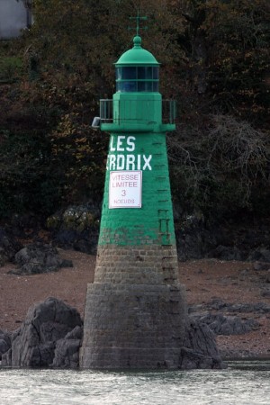
1869. Active; focal plane 5 m (16 ft); two flashes every 6 s, white along the channel and green in other directions. 11 m (36 ft) round stone tower with lantern and gallery, painted green. De Kleijn's photo at right, Trabas has a photo, Detienne has a photo, and Google has a satellite view. This was the only Trieux lighthouse to escape damage during World War II. Located in the Trieux estuary at Lézardrieux. The light marks a narrow passage in the Trieux estuary. Accessible only by boat, but easily viewed from shore. Site open, tower closed. ARLHS FRA-588; Admiralty A1758; NGA 7900.
* [Triagoz (lantern)]
1864. Inactive since 1981. The original lantern and drum-style Fresnel lens of the Phare de Triagoz (see above) are on display at the entrance to the Parc des Phares et Balises, the former lighthouse depot grounds, in Lézardrieux. Google has a street view and a satellite view. Site open.

Île de Bréhat Area Lighthouses

The Île de Bréhat is actually two small islands, joined at low tide, lying just off the coast at Paimpol. The islands have a permanent population of about 400 and are a popular destination for same-day outings.

Roche Quinonec
1884. Active; focal plane 12 m (39 ft); continuous light, white, red or green depending on direction. 6 m (20 ft) unpainted round cylindrical tower. Trabas has Capt. Peter's photo, Andreas Köhler has a 2022 closeup, and Detienne also has a closeup, but the small tower is hard to spot in Google's satellite view. This light guides vessels westbound in the Chenal de Ferlas, the passage on the south side of the Île de Bréhat. Located on a rock at Ioguivy de la Mer on the south side of the channel. It is possible to walk to the lighthouse at low tide. Site open, tower closed. Admiralty A1745; NGA 7884.
Men-Joliguet
1884. Active; focal plane 10 m (33 ft); two flashes every 6 s, white, red or green depending on direction. 8 m (26 ft) round stone tower painted yellow with a black horizontal band. Trabas has a photo by Ronald Wöhrn, Lightphotos.net has a good closeup photo, Detienne has a photo, the lighthouse is on the right in Christophe Geneste's photo, and Google has a satellite view. This light guides vessels in the Chenal de Ferlas. Located on a rock just off the south side of the island. Accessible only by boat. Site open, tower closed. ARLHS FRA-354; Admiralty A1744; NGA 7868.
La Croix (Trieux Feu Antérieur) (2)
1867. Active; focal plane 15 m (49 ft); white light occulting once every 4 s. 18 m (59 ft) round cylindrical stone tower with a castellated gallery but no lantern. The front face of the tower is painted white; gallery is red; rear face unpainted. Jean-Jacques Beauval has a photo, Guyomard and Carceller have photos by Laure Chappuis, Trabas has a photo, Wikimedia has numerous photos, and Google has a satellite view. The top half of the tower was destroyed during World War II and restored on the original plan after the war. (Note: There is another Feu de la Croix at Concarneau in southern Finistère.) Located on a waveswept rock off the entrance to the Rivière de Trieux. Accessible only by boat. Site and tower closed. ARLHS FRA-025; Admiralty A1748; NGA 7876.

Les Perdrix Light, Lézardrieux, November 2008
photo copyright Marc de Kleijn; used by permission
* Rosédo (2)
1948 (station established 1860). Active; focal plane 29 m (95 ft); white flash every 5 s. 13 m (43 ft) semicircular cylindrical stone block tower with gallery but no lantern, attached to a 1-1/2 story stone keeper's house. The front of the tower is painted white with unpainted pink stone trim. Keeper's house occupied by a resident caretaker. Trabas has an excellent closeup by Arno Siering, a 2017 closeup is available, Jacqueline Lemée has a photo taken from the rear, and Google has a satellite view. As in the case of so many lighthouses in this region, the original lighthouse was destroyed during World War II. A prominent sémaphore (signal station) is located about 800 m (1/2 mi) west of the lighthouse and is sometimes mistaken for the light. Located at the northwest point of the Île de Bréhat, which is accessible by ferry from L'Arcouest. Site open, tower closed. . ARLHS FRA-463; FR-0569; Admiralty A1742; NGA 7864.
Le Paon (Île de Bréhat) (2)
1947 (station established 1860). Active; focal plane 22 m (72 ft); continuous light, white, red, or green depending on direction. 12 m (40 ft) semicircular cylindrical stone block tower with gallery but no lantern. The front of the tower is painted white with unpainted pink stone trim. A 2008 photo is at right, Guyomard and Carceller have many photos by Marc Impens, Trabas has a photo by Ronald Wöhrn, Wikimedia has several photos, a view from the sea is available, Huelse has a postcard view, Jean-Michel Pinon Bruand has a street view, and Google has a satellite view. The original lighthouse, a square stone tower attached to a 1-1/2 story keeper's house, was destroyed during World War II. The replacement tower is built on the original stone foundation. Located on a rocky promontory at the northeast point of the Île de Bréhat. Site open, tower closed. . ARLHS FRA-382; Admiralty A1740; NGA 7860.
La Horaine
1897. Active; focal plane 13m (43 ft); three white flashes every 12 s. 20 m (66 ft) octagonal concrete tower with lantern and gallery, painted with black bands. A photo (second photo on the page) and a distant view are available but tower is not seen in Google's satellite view. A historic photo is available. According to J.C. Fichou there were at least seven earlier but unsuccessful efforts to place a beacon on this dangerous rock; none lasted through the first serious storm. Located on a rock about 5.5 km (3.5 mi) east northeast of the Île de Bréhat. Accessible only by boat in generally rough seas. ARLHS FRA-316; Admiralty A1726; NGA 7856.
Barnouic
1910. Active; focal plane 15 m (49 ft); three very quick white flashes every 5 s. 19 m (62 ft) octgonal concrete tower painted black with one yellow horizontal band. A photo (1/3 the way down the page) is available and Trabas has a distant view by Kees Aalbersberg but the lighthouse is not seen in Google's satellite view. Located on a rocky shoal about 22 km (12 mi) northeast of the Île de Bréhat. Accessible only by boat in generally rough seas. ARLHS FRA-181; Admiralty A1730; NGA 7852.
Le Paon Light
Le Paon Light, Île de Bréhat, August 2008
Wikimedia Creative Commons photo
by J. Pline

Roches-Douvres Lighthouse
Roches-Douvres (2)
1954 (station established 1868). Active; focal plane 60 m (197 ft); white flash every 5 s. 65 m (213 ft) round stone tower rising from a 5-story elliptical stone keeper's quarters. Lighthouse unpainted, lantern painted black. Clément Delafargue's photo is at the top of this page, Trabas has a photo by Kees Aalbersberg, Wikimedia has Graham Rabbitts's view from the sea, and Gabriel Bouruet Aubertot has a view from the sea, but the reef is not seen in Google's satellite view. The Roches-Douvres are rocks forming a very dangerous reef in La Manche (English Channel); the rocks are completely covered at high tide but exposed at low tide. The original lighthouse here was a 58 m (190 ft) cast iron tower, one of the tallest such towers ever built. Tapering to a mere 4 m (13 ft) in diameter at the top, the lighthouse swayed alarmingly in storms, but it stood until it was destroyed during World War II. After the war it took six years to build the present massive stone lighthouse. This lighthouse is farther from the mainland than any other waveswept European lighthouse. Located about 30 km (19 mi) off the French coast and about 42 km (26 mi) west of Jersey in the Channel Islands. Accessible only by boat in very rough seas. Site and tower closed. . ARLHS FRA-457; FR-0558; Admiralty A1734; NGA 7848.

Paimpol and Plouézec Lighthouses
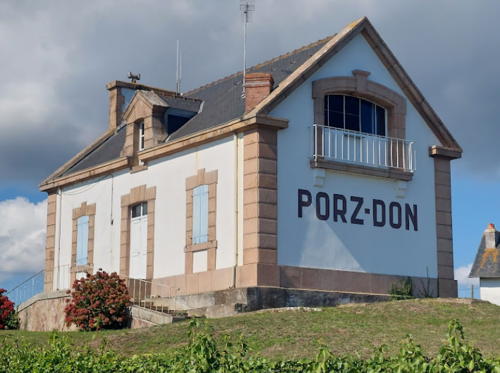
* Pointe de Porz-Don (Paimpol)
1880. Active; focal plane 13 m (43 ft); red or white light, occulting twice every 6 s; white light is shown only along the preferred approach direction from due east. 8 m (26 ft) 1-1/2 story stone keeper's house, the light being displayed through an upstairs window at one end of the house. Guyomard and Carceller have an excellent photo by Denis Wagner has the 2022 photo at right, Benoît le Goff, de Kleijn has a good photo, Trabas has Capt. Peter's closeup photo, another photo is available, and Google has a satellite view. The house is occupied. Located on the north side of the entrance to Paimpol, about 1.5 km (1 mi) southeast of Ploubazlenac. Site open, tower closed. ARLHS FRA-441; Admiralty A1722; NGA 7904.
 

Pointe de Porz-Don Light, Paimpol, September 2022
Google Maps photo
by Denis Wagner
 
Lost-Pic (L'Ost-Pic)
1894. Active; focal plane 20 m (66 ft); white or red light, depending on direction, occulting once every 4 s. 15 m (49 ft) square stone tower with gallery, incorporating 3-story keeper's quarters; the light is displayed from a short mast. Lighthouse painted white with gray trim, mast painted red. Guyomard and Carceller have photos by Laure Chappuis, de Kleijn has a very good photo, Trabas has a photo, Wikimedia has distant views, Huelse has a historic postcard photo, and Google has a satellite view. This lighthouse is perched on a rock at the eastern entrance of the Baie de Paimpol. The tower was damaged and the lantern destroyed during World War II but the lighthouse was repaired by 1948. Located about 7.5 km (4.5 mi) east of Paimpol but only 1.5 km (1 mi) off the coast northeast of Plouézec. Accessible only by boat, but there should be good views from shore. Site and tower closed. . ARLHS FRA-039; Admiralty A1720; NGA 7916.

Saint-Quay-Portrieux and Binic Lighthouses
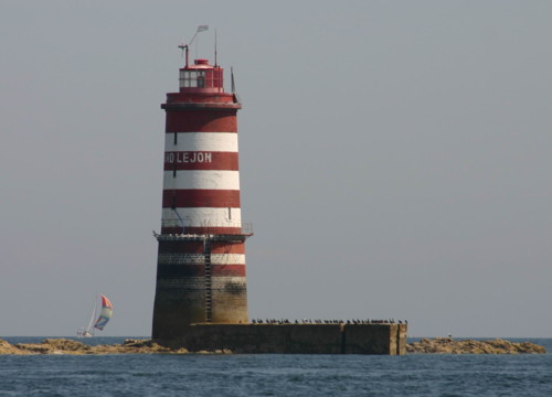
Le Grand Léjon (2)
1881 (station established 1862). Active; focal plane 17 m (56 ft); five white flashes every 20 s; red flashes are shown over sectors to the southeast and southwest. 25 m (82 ft) round stone tower, with lantern and gallery, painted with red and white horizontal bands, originally incorporating keeper's quarters. Karl Blohm's photo is at right, Trabas has the very distant view from shore and Huelse has a historic postcard view but the lighthouse is not seen in Google's satellite view. This waveswept lighthouse guards the entrance to the Baie de Saint-Brieuc. Located on an isolated rock 16.5 km (10 mi) northeast of St.-Quay-Portrieux. Accessible only by boat. Site and tower closed. ARLHS FRA-018; FR-0550; Admiralty A1716; NGA 7920.
Le Grand Léjon Light
Le Grand Léjon Light, La Manche, August 2005
Wikimedia Creative Commons photo
by Karl Blohm
Île Harbour (Îles Saint-Quay)
1850. Active; focal plane 16 m (52 ft); white, red, or green light depending on direction, occulting twice every 6 s. 13 m (43 ft) square cylindrical masonry tower rising from the front of a 2-story masonry keeper's house. Lantern removed; the light is displayed from a short mast atop the watch room. House and tower painted white with gray trim, watch room and mast painted red. Werning has a good photo, Jean-Marc le-Campion has a 2018 view from the sea, Guyomard and Carceller have a distant photo by Laure Chappuis, Trabas Capt. Peter's closeup photo, Huelse has a historic postcard view, and Google has a satellite view. The Îles de Saint-Quay are a group of rocky islets blocking direct access to Saint-Quay-Portrieux. Located on the northwesternmost of the islands about 2 km (1.25 mi) northeast of the harbor of St.-Quay-Portrieux. Accessible only by boat, but there are good views from shore. Site and tower closed. ARLHS FRA-020; Admiralty A1714; NGA 7924.
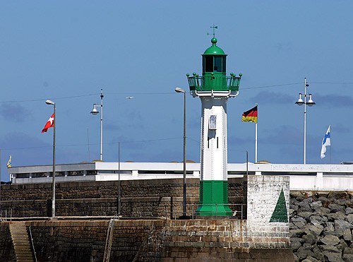
* Saint-Quay-Portrieux (2)
1867 (Gustave Eiffel). Station established 1853. Active; focal plane 11.5 m (35 ft); green flash every 2.5 s. 12 m (39 ft) octagonal round cylindrical cast iron tower with lantern and gallery. Tower painted white, lantern and gallery green. Werning's photo is at right, Guyomard and Carceller have a photo by Sophie Muzerelle, Trabas has Capt. Peter's excellent photo, Jean Michel Daoudal has a nice closeup, Detienne has a photo, and Google has a distant street view and a satellite view. This historic little lighthouse is a prototypical tourelle, similar to hundreds of small cast iron lighthouses built in France for installation throughout the country and around the world. Designed by Gustave Eiffel for ease of assembly and relocation, it was exhibited at the Exposition Universelle de Paris in 1867. It was relocated in 1879, when the mole was extended. Located at the end of the north mole at Saint-Quay-Portrieux, at the northwestern corner of the Baie de St.-Brieuc. Accessible by walking the mole. Site open, tower closed. ARLHS FRA-500; Admiralty A1712; NGA 7928.
Phare de Saint-Quay-Portrieux
Saint-Quay-Portrieux Light, Saint-Quay-Portrieux
photo copyright Malte Werning; used by permission
Herflux
Date unknown. Active; focal plane 10 m (33 ft) round cylindrical concrete tower, currently painted white. Two flashes every 6 s, white, red or green depending on direction. Trabas has Capt. Peter's photo and Google has a satellite view. The light guides vessels in the entrance channel of the Baie de St.-Brieuc. Located on a rocky islet about 1.2 km (3/4 mi) east of Saint-Quay-Portrieux. Accessible only by boat, but there are good views from shore. Site and tower closed. Admiralty A1714.5.
* Binic (Môle de Penthièvre)
1853. Active; focal plane 12 m (39 ft); white light occulting three times every 12 s. 12 m (39 ft) round stone tower with lantern and gallery. North side of the tower painted with a long white bar, south side unpainted; lantern painted green. Werning has a fine photo, Trabas has Capt. Peter's closeup photo, Guyomard and Carceller have a photo by Benoît le Goff, Detienne has a photo, Huelse has a historic postcard view, C. Klopfer has a street view, and Google has a satellite view. Located at the end of the mole in Binic, about 13 km (8 mi) northwest of Saint-Brieuc. Accessible by walking the mole. Site open, tower closed. . ARLHS FRA-198; Admiralty A1710; NGA 7936.

Saint-Brieuc, Pléneuf-Val-André, and Erquy Lighthouses
* Le Légué (Pointe-à-l'Aigle, St.-Laurent-de-la-Mer)
1857. Active; focal plane 13 m (43 ft); very quick-flashing green light. 12 m (39 ft) round stone tower with lantern and gallery. North side of the tower painted white, south side unpainted; lantern painted green. Werning has a good photo, Trabas has Capt. Peter's photo, Detienne has a photo, Guyomard and Carceller have a photo by Benoît le Goff, and Google has a street view and a satellite view. This lighthouse is located off the Rue du Phare in Le Légué, on the end of a short, narrow jetty at the west side of the entrance to the river Gouët, which leads to Saint-Brieuc. It isn't clear if the jetty is open (it may be too narrow to walk safely), but the light can easily be viewed from shore. Tower closed. . ARLHS FRA-484; Admiralty A1708; NGA 7940.
Le Rohein
Date unknown. Active; focal plane 13 m (43 ft); nine quick flashes every 15 s, white, red or green depending on direction. Approx. 8 m (26 ft) round cylindrical tower painted yellow with one black horizontal band. Trabas has a view from the sea and Bing has a satellite view. NGA lists the tower height as 15 m (49 ft), but this is clearly an error. Located on a rocky islet in the entrance to the Baie de Saint-Brieuc. Accessible only by boat. Site open, tower closed. ARLHS FRA-458; Admiralty A1703; NGA 7952.
Dahouët (La Petite Muette)
1896 (tower built 1886). Active; focal plane 10 m (33 ft); flash every 4 s, white, red, or green depending on direction. 17 m (56 ft) round cylindrical stone tower on a broadly conical base, painted white with one green horizontal band. Lantern removed. Trabas has Capt. Peter's photo, Guyomard and Carceller have good photos by Guy le Péchon, Wikimedia has a photo, a 2022 photo is available, Detienne has a photo, Huelse has a historic postcard view, and Google has a street view and a satellite view. The stone tower was built in 1886 and used as a daybeacon until the light was added ten years later. Located in the entrance to the harbor of Dahouët in Pléneuf-Val-André, about 20 km (13 mi) northeast of St.-Brieuc. Accessible only by boat. Site open, tower closed. ARLHS FRA-392; Admiralty A1704; NGA 7948.
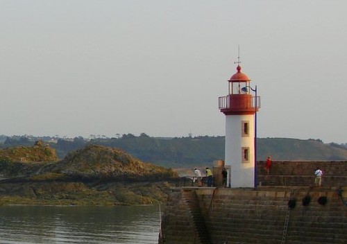
* Erquy Jetée Intérieur
1896. Active; focal plane 10 m (33 ft); red flash every 2.5 s. 10 m (33 ft) round stone tower with lantern and gallery. Tower painted white, lantern and gallery red. Roar Pettersen's photo is at right, a 2007 closeup is available, Guyomard and Carceller have a photo by Benoît le Goff, Trabas has Capt. Peter's photo, Detienne has a photo, Pin Doty has a 2023 photo, Huelse has a historic postcard view, Loïc Kergoat has a closeup street view, and Google has a satellite view. Located at the end of the inner jetty at Erquy, on the east side of the Baie de Saint-Brieuc. Accessible by walking the jetty. Site open, tower closed. . ARLHS FRA-273; Admiralty A1702; NGA 7956.

Erquy Jetée Intérieur Light, Erquy, June 2006
Flickr Creative Commons photo by Roar Pettersen

Plévenon (Cap Fréhel) Lighthouses
* Cap Fréhel (2)
1702 (Siméon Garangeau) (station established 1650). Inactive 1847-1945 and since 1950. Approx. 15 m (49 ft) round stone tower with gallery and watch room; lantern removed. De Kleijn has a fine photo, another closeup is available, Francisco Jose Puentes Iglesias has a 2022 closeup, and Alain Paterne's photo of both Cap Fréhel lighthouses appears at right. The tower is a sibling of the famous Phare du Stiff on the Île d'Ouessant in Northern Finistère. The original lighthouse was a round masonry tower about 15 m (49 ft) tall. The Marquis de Vauban, Louis XIV's chief engineer, visited the station in 1694 and ordered a new, fortified tower to be built. Accordingly, the robust tower includes quarters for the keepers and for a small force of soldiers. Following World War II a temporary light was mounted atop this venerable tower while the new lighthouse was under construction. The Phare de Cap Fréhel is the traditional landfall light for Saint-Malo. Located on the cape, about 7 km (4 mi) northeast of Plévenon. Site open, tower closed. ARLHS FRA-228.
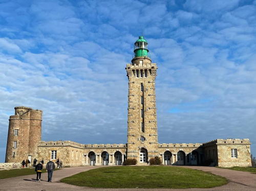
**** Cap Fréhel (4)
1950 (station established about 1650). Active; focal plane 85 m (279 ft); two white flashes every 10 s. 33 m (108 ft) square stone tower with castellated stone gallary, topped by a circular watchroom, lantern, and a second gallery, attached to a U-shaped stone keeper's house. Alain Paterne's photo of both Cap Fréhel lighthouses is at right, Maurizio Agelli has a good photo, Trabas has a closeup photo by Tom Chisholm, Wikimedia has a portfolio of photos, Marinas.com has aerial photos, and Google has a street view and a satellite view. This grand lighthouse replaced the 1847 lighthouse, an octagonal stone tower attached to a 2-story keeper's house; Huelse has a postcard view. The 1847 lighthouse was destroyed by German troops in World War II. Yves Hémar's design for the present lighthouse reflects the historical significance and continuing importance of this light station, which has guided returning French ships for more than 350 years. Resident caretaker on site. Located on the cape, about 7 km (4 mi) northeast of Pléhéral-Plage-Vieux-Bourg. Site open, tower open daily during the summer; group tours by appointment at other times. Site manager: Phare du Cap Fréhel . ARLHS FRA-085; FR-0547; Admiralty A1698; NGA 7960.

Cap Fréhel Light, Plévenon, October 2023
Instagram photo by Alain Paterne

Information available on lost lighthouses:

Notable faux lighthouses:

Adjoining pages: North: Jersey | East: Ille-et-Vilaine | West: Northern Finistère

Return to the Lighthouse Directory index | Ratings key

Posted July 29, 2005. Checked and revised October 8, 2023. Lighthouses: 41. Site copyright 2023 Russ Rowlett and the University of North Carolina at Chapel Hill.