Lighthouses of France: Languedoc-Roussillon (Occitanie)

France (officially the French Republic, République française) has coasts facing south on the Mediterranean Sea, west on the open Atlantic Ocean, and north on the English Channel (La Manche in French). Long a leader in lighthouse design, France has scores of famous and historic lighthouses. And it was a French engineer and physicist, Augustin-Jean Fresnel (1788-1837), who invented the powerful and beautiful lenses used in lighthouses around the world.

For local government mainland France is divided into 94 departments (départements), which are grouped for administrative purposes into 12 regions (régions). This page includes lighthouses of the southernmost part of mainland France in the former region of Languedoc-Roussillon. The coast of this region includes the four départements of Gard, Hérault, Aude, and Pyrénées-Orientales. The first three departments fall within the historic province of Languedoc, so-called because its inhabitants spoke (and many still speak) the Occitan language (langue d'oc), which is related to Catalan. Pyrénées-Orientales corresponds roughly to the former province of Roussillon, which was part of the principality of Catalonia until it was captured by France in 1659. Here Catalan itself is often spoken. In 2016 the region of Languedoc-Roussillon was merged with Midi-Pyrénées to form a larger region called Occitanie (Occitania in English).

The coast of Languedoc-Roussillon faces east or southeast on the Golfe du Lion, a broad bight of the Mediterranean Sea. The coast is mountainous in the south, where the Pyrenees mountains come down to the sea, but it is a relatively low coast elsewhere, with few major ports. (The gulf acquired its name in the Middle Ages for reasons not understood, since there are no lions in France. In Roman times it was called the Gallic Bay, Sinus Gallicus.)

The French word for a lighthouse, phare, is often reserved for the larger coastal lighthouses; a smaller light or harbor light is called a feu (literally "fire," but here meaning "light") or a balise (beacon). The front light of a range (alignement) is the feu antérieur and the rear light is the feu postérieur. In French île is an island, cap is a cape, pointe is a promontory or point of land, roche is a rock, récife is a reef, baie is a bay, estuaire is an estuary or inlet, détroit is a strait, rivière is a river, and havre is a harbor. A lighthouse is called a far in both Occitan and Catalan. In Catalan illa is an island, capa is a cape, punt is a promontory or point of land, roca is a rock, badia is a bay, riu is a river, and port is a harbor.

Aids to navigation in France are maintained by the Bureau des Phares et Balises, an agency of the Direction des Affaires Maritimes (Directorate of Maritime Affairs). The Directorate has four regional offices called Directions Interrégionale de la Mer, or DIRM, at Le Havre, Nantes, Bordeaux, and Marseille. Mediterranean lighthouses fall under the Marseille office, DIRM Méditerranée.

ARLHS numbers are from the ARLHS World List of Lights. FR numbers, where available, are the French light list numbers. Admiralty numbers are from volume E of the Admiralty List of Lights & Fog Signals. U.S. NGA List numbers are from Publication 113.


Pointe de l'Espiguette Light, Grau-du-Roi, Gard, February 2024
Instagram photo by coolhand776178
General Sources
Les Sentinelles des Mers - Méditerranée
Photos and information posted by Guy Detienne.
DIRM Méditerranée - Phares de Méditérranée (Continental Ouest)
An interactive map leads to information and photos for the major lighthouses.
Le Phare à travers le Monde
A large, well known site, rich in fine photos, maintained by Alain Guyomard and Robert Carceller.
Phareland, le Site des Phares de France
This comprehensive site has good photos and information about the major lighthouses.
Online List of Lights - France - South Coast
Photos by various photographers posted by Alexander Trabas. Many photos for this coast are by Capt. Peter Mosselberger ("Capt. Peter").
Lighthouses in Occitanie
Photos by various photographers available from Wikimedia.
World of Lighthouses - South Coast of France
Photos by various photographers available from Lightphotos.net.
Leuchttürme in Frankreich
Photos by Andreas Köhler.
France Lighthouses
Aerial photos posted by Marinas.com.
Société Nationale pour le Patrimoine des Phares et Balises (S.N.P.B.)
The French national lighthouse preservation organization.
Französische Leuchttürme
Historic photos and postcard images posted by Klaus Huelse.
GPSNauticalCharts
Navigational chart information for the south of France.
Navionics Charts
Navigational chart for the south of France.


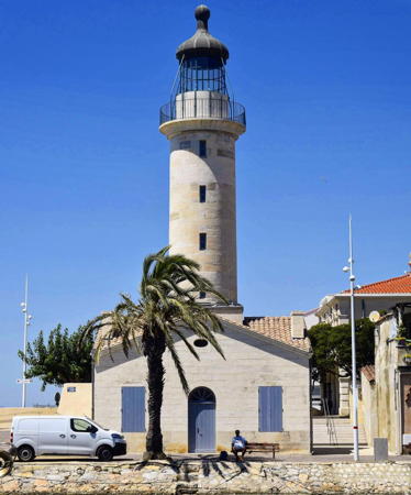
Cap Leucate Light, Leucate, Aude, February 2024
Instagram photo by Nicolas Kristofiles

Lighthouses of Gard

Grau-du-Roi and Aigues-Mortes Lighthouses
In Occitan a grau is an inlet or pass connecting the sea to a lagoon or inland waterway. In this case, grau-du-roi or the "king's channel" refers to the canal ordered by King Louis IX in the 13th century to make Aigues-Mortes a seaport.
* L'Espiguette
1869 (Charles Dupuy). Active; focal plane 27 m (89 ft); three white flashes every 15 s. 27 m (89 ft) square masonry tower with lantern and gallery, attached to a 1-story masonry keeper's house. Upper third of the lighthouse painted black, lower 2/3 white. A 2024 photo is at the top of this page, Rudolf Sedlaczek has a 2018 photo, DIRM has a page for the lighthouse, Trabas has Capt. Peter's photo, a closeup 2023 photo is available, Marinas.com has aerial photos, French Wikipedia has an article on the lighthouse, and Google has a satellite view and a distant street view. The Pointe de l'Espiguette is a broad, sandy barrier, the southwestern extension of the Camargue (the Rhône delta). Sediment from the Rhône is accumulating here; the lighthouse was built 150 m (165 yd) from the sea but now it is a full kilometer (0.6 mi) from the surf. The lighthouse was restored in a major project in 2020-22 and was to be opened to the public in the summer of 2022. Located at the end of the Route de l'Espiguette about 6 km (4 mi) southeast of Grau-du-Roi. Site open, tower closed. . ARLHS FRA-276; FR-1321; Admiralty E0586; NGA 6320.
* Aigues-Mortes (Tour de Constance)
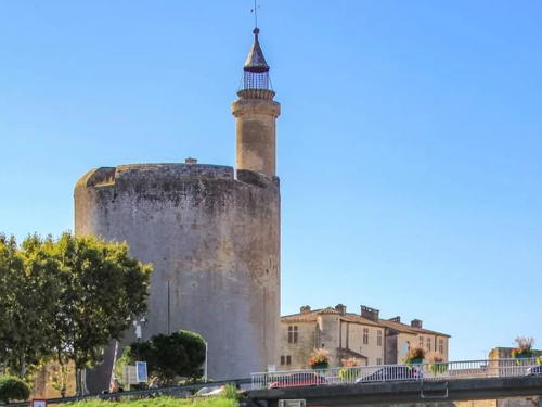
1246. Inactive for many centuries. 33 m (108 ft) round cylindrical masonry tower with lantern and gallery, mounted on one side of a large cylindrical donjon (keep). A 2022 photo by Bertrand Barbier is at right, Wikimedia has Ingo Mehling's photo, and Google has a street view and a good satellite view. King Louis IX (St. Louis) had the Tour de Constance built in 1242 and established a light on it in 1246, before he departed on the Seventh Crusade in 1248. He also had a canal dredged to make Aigues-Mortes a seaport. After the crusades the canal silted up and the tower ceased to show a light. Located in Aigues-Mortes, a historic port town now 6 km (3.75 mi) northeast of Grau-du-Roi and the sea. Site open, tower closed. Site manager: Centre des Monuments Nationaux. . ARLHS FRA-512.
* Port Camargue Jetée de l'Ouest
Date unknown (station established 1872). Active; focal plane 9 m (30 ft); three green flashes every 15 s. 7 m (23 ft) post attached to a triangular 1-story equipment room. Lighthouse painted white; the light is green. Trabas has Capt. Peter's photo and Google has a satellite view. Located at the end of the west jetty at Port Camargue, about 2.5 km (1.5 mi) south of Grau-du-Roi. Site open, tower closed. Admiralty E0583.2; NGA 6296.

Tour de Constance, Aigues-Mortes, October 2022
Instagram photo by Bertrand Barbier
* Port Camargue Jetée de l'Est
Date unknown (station established 1873). Active; focal plane 8 m (26 ft); red flash every 4 s. 6 m (20 ft) post attached to a triangular 1-story equipment room. Lighthouse painted white; the light is red. Trabas has Capt. Peter's photo, Guyomard and Carceller have photos (click on either right arrow; the metal tower shown on this page is apparently a faux lighthouse), and Google has a satellite view. Located at the end of the east jetty at Port Camargue, about 2.5 km (1.5 mi) south of Grau-du-Roi. Site open, tower closed. Admiralty E0583.4; NGA 6300.
* Grau-du-Roi Jetée de l'Est (2)
Date unknown (station established 1873). Active; focal plane 10 m (33 ft); three green flashes every 15 s. 9 m (30 ft) metal post light rising from a triangular 1-story equipment room. Lighthouse painted white; the light is green. Trabas has a closeup photo and Google has a street view and a satellite view. This light replaced a cast iron tourelle shown in Huelse's postcard view. These jetty lights mark the entrance to the Chenal Maritime leading to Aigues-Mortes. Located at the end of the west jetty at Grau-du-Roi. Site open, tower closed. ARLHS FRA-308; Admiralty E0582; NGA 6284.
* Grau-du-Roi Jetée de l'Ouest (3)
Date unknown (station established 1858). Active; focal plane 10 m (33 ft); red light occulting twice every 6 s. 9 m (30 ft) metal post rising from a triangular 1-story equipment room. Lighthouse painted white; the light is red. A closeup photo is available, Trabas has a closeup by Heike and Friedrich Klett, and Google has a street view and a satellite view. This light replaced a cast iron tourelle (1872) shown in Huelse's postcard view. Located at the end of the west jetty at Grau-du-Roi. Accessible by walking the pier. Site open, tower closed. ARLHS FRA-309; Admiralty E0582.2; NGA 6288.
* Grau-du-Roi
1829. Inactive since 1869. 19 m (62 ft) round cylindrical stone tower with lantern and gallery, centered on a 1-story keeper's house. Lighthouse painted white. The tower is floodlit at night. Louise Béguinot's 2022 photo is at right, a nice 2008 photo is available, Guyomard and Carceller have two good photos, a 2021 photo is available, Wikimedia has several photos, and Google has a street view and a satellite view. Grau-du-Roi is a small port on the west side of the Camargue (the Rhône delta); the Chenal Maritime leads northeast to the older port town of Aigues-Mortes. This lighthouse was replaced in 1869 by the Phare de l'Espiguette, but the old tower has been carefully preserved. Located at the base of the west jetty of the canal entrance in Grau-du-Roi. Site open, tower closed. . ARLHS FRA-307.

Grau-du-Roi Light, Grau-du-Roi, August 2022
Instagram photo by Louise Béguinot

Lighthouses of Hérault

La Grande Motte, Mauguio, and Palavaz-les-Flots Lighthouses
These are lights of popular beachfront resorts north of Sète. The Canal du Rhône à Sète provides an intracoastal waterway parallel to the sea behind these resorts.

* La Grande Motte Jetée Est
Date unknown. Active; focal plane 8 m (26 ft); green flash every 4 s. 6 m (20 ft) round tower rising from a triangular 1-story equipment shelter. Lighthouse painted white with green trim. Trabas has Capt. Peter's photo, another closeup is available, and Google has a satellite view. Located on the east breakwater at La Grande Motte. Accessible by walking the pier. Site open, tower closed. Admiralty E0580.2.
La Grande Motte Jetée Ouest
Date unknown. Active; focal plane 12 m (39 ft); two red flashes every 6 s. 12 m (39 ft) two wing-like white concrete walls joined at the base by a small equipment shelter. Trabas has Capt. Peter's photo, Quentin Leyrat has a photo, and Google has a satellite view. The effect of the walls is to make the light appear much larger at a distance. Located at the end of the west breakwater at La Grande Motte. Accessible only by boat. Site open, tower closed. ARLHS FRA-704; Admiralty E0580; NGA 6276.
* Carnon-Plage Jetée Est
Date unknown. Active; focal plane 9 m (30 ft); green flash every 4 s. 6 m (20 ft) round tower rising from a triangular 1-story equipment shelter. Lighthouse painted white with green trim. Trabas has a photo by Heike and Friedrich Klett, a 2023 photo is available, and Google has a satellite view and a distant street view of the two jetty lights. Located on the east (really north) breakwater at Carnon-Plage. Accessible by walking the pier. Site open, tower closed. Admiralty E0578.2; NGA 6280.
* Carnon-Plage Jetée Sud-Ouest
Date unknown. Active; focal plane 9 m (30 ft); four red flashes every 15 s. 6 m (20 ft) round tower rising from a triangular 1-story equipment shelter. Lighthouse painted white with red trim. Trabas has a photo by Heike and Friedrich Klett, Ludger Baumann has a 2022 closeup, and Google has a satellite view and a distant street view of the two jetty lights. This marina also has a canal connection to the Canal du Rhône à Sète. Located on the south breakwater at Carnon-Plage. Accessible by walking the pier. Site open, tower closed. ARLHS FRA-700; Admiralty E0578; NGA 6272.
* Le Lez (Palavaz-les-Flots)
Date unknown. Active; focal plane 8 m (26 ft); green flash every 2.5 s. 6 m (20 ft) post rising from a triangular 1-story equipment shelter. Lighthouse painted white with dark green band at the top. Eric Barraut's photo is at right, Trabas has Capt. Peter's closeup photo, Julien Mounik has a street view, and Google has a satellite view. A sculpture of four figures called L'Espoir (Hope) stands next to the lighthouse. This light marks the entrance to the Lez River, which is canalized in its lower course; the river channel leads to Palavas-les-Flots and connects to the intracoastal Canal du Rhône à Sète. Located on the north side of the river/canal entrance. Site open, tower closed. Admiralty E0577.5; NGA 6270.

L'Espoir sculpture and Le Lez Light, Palavas-les-Flots, April 2019
Google Maps photo by Eric Barraut

Frontignan Lighthouse
Frontignan Digue Est
Date unknown. Active; focal plane 15 m (49 ft); three green flashes every 12 s. 8 m (26 ft) concrete tripod tower. Entire lighthouse is white. Trabas has Capt. Peter's photo and Google has a satellite view and a distant street view. The light appears to be a smaller version of the Épi Dellon light (next entry). Located at the end of the east breakwater of Frontignan, a town on the east side of Sète. Accessible only by boat. Site and tower closed. Admiralty E0557.2; NGA 6216.

Sète Lighthouses
Sète is a port and seaside resort town with a permanent population of about 45,000.

Sète Épi Dellon Extrémité Est (2?)
Date unknown. Active; focal plane 20 m (66 ft); red light, 2 s on, 2 s off. 15 m (49 ft) concrete tripod tower. Entire lighthouse is white. Trabas has a photo, Hervé Therry has a photo, and Google has a good satellite view. NGA formerly listed the tower height as only 7 m (23 ft), probably referring to an earlier light. The Sète Epi Dellon breakwater has a long eastward extension, and this light is located at the extreme east end of the breakwater. Accessible only by boat. Site and tower closed. Admiralty E0547.5; NGA 6200.
Sète Épi Dellon
1896. Active; focal plane 21 m (69 ft); two red flashes every 6 s. 19 m (62 ft) round masonry tower with lantern and gallery. Lighthouse painted white, lantern and gallery red. Trabas has a photo, Vitalii Markov has a 2020 photo, Phareland.com has a photo of the Môle St.-Louis light showing the outer breakwater as well; the 1869 Brise-Lame light appears on the right end of the breakwater and the Épi Dellon light in the center. Google has a good satellite view. Located at the center of the breakwater's southeastern extension. Accessible only by boat (the outer breakwater does not connect to shore). Site and tower closed. Admiralty E0547; NGA 6196.
Sète Brise-Lames (Outer Breakwater)
1869. Active; focal plane 15 m (49 ft); three red flashes every 12 s. 8 m (26 ft) round cast iron tourelle with lantern and gallery. Tower painted white; lantern and gallery painted red. Trabas has a photo by Capt. Peter Mosselberger, Michel Lancien has a photo, Constantine Manolagas has a photo, and Google has a satellite view. When it was built this lighthouse marked the north end of the outer breakwater. By the 1890s the breakwater had been extended eastward, so the lighthouse now stands in the elbow where this newer section joins the original. Accessible only by boat (the outer breakwater does not connect to shore). Site and tower closed. Admiralty E0550; NGA 6192.
Sète Nouvelle Digue (South Jetty)
Date unknown. Active; focal plane 10 m (33 ft); red occulting once every 4 s. 7 m (23 ft) round tower rising from a triangular 1-story equipment shelter. Lighthouse painted white with red trim. Trabas has a photo, Hervé Therry has a photo, and Google has a satellite view and a distant street view. Located at the end of a rubblestone breakwater extending southward off the Môle St.-Louis. Accessible only by boat; this mole is not walkable. Admiralty E0552; NGA 6184.
*** Sète Môle Saint-Louis (6)
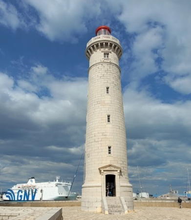
1948 (station established 1684). Active; focal plane 34 m (112 ft); four flashes every 15 s, white or red depending on direction. 31 m (101 ft) round masonry tower with lantern and gallery. Tower painted white; lantern painted red. Jean-Claude Becqueriaux has the 2024 photo seen at rght, a 2017 photo is avilable, Wikimedia has a 2011 photo, Trabas has Arno Siering's closeup, Huelse has a historic postcard view, and Google has a street view and a good satellite view. The port of Sète was built in the late 1600s as the Mediterranean entrance of the Canal du Midi. The Môle Saint Louis is the historic breakwater mole sheltering the port and the canal entrance; today there is also an outer breakwater to the southeast. The original tower was rebuilt a few years later when the mole was extended. The third lighthouse (1720) was rebuilt in 1771 and was the first French lighthouse with a glass-enclosed lantern. It served until a 30 m (98 ft) tall lighthouse, seen in another postcard view, was built in 1861. The 1861 lighthouse was destroyed during World War II and the present lighthouse is a copy. Located at the end of the mole. Site open, tower typically open on weekends in May and June and daily in July and August, but the schedule varies; check the website. . ARLHS FRA-486; FR-1301; Admiralty E0546; NGA 6180.

Môle St.-Louis Light, Sète, April 2024
Google Maps photo by Jean-Claude Becqueriaux
* Sète (Mont St. Clair)
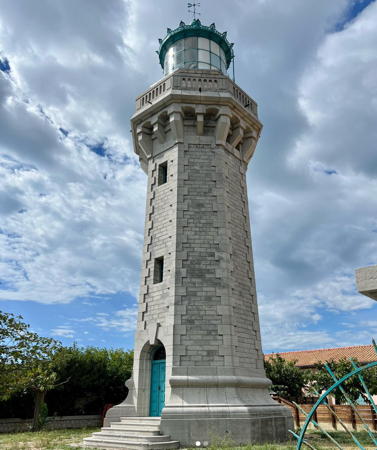
1903. Active; focal plane 93 m (305 ft); white flash every 5 s. 23 m (75 ft) octagonal masonry tower with lantern and gallery. Tower painted white; lantern painted dark green. Rotating 1st order Fresnel lens. A magnificent turn of the 20th century tower. Keeper's houses and other station buildings also survive. Friedrich Klett's 2022 photo is at right, Wikimedia has Christian Ferrer's photo, DIRM has a page for the lighthouse, Trabas has a closeup photo, Magali Matteucci has a 2022 photo, another good photo is available, Elise Glenaz has a 2023 photo, and Google has a street view and a fine satellite view. Located off the Chemin du Phare, on the slope of Mont Saint Clair, to the west of the harbor entrance and just below the sailors' cemetery. Site open, tower closed. . ARLHS FRA-362; FR-1300; Admiralty E0544; NGA 6164.
* Canal de Sète Entrance East Side (Pointe Courte)
Date unknown. Active; focal plane 8 m (26 ft); quick-flashing green light. 7 m (23 ft) post rising from a triangular 1-story concrete equipment room. Lighthouse painted white with green trim at the top. Trabas has a closeup photo, Murariu Adrian has a view from the bay, and Google has a street view and a satellite view. The Canal de Sète is a historic channel connecting the Étang de Thau to the sea through Sète. Located at the end of the Quai du Mistral, marking the east side of the entrance to the canal from the lagoon. Site open, tower closed. Admiralty E0560; NGA 6236.
* Canal de Sète Entrance West Side
Date unknown. Active; focal plane 8 m (26 ft); quick-flashing red light. 7 m (23 ft) post rising from a triangular 1-story concrete equipment room. Lighthouse painted white with red trim at the top. Trabas has a closeup photo, another photo is available, and Google has a street view and a satellite view. Located at the end of the Quai de la Daurade, marking the west side of the entrance to the canal from the lagoon. Site open, tower closed. Admiralty E0561; NGA 6240.
Pointe du Barrou
Date unknown. Active; focal plane 6 m (20 ft); quick-flashing white light. 6 m (20 ft) round stone tower; lower half painted yellow, upper half black. Trabas has Capt. Peter's photo, Nelly Peyre has a 2022 photo, and Google has a satellite view. Located on a shoal in the Étang de Thau on the approach from the lagoon to Sète. Accessible only by boat. Site open, tower closed. Admiralty E0561.5; NGA 6241.

Mont-St.-Clair Light, Sète, September 2022
Instagram photo by Friedrich Klett

Marseillan (Étang de Thau) Lighthouses
The Étang de Thau is the largest of a series of lagoons along the coast of Languedoc. The lagoon is about 21 km (13 mi) long and 8 km (5 mi) wide. The Canal du Rhône à Sète connects the Étang de Thau to Marseille through the chain of lagoons. Built in the late 1600s, the Canal du Midi provides a water connection between the Mediterranean and the Garonne, which flows into the Atlantic below Bordeaux.
* Marseillan Jetée Nord-Est
Date unknown. Active; focal plane 7 m (23 ft); green light, 2 s on, 2 s off. 6 m (20 ft) round tower rising from a triangular 1-story equipment shelter. Lighthouse painted white with green trim. Trabas has Capt. Peter's photo, a 2018 photo is available, and Google has a street view and a satellite view. Located on the north side of the entrance to the harbor of Marseillan from the Étang de Thau. Site open, tower closed. ARLHS FRA-707; Admiralty E0567.2.
* Marseillan Jetée Sud-Ouest
Date unknown. Inactive. 6 m (20 ft) round tower rising from a triangular 1-story equipment shelter. Lighthouse painted white with red trim. Google has a street view and a satellite view. Located on the south side of the entrance to the harbor of Marseillan from the Étang de Thau. Site open, tower closed.
* Les Onglous (Canal du Midi)
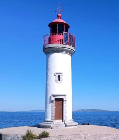
1902. Active; focal plane 10 m (33 ft); white or red light depending on direction, occulting twice every 6 s. 11 m (36 ft) round cylindrical masonry tower with lantern and gallery. Tower painted white, lantern and gallery rail red. A 2023 photo is at right, Trabas has Capt. Peter's photo, Aurelien Chauchat has a photo, Wikimedia has several photos, and Google has a street view and a satellite view. This lighthouse stands on a short jetty projecting into the Étang de Thau. It marks the entrance from the lagoon into the Canal du Midi. Located on the east jetty at the canal entrance, about 1.5 km (1 mi) south of Marseillan. Site open, tower closed. . ARLHS FRA-376; Admiralty E0568.
#Marseillan-Plage Digue Ouest (1)
Date unknown. Active; focal plane 7 m (23 ft); red flash every 4 s. This was a 5 m (17 ft) post rising from a 1-story concrete equipment room. Lighthouse painted white with green trim at the top. Google has a 2009 street view. However, Trabas has Capt. Peter's photo showing that the light has been replaced by a light on a simple post. Google's satellite view also shows the new light. The marina at Marseillan-Plage is also the start of a canal for small craft leading to the south end of the Étang de Thau. Located at the end of the west (really north) breakwater at Marseillan-Plage, northeast of Cap d'Agde. Accessible only by boat. Site open, tower closed. ARLHS FRA-706. Current light: Admiralty E0542.1.

Les Onglous Light, Marseillan, September 2023
Instagram photo by Haflokast

Agde Lighthouses
Fort Brescou (1)
1836. Inactive since 1901. 9 m (30 ft) round stone tower, unpainted; lantern removed. Qsl.net has a closeup photo, the tower can be seen rising from the center of the fort in Guyomard and Carceller's photo by Guy Guyonnet, Marinas.com has aerial photos, and Google has a satellite view. The Île de Brescou is a fortified island in the Mediterranean off Cap d'Agde; built for defense, the fort was later used for many years as a prison. Guided tours were stopped in 2005 because of the deteriorated condition of the fort. A support group, Amis de Brescou, has formed to work for its restoration. Located about 1.5 km (1 mi) south of the point of Cap d'Agde. Accessible only by boat. Site and tower closed. ARLHS FRA-702.
Fort Brescou (2)
1901 (station established 1836). Active; focal plane 22 m (72 ft); two flashes every 6 s, white or red depending on direction. 14 m (46 ft) round masonry tower with lantern and gallery mounted on a round concrete base. Tower painted white, lantern and gallery red. Wouter Huizinga's photo is at right, Trabas has Capt. Peter's photo, Nicolai Folbert has another good photo, David Reverchon has a photo, Theo Lassarat has a distant street view from the Agde Jetée de l'Est, and Google has a satellite view. Located at the southern (seaward) corner of the fort. Accessible only by boat. Site and tower closed. ARLHS FRA-015; Admiralty E0538; NGA 6136.
* Cap d'Agde (Mont St.-Loup)
1836. Inactive since 1903. Square masonry tower with lantern and gallery, rising from a large fortification. The building is a former French Navy signal station. Nico Gavignet has a 2017 photo, Brian Oliver has a photo, Huelse has a historic postcard view, and Google has a street view and a good satellite view. Guyomard and Carceller also have a photo of an older tower, the 1750 Tour des Anglais, but it is not clear that this tower was used as a lighthouse. The lighthouse was built in connection with improvement of the Canal du Midi, which made Agde a major port. In 1903, with Agde in decline, the light was moved to Mont St.-Clair in Sète and the lighthouse became a signal station; the lantern was replaced with a square observation room. The building was restored in 1988 but closed in 2000; it seems now to be abandoned. Located at an elevation of 113 m (370 ft) on the summit of Mont Saint-Loup (Volcan d'Agde) an extinct volcano rising on the southeast side of the town of Agde, about 2.5 km (1.5 mi) from the coast; the mountain is protected as a nature reserve. Site open, tower status unknown. ARLHS FRA-708.
La Lauze
Date unknown. Active; focal plane 10 m (33 ft); green flash every 4 s. 10 m (33 ft) post mounted on a conical concrete base. Upper half of the lighthouse painted green, lower half white. Trabas has Capt. Peter's photo and Google has a satellite view. Located about 250 m (820 ft) southeast of the Agde Jetée de l'Est light (next entry). Accessible only by boat. Site open, tower closed. Admiralty E0535.4; NGA 6132.

1901 Fort Brescou Light, Agde, July 2020
Google Maps photo by Wouter Huizinga
* Agde Jetée de l'Est (4)
Date unknown (station established 1805). Active; focal plane 14 m (46 ft); green light occulting once every 4 s. 11 m (36 ft) round masonry tower, painted white. Fog horn (blast every 10 s). Trabas has Capt. Peter's photo, an excellent photo is available, Wikimedia has a photo showing both Agde lighthouses, and Google has a satellite view and a distant street view. This lighthouse replaced a cast iron tourelle installed in 1867. Located at the end of the east jetty at the mouth of the Rivière de l'Hérault in Le Grau d'Agde. Accessible by walking the jetty. Site open, tower closed. ARLHS FRA-068; Admiralty E0535; NGA 6124.
* Agde Jetée de l'Ouest (2)
Date unknown (station established 1868). Active; focal plane 14 m (46 ft); red light occulting twice every 6 s. 11 m (36 ft) round masonry tower, painted white. Trabas has Capt. Peter's photo, Muriel Michel has a 2018 photo, a 2009 photo is available, Wikimedia has a photo showing both Agde lighthouses, Theo Lassarat has a street view from the Jetée de l'Est, and Google has a satellite view and a distant street view. The original lighthouse was a cast iron tourelle. Located at the end of the west jetty at the mouth of the Rivière de l'Hérault opposite Le Grau d'Agde. The jetty is accessible by a road on the west side of the river, and the light is probably accessible by walking the jetty. Site open, tower closed. . ARLHS FRA-140; Admiralty E0534; NGA 6128.

Lighthouses of Aude

Port-la-Nouvelle and Leucate-Plage Lighthouses
* [Narbonne-Plage (Bassin des Exals)]
1990. Active; focal plane 24 m (79 ft); three white flashes every 12 s. 10 m (33 ft) gray metallic post with four sweeping wings. Trabas has Capt. Peter's photo, Hervé Therry has a photo, and Google has a street view and a satellite view. Located atop a bluff at the small boat harbor of Bassin des Exals, about halfway between the beach towns of Narbonne-Plage and St.-Pierre-la-Mer. Site open, tower closed. ARLHS FRA-185; Admiralty E0527.2; NGA 6113.
* Port-la-Nouvelle Jetée du Nord (3)
Date unknown (station established 1882). Inactive since 2021. 12 m (39 ft) round concrete tower, painted white with a green top. Trabas has a photo, Hervé Therry has a photo, and Google has a satellite view. Located on the north jetty at the harbor entrance in Port-la-Nouvelle. Site status unknown. ARLHS FRA-426; ex-Admiralty E0524; NGA 6104.
* Port-la-Nouvelle Jetée du Sud (3) (Feu Antérieur)
1951 (station established 1882). Active; focal plane 23 m (75 ft); quick-flashing white light. 18 m (59 ft) round cylindrical concrete tower with gallery and a small lantern, painted with red and white horizontal bands. A 2023 photo is at right, Guyomard and Carceller also have a photo, Trabas has Capt. Peter's closeup, Wikimedia has a photo, Renzo Fallini has a street view, Stéphane Fléchard has a 2021 photo, and Google has a satellite view. This station replaced an earlier light on the Jetée de l'Ouest, which was active at least by 1805 and must have been very nearly in the same location. Huelse has a postcard view of the 1882 lighthouse, a typical cast iron tourelle; it was replaced in 1929 by a cylindrical masonry tower that was destroyed in World War II. The rear light of the range is a skeletal mast on a building 3.5 km (2 mi) west northwest. Located on the south jetty at the harbor entrance in Port-la-Nouvelle. Accessible by walking the jetty. Site open, tower closed. . ARLHS FRA-427; Admiralty E0522; NGA 6100.
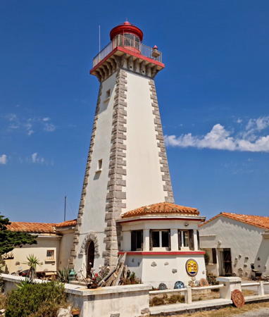
* Cap Leucate
1951. Active; focal plane 66 m (217 ft); two white flashes every 10 s. 19 m (62 ft) square pyramidal masonry tower with lantern and gallery, attached to a 1-story keeper's house. Lighthouse painted white with unpainted granite trim; lantern painted red. A 2024 photo by Nicolas Kristofiles is at the top of this page, Wikimedia has Jacques Le Letty's 2015 photo, DIRM has a page for the lighthouse, Trabas has a photo, Guyomard and Carceller have photos, a good 2007 photo is available, Claude Bihain has a photo, Puelse has an uncluttered postcard view that shows the layout of the station clearly, and Google has a street view and a satellite view. Located on the Chemin du Phare on the north side of Leucate-Plage. Site open, tower closed. . ARLHS FRA-230; FR-1293; Admiralty E0518; NGA 6088.

Jetée du Sud Light, Port-la-Nouvelle, October 2023
Google Maps photo by Fraté92
Port Leucate Jetée Ouest
Date unknown. Active; focal plane 8 m (26 ft); green flash every 4 s. 6 m (20 ft) round tower rising from a triangular 1-story equipment shelter. Lighthouse painted white with a green top. Trabas has Capt. Peter's photo, another photo is available, Philippe Warin has a street view from the east breakwater, and Google has a satellite view. Located on the west (really the north) breakwater of Port Leucate. Accessible only by boat. Site open, tower closed. Admiralty E0517.7; NGA 6096.

Lighthouses of Pyrénées-Orientales

The rugged and scenic coast of Pyrénées-Orientales is called the Côte Vermeille (Vermilion Coast).

Le Barcarès and Canet-en-Roussillon Lighthouses
* Grau Saint-Ange (Le Barcarès)
Date unknown. Active; focal plane 10 m (33 ft); two red flashes every 10 s. 7 m (23 ft) post rising from a triangular 1-story concrete equipment room. Lighthouse painted white. Trabas has Capt. Peter's photo, a drone view is available, and Google has a satellite view and a distant street view. Located at the end of the south breakwater at Le Barcarès, near the northern border of Pyrénées-Orientales. Accessible by walking the pier. Site open, tower closed. Admiralty E0517; NGA 6084.
* Canet-Plage
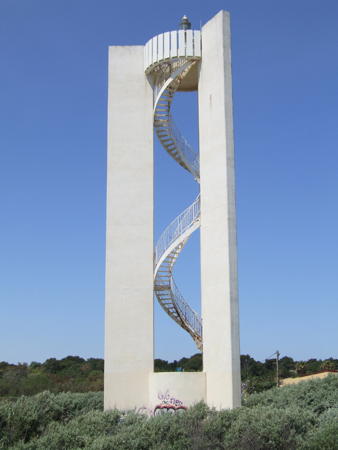
1977. Active; focal plane 27 m (89 ft); four white flashes every 15 s. 24 m (79 ft) triangular concrete tower with gallery and an enclosed equipment room at the base. The light and gallery are supported by three concrete columns, with access via a stairway that spirals almost magically up the open center of the tower. Entire lighthouse is white. Arno Siering's photo is at right, Trabas has Capt. Peter's closeup and Google has a street view and a satellite view. This modern design is by the architectural firm of Cardin, Diatkine et Frémolle of Montpellier. Located on the dunes behind the beach at Canet-Plage, about 800 m (1/2 mi) north of the harbor. Site open, tower closed. . Admiralty E0514.5; NGA 6072.

Canet-Plage Light, Canet-Plage
photo copyright Arno Siering; used by permission
* Canet-Plage Jetée du Sud
Date unknown. Active; focal plane 9 m (30 ft); three red flashes every 12 s. 6 m (20 ft) post centered on a triangular 1-story concrete equipment shelter. Lighthouse is white concrete; the light and its short mast are red. Trabas has Capt. Peter's photo, Sacha Meilleurat has a 2021 view from the sea, J. Kleen has a closeup street view, and Google has a satellite view. Located at the end of the breakwater at Canet-Plage, the beach resort town adjacent to Canet-en-Roussillon. Accessible by walking the breakwater. Site open, tower closed. Admiralty E0515; NGA 6076.

Collioure and Port-Vendres Lighthouses
* Collioure
1886. Active; focal plane 14 m (46 ft); green light, 2 s on, 2 s off. 14 m (46 ft) round stone tower, attached to the end of the mole. There is a stone equipment room at the top of the tower, level with the top of the mole, surmounted by a round cast iron watch room and then the light supported by four ornately curved iron legs. The NGA list gives up and calls this highly unusual light tower simply a "structure." Trabas has Arno Siering's closeup photo, another good closeup and a 2021 closeup are available, Wikimedia has a photo by Roger Davies, and Google has a satellite view and a distant street view. Located at the end of the jetty on the north side of the harbor entrance at Collioure, a small fishing port about 3 km (2 mi) northwest of Port-Vendres. Site open, tower closed. . ARLHS FRA-243; Admiralty E0512; NGA 6056.
Port-Vendres (Fort du Fanal) (2)
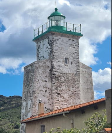
1700 (inactive 1710-1770; station established in the 14th century). Active; focal plane 29 m (95 ft); green light, 3 s on, 1 s off. 18 m (59 ft) square masonry tower with lantern and gallery, painted white; lantern and gallery painted green. A 2022 photo by Fano Kalliste Kors is at right, Wikimedia has Jean-Pierre Bazard's 2011 photo, Chris Bosworth has a photo, Trabas has Capt. Peter's photo, Peter Goulding also has a photo, Sébastien Wehrlé has a 2021 photo, a view across the harbor is available, Huelse has a historic postcard view, and Google has a street view and a satellite view. According to J. Fichou beacon fires were displayed from a tower built here in the 14th century, but that tower was destroyed around 1610. The present tower was included in the fort built by Vauban for Louis XIV in 1684; it became known later as the Fort du Fanal, fanal being a lantern or beacon. Lights were shown from 1700 to 1710 and then continuously from 1770, with more modern equipment being installed in 1843. Located on a bluff on the west side of the harbor entrance at Port-Vendres. Site status unknown (Goulding was not able to reach the tower), tower closed. ARLHS FRA-291; Admiralty E0498; NGA 6024.
* Port-Vendres Range Rear (2)
Date unknown (station established 1858). Active; focal plane 23 m (75 ft); quick-flashing white light, intensified on the range line and synchronized with the front light. 11 m (36 ft) square cylindrical tower, attached to a 2-story residence. Lighthouse painted white with red squares on the front of the tower and a red band at the top; the light is shown through a window in the second square from the top. Trabas has a photo and Google has a street view and a satellite view. Located 200 m (655 ft) south southwest of the front light. Site and tower closed, but there's a good view from the Chemin des Tamarins below the lighthouse. ARLHS FRA-614; Admiralty E0497.1; NGA 6052.

Fort du Fanal Light, Port-Vendres, September 2022
Google Maps photo by Jean-Pierre Bazard
* [Port-Vendres Range Front]
1858. Active; focal plane 12 m (39 ft); quick-flashing white light. 11 m (36 ft) post with gallery, mounted on a square stone pedestal. Gallery painted red. Trabas has Capt. Peter's photo and Google has a satellite view and a distant street view. The rear light was originally mounted on the roof of the keeper's house. Located on the tip of a promontory on the east side of the harbor. Site and tower closed, but there's a good view from the highway turnout just above the light. Admiralty E0497; NGA 6048.
* Port-Vendres Môle de l'Est (Pointe de la Presqu'île)
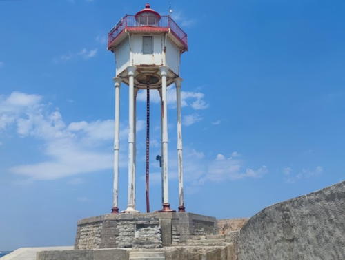
1885. Active; focal plane 20 m (66 ft); red light occulting three times every 12 s. 17 m (56 ft) hexagonal cylindrical cast iron tower with lantern, gallery, and enclosed watch room mounted on six iron legs. Paweł Stelmaszczyk's 2022 photo is at right, Trabas has Capt. Peter's photo, a closeup photo is available, Guyomard and Carceller have a distant view (click on the right arrow) taken from Fort du Fanal on the opposite side of the harbor, Huelse has a historic postcard view, and Google has a satellite view and a street view from across the harbor. The spiral staircase seen in the photo at right has been removed, with the result that the lighthouse stands awkwardly on its very tall legs. This unusual lighthouse was designed by the engineering firm of Parlier and Cutzach, who were asked to design a tower of the least possible weight. Apparently they did a good job, since their work has stood for 120 years. Located at the end of the east breakwater at Port-Vendres; accessible by walking the breakwater. Site open, tower closed. ARLHS FRA-599; Admiralty E0504; NGA 6044.

Môle de l'Est Light, Port-Vendres, July 2022
Google Maps photo by Paweł Stelmaszczyk
* Cap Béar (2)
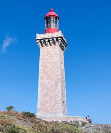
1905 (station established 1836). Active; focal plane 80 m (262 ft); three white flashes every 15 s. 27 m (89 ft) square granite tower with lantern and gallery. The tower is unpainted; lantern painted red. Several 1-story masonry keeper's houses and other station buildings. Marco Xfetti's photo is at right, DIRM has a page for the lighthouse, Trabas has Arno Siering's closeup photo, a good 2007 photo is available, Claude Bihain has a 2009 photo, Humberto Vila has a 2023 closeup, Huelse has a historic postcard view, and Google has a street view and a satellite view. The original lighthouse was a 9 m (30 ft) masonry tower much higher on the slope of the ridge. Having a focal plane of 229 m (751 ft), it was too often obscured by low clouds. Note: the name of the cape is pronounced with two syllables: bay-ar.(The French word for a bear is ourse.) Located on the cape about 2.5 km (1.5 mi) east of Port-Vendres; accessible by road, parking provided. Site open, tower closed. . ARLHS FRA-213; FR-1282; Admiralty E0496; NGA 6020.

Cerbère Lighthouse
* Cap Cerbère (2)
1982 (station establishment date unknown). Active; focal plane 55 m (180 ft); white flash every 4 s. 10 m (33 ft) square cylindrical tower, painted white, enclosed on the land side by three decorative stone "wings"; the light is mounted on a short red mast atop the tower. Trabas has Eckhard Meyer's photo, Mehmet Ataberk Sari has a 2023 photo, Peter Goulding has a photo, Juan Manuel Punzón has a closeup, and Google has a street view and a satellite view. This interesting design is by the Paris architectural firm of Lucien Guerra. The new light replaced a smaller structure much lower on the slope, having a focal plane of 19 m (62 ft). The lighthouse marks the southernmost promontory of mainland France, about 600 m (0.4 mi) north of the Spanish border. Located on the cape, about 1.5 km (1 mi) east of the Cerbère waterfront; accessible by the twisting N114 coastal highway. Parking provided (this is a popular lookout point with a wide view of the Mediterranean). Site open, tower closed. . ARLHS FRA-215; Admiralty E0492; NGA 6008.

Information available on lost lighthouses:


Cap Béar Light, Port-Vendres, September 2022
Google Maps photo by Marco Xfetti

Notable faux lighthouses:

Adjoining pages: East: Marseille Area | South: Catalonia

Return to the Lighthouse Directory index | Ratings key

Posted April 3, 2006. Checked and revised May 11, 2024. Lighthouses: 46. Site copyright 2024 Russ Rowlett and the University of North Carolina at Chapel Hill.