Lighthouses of Spain: Catalonia

The Kingdom of Spain (Reino de España in Spanish) occupies nearly 85% of the Iberian Peninsula in southeastern Europe with coastlines facing south and southeast on the Mediterranean Sea and northwest on the Atlantic Ocean. Spain also includes the Balearic Islands in the Mediterranean, the Canary Islands in the Atlantic, and the cities of Ceuta and Melilla on the north coast of Morocco.

Since 1978 Spain has been divided into 17 regions called autonomous communities (comunidads autónoma) that have been granted varying degrees of autonomy by the central government. The autonomous communities are subdivided into provinces (provincias).

Catalonia is an autonomous community located in the northeastern corner of the country. The name of the region is spelled Cataluña in Spanish and Catalunya in the Catalan languange spoken by most of the inhabitants. Three of the region's four provinces face the Mediterranean: Girona, Barcelona, and Tarragona. The City of Barcelona, the regional capital, is Spain's second largest city. Catalonia is one of three autonomous communities described officially as a nationality (nacionalidad), and since about 2010 there has been a well-supported movement for the independence of Catalonia.

The word for a lighthouse is faro in Spanish but its use is generally restricted to the larger coastal light stations. Smaller lighthouses are called balizas (beacons). In Spanish isla is an island, cabo is a cape, punta is a promontory or point of land, péñon is a rock, arrecife is a reef, bahía is a bay, ría is an estuary or inlet, estrecho is a strait, río is a river, and puerto is a port or harbor. In Catalan the word for a lighthouse is far, balisa is a beacon, illa is an island, cap is a cape, punt is a promontory or point of land, roca is a rock, escull is a reef, badia is a bay, ria is an estuary or inlet, estret is a strait, riu is a river, and port is a port or harbor.

The navigational lights in Spain are the responsibility of the national port authority, Puertos del Estado, but most of them are operated and maintained by regional port authorities. In Catalonia there are two port authorities, Tarragona and Barcelona. The Barcelona authority is also responsible for lighthouses in Girona.

ARLHS numbers are from the ARLHS World List of Lights. ES numbers are from the Spanish national list of lights, Libro de Faros. Admiralty numbers are from volume E of the Admiralty List of Lights & Fog Signals. U.S. NGA List numbers are from Publication 113.

General Sources
Libro de Faros y Señales de Niebla
Online edition of the official Spanish light list.
Online List of Lights - Spain East Coast
Photos by various photographers posted by Alexander Trabas. Many of the photos are by Arno Siering or Capt. Peter Mosselberger ("Capt. Peter").
Anexo: Faros de España
Index to Spanish lighthouses in the Spanish edition of Wikipedia.
Phares de Catalogne
A portfolio of about 20 fine photos by Karl R. Spitzer posted by Alain Guyomard and Robert Carceller.
Lighthouses in Catalonia
Photos by various photographers available from Wikimedia.
World of Lighthouses - South and East Coasts of Spain
Photos by various photographers available from Lightphotos.net.
Spain Lighthouses
Aerial photos posted by Marinas.com.
Spanische Leuchttürme auf historischen Postkarten
Historic postcard images posted by Klaus Huelse.
GPSNauticalCharts
Navigational chart information for Catalonia.
Navionics Charts
Navigational chart information for Catalonia.


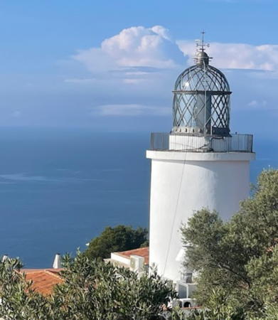
Calella Light, Calella, January 2024
Instagram photo by Josep Marcé

Lighthouses of Girona

Lighthouses in Girona are operated and maintained by the Autoridat Portuària de Barcelona. The mountainous coastline of Girona is well known to travelers as the Costa Brava (Wild Coast).

Alt Empordà (Cabo Creus Area) Lighthouses
* Punta s'Arnella (Port de la Selva)
1913. Active; focal plane 22 m (72 ft); white flash every 5 s. 13 m (43 ft) square cylindrical masonry tower with lantern and gallery, centered on the roof of a 1-story masonry keeper's house. Keeper's house unpainted; light tower painted white; lantern is gray metallic. Trabas has a good photo by Heike and Friedrich Klatt, Quim Espluga has a 2022 photo, Wikimedia has several photos, and Google has a sea view, a street view and a satellite view. La Selva is a small port on the north side of the Cap de Creus massif. Located on a promontory on the west side of the harbor of Port de la Selva. Parking provided. Site and tower closed, but the lighthouse can be viewed from outside the fence. . ARLHS SPA-287; ES-31780; Admiralty E0488; NGA 5992.
** Cap de Creus (Cabo Creus)
1853. Active; focal plane 87 m (285 ft); two white flashes every 10 s. 11 m (36 ft) 2-stage cylindrical masonry tower, lower part square and upper part round, with lantern and double gallery, centered on the roof of a large 1-story masonry keeper's house. Lighthouse painted white with unpainted stone trim; lantern is all glass including the dome. A photo is at right, Trabas has a photo by Siering, Kamil Krakowiak has a 2022 photo, Wikimedia has Michael Pfeiffer's 2010 photo at right and a 2005 photo, Huelse has a historic postcard view, and Google has a street view and a satellite view. This is Catalonia's second oldest lighthouse, marking the easternmost point of the Spanish mainland and the western entrance to France's Golfe du Lion. Perched on a spectacular promontory overlooking the Mediterranean, the lighthouse has been converted into a visitor center for the popular Cabo Creus national park; thus it is now one of Spain's best known and most visited lighthouses. Located on the Punta de la Esquenya, about 500 m (1/4 mi) southwest of the point of the cape. Site and lighthouse open, tower status unknown. Limited parking available. Site manager: Parque Natural de Cap de Creus. . ARLHS SPA-059; ES-31730; Admiralty E0486; NGA 5988.
Cala Nans (Cadaqués)
1864. Active; focal plane 33 m (108 ft); five white flashes, in a 4+1 pattern, every 25 s. 7 m (23 ft) round cylindrical masonry tower with lantern and gallery mounted on a small 1-story keeper's house. Lighthouse painted white; lantern is metallic gray. Trabas has Capt. Peter's photo, Xavier Cusell has a closeup, Olivier Sallou has a 2022 photo, Huelse has a historic postcard view, and Google has a sea view and a satellite view. This little lighthouse has a wild location overlooking the natural harbor of Cadaqués, tucked into the Cap de Creus massif. In 1982 residents of the tiny fishing village protested vigorously when the Comisíon de Faros announced plans to demolish the dilapidated lighthouse and replace it with a modern post light. They prevailed, and the lighthouse was restored instead. The light station is located in a large national park. Located on a steep promontory on the south side of harbor entrance at Cadaqués. Accessible by hiking the access road. Site open, tower closed. Site manager: Parque Natural de Cap de Creus. . ARLHS SPA-075; ES-31680; Admiralty E0484; NGA 5984.

Cap Creus Light, Cadaqués, September 2010
Wikimedia Creative Commons photo by Michael Pfeiffer
* Roses (Punta de la Batería, Punta Blancals)
1864. Active; focal plane 24 m (79 ft); white light occulting four times every 15 s. 11 m (36 ft) round cylindrical masonry tower with lantern and gallery, centered on the roof of a 1-story masonry keeper's house. Lighthouse painted white; lantern is metallic gray. Trabas has Siering's closeup photo, Wikimedia has several photos, a 2019 photo is available, Huelse has a historic postcard view, and Google has a street view, a sea view, and a satellite view. This lighthouse is built on the ruins of the Castillo de la Trinidad, overlooking the north shore of the Golf de Roses on the south side of the Cap de Creus massif. Located on a promontory about 3 km (2 mi) southeast of Roses. Site and tower closed, but the lighthouse can be viewed from nearby. . ARLHS SPA-237; ES-31610; Admiralty E0476; NGA 5972.

Baix Empordà Lighthouses
Illes Medes (Islas Medas)
1868. Active; focal plane 87 m (285 ft); four white flashes every 24 s. 11 m (36 ft) square cylindrical masonry tower with lantern and gallery, centered on the roof of a 1-story masonry keeper's house. The original lantern was removed many years ago and the modern lantern was added sometime between 2007 and 2013. Lighthouse painted white, lantern red. Laura Clotas has a 2021 photo, Trabas has Eckhard Meyer's view from the sea, Wikimedia also has a view, Marinas.com has aerial photos, Huelse has a historic postcard view showing the tower with its original lantern, and Google has a street view and a satellite view. This was the last lighthouse built in the program of the 1860s, which lit most of the Spanish coast. Difficult and dangerous to access, this was one of the first lighthouses in Spain to be automated (1933) and one of the first to be converted to solar power (1982). Located atop a rocky islet about 1.5 km (1 mi) east of L'Estartit. Inaccessible, and difficult to view even from the sea. Site and tower closed. . ARLHS SPA-161; ES-31300; Admiralty E0472; NGA 5944.
* Cap Sant Sebastià (Cabo de San Sebastian)
1857 (José Ma. Faquinetto). Active; focal plane 167 m (548 ft); white flash every 5 s. 13 m (43 ft) round cylindrical masonry tower centered on the roof of a 2-story masonry keeper's house. Lighthouse painted white; lantern is all glass including the dome. A 2023 photo is at right, Wikimedia has a good 2021 photo by Jonatan Romero, Daniel Ferriera Baltà has a nice photo, Trabas has Siering's photo, Anna Aurich has a 2021 closeup, Huelse has a historic postcard view, and Google has a street view and a satellite view. One of the most important and most famous lighthouses of Spain's Mediterranean coast. The cape is a bulge in the coastline that marks the southeastern end of the Pyrenees and the southwestern corner of the Golfo de Léon, or Golfe du Lion as it is better known in French. It appears that the original first-order lens has been replaced by a powerful modern lens. The listed range of the light is 32 nautical miles (59 km, 37 mi), but the port authority claims it can often be seen at a distance of 50 nautical miles (93 km, 58 mi). Located high on the cape on the east side of Llafranc and about 4 km (2.5 mi) southeast of Palafrugell. Site and tower closed, but the lighthouse can be viewed from outside the wall surrounding the station. Very limited parking available. . ARLHS SPA-045; ES-31250; Admiralty E0470; NGA 5940.
[Islote Hormiga Grande]
Date unknown. Active; focal plane 14 m (46 ft); three white flashes every 9 s. 6 m (20 ft) square column rising from a square 1-story equipment shelter. Lighthouse is white. Trabas has a photo, Domaine Cantalauze has a 2021 view from the sea, and Google has a satellite view and a closeup street view. Located on the highest point of a rocky reef off the point of Cap Roig, about 5 km (3 mi) northeast of Palamós. Accessible only by boat. Site open, tower closed. ES-31140; Admiralty E0467; NGA 5932.

Cap Sant Sebastià Light, Palafrugell, June 2023
Google Maps photo by Rumah Barcelona
* Palamós (Punta del Molí, Punta del Molino)
1865. Active; focal plane 22 m (72 ft); five white flashes, in a 1+4 pattern, every 18 s. 8 m (26 ft) hexagonal cylindrical masonry tower, with lantern, round watch room, and gallery. Lighthouse painted white; lantern is gray metallic. 1-story masonry keeper's house. Alexandre Nunes de Oliveira's 2022 photo is at right, Trabas has Siering's closeup photo, Carlos Olmo also has a closeup, Tatiana Permiakova has a 2018 photo, Guy Vivent has a 2022 photo, Huelse has a postcard view dated 1900, and Google has a street view and a satellite view. The lighthouse was restored in 1975 to repair numerous cracks in the masonry, including many created by nearby bombing during the Spanish Civil War. Located on a sharp promontory south of the harbor of Palamós. Limited parking available. Site open, tower closed. . ARLHS SPA-224; ES-31041; Admiralty E0462; NGA 5916.

La Selva Lighthouse
*** Tossa de Mar (Cabo Tossa)
1919. Active; focal plane 60 m (197 ft); four white flashes, in a 3+1 pattern, every 20 s. 12 m (36 ft) square cylindrical masonry tower with lantern and gallery, attached to the front of a 1-story masonry keeper's house. Lighthouse painted white with unpainted stone trim; lantern dome is gray metallic. Isidre Blanc has a photo, Trabas has Siering's photo, a closeup is available, Wikimedia has photos, Marinas.com has aerial photos, Huelse has a historic postcard view, Roberto Roessler has a closeup street view, and Google has a satellite view. Tossa de Mar is a medieval fortified town. Most of the ancient castillo has vanished into ruins (one ruined tower was demolished to provide stone for the lighthouse), but the walls are largely intact and many medieval buildings also remain. Located at the point of the cape above the walled town, with a sweeping view of the Mediterranean. No parking at the lighthouse but it is accessible by a hike uphill from town. Site open, tower open for climbing although no information has been found on the schedule. . ARLHS SPA-051; ES-30910; Admiralty E0453; NGA 5896.

Palamós Light, Palamós, December 2022
Google Maps photo by Alexandre Nunes de Oliveira
   

Lighthouses of Barcelona

Lighthouses in Barcelona Province are operated and maintained by the Autoridat Portuària de Barcelona.

Maresme Lighthouse
 
* Calella (Cerro de la Torreta)
1859. Active; focal plane 50 m (164 ft); five white flashes, in a 3+2 pattern, every 20 s. 13 m (43 ft) round cylindrical masonry tower with lantern and double gallery, rising from the front of a 1-story masonry keeper's house. Original 3rd order Fresnel lens in use. Lighthouse painted white with unpainted stone trim; lantern is all glass including the dome. Josep Marcé's 2024 photo is at the top of this page, Trabas has an excellent photo by Siering, Robert Agran has a photo, Jose-Maria Gomez Angosto has a 2021 closeup, Wikimedia has numerous photos, Marinas.com has aerial photos, Huelse has a historic postcard view, and Google has a satellite view and a closeup street view. During the Spanish Civil War the light station was fortified with anti-aircraft guns and was attacked several times but not heavily damaged. Located on a bluff behind the beach on the west side of Calella, about 65 km (40 mi) northeast of Barcelona. Site and tower closed, but the lighthouse can be viewed from nearby. Parking available. . ARLHS SPA-076; ES-30810; Admiralty E0448; NGA 5888.

Barcelonès (Barcelona City) Lighthouses
* Barcelona (Torre del Rellotge, Torre del Reloj)
1772. Inactive since about 1860. Approx. 20 m (66 ft) square pyramidal masonry clock tower; the top of the tower formerly carried a lantern and gallery instead of the clock faces seen today. Alberto Gijon Molina has a photo, a closeup is available, Wikimedia has several photos, Google has a distant street view, and Bing has an aerial view. Huelse has a historic postcard view of the lighthouse and a second postcard view of the building after it was converted to a clock tower in 1911. Lights were provided in Barcelona as early as 1697, but this is the only survivor of the rather large number of harbor lights built and removed at various times as the port developed. Located at the Moll des Pescadors on the downtown Barcelona waterfront. Site open, tower closed. . ARLHS SPA-344.
Montjuïc (2)
1925 (station established 1906). Active; focal plane 108 m (354 ft); two white flashes every 15 s. 13 m (43 ft) 3-story masonry keeper's house with lantern centered on the roof. The front of the lighthouse is painted white with red trim; the lantern is unpainted gray metallic. Aníbal Dopazo Lajarín's 2021 photo is at right, Trabas has a photo by Darlene Chisholm, Javier Ortega Figueiral has a 2011 photo, Lluís Campano Balletbò has a 2021 closeup, and Google has a satellite view. Montjuïc is a mountain that rises steeply above the harbor of Barcelona, crowned by the historic Castillo de Montjuïc. The lighthouse is built partway up the mountain in an area not open to the public. One can look down on the lighthouse from the area in front of the Castillo, and drivers on the Ronda del Litoral expressway at the foot of the mountain can glance up and see it. Site and tower closed. . ARLHS SPA-183; ES-29700; Admiralty E0400; NGA 5760.

Montjuïc Light, Barcelonès,May 2021
Google Maps photo by Aníbal Dopazo Lajarín
Barcelona North Harbour Entrance East Breakwater
2014(?). Active; focal plane 16 m (52 ft); two green flashes every 7 s. 13 m (43 ft) round cylindrical concrete tower with lantern and gallery, painted with green and white spiral bands. Trabas has Rainer Arndt's photo, José Luis Roselló Dominguez has a view from the sea, and Google has a satellite view. Located at the end of the breakwater at the entrance to the traditional harbor. Site status unknown. ES-30377.4; Admiralty E0434.591, NGA 5786.
Barcelona Entrance Channel East Breakwater
2014(?). Active; focal plane 16 m (52 ft); green flash every 5 s. 13 m (43 ft) round cylindrical concrete tower with lantern and gallery, painted with green and white horizontal bands. Trabas has Jim Smith's closeup photo and Google has a satellite view. The lantern was added in 2015. Located at the end of the long breakwater protecting the main commercial harbor of Barcelona. Site status unknown. ES-29680.17; Admiralty E0401.55, NGA 5761.

Baix Llobregat Lighthouse
* Llobregat
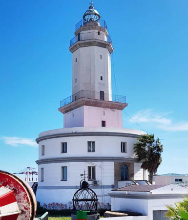
1852 (Simón Ferrer). Active; focal plane 32 m (105 ft); white flash every 5 s. 31 m (102 ft) cylindrical masonry tower, the lower part square and the upper part octagonal, with lantern and three galleries, rising from the center of a circular 2-story keeper's house. The lighthouse is white with gold-colored trim; the lantern is all glass including the dome. A 2021 photo by Nacho Gálvez is at right, Trabas has a photo by Capt. Peter Mosselberger, Dani Martínez has a 2017 photo, Paco Gavilan has another photo, Rása Éva has a 2022 photo, and Google has a satellite view. This historic lighthouse, Catalonia's oldest, is now surrounded by industrial development on the south side of Barcelona's harbor. It has had an eventful history. In its earlier days it was threatened by beach erosion, and for a time it was surrounded by water, but fill now has it definitely on dry land. It was actually ordered demolished at the time the Montjuïc lighthouse was built (1925), but mariners' protests saved it from destruction. Wilfried Kalinowski visited in March 2019 and found the lighthouse under restoration; it's possible it may be opened as a tourist attraction. Located on the north side of the mouth of the Río Llobregat, on the mainland opposite the entrance to the port of Barcelona. Site open, tower closed. . ARLHS SPA-001; ES-29630; Admiralty E0398; NGA 5752.

Garraf Lighthouse
** Vilanova i la Geltrú (Sant Cristòfol, Punta San Cristóbal) (2)
1905 (station established 1866). Active; focal plane 27 m (89 ft); three white flashes every 8 s. 21 m (69 ft) round masonry tower with lantern and gallery, attached to a 1-story masonry keeper's house. Cristina Molano Flores has a 2022 photo, Trabas has a good photo, Wikimedia has Angelina Llop's photo, and Google has a street view and a satellite view. The keeper's house has been renovated as a maritime museum, the Museu del Mar (Museum of the Sea). Located behind the beach on Punta Sant Cristòfor (Punta San Cristobol) in Vilanova i la Geltrú, a seaside town about halfway between Tarragona and Barcelona. Site open, museum open daily except Mondays mid June through mid September and Wednesday through Sunday the rest of the year; tower closed. Site manager: Ajuntament de Vilanova i la Geltrú (Espai Far ). ARLHS SPA-272; ES-29340; Admiralty E0396; NGA 5708.

Llobregat Light, Barcelonès, May 2021
Instagram photo by Nacho Gálvez

Lighthouses of Tarragona

Lighthouses in Tarragona are operated and maintained by the Autoritat Portuària de Tarragona.

Tarragonès (Tarragona City) Lighthouses
* Torredembarra
2000. Active; focal plane 58 m (190 ft); five white flashes every 30 s. 38 m (125 ft) octagonal cylindrical concrete tower with lantern and a unique "roofed" watch room. The tower is white; watch room covered by brown siding. C.W. Bash has posted a fine photo by Miguel Ángel Sánchez Terry, Joan Grífols has a 2010 closeup photo, Trabas has a good view from the sea, Wikimedia has a photo, a 2022 photo is available, Leo Kaessner has a street view, and Google has a satellite view. This unusual modern lighthouse is a late addition to Spain's efforts in the 1990s to improve navigational aids along all its coasts. The light was inaugurated in a millennium celebration on New Year's Day 2000. Located on Punta de la Galera, at the end of the Avenguda de la Galera in Torredembarra, a residential community about 13 km (8 mi) east of Tarragona. Site open, tower closed. . ARLHS SPA-130; ES-29105; Admiralty E0393.7; NGA 5691.5.
* Tarragona Muelle de Aragón
1923. Inactive as an official aid to navigational since 1990, but a decorative light (two white flashes every 12 s) is displayed. 15 m (49 ft) hexagonal masonry tower with lantern and gallery, rising from a square 1-story masonry keeper's house. The lighthouse is red with unpainted trim. George Nikolov has a 2017 photo, Aleix Fortuny Asensio has a 2018 photo, and Google has a satellite view. The lighthouse was formerly painted light blue, as seen in a 2009 closeup. When it was built, this lighthouse stood at the end of the Tarragona Dique de Levante, the main breakwater, but later extensions of the breakwater caused the lighthouse to become less and less useful. The navigational function of the light was taken over by the relocated Faro de la Banya (next entry) in 1988. After deactivation the building deteriorated and part of it was actually demolished. A restoration was launched in 1997 and in 1999 the lighthouse was relit with its historic characteristic. The light is shielded from the sea to avoid confusing ships. Located near an elbow of the Tarragona main breakwater. Site open, tower closed. ARLHS SPA-346.
*** Tarragona Dique de Levante (La Banya (1))
1864. Reactivated (inactive 1978-1988); focal plane 27 m (89 ft); white light, 2 s on, 1 s off. 18 m (59 ft) round cylindrical cast iron tower with lantern and gallery, rising from the center of an hexagonal 1-story cast iron keeper's house mounted on pilings. Lighthouse painted white, lantern gray. A 2023 photo is at right, Antonio Delgado Godino has a good photo, Trabas has an excellent closeup, and Google has a street view and a satellite view. The tower is floodlit at night. This lighthouse, the original Far de la Banya (see below), was relocated in 1984 to the east breakwater (Dique de Levante) in Tarragona. It was restored in 1988 and converted to a restaurant in 1992. However, in 1996 changes to the layout of the port temporarily eliminated public auto access to the site and the restaurant was closed. In 2003 the lighthouse was renovated and reopened as the Museu de Fars (Lighthouse Museum), with exhibits on the history of Spanish lighthouses and the lighthouses of Tarragona province. Located near the end of the main breakwater of Tarragona. Site open, museum open every Sunday, top of tower closed. Site manager: Museu del Port de Tarragona. . ARLHS SPA-108; ES-28761; Admiralty E0388; NGA 5652.


Tarragona Dique de Levante Light, January 2023
(relocated 1864 La Banya Light)
Instagram photo by Terrats&Caus

Tarragona Dique-Rompeolas (Outer Breakwater)
Date unknown. Active; focal plane 22 m (72 ft); green light, 1.5 s on, 3.5 s off. 11 m (36 ft) round hourglass-shaped fiberglass tower, colored green with a white base. Trabas has a photo, a closeup is available, Juanjo Fuster has a street view, and Google has a satellite view. Located at the end of the Tarragona breakwater, an extension of the Dique de Levante. Accessible by walking the pier (it's a long walk). Site open, tower closed. ES-28762; Admiralty E0388.12; NGA 5682.
* Cap de Salou
1858. Active; focal plane 43 m (141 ft); four white flashes every 20 s. 11 m (36 ft) round cylindrical masonry tower with lantern and gallery, rising from a 1-story keeper's house. Lighthouse painted white with one narrow red band under the gallery; lantern is all glass including the dome. Miguel Ángel Sánchez Terry, the keeper, took the photo at right. Wil Corzo has a 2021 photo, Trabas has a view from the sea, Marinas.com has aerial photos, Huelse has a historic postcard view, Alberto Ayensa has a street view from the beach boardwalk, and Google has a satellite view. This is the traditional landfall light for Tarragona. Located on the point of the cape at Cap de Salou, about 10 km (6 mi) southwest of Tarragona. Site and tower closed, but the lighthouse can be viewed from nearby. . ARLHS SPA-043; ES-28700; Admiralty E0386; NGA 5632.

Baix Camp Lighthouse
* Cambrils Dique de Poniente (West Mole)
Date unknown. Active; focal plane 13 m (43 ft); three red flashes every 9 s. 9 m (30 ft) post centered on a circular 1-story concrete equipment room. Entire lighthouse painted red. Trabas has Eckhard Meyer's photo, and Google has a street view, a sea view and a satellite view. Located at the end of the west breakwater of Cambrils. Accessible by walking the pier. Site open, tower closed. ES-28580; Admiralty E0384; NGA 5616.

Cap de Salou Light, Tarragona, December 2006
Flickr Creative Commons photo by lightkeeper Miguel Ángel Sánchez Terry,
posted by C.W. Bash

Baix Ebre (Ebro Delta) Lighthouses
The Ebre (Ebro) River is the longest river entirely in Spain. It has formed a large delta, an important wetland; much of it is protected as the Parc Naturel del Delta de l'Ebre.
El Fangar (3)
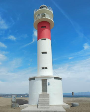
1986 (station established 1864). Active; focal plane 20 m (66 ft); two flashes every 24 s, white or red depending on direction. 18 m (56 ft) round cylindrical concrete tower with lantern and double gallery, rising from a circular 1-story concrete equipment room. Lighthouse painted white with one narrow red band under the galleries. Igor Atlas has a 2019 photo (also seen at right), Wikimedia has Alberto Rovi's 2013 photo, Jordi Domènech i Arnau has a good photo, Miguel Ángel Sánchez Terry has a great photo, Trabas also has a photo, Juank Casado has a street view from the beach, and Google has a satellite view. Sibling of the Far de la Banya. The Punta del Fangar is on a broad sandy spit that has evolved from the north side of the Río Ebro delta. The area is included in a national park and is accessible by 4WD vehicles. The original lighthouse had a lantern centered on the roof of a small keeper's house, mounted on pilings above the sand; it was demolished in 1972 and replaced provisonally by an 8 m (26 ft) steel tower. Located on the beach about 800 m (1/2 mi) from a road, this lighthouse is much easier to reach than the Faro de la Baña. Site open, tower closed. Site manager: Parc Natural del Delta de l'Ebro. . ARLHS SPA-089; ES-28300; Admiralty E0380; NGA 5600.
* Río Ebro (El Garxal, Garratxal)
Date unknown. Active; focal plane 13 m (43 ft); two white flashes every 15 s. 12 m (39 ft) round barbell-shaped metal tower mounted on a square concrete pad. Entire lighthouse painted yellow. Anxo Regueira López has a 2021 photo, Trabas has Eckhard Meyer's photo, Wikimedia has a 2014 photo, and Google has a street view and a satellite view. Located on the north side of the entrance to the Río Ebro in Ríumar. Accessible by road. Site open, tower closed. . ARLHS SPA-297; ES-28000; Admiralty E0376; NGA 5599.
Cap Tortosa (3)
1984 (station established 1864). Active; focal plane 18 m (59 ft); white flash every 6 s. 18 m (59 ft) square steel skeletal tower rising from a platform supported by pilings; there is an enclosed equipment shelter on the platform. The tower is metallic gray. Sea-seek.com has a photo, a kayaker has a photo, a distant view is available, and Trabas has a very distant view, but the light is not shown in Google's satellite view. This light replaced the historic Faro de Buda, a 50 m (165 ft) octagonal skeletal tower with central cylinder, lantern and gallery, and keeper's quarters. Huelse has a postcard view of that lighthouse; it stood near the mouth of the Ebro and was destroyed by a storm in 1961. Its first successor, a skeletal tower, collapsed in the surf after only three years of service. Apparently there was no light at the cape from 1965 to 1984. This ungainly lighthouse is located about 5 km (3 mi) offshore; there is a distant view from the beach at the point of the cape. Accessible only by boat. Site open, tower closed. ARLHS SPA-050; ES-28050; Admiralty E0377; NGA 5598.

El Fangar Light, Delta de l'Ebre, June 2019
Google Maps photo by Igor Atlas

Montsià Lighthouses
La Banya (Punta de la Baña) (2)
1978 (station established 1864). Active; focal plane 27 m (89 ft); two flashes every 5 s, white or red depending on direction. 26 m (85 ft) round cylindrical concrete tower with lantern and double gallery, rising from a circular 1-story concrete equipment room. Lighthouse painted with black and white horizontal bands. Greg Grzegorz Sobieraj has a 2017 closeup photo, another photo is available, Greg Grzegorz Sobieraj has a colorful 2021 sunset photo, Trabas has a very distant view, and Google has a street view and a satellite view. Punta de la Banya is on a broad, sandy spit that has evolved from the south side of the Río Ebro delta. The area is now included in the Parc Naturel del Delta de l'Ebre; it is usually accessible by 4WD vehicles and parking is provided. Boat transportation is also available from Sant Carles de la Ràpita. The original lighthouse survives; it has been relocated to a second career in Tarragona (see above). Located about 10 km (6 mi) from the base of the spit, east of Sant Carles de la Ràpita. Accessible by boat or by a long trek in a 4WD vehicle. Site open, tower closed. Site manager: Parc Natural del Delta de l'Ebre. . ARLHS SPA-209; ES-27470; Admiralty E0370; NGA 5568.
Punta Corballera (El Galacho)
Date unknown. Active; focal plane 13 m (43 ft); flash every 4 s, white or green depending on direction. 12 m (39 ft) round barbell-shaped metal tower mounted on a square concrete pad. Entire lighthouse painted green. Trabas has Eckhard Meyer's photo and Google has a satellite view and a distant sea view. Located at the southwestern end of the sand spit on the south side of the Río Ebro delta. Accessible by road. Site open, tower closed. ARLHS SPA-058; ES-27830; Admiralty E0371.2; NGA 5572.
* Sant Carles de la Ràpita (San Carlos de la Rapita, Punta Senieta)
1864. Active; focal plane 10 m (33 ft); red light occulting four times every 10 s. 7 m (23 ft) round cylindrical masonry tower with lantern and gallery, centered on a 1-story keeper's house. Nicolas Gambetta Ruiz Diaz has the 2019 photo at right, Trabas has a good closeup photo, Luis Padrol Farre has a 2024 photo, Wikimedia has a good 2013 photo, and Google has a street view and a satellite view. This lighthouse guides ships in the Port dels Alfacs (Puerto de los Alfaques), the bay sheltered by the barrier spit of Punta de la Banya. Located at the end of Carrer del Far, on Punta de la Senieta near the south end of the waterfront in Sant Carles de la Ràpita. Parking available. Site open, tower closed. . ARLHS SPA-264; ES-27880; Admiralty E0373; NGA 5576.

Information available on lost lighthouses:

  • Barcelona Rompeolas (Far del Trencaones) (1927-1968), Barcelona. The lighthouse was removed due to extension of the breakwater. Huelse has a postcard photo of the lighthouse.
  • Ille de Buda (1864-1961), Ebre Delta, Tarragona. The lighthouse was destroyed by a storm in 1961; it has been replaced by the offshore Cap Tortosa lighthouse (see above).

Sant Carles de la Ràpida Light, Sant Carles de la Ràpida, January 2019
Google Maps photo by Nicolas Gambetta Ruiz Diaz

Notable faux lighthouses:

Adjoining pages: North: Languedoc-Roussillon | East: Mallorca and Menorca | Southeast: Ibiza and Formentera | South: Valencia and Murcia

Return to the Lighthouse Directory index | Ratings key

Posted February 25, 2006. Checked and revised May 18, 2024. Lighthouses: 29. Site copyright 2024 Russ Rowlett and the University of North Carolina at Chapel Hill.