Lighthouses of France: Ille-et-Vilaine

France (officially the French Republic, République française) has coasts facing south on the Mediterranean Sea, west on the open Atlantic Ocean, and north on the English Channel (La Manche in French). Long a leader in lighthouse design, France has scores of famous and historic lighthouses. And it was a French engineer and physicist, Augustin-Jean Fresnel (1788-1837), who invented the powerful and beautiful lenses used in lighthouses around the world.

The old French province of Bretagne (Brittany) occupies a peninsula at the northwestern corner of France separating La Manche (the English Channel) from the Golfe de Gascogne (Bay of Biscay). Like Wales Bretagne is an ancient Celtic country that maintained its independence until the end of the fifteenth century. Today it is divided into four départements of the French Republic. This page includes lighthouses of the department of Ille-et-Vilaine at the northeastern corner of Bretagne. The department is named for its two rivers, the Ille and the Vilaine.

The French word for a lighthouse, phare, is often reserved for the larger coastal lighthouses; a smaller light or harbor light is called a feu (literally "fire," but here meaning "light") or a balise (beacon). The front light of a range (alignement) is the feu antérieur and the rear light is the feu postérieur. In French île is an island, cap is a cape, pointe is a promontory or point of land, roche is a rock, récife is a reef, baie is a bay, estuaire is an estuary or inlet, détroit is a strait, rivière is a river, and havre is a harbor. The Breton word for a lighthouse is tour-tan; enez is an island, and men is a rock or reef.

Aids to navigation in France are maintained by the Bureau des Phares et Balises, an agency of the Direction des Affaires Maritimes (Directorate of Maritime Affairs). The Directorate has four regional offices (called Directions Interrégionale de la Mer, or DIRM) at Le Havre, Nantes, Bordeaux, and Marseille. Lights in Brittany are managed by the DIRM Nord-Atlantique - Manche Ouest (DIRM-NAMO) at Nantes.

ARLHS numbers are from the ARLHS World List of Lights. FR numbers are the French light list numbers, where known. Admiralty numbers are from volume A of the Admiralty List of Lights & Fog Signals. U.S. NGA List numbers are from Publication 114.

General Sources
DIRM - Phares de l'Ille-et-Vilaine
Information on the major historic lighthouses.
Les Sentinelles des Mers - France - Bretagne
Photos and information posted by Guy Detienne.
Online List of Lights - France North Coast
Photos by various photographers posted by Alexander Trabas. Many photos for the French coast are by Capt. Peter Mosselberger ("Capt. Peter").
Le Phare à travers le Monde
A large, well known site maintained by Alain Guyomard and Robert Carceller.
Lighthouses of Bretagne
Excellent photos by Marc de Kleijn.
Leuchttürme.net - Frankreich
Photos and notes by Malte Werning.
Lighthouses in Ille-et-Vilaine
Photos available from Wikimedia.
Lighthouses in France
Aerial photos posted by Marinas.com.
Phareland, le Site des Phares de France
This comprehensive site has good photos and information about the major lighthouses.
Société Nationale pour le Patrimoine des Phares et Balises (S.N.P.B.)
The French national lighthouse preservation organization.
Französische Leuchttürme
Historic photos and postcard images posted by Klaus Huelse.
GPSNavigationCharts
Navigation chart information for Bretagne.
Navionics Charts
Navigation chart for Bretagne.


Grand Jardin Light, Saint-Malo, Jluy 2023
Instagram photo by Titouan Bellenger
Dinard and Saint-Malo (Saint-Malo Harbor) Lighthouses
Les Courtis
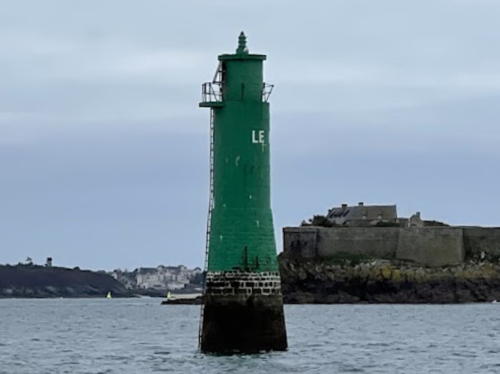
Date unknown. Active; focal plane 14 m (46 ft); green flash every 4 s. 21 m (69 ft) round multistage stone tower, painted green. Trabas has Capt. Peter's photo and Google has a satellite view. (Note: The large apparent discrepancy between tower heights and focal planes for the offshore St.-Malo lights is caused by the large tidal range: a considerable part of the towers is covered at high tide.) Located on a waveswept rock about 1.1 km (0.7 mi) northwest of the Phare du Grand Jardin. Accessible only by boat in rough seas. Site and tower closed. ARLHS FRA-344; Admiralty A1674; NGA 7976.
Grand Jardin (feu antérieur) (2)
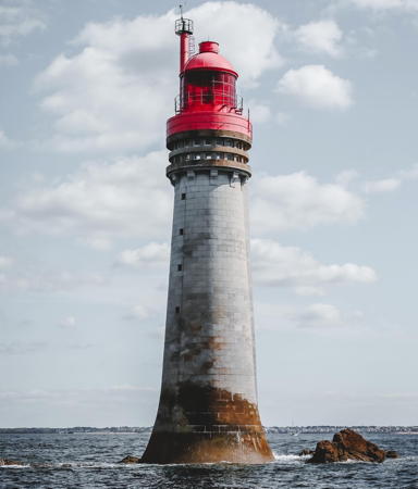
1949 (station established 1868). Active; focal plane 24 m (79 ft); two red flashes every 10 s. 38 m (125 ft) round stone tower with lantern and gallery. Tower painted white; lantern and gallery are red, except the lantern dome is unpainted metal. Titouan Bellenger's photo is at the top of this page, Detienne has a page for the lighthouse, Guyomard and Carceller have good photos, a 2007 closeup is available, Trabas has a great photo by Capt. Peter, Pete Wall has a 2022 photo, and Google has a satellite view. This lighthouse marks the beginning of the channel entering the harbor of Saint-Malo. Huelse has a historic postcard view of the original lighthouse; it was blown up by German troops in August 1944. The replacement tower is very similar to the original except it has a larger lantern. The lighthouse serves as the front light for two ranges; for the Grande Porte range the rear tower is the Phare de Rochebonne and for the outer Petite Porte range the rear light is the Phare de la Balue. Located on a waveswept rock off the west end of the Île de Cézembre about 7 km (4 mi) northwest of the St.-Malo waterfront. Accessible only by boat in rough seas. Site and tower closed. . ARLHS FRA-030; FR-0535; Admiralty A1676; NGA 7980.
Le Buron
Date unknown. Active; focal plane 15 m (49 ft); four green flashes every 15 s. 24 m (79 ft) round stone tower with a small lantern and gallery, painted green. The active light is mounted on top of the lantern. Remi Jouan's photo is at right, Trabas has Capt. Peter's photo, David Valentin has a 2023 photo, and Google has a satellite view. This lighthouse stands beside the channel to the old harbor (Petite Porte) of St.-Malo and also serves as the rear daymark of a daylight range for ships arriving along the coast from the northeast. Located on a rock about 1/3 of the way from the Phare du Grand Jardin to the St.-Malo waterfront. Accessible only by boat. Site and tower closed. ARLHS FRA-538; Admiralty A1680; NGA 7972.

Le Buron Light, Saint-Malo, May 2007
Wikimedia Creative Commons photo by Remi Jouan
* Dinard (Chenal de Bunet feu postérieur)
Date unknown (recent). Active; focal plane 85 m (279 ft); white light, 2 s on, 2 s off, synchronized with the front light. 35 m (115 ft) round vase-shaped white concrete water tower. Trabas has Capt. Peter's photo and Google has a street view and a satellite view. The front light is on a short mast. Located on a hilltop on the Rue du Haut Chemin in Dinard, on the west side of Saint-Malo's harbor. Site open, tower closed. Admiralty A1673.1; NGA 8006.1.
* St.-Malo Môle des Noires (4+)
1949 (station established 1838). Active; focal plane 11 m (36 ft); red flash every 5 s. 10 m (33 ft) pyramidal concrete tower with gallery and a small lantern. Tower painted white, lantern and gallery rail red. Trabas has Capt. Peter's photo, Michel Brun has a photo, Antoine Leguen has a closeup street view, and Google has a satellite view. In 1934 the mole was rebuilt and extended, causing the light to be moved. The Germans destroyed that light in 1944. Huelse has a historic postcard view of one of the earlier lights. Located at the end of the breakwater mole enclosing the north side of the harbor; accessible by walking the mole. Site open, tower closed. ARLHS FRA-373; Admiralty A1682; NGA 8008.
* Les Bas-Sablons (feu antérieur)
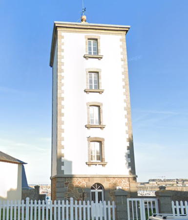
1865. Active; focal plane 20 m (66 ft); continuous green light, intensified on the range line. 19 m (62 ft) robust square cylindrical stone tower without lantern or gallery; the light is shown through a window on the top floor. Tower painted white with unpainted stone trim, except that the top floor of the front face is painted black. The rear light is the Phare de la Balue (next entry). (Ships approaching the old harbor of St.-Malo first follow an outer range, lining up the Phare du Grand Jardin with the Phare de la Balue. As they pass the Phare du Grand Jardin, the channel jogs to the right, and ships must then line up the Phare des Bas-Sablons and the Phare de la Balue.) Trabas has Capt. Peter's photo, Detienne has a page for the lighthouse, de Kleijn has a good photo, Guyomard and Carceller also have photos, Huelse has a historic postcard view, and Google has a street view and a satellite view. This is the only one of St.-Malo's four major lighthouses that survived World War II. Located on the Digue des Bas-Sablons on the old waterfront of St.-Malo. Site open, tower closed. . ARLHS FRA-343; FR-0542; Admiralty A1686; NGA 8000.
* La Balue (feu postérieur) (2)
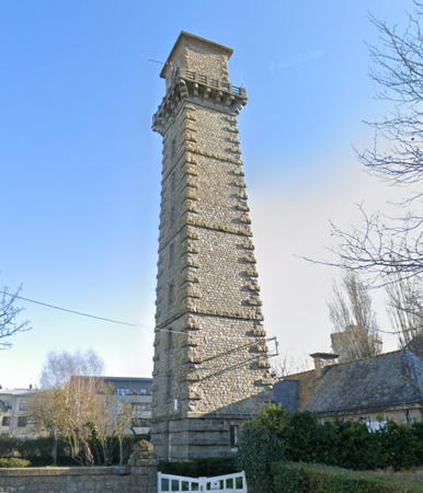
1948 (station established 1868). Active; focal plane 69 m (226 ft); continuous green light, intensified on the range line. 37 m (121 ft) robust square stone tower with gallery, attached to a 1-story stone keeper's house. The light is shown through a large circular window on the top floor. The tower is presently unpainted; historically the lighthouse was white with two black horizontal bands. DIRM's photo is at right, Trabas has a photo by Arno Siering), Detienne has a page for the lighthouse, and Google has a street view and a satellite view. This is the rear light for two ranges, one whose front light is the Phare des Bas-Sablons and another whose front light is the Phare du Grand Jardin. Like other St.-Malo lighthouses, this one was destroyed by German troops in August 1944 and rebuilt after the war. Huelse has a historic postcard view of the original lighthouse. Located on the Rue Douteleau, just off the Rue de la Balue, 1.65 km (1 mi) southwest of the front lighthouse. Site open, tower closed. . ARLHS FRA-178; FR-0543; Admiralty A1686.1; NGA 8004.

La Balue Light, Saint-Malo
DIRM photo
La Plate
Active; focal plane 11 m (36 ft); flash every 4 s, white, red or green depending on direction. 22 m (72 ft) round concrete tower with gallery, mounted on a large round concrete pier. Lighthouse painted black above the gallery and yellow below. Trabas has a closeup photo by Tom Chisholm and Bing has a satellite view. Located about 2.5 km (1.5 mi) off the east side of the entrance to St.-Malo. Accessible only by boat in rough seas. Site and tower closed. Admiralty A1675; NGA 7988.
* Rochebonne (Feu de la Haize) (feu postérieur) (2)
1951 (station established 1868). Active; focal plane 40 m (131 ft); continuous red light, intensified on the range line. 20 m (66 ft) robust square cylindrical Breton-style stone tower with gallery, attached to a 2-story stone keeper's house. The light is shown through a large octagonal window near the top of the tower. Below the gallery the front face of the tower is painted white, and above the gallery it is painted red. Philippe Simon's photo is at right, Detienne has a page for the lighthouse, Andreas Köhler has an excellent closeup photo, Guyomard and Carceller have several good photos, Trabas has Capt. Peter's photo, Olivier Fidalgo has a 2022 photo, Google has a distant street view, and the lighthouse is at the center of a Google satellite view. This is the rear light of a range that begins with the Phare du Grand Jardin. German troops destroyed this beautiful building in August 1944, but it was rebuilt carefully, on the original design, after the war. Located on the northeast side of St.-Malo, in Paramé. Site open, tower closed. . ARLHS FRA-453; FR-0536; Admiralty A1676.1; NGA 7984.
 

Rochebonne Light, Saint-Malo, October 2018
Google Maps photo by Philippe Simon

Cancale Lighthouses
Le Herpin (Pierre de Herpin)
1882. Active; focal plane 20 m (66 ft); white light, occulting twice every 6 s. 24 m (79 ft) round tapered stone tower with lantern and gallery, painted white; lantern and gallery are black. Fog siren (one long and one short blast every 60 s). Trabas has a photo by Thomas Philipp, Detienne has a page for the lighthouse, de Kleijn has an excellent photo, Guyomard and Carceller have a good photo by Joël Richard, Emmanuel Legros has a 2022 photo, Anthony Métayer has a view from shore, and Huelse has a historic postcard view, but the lighthouse is not seen in Bing's satellite view. The gallery was expanded in 1964 to accommodate the new fog signal; an earlier foghorn had been discontinued in 1954. Located on a waveswept rock northeast of the Pointe de Chemoulin, marking the entrance to the Baie du Mont Saint-Michel. Accessible only by boat in rough seas. Site and tower closed. . ARLHS FRA-049; FR-0523; Admiralty A1670; NGA 8012.
* La Houle sous Cancale (Feu de la Fenêtre) (1)
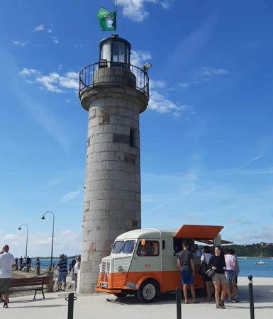
1863. Inactive since 1937. 11.5 m (38 ft) round stone tower with lantern and gallery. The lighthouse was originally painted white, but all the paint has faded from the tower; the lantern is black. Alexandrine Julian's photo is at right, de Kleijn has a good photo, Guyomard and Carceller have photos of the lighthouse and its replacement by Stéphane Longuet, Fouad Elmazouni has a nice photo of the stone tower on the waterfront, a 2008 photo is available, Arnaud Chapin has a closeup street view, Huelse has a historic postcard view, and Google has a street view and a satellite view. This lighthouse was built at the foot of the Jetée de la Fenêtre and was deactivated when the jetty was extended. It was replaced by a light at the end of the extended jetty (next entry). Located on the waterfront in Cancale, on the west side of the Baie du Mont Saint-Michel. Site open, tower closed. . ARLHS FRA-210.
* La Houle sous Cancale (Feu de la Fenêtre) (2)
1937. Active; focal plane 12 m (39 ft); green light, occulting three times every 12 s. 11 m (36 ft) square skeletal tower painted white and standing on a square 1-story equipment shelter. Trabas has Capt. Peter's photo, Russel Philippe has a 2020 photo, and Google has a satellite view. Located at the end of the extended jetty. Accessible by walking the pier. Site open, tower closed. Admiralty A1672; NGA 8016.

Information available on lost lighthouses:

Notable faux lighthouses:


La Houle Light, Cancale, August 2023
Instagram photo by Alexandrine Julian

Adjoining pages: North: Jersey | East: Basse-Normandie | West: Côtes d'Armor

Return to the Lighthouse Directory index | Ratings key

Posted July 29, 2005. Checked and revised October 15, 2023. Lighthouses: 12. Site copyright 2023 Russ Rowlett and the University of North Carolina at Chapel Hill.