Lighthouses of the United States: Georgia

The United States of America is a federal union of 50 states and a capital district. Located just north of Florida, the U.S. state of Georgia has a relatively short Atlantic coastline with six surviving historic lighthouses (3 active). The coastline is low, featuring a series of sandy islands known in Georgia as the Sea Islands. Savannah is the largest port in the state.

Although there is no state preservation society, there has been excellent public support in Georgia for lighthouse preservation. Three tall coastal towers have all been beautifully restored and additional National Park Service projects have saved the endangered Cockspur Island lighthouse.

Aids to navigation in the U.S. are maintained by the U.S. Coast Guard. However, the historic lighthouses in Georgia are all in private, state, or National Park Service ownership. Georgia navigational aids are the responsibility of the Coast Guard's Sector Charleston and its Aids to Navigation Team based at the Tybee Island Station.

Special thanks to Ron Schooling for his research on the marina lighthouses of northern Georgia.

ARLHS numbers are from the ARLHS World List of Lights; Admiralty numbers are from volume J of the Admiralty List of Lights & Fog Signals; USCG numbers are from Vol. III of the U.S. Coast Guard Light List.

General Sources
Georgia Lighthouses
Fine photos and descriptions by Kraig Anderson.
Beach Bum's Lighthouses: Georgia
This site by Stephen Wilmoth has accounts and photos of visits to most of the lighthouses.
Georgia, United States Lighthouses
Aerial photos posted by Marinas.com.
Online List of Lights - U.S. - Georgia
Photos by various photographers posted by Alexander Trabas; many of them were taken by Capt. Peter Mosselberger or Capt. Theo Hinrichs.
Lighthouses in Georgia (U.S. state)
Photos by various photographers available from Wikimedia.
Leuchttürme USA auf historischen Postkarten
Historic postcard images posted by Klaus Huelse.
U.S. Coast Guard Navigation Center: Light Lists
The USCG Light List can be downloaded in pdf format.
NOAA Nautical Charts
Nautical charts for the coast can be viewed online.
Navionics Charts
Navigation chart for Georgia.
 

Tybee Island Light
Tybee Island Light, Tybee Island, March 2013
Flickr Creative Commons photo by Doug Kerr

Atlantic Coast Lighthouses

Chatham County (Savannah Area) Lighthouses
Savannah, Georgia's oldest city, has a metropolitan population approaching 400,000. The city is located on the south side of the Savannah River, which forms the border between Georgia and South Carolina, about 20 mi (32 km) from the sea.
* [Savannah Harbor Range Rear (Beacon Range, Fig Island Range Rear (1), Old Harbor Light)]
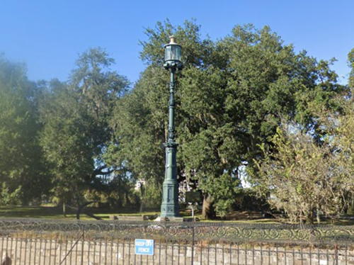
1858. Inactive since 1880 (a decorative gas light is displayed). Ornate 25 ft (7.5 m) cast iron tower, rather like a giant streetlight, painted dark green. Butch Petty has a 2009 photo with historical notes, Pedro Montes has a 2021 photo, Wikimedia has a historic photo, and Google has a street view (a portion is at right) and a satellite view. Although this structure is not a lighthouse by anyone's definition, it is a unique and historic beacon built by the U.S. Lighthouse Board. Originally it was the rear light of a range, the front light being on Fig Island downstream. Anderson has a page describing the history of the Fig Island Range lights. In 1880 the light was moved to the top of Old City Exchange Building, where it was shown until that building was demolished in 1904; it was then moved to a skeletal tower in the river. In 1999 the Savannah Morning News and CSX Real Property contributed $125,000 to restore the rusting 1858 tower as part of a larger city effort to spruce up historical monuments. The restoration began in August 2000 and the light was relit on 11 January 2001. Located in Savannah's Emmet Park, just off East Bay Street. Site open. Owner/site manager: City of Savannah. ARLHS USA-1387.
[Tybee Knoll Cut Range Front (3?)]
Date unknown (station established 1878). Active; focal plane 40 ft (12 m); quick-flashing white light. 40 ft (12 m) skeletal mast mounted on a square wood platform supported by piles. Trabas has a photo by Capt. Peter and Google has a satellite view. Wikipedia has a Coast Guard historic photo of the original lighthouse, a square cylindrical wood tower centered on a 1-story wood keeper's house. This lighthouse was replaced by a skeletal tower and demolished sometime in the late 1920s or early 1930s. The Tybee Knoll Cut is the first long reach through the Savannah River estuary for vessels arriving in the river. Located on the north side of Daymark Island in the Savannah River estuary. Site and tower closed, although the tower can be seen from nearby. Owner: U.S. Coast Guard. Site manager: U.S. National Park Service (Fort Pulaski National Monument). ARLHS USA-863; Admiralty J2792; USCG 3-4710.

Old Harbor Light, Savannah, October 2022
Google Maps street view
Tybee Knoll Cut Range Rear (3?)
Date unknown (station established 1878). Active; focal plane 23 m (75 ft); white light, 3 s on, 3 s off, visible only on or near the range line. 24 m (79 ft) square pyramidal skeletal tower with gallery. The tower carries a large rectangular daymark, colored red with a white vertical stripe. Trabas has a photo by Capt. Peter and Google has a satellite view. Located on the south side of Daymark Island in the Savannah River estuary. Site and tower closed, although the tower can be seen from nearby. Owner: U.S. Coast Guard. Site manager: U.S. National Park Service (Fort Pulaski National Monument). Admiralty J2792.1; USCG 3-4715.
Cockspur Island (2)
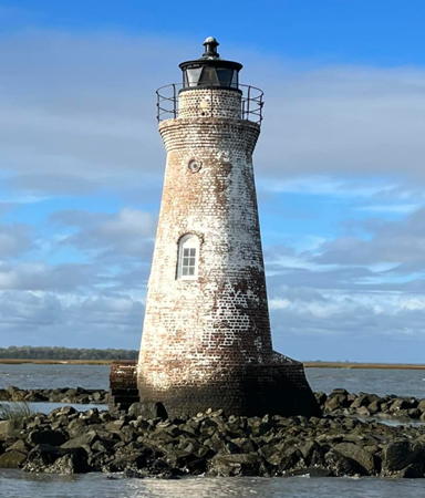
1857 (station established 1849). Reactivated (inactive 1909-2007, now maintained by the National Park Service); focal plane about 41 ft (12.5 m); white flash every 4 s. 46 ft (14 m) round brick tower with lantern and gallery, painted white. The keeper's house (formerly located at Fort Pulaski) has been destroyed. Dan Castleberry's photo is at right, the National Park Service has a page for the lighthouse, Trabas has Capt. Peter's photo, a 2022 photo is available, Allen Lewis has a 2016 photo, the Coast Guard has a historic photo, and Google has a satellite view. The original lighthouse was destroyed by a hurricane in 1854; the present tower is a reconstuction. Despite being transferred to the National Park Service in 1958 the lighthouse was greatly endangered by high water and years of neglect. Bryan Penberthy has a photo of the lighthouse before it was restored. A Park Service restoration project completed in 2000 added the replica lantern and addressed the tower's immediate problems, but it remained vulnerable to wave damage during hurricanes or other severe storms. Lighthouse Digest has Kwamme Anderson's August 2000 article on the restoration and Lynelle Mason's September 2003 article on the history of the light station. The park service relit the lighthouse in March 2007. Later in that year it was discovered that shipworms had invaded the foundation, threatening to topple the tower. The Park Service requested $1.4 million for a complete restoration. The Tybee Island Historical Society coordinated other fundraising efforts and the Friends of Cockspur Lighthouse organized to help save the lighthouse. In November 2008 the Georgia Trust for Historic Preservation placed the lighthouse on its Places in Peril list. In October 2012 the Corps of Engineers began installing a rip rap barrier to protect the lighthouse, and the park service was planning a more extensive restoration to begin when funds become available. In November 2015 the park service closed public access to the lighthouse due to safety concerns, and in 2016-17 it carried out a major restoration including repair of deteriorated mortar, interior repairs, and repainting. Another project in 2021 addressed continuing problems with the masonry and replaced the doors and windows with historically accurate fixtures. Kevin T. Akers has an October 2021 photo of the lighthouse surrounded by scaffolding. Located on a sandbar covered by water at high tide, on the north side of the entrance to the south channel of the lower Savannah River. Accessible only by boat, but there's a view from the Lighthouse Overlook Trail at Fort Pulaski. Site and tower closed. Owner: U.S. National Park Service. Site manager: Fort Pulaski National Monument. . ARLHS USA-181; Admiralty J2803.4; USCG 3-4661.
Cockspur Island Light
Cockspur Island Light, Savannah River, July 2007
Flickr Creative Commons photo by Dan Castleberry
**** Tybee Island (Range Rear) (4)
1867 (station established 1736). Active; focal plane 144 ft (44 m); continuous white light. 145 ft (44 m) tapered octagonal brick tower attached to workroom; upper and lower portions painted black, center white. The 1st order Fresnel lens has been in use since 1867. Doug Kerr's photo is at the top of this page, Anderson has a great page with many photos, Trabas has a good photo, Wikimedia has many photos, Udoy Datta has a 2022 photo, the Coast Guard has a historic photo, Marinas.com has aerial photos, Huelse has a postcard view, and Google has a street view and a satellite view. This light station, the oldest in the South and second oldest in the nation, was established less than four years after the colony of Georgia was founded. The lower section of the lighthouse incorporates 60 ft (18 m) of the 100 ft (31 m) octagonal tower built in 1773. A major restoration in 1998 restored the tower to its original appearance and its black and white 1916 daymark. This is a remarkably well preserved light station with three keeper's houses and other historic buildings; the restoration of these buildings is continuing. The 1881 principal keeper's house has been restored and furnished as a museum. The second assistant keeper's house was built in 1861 as a Confederate Army barracks. The brick summer kitchen, built in 1812, is the oldest building preserved. Ownership of the station was transferred to the Tybee Island Historical Society in 2002 under NHLPA. Windows and handrails were restored in early 2017. Repairs to lantern room and top of the tower were beginning in late 2023, and funds were being raised for repainting scheduled for 2024. The lighthouse is the rear light of the approach range for the Savannah River; the front light is on a square platform 1/2 mi (800 m) east of the lighthouse. Located on the south side of the Savannah River entrance, off US 80 in Tybee Island. Site and tower open daily except Tuesdays (admission fee for buildings). Owner/site manager: Tybee Island Historical Society . ARLHS USA-864; Admiralty J2776.1; USCG 3-0345.

McIntosh County Lighthouses
** Sapelo Island (1)
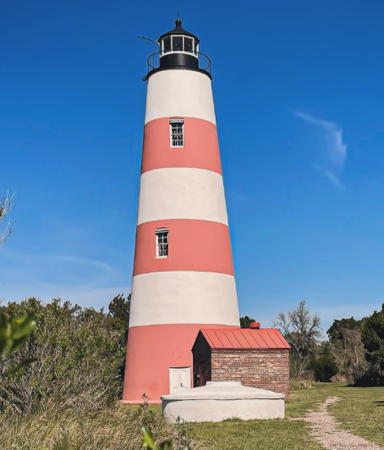
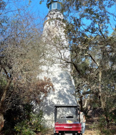
1820 (Winslow Lewis). Reactivated (inactive 1905-1998, now privately maintained and unofficial; charted as active by NOAA and Navionics); focal plane about 75 ft (23 m); white flash every 45 s. 65 ft (20 m) round old-style brick tower, painted with horizontal red and white bands; lantern and gallery painted black. The keeper's house has been demolished but the brick oil house (1890) survives. Larry Myhre's photo is at right, Damon Himes has a 2022 photo, a 2009 closeup is available, the National Archives has a historic photo, Marinas.com has aerial photos, and a Google satellite view is available. This is the nation's second-oldest brick lighthouse and the oldest survivor of Winslow Lewis's many lighthouse projects. The light was moved in 1905 to a pyramidal skeletal tower, which was deactivated in 1933 and relocated in 1934 to South Fox Island, Michigan. The original lighthouse was restored to its 1890 appearance in 1997-98 thanks to more than $200,000 in donations matched by federal and state grants. Matt Barnett has a 1990 photo showing how deteriorated the tower had become before the restoration. Additional restoration work was planned in 2020 in connection with the 200th anniversary of the lighthouse. The lighthouse formerly marked the entrance to Doboy Sound, but the entrance has migrated southward, making the light useless for navigation today. Located near the southern tip of Sapelo Island. The island is a nature reserve, accessible by passenger ferry Monday through Friday. Tours (reservations recommended) are available from the Sapelo Island Visitor Center in Meridian on Wednesdays and Saturdays all year and also on Fridays and on the last Tuesday of each month in the summer. Site and tower open. Owner: Georgia State Parks. Site manager: Sapelo Island National Estuarine Research Reserve. . ARLHS USA-738.
Sapelo Island Range Front (2)
1877 (range established 1868). Inactive since 1898. 25 ft (7.5 m) square pyramidal cast iron skeletal tower with enclosed square lantern room, painted white. Larry Myhre has a closeup photo, Kenneth Arbuckle has a 2015 photo, Michael Unruh has a 2021 closeup, and Google has a satellite view. The range was discontinued in 1899 after a hurricane in October 1898 had reshaped the entire area. The little tower survived and was used as an observation tower during World War II. Restored in 1997, it is a rare example of a once-common class of range lights. Located 200 yards (180 m) southeast of the 1820 lighthouse. Site open, tower closed. Owner: Georgia State Parks. Site manager: Sapelo Island National Estuarine Research Reserve. ARLHS USA-1014.

Sapelo Island Light
Sapelo Island Light, March 2013
Flickr Creative Commons photo by Larry Myhre


Glynn County (Brunswick Area) Lighthouses
Brunswick is a seaport with more than 100,000 residents. Its location at the head of the South Atlantic Bight makes it the westernmost city on the U.S. East Coast. The city is on a low peninsula on the west side of Saint Simons Sound; the entrance from the sea is between Saint Simons Island on the north and Jekyll Island on the south.
**** St. Simons Island (2)
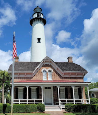
1872 (Charles Cluskey) (station established 1810) . Active; focal plane 104 ft (32 m); continuous white light with a more intense flash every 60 s. 104 ft (32 m) round brick tower, painted white. The original 3rd order Fresnel lens is in use. The unusual 2-story brick Victorian keeper's house is now the St. Simons Lighthouse Museum. Brick oil house (1890) and a Victorian gazebo also preserved. A photo is at right, Anderson has a fine page for the lighthouse, Trabas has Capt. Theo's photo, a 2022 photo is available, the Coast Guard has a historic photo, Marinas.com has aerial photos, Huelse has a historic postcard view, and Google has a street view and a satellite view. The lighthouse stands precisely on the entrance range line for St. Simons Sound, although it is not operated as a range light. This lighthouse replaced a 75 ft (23 m) early federal octagonal lighthouse built in 1810 and destroyed during the Civil War. The tower was restored in 1989-91 and again in 1997-98. On 26 May 2004 ownership of the lighthouse was transferred to the Coastal Georgia Historical Society under NHLPA. In late September 2009 the light was temporarily extinguished for several months of repairs and restoration. In February 2012 Glynn County received a $250,000 grant to restore the keeper's house. This was a key piece in raising $1.3 million to restore and endow the structure as the St. Simons Lighthouse Museum. In April 2021 metalworkers removed, repaired and replaced the ventilation ball atop the lantern. Located at the end of 12th Street off Beachview Street, on the southern end of St. Simons Island. Site and tower open daily (museum admission fee). Owner/site manager: Coastal Georgia Historical Society (St. Simons Lighthouse Museum ). ARLHS USA-805; Admiralty J2842; USCG 3-0520.
St. Simons South Tower
Date unknown. Active; focal plane 150 ft (46 m); red light, 3 s on, 3 s off, visible only along the approach to St. Simons Sound. 150 ft (46 m) square skeletal steel tower, painted white. Trabas has Darlene Chisholm's photo and Google has a satellite view. This tower and the companion north tower define the two sides of the St. Simons Entrance Channel. If both lights are visible vessels are in the channel; the St. Simons Island Light will then appear between them. We need information on the history of these towers. Located in St. Simons Sound off the west coast of St. Simons Island, about 500 ft (150 m) south southeast of the north tower. Accessible only by boat. Site open, tower closed. Admiralty J2843.2; USCG 3-6125.
St. Simons North Tower
Date unknown. Active; focal plane 150 ft (46 m); red light, 3 s on, 3 s off, visible only along the approach to St. Simons Sound. 150 ft (46 m) square skeletal steel tower, painted white. Trabas has Darlene Chisholm's photo and Google has a satellite view. Located in St. Simons Sound off the west coast of St. Simons Island. Accessible only by boat. Site open, tower closed. Admiralty J2843; USCG 3-6120.

Saint Simons Island Light, August 2011
Wikimedia Creative Commons photo by Ebyabe

Camden County Lighthouses
Little Cumberland Island
1838 (Joseph Hastings). Inactive since 1915 (a decorative light is now displayed and the tower is charted as a daybeacon). 60 ft (18 m) round old-style brick tower, painted white. The keeper's house and all other light station buildings were demolished in 1968. An aerial photo is also seen at right, Keith Murlless has a 2019 view from the sea, Dinh Tuan has a 2021 drone view, Marinas.com has aerial photos, the Coast Guard has a historic photo, and Google has a satellite view. The tower was renovated in 1994-98 but it needs a more thorough restoration; Sand dunes are migrating toward the light, and as a result the tower is now barely visible from the water. Endangered. In 2014-15 rapid beach erosion began to endanger the lighthouse and by the end of 2015 there was concern that it might be toppled within a few years. As a result the lighthouse was added to the Lighthouse Digest Doomsday List. Located on the north end of Little Cumberland Island. Site and tower closed; the island is privately owned and closed to the public. Owner/site manager: Little Cumberland Island Homes Association. ARLHS USA-439.
St. Mary's River Range A Rear
Date unknown. Active; focal plane 48 ft (15 m); white light, 3 s on, 3 s off. 48 ft (15 m) square skeletal tower mounted on a square platform supported by piles. The tower carries three rectangular daymarks colored red with a white vertical stripe. Trabas has a photo and Google has a satellite view. The St. Mary's River marks the border between Georgia and Florida. Located on the north side of the estuary near Point Peter. Accessible only by boat. Admiralty J2850.5; USCG 3-6695.

Little Cumberland Island Light, April 2005
Google Maps photo by ICEDOUTDRIPPIN
 

Inland Lighthouses

Lake Allatoona Lighthouses
Lake Allatoona is a large reservoir on the Etowah River near Cartersville, northwest of Atlanta. The lake is at an elevation of 840 ft (256 m).

*
Allatoona Landing
1980s. Active; focal plane 45 ft (14 m); flashing white light. 35 ft (10.5 m) round steel tower with a small lantern and gallery, painted white; lantern dome is green. A view from the lake is available and Google has a good satellite view. Located at a marina off Old Allatoona Road in Allatoona, on the southern arm of the lake near exit 283 of the I-75 expressway. Site open, tower closed. Owner/site manager: Allatoona Landing Marina.
* Park Marina Lake Allatoona
1980. Active; focal plane 70 ft (21 m); flashing white light. 40 ft (12 m) octagonal wood tower with lantern and gallery, attached to a 2-story marina office and store building. Lighthouse painted a light blue with darker blue trim. Karen Marr has a photo and Google has a satellite view. Located off Red Top Mountain Road across the lake from the Allatoona Dam. Site open, tower closed. Owner: Park Marina Allatoona Lake. Site manager: Red Top Mountain State Park.

Lake Lanier Lighthouses
Lake Lanier is a very large reservoir on the upper Chattahoochee River northeast of Atlanta. The lake is at an elevation of 1071 feet (326 m).

Aqualand
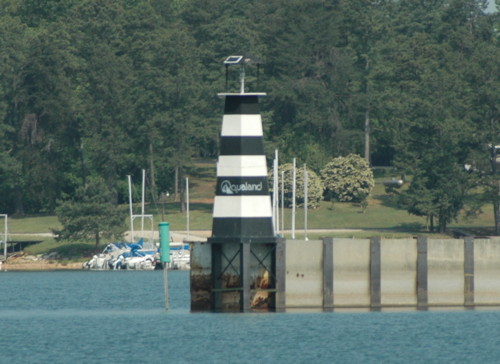
1997. Active; focal plane 31 ft (9.5 m); flashing white light. 25 ft (7.5 m) square steel tower, painted with black and white horizontal bands. Jason Fleming's photo is at right and Google has a satellite view. This light marks the end of a breakwall built for the 1996 Olympic Games, when this part of Lake Lanier was the site of the rowing competition. Located at the Aqualand Marina off Lights Ferry Road on the southeast side of the lake. Site open, tower closed. Owner/site manager: Aqualand Marina.
* Port Royale
2009. Active; focal plane 40 ft (12 m); flashing white light. 45 ft (14 m) octagonal wood tower with lantern and gallery, attached to a 2-1/2 story marina restaurant. DeElla Hoberg has a photo, the marina has a photo, and Google has a satellite view. Located at a marina off Brown's Bridge Road (GA 369) on the west central side of the lake. Site open, tower closed. Owner/site manager: Port Royale Lake Lanier.
Aqualand Light
Aqualand Light, Flowery Branch, May 2007
Flickr photo copyright Jason Fleming; used by permission

West Point Lake Lighthouse

West Point Lake is a large reservoir on the lower Chattahoochee River, extending for about 35 mi (56 km) above the city of West Point. Most of the lake is in Georgia, but some of the western shore is in Alabama. The lake is at an elevation of 625 ft (191 m).

*
Burnt Village (West Point Lake)
Date unknown. Active; light pattern unknown. Approx. 10 m (33 ft) hexagonal tower with lantern and gallery, painted with red and white horizontal bands. Mike Sussman has a photo, Leisa Epps has a 2016 photo, and Google has a satellite view. This lighthouse is on the Georgia side of the state line, but access to it is through Alabama. Located on the north side of the entrance to the Southern Harbor Marina, off Stateline Road about 5 km (3 mi) north of the West Point Dam. Site open, tower closed. Owner/site manager: Southern Harbor Marina.

Information available on lost lighthouses:

Adjoining pages: North: South Carolina | South: Florida East Coast

Return to the Lighthouse Directory index | Ratings key

Posted June 2004. Checked and revised August 15, 2023. Lighthouses: 15. Site copyright 2023 Russ Rowlett and the University of North Carolina at Chapel Hill.