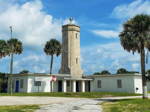
Lighthouses of the United States: Florida East Coast

The United States of America is a federal union of 50 states and a capital district. In the southeastern corner of the country most of the state of Florida occupies a long peninsula (about 500 mi (800 km) long and up to 160 mi (250 km) wide) separating the Atlantic Ocean from the Gulf of Mexico; the state's western "panhandle" extends westward along the Gulf coast. As a result Florida has by far the longest coastline of any state of the eastern United States. Nearly all of the coast is low and sandy, broken occasionally by narrow inlets leading to shallow lagoons. For visibility at a distance the Florida coast requires tall lighthouses.

Florida has about three dozen traditional lighthouses including several of the country's most famous light towers. The Florida Lighthouse Association (FLA) works for preservation of all the light stations. Nearly all the onshore stations are now supported by local lighthouse societies and FLA helped organize a Reef Lights Association to work for preservation of the offshore lights. Efforts of FLA and local associations have led to restoration projects undertaken or planned at most of the onshore lighthouses. Few states have worked as hard on lighthouse preservation as Florida in recent years.

This page includes lighthouses of Florida's Atlantic coast. Lighthouses of the Florida Keys and the west coast are on separate pages.

Navigational aids in the United States are operated by the U.S. Coast Guard, but ownership (and sometimes operation) of historic lighthouses has been transferred to local authorities and preservation organizations in many cases. Florida east coast lights are the responsibility of the Coast Guard's Seventh District, which includes Sector Jacksonville for the northern coast and Sector Miami for the southern coast.. Aids to Navigation Teams are stationed at Jacksonville and Ponce de Leon Inlet in Sector Jacksonville and at Fort Pierce and Fort Lauterdale in Sector Miami.

ARLHS numbers are from the ARLHS World List of Lights. Admiralty numbers are from volume J of the Admiralty List of Lights & Fog Signals. USCG numbers are from Volume III of the U.S. Coast Guard Light List.

General Sources
Florida Lighthouse Association
The association works hard for the preservation of lighthouses throughout the state and has encouraged the formation of a number of local preservation societies.
Florida Keys Reef Lights Foundation
This organization promotes the preservation of the six historic offshore lighthouses of the the Florida Keys.
Florida Lighthouses
Excellent photos and visitor accounts for the lighthouses, posted by Kraig Anderson.
Lighthouses in Florida
Photos by various photographers available from Wikimedia.
Florida, United States Lighthouses
Aerial photos posted by Marinas.com.
Online List of Lights - U.S. - Atlantic Coast
Photos by various photographers posted by Alexander Trabas.
Lighthouses of Florida
Photos and information from Stephen Wilmoth's "Beach Bum" web site.
Florida Maritime Heritage Trail - Lighthouses
A site posted by the Florida Division of Historical Resources; it has photos and brief accounts for all the lighthouses of the state, with visitor information.
Florida Lighthouses
This site by Bill Britten of the University of Tennesee has some outstanding photos.
Lighthouses of Florida
A site by Bryan Penberthy with photos of many of the lighthouses including some of the offshore lights.
Leuchttürme USA auf historischen Postkarten
Historic postcard images posted by Klaus Huelse.
U.S. Coast Guard Navigation Center: Light Lists
The USCG Light List can be downloaded in pdf format.
NOAA Nautical Charts
Nautical charts for the coast can be viewed online.
Navionics Charts
Navigation chart for Florida.
 

Ponce Inlet Light
Ponce de Leon Inlet Light, Ponce Inlet, March 2011
Wikimedia Creative Commons photo by Ebyabe


Hillsboro Inlet Light, Pompano Beach, January 2010
Wikimedia Creative Commons photo by Jordon Kalilich

First Coast (North Coast) Lighthouses

Nassau County Lighthouses
St. Mary's Entrance Range Rear
Date unknown. Active; focal plane 95 ft (29 m); white light, 3 s on, 3 s off, visible on and near the range line. 95 ft (29 m) square skeletal tower mounted on a large platform supported by piles. The tower carroes a rectangular daymark colored red with a white vertical stripe. Trabas has a photo and Google has a satellite view. The St. Mary's River marks the border between Georgia and Florida. Located in the mouth of Tiger Creek inside the entrance. Accessible only by boat. Admiralty J2850.1; USCG 3-6530.
** Amelia Island
1838 (Winslow Lewis; reconstruction of the Great Cumberland Island light, built in 1820 on the Georgia side of the St. Marys River). Active; focal plane 107 ft (32.5 m); white flash every 10 s (red sector covering shoals in Nassau Sound). 64 ft (19.5 m) round stucco-clad old-style brick tower, painted white; 3rd order Fresnel lens (1903). A photo is at right, there is an official page for the lighthouse, Trabas has a photo, Maria Rominger has a 2021 photo, the Coast Guard has a historic photo, Marinas.com has aerial photos, and Google has a satellite view. The historic keeper's house was demolished in the 1960s after being replaced by modern Coast Guard housing (1950). The brick oil house survives. The lighthouse has a granite spiral stairway, very unusual for a Southern lighthouse. A preservation group, Amelia Lighthouse and Museum, Inc., works for restoration and public access. The city of Fernandina Beach took ownership of the light station in March 2001. In 2002 the state granted $350,000 for restoration, and in 2004 the restoration was carried out by the International Chimney Corporation. Additional restoration work was completed in 2008 and in 2009 the architects received an award from the Florida Trust for Historic Preservation. In March 2017 a bullseye section of the Fresnel lens came out during cleaning and the light was deactivated pending repairs. Located north of Atlantic Avenue in Fernandina Beach. Site open 11 am to 2 pm on Saturdays, and the base of the tower is open to tours from the Atlantic Recreation Center on the first and third Wednesday mornings of each month; tickets must be purchased at least a day in advance. Owner/site manager: City of Fernandina Beach. . ARLHS USA-010; Admiralty J2856; USCG 3-0565.

Duval County (Jacksonville Area) Lighthouses
St. Johns Bar Cut Range Rear
Date unknown. Active; focal plane 80 ft (24 m); white light, 3 s on, 3 s off, visible only along the range line. 80 ft (24 m) triangular skeletal tower mounted on a 1-story equipment shelter on a square platform supported by piles. Trabas has a photo and Google has a satellite view. This is an entrance range for the St. Johns River. Located in a wetland area about 1.25 mi (2 km) northwest of Mayport. Site open, tower closed. Owner: U.S. Coast Guard. Site manager: U.S. National Park Service (Timucuan Ecological and Historic Preserve). Admiralty J2859.1; USCG 3-7120.

Amelia Island Light, Fernandina Beach, October 2015
Wikimedia Creative Commons photo by bubba73
* Fulton Cutoff Range Rear
Date unknown. Active; focal plane 106 ft (32 m); white light, 3 s on, 3 s off, visible only along the range line. 102 ft (31 m) triangular skeletal tower; the tower carries a daymark colored red with a white vertical stripe. Trabas has a photo and Google has a street view and a satellite view. This is the rear light of a downstream (eastbound) range that guides vessels through a cut below Jacksonville. Located at the edge of a marsh near Ramoth and Milton Drives, off FL 105 in the Little Marsh area. Site probably open, tower closed; there should also be a view from Fort Caroline on the other side of the estuary. Owner/site manager: U.S. Coast Guard. Admiralty J2862.1; USCG 3-7355.
Trout River Cut Range Front
Date unknown. Active; focal plane 70 ft (21 m); quick-flashing red light, visible only along the range line. 70 ft (21 m) square skeletal tower mounted on a square platform supported by piles and carrying a rectangular daymark colored red with a white vertical stripe. Trabas has a photo and Google has a satellite view. Located at an oil terminal on the St. Johns River east of the Jacksonville Zoo. Site and tower closed. Admiralty J2863.5; USCG 3-7530.
Trout River Cut Range Rear
Date unknown. Active; focal plane 94 ft (29 m); red light, 3 s on, 3 s off, visible only along the range line. 89 ft (27 m) square skeletal tower carrying a rectangular daymark colored red with a white vertical stripe. Trabas has a photo and Google has a satellite view. Located 315 yd (288 m) north northeast of the front light. Site and tower closed. Admiralty J2863.51; USCG 3-7535.
St. Johns River (Mayport) (3)
1859 (station established 1830). Inactive since 1929. 81 ft (24.5 m) round brick tower, extended from 66 ft (20 m) in 1887 by expanding the top of the tower and adding a taller lantern. Tower painted bright red, watch room white; the lantern is black with a greenish metallic roof. During World War II the Navy raised the ground level so that the tower now appears to be about 65 ft (20 m) tall; the door is buried and access to the tower is through a window. A photo is at right, Mary Snyder has a 2022 photo, Wikimedia has several photos, Wilmuth's page has good photos, Penberthy's site has an excellent closeup photo by Katja Thomas, Huelse has a historic postcard view, and Google has a street view and a satellite view. The Mayport Lighthouse Association was formed in the 1990s in hopes of restoring the lighthouse and opening it to the public. In January 2000 the association reached an agreement with the Navy to use a nearby building as a visitor center and museum, but the base has been closed to the public for security reasons since the 9/11 attacks in 2001. Efforts to obtain a state grant for restoration were not successful during 2004. The Association disbanded, but in 2021 it was revived and efforts to involve the Navy in assessing the condition of the lighthouse and working toward restoration and public access are underway. In 2023 there were plans to move the lighthouse to a waterfront location open to the public, if funding can be found. Located about 2 miles (3 km) inland and 1/4 mi (400 m) southeast of the St. John's River Ferry terminal in Mayport. Site and tower closed, but there's a good view from Broad and Palmer Streets just outside the naval station fence. Owner/site manager: U.S. Naval Air Station Jacksonville. . ARLHS USA-796.

St. Johns River Light, Mayport, January 2011
Wikimedia Creative Commons photo by Ebyabe
Mayport Basin Range Front
Date unknown. Active; focal plane 69 ft (21 m); quick-flashing green light. Approx. 62 ft (19 m) slender square skeletal tower carrying a rectangular daymark colored red with a white vertical stripe. Trabas has a photo by Capt. Peter Mosselberger and Google has a satellite view. The range guides U.S. Navy vessels into the Mayport Basin. Located on the waterfront at the west end of the basin. Site and tower closed. Owner: U.S. Coast Guard. Site manager: U.S. Naval Air Station Jacksonville. Admiralty J2860; USCG 3-7155.
Mayport Basin Range Rear
Date unknown. Active; focal plane 91 ft (28 m); green light, 3 s on, 3 s off. Approx. 85 ft (26 m) slender square skeletal tower carrying a rectangular daymark colored red with a white vertical stripe. Trabas has a photo by Capt. Peter Mosselberger and Google has a satellite view. Located at the west end of the basin, 98 yd (90 m) west of the front light. Site and tower closed. Owner: U.S. Coast Guard. Site manager: U.S. Naval Air Station Jacksonville. Admiralty J2860.1; USCG 3-7160.
St. Johns
1954. Active; focal plane 83 ft (25 m); four white flashes every 20 s (there is also a flashing red aerial obstruction light). 64 ft (19.5 m) octagonal cylindrical white cement block tower, unpainted; small cylindrical lantern; VRB-25 aerobeacon (1998). Original keeper's house (barracks) now used by the Coast Guard for offices. Jay Vizcarra's photo is at right, the Lighthouse Association also has a page for the lighthouse, Trabas has a photo by Capt. Peter Mosselberger, Kenneth Arbuckle has a 2016 photo, the Coast Guard has a 1955 photo, and Google has a satellite view. Located off Seminole Road and Oakhill Street, about 1 mile south of St. Johns River entrance in Mayport. Site and tower closed; there is a distant view from Kathryn Abbey Hanna Park south of the naval station. Owner: U.S. Coast Guard. Site manager: U.S. Naval Air Station Jacksonville. ARLHS USA-795; Admiralty J2858; USCG 3-0575.

St. Johns Light, Mayport, September 2020
Google Maps photo by Allen Forrest

St. Johns County (St. Augustine Area) Lighthouse
**** St. Augustine (2)
1874 (Paul J. Pelz, architect). Station established 1823. Active (privately maintained); focal plane 161 ft (49 m); continuous white light with a more intense flash every 30 s. 165 ft (50 m) round brick tower painted in a black-and-white spiral similar to Cape Hatteras Light; lantern painted red; original rotating 1st order Fresnel lens. Sibling of Bodie Island, North Carolina. 2-story brick and wood Victorian keeper's house (rebuilt after being gutted by fire in 1970). Donna McCraw's photo is at right, Anderson has a fine page for the lighthouse, Wikimedia has numerous photos, Trabas has a photo, Marinas.com has aerial photos, Huelse has a historic postcard view, and Google has a street view and a great satellite view. This lighthouse replaced a 1737 Spanish watch tower that was converted to a lighthouse in 1823. Judging from a National Archives photo and Huelse's postcard view it appears this was done by adding a new section atop the original tower. The old tower collapsed due to beach erosion in 1880. The present light station has been meticulously restored to its 1888 appearance. Lighthouse Digest has an article on the restoration of the lens after it was damaged by a vandal in 1987. A new visitor center opened in October 2000; the tower was painted and the gallery restored by International Chimney. In May 2001 a lightning strike did $10,000 in damage to computers and electrical equipment at the tower. In 2002 the lighthouse was one of the first to be transferred under the National Historic Lighthouse Preservation Act. During Hurricane Frances in 2004 museum operations director Rick Cain valiantly kept the light on. In 2008-09 the exterior of the lantern was restored and its windows were replaced. In 2014 the museum paid $150,000 to purchase the keeper's house and the rest of the light station property, which had been leased previously from St. Johns County. In 2014-15 the lens and its rotating mechanism were cleaned and restored in place. In April 2015 the museum launched a crowdfunding campaign and sold T-shirts to complete the $280,000 needed for repainting and repairs to the tower. In 2016 work began to restore two Coast Guard buildings, a garage and a barracks, for expansion of exhibits on the station's history during World War II. This project was completed in 2018. In September 2017 the Maritime Archaeology and Education Center opened in new buildings on the light station grounds. The tower was repainted inside and out in 2021. Located on Lighthouse Ave. at Carver St., off FL A1A less than a mile southeast of the Lions Bridge in St. Augustine. Site and tower open daily (admission fee). Owner/site manager: St. Augustine Lighthouse and Maritime Museum . ARLHS USA-789; Admiralty J2866; USCG 3-0590.

St. Augustine Light, August 2006
Flickr photo
copyright Donna McCraw; used by permission

Central Coast Lighthouses

Volusia County (Daytona Beach Area) Lighthouse
**** Ponce de Leon Inlet (Mosquito Inlet) (2)
1887. Reactivated (inactive 1970-1982, now privately maintained); focal plane 159 ft (48.5 m); six white flashes in 15 s followed by 15 s eclipse. 175 ft (53 m) brick tower, red washed exterior; lantern painted black; 3rd order Fresnel lens (in use 1933-1970 and since 2004). The light station museum includes 3 original keeper's houses, pump house, oil house, and a modern Fresnel lens exhibit hall featuring a variety of lenses, beacons, and lighthouse artifacts. The original 1st order Fresnel lens (1887-1933) and Cape Canaveral's original 1st order Fresnel lens (1860) are on display. A photo is at the top of this page, Anderson has an excellent page with good photos, Wikimedia has numerous photos, Trabas has a closeup photo, Marinas.com has aerial photos, the Coast Guard has a historic photo, Huelse has a postcard view, Jason Perrone has a closeup street view, and Google has a satellite view. This is the second tallest brick lighthouse in the United States. An earlier lighthouse was constructed on the opposite side of the Inlet in 1835 but was never activated and was destroyed by a storm the following year. The Town of Ponce Inlet took ownership of the lighthouse after the Coast Guard moved the light to a skeletal tower in 1970. The light was returned in 1982 when a high-rise condominium blocked the light of the skeletal tower. International Chimney Corporation carried out $1.14 million in tower renovations and repairs during 2000-01. Among other repairs, the gallery was replaced, windows were replaced or reconditioned, and the brickwork was restored. In 2003 the tower's 1st order and 3rd order Fresnel lenses were restored and in April 2004 the 3rd order Fresnel lens was returned to service in the tower. In 2019 the Preservation Association paid $1.7 million to buy the Pacetti House, a historic house and sometime inn across the street; workers stayed there while the lighthouse was being built. Recognized as a National Historic Landmark, this is also one of the most complete light station museums in the nation. Located on South Peninsula Drive in the town of Ponce Inlet, south of Daytona Beach. Site and tower open daily (admission fee). Owner: Town of Ponce Inlet. Site manager: Ponce de Leon Inlet Lighthouse Preservation Association . ARLHS USA-644; Admiralty J2877; USCG 3-0610.

Brevard County (Cape Canaveral Area) Lighthouses
** Cape Canaveral (2)
1868 (station established 1848). Active; focal plane 137 ft (42 m) ; two white flashes every 20 s, flashes separated by 5 s. 151 ft (46 m) tapering cast iron tower (brick lining), painted with black and white horizontal bands. The original 1st order Fresnel lens, removed in 1993, is on display at the Ponce de Leon Inlet lighthouse museum. It was replaced by a DCB-224 aerobeacon and then by an LED beacon in 2021. The keepers' houses were demolished in 1967 but the brick oil house survives and one of the keeeper's houses has been reconstructed. Wikimedia has several photos including the one at right, Spencer Hedlund has a 2022 photo, a good 2007 photo is available, Trabas has a distant view, Marinas.com has aerial photos, Huelse has a historic postcard view, Jason Perrone has a street view, and Google has a fine satellite view. Cliff Lethbridge has posted a history of the light station, Lighthouse Digest published Alan Headley's article on it in October 2000, and the Digest has Jeremy D'Entremont's story on life at the station early in the Space Age. The lighthouse was relocated farther from the beach in 1894 but the original foundation survives near Launch Complex 46. The lighthouse was renovated by the Coast Guard in 1995-97; the original copper lantern roof, removed during that project, was preserved as the roof of a gazebo at the Air Force Space and Missile Museum. In December 2000 the light station was transferred from the Coast Guard to the Air Force. In the summer of 2001 the Cape Canaveral Lighthouse Foundation was formed, and in 2002 the Foundation and the Air Force agreed to work for restoration and public access. In 2003 the dilapidated oil house was restored and planning began for restoration of the tower. In December 2005 an agreement with the Air Force was signed, allowing the foundation to manage the site and offer public tours. In early 2006 a major $750,000 restoration was underway. In spring 2007 the restoration was nearing completion as the lantern roof was returned to the lighthouse; work was completed by May. In January 2008 the Air Force discovered that the soil around the lighthouse was contaminated by lead from paint chips; the lighthouse was closed for a time while this danger was assessed. In 2011 a fund drive began to rebuild the station's two keeper's houses, and in 2014 plans for the reconstruction were submitted for Air Force approval. For several years the Air Force offered guided tours of the tower but the tours were suspended in 2013 due to budget restrictions. In 2015 the Foundation reached agreement with the Air Force to resume tours beginning in January 2016. In October 2017 the Brevard County Commission voted to allocate $500,000 in tourism development funds for reconstruction of one of the station's keeper's houses. The 150th anniversary of the lighthouse was celebrated in February 2018. The reconstruction of the the keeper's house was completed in July 2019 and the house is now the Canaveral Lighthouse Museum. In 2023 a 4th order Fresnel lens used at the lighthouse shortly after the Civil War was placed on display. Located near the Cape, about 1 mile (1.5 km) inland. Site closed except for the guided tours. During summer 2019 tours were offered at least once a week but the day of the week varied. Tours depart from the Exploration Tower in Port Canaveral; they include visits to several launch sites and the Space Force Space and Missile Museum. Because the light station is within a high-security area reservations are required at least 48 hours in advance and participants must provide photo IDs and full identification; visitors are subject to approval by the Air Force. Owner: U.S. Space Force (Patrick Space Force Base). Site manager: Cape Canaveral Lighthouse Foundation . ARLHS USA-108; Admiralty J2888; USCG 3-0625.
Cape Canaveral Light
Cape Canaveral Light, November 2011
Wikimedia Creative Commons photo by Danielrener
Canaveral Harbor Approach Range Rear
Date unknown. Active; focal plane 86 ft (26 m); white light, 3 s on, 3 s off, visible only on the range line. 75 ft (23 m) triangular skeletal tower. No photo available but Google has an indistinct satellite view. Located beside Samuel Phillips Parkway on the south side of the Range Operations Control Center. Site and tower closed. Owner: U.S. Coast Guard. Site manager: Patrick Space Force Base. Admiralty J2890.1; USCG 3-9580.
* Port Canaveral Range Rear (2)
2016(?). Active; focal plane 54 ft (16.5 m); green light, 3 s on, 3 s off, visible only on the range line. 50 ft (15 m) square skeletal tower. Trabas has Rainer Arndt's photo of the light in action and Google has a 2021 street view and a satellite view. The street view also shows the former light near the left edge; it's not clear if it has been removed since. Located on the north side of the cut through the barrier island providing access to the port facilities, near the south (main) gate of the Cape Canaveral Air Force Station. Site status unknown but the light is easily seen from the airbase entrance or from the Bee Line Expressway (FL 528). Owner: U.S. Coast Guard. Site manager: Patrick Space Force Base. Admiralty J2891.1; USCG 3-9635.

St. Lucie County Lighthouse
Fort Pierce Entrance Range Rear
Date unknown. Active; focal plane 50 ft (15 m); green light, 3 s on, 3 s off. 50 ft (15 m) triangular skeletal tower mounted on a square platform supported by piles and carrying a rectangular daymark colored red with a white vertical stripe. Trabas has a photo and Bing has a satellite view. Located north of the channel at the inside end of the inlet. Accessible only by boat. Site open, tower closed. Admiralty J2910.1; USCG 3-9825.

Gold Coast (South Coast) Lighthouses

Palm Beach County Lighthouses
**** Jupiter Inlet
1860 (George G. Meade) Active; focal plane 146 ft (44.5 m); two white flashes every 30 s, flashes separated by 7.7 s. 105 ft (32 m) brick tower, painted brick red; lantern painted black. The original rotating 1st order Fresnel lens remains in use. The principal keeper's house burned in 1927, but there is a small museum in the oil house. A photo is at right, Anderson's page has good photos and a historical account, Trabas has a photo, a 2022 drone view is available, Marinas.com has excellent aerial photos, David Hager has a closeup street view, and Google has a satellite view. This lighthouse is the oldest building in Palm Beach County. The state and Coast Guard carried out a major renovation of the tower during 1999-2000, during which archaeologists discovered the light is built on an Indian mound. Lighthouse Digest has Gini McKain's story on the restoration and the history of the light station. In August 2004 the tower was closed to climbing to replace about 50 stairway brackets; it reopened late in the year. However, Hurricane Jeanne sandblasted the paint from the upper portion of the tower, and in October 2005 the light was temporarily extinguished for repairs. It reopened in December. In 2008 the light station and its surroundings were designated an Outstanding Natural Area, and in 2009 the lighthouse received $1 million in federal stimulus funding, roughly half for lighthouse maintenance and improvements and half for habitat restoration in the natural area. The 150th anniversary of the lighthouse was celebrated in January 2010. In May 2017 the lighthouse closed for a month while the lantern roof was replaced. Ownership of the light station was transferred from the Coast Guard to the Bureau of Land Management in 2019. In 2020 BLM offered three of four modern Coast Guard housing units for use by nonprofit organizations; the fourth will renovated for public restrooms. Two former Coast Guard barracks will be demolished to make way for a replica of the Weather Bureau building destroyed in 1928′s Okeechobee Hurricane. Located on the east side of US 1 and the north side of Jupiter Inlet. Site and tower open to guided tours daily January through April and daily except Mondays the rest of the year (admission fee); closed on major holidays. Owner: U.S. Bureau of Land Management (Jupiter Inlet Lighthouse Outstanding Natural Area). Site manager: Jupiter Inlet Lighthouse and Museum . ARLHS USA-411; Admiralty J2922; USCG 3-0725.
Lake Worth Entrance Range Rear
Date unknown. Active; focal plane 55 ft (17 m); white light, 3 s on, 3 s off, visible only on the range line. 55 ft (17 m) triangular skeletal tower. Trabas has a photo and Google has a satellite view. Lake Worth is the name of the lagoon behind West Palm Beach. The light guides vessels entering Lake Worth Inlet, an artificial inlet leading to the Port of Palm Beach. Located on Peanut Island, a Palm Beach County park. Accessible only by boat, but there is a good view from Peanut Island and from both sides of Lake Worth Inlet. Owner/site manager: U.S. Coast Guard. Admiralty J2926.1; USCG 3-10190.

Jupiter Inlet Light
Jupiter Inlet Light, November 2010
Wikimedia Creative Commons photo by Ebyabe


Broward County (Fort Lauderdale Area) Lighthouses
** Hillsboro Inlet
1907. Active; focal plane 136 ft (41.5 m); white flash every 20 s (not visible from the land side). 137 ft (42 m) octagonal pyramidal skeletal tower with central cylinder; lantern and upper half of tower painted black, lower half white. The original rotating 2nd order Fresnel lens remains in use. One of only three surviving towers of this design. The original 1-1/2 story wood keeper's house and other light station buildings survive, but an assistant keeper's house was demolished in 2005 despite loud protests from preservationists. Jordan Kalilich's photo is at the top of this page, Anderson has a good page for the lighthouse, Wikimedia has several photos, Trabas has a photo by Capt. Theo Hinrichs, Scott Graham has a 2021 photo, the Florida Archives has a historic photo, Marinas.com has aerial photos, and Google has a beach view and a satellite view. The light station is used as a recreation area for senior military personnel. The Fresnel lens was relit in August 2000 after much hard work to replace the rotating mechanism of the light. In 2003 the gallery was restored. In March 2012 a museum and visitor center for the lighthouse opened on the south side of the inlet in Hillsboro Inlet Park, and in May the Coast Guard repainted the lighthouse. Also in 2012 the Coast Guard asked for comment on whether the light should be extinguished to protect sea turtles nesting in the area. Comment was not favorable and the light remained in service. In September 2017 storm surge from Hurricane Irma partially undermined the foundation of the lighthouse; it was estimated that $500,000 would be needed to armor the site and repair the damage. In 2023-24 a project will replace windows, doors, and electrical wiring, and repaint the lighthouse. Located on the beach, protected by a riprap jetty, on the north side of Hillsboro Inlet. Site closed (land access is controlled by the private Hillsboro Club), tower closed except for guided tours usually offered once a month. The museum is open 11 am to 3 pm Wednesday through Sunday year round except for a vacation period in August. There's a good view from Pompano Beach's Hillsboro Inlet Park on the south side of the inlet, and the lighthouse is also visible from the FL A1A bridge over the inlet. Owner: U.S. Coast Guard. Site manager: Hillsboro Lighthouse Preservation Society . ARLHS USA-372; Admiralty J2934; USCG 3-0775.
* Port Everglades Range Front
Date unknown. Active; focal plane 85 ft (26 m); continuous green light visible only on the range line. 80 ft (24 m) triangular skeletal tower. The tower also carries a rectangular daymark painted red with a white vertical stripe. Trabas has a photo by Capt. Peter Mosselberger and Google has a street view and a satellite view. Port Everglades is a major port at Fort Lauderdale, including a large cruise ship terminal, petroleum storage facilities, and a container ship facility. Access to the crowded port area is through a deep, short cut in the barrier island. Located at the foot of Pier 2, at Eisenhower and Spangler Boulevards in Fort Lauderdale. Site open, tower closed. Owner: U.S. Coast Guard. Site manager: Port Everglades. Admiralty J2938; USCG 3-10320.
* Port Everglades Range Rear
Date unknown. Active; focal plane 135 ft (41 m); continuous green light visible only on the range line; the tower also carries fixed and flashing directional lights that provide precise information to the pilots of arriving ships. Approx. 120 ft (37 m) triangular skeletal tower. The tower also carries a rectangular daymark painted red with a white vertical stripe. Trabas has a photo by Capt. Peter Mosselberger and Google has a street view and a satellite view. Located on the north side of Spangler Boulevard (SE 24th Street) a short distance east of Federal Highway (US 1) in Fort Lauderdale, about 1/2 mi (850 m) west of the front light. Site open, tower closed. Owner: U.S. Coast Guard. Site manager: unknown. Admiralty J2938.1; USCG 3-10325.

Dade County (Miami Area) Lighthouses
Miami Main Entrance Range Rear (2)
Date unknown. Active; focal plane 49 ft (15 m) white light, 3 s on, 3 s off; there is also a passing light, white flash every 4 s. 49 ft (15 m) square skeletal tower mounted on a square platform supported by a single steel pile. In Trabas's photo this light is on the left next to an earlier version supported by tripod piles. Google has an indistinct satellite view. This is actually the approach range; ships approach from the northeast and turn westward as they near this light. Located off Fisher Island, southeast of Miami Beach. Accessible only by boat. Site open, tower closed. Admiralty J2948.1; USCG 3-10465.
Government Cut Range Rear (2)
Date unknown. Active; focal plane 50 ft (15 m) green light, 3 s on, 3 s off; there is also a passing light, white flash every 2.5 s. 50 ft (15 m) square skeletal tower mounted on a square platform supported by a single steel pile. Trabas's photo shows an earlier version supported by four piles. Google has an indistinct satellite view. This range guides vessels departing Miami. Located about 1.8 mi (3 km) east of the Entrance Range Rear Light. Site open, tower closed. Admiralty J2948.41; USCG 3-10510.
 
*** Cape Florida (2)
1846 (Leonard Hammand). Station established 1825. Reactivated (inactive 1878-1978 and 1990-1996, now operated by the State of Florida); focal plane 95 ft (29 m); white flash every 6 s. 95 ft (29 m) round tapering old-style brick tower (raised from 65 ft (20 m) in 1855); 300 mm lens (1996). Lighthouse painted white, lantern and watch room black. The 1-1/2 story brick keeper's house and other station buildings are replicas built in 1970. The lantern in use in the 1870s is displayed near the entrance to the station. Leonard DeFrancisci's photo is at right, Wikimedia has additional photos, Trabas has Michael Boucher's photo, Huelse has a historic postcard view, the Florida Archives has a 1901 photo of the lighthouse, which was abandoned at that time, and Google has a street view and a satellite view. This light station is Florida's oldest; the original tower was gutted by fire during an attack by Seminole Indians in 1836. The present lighthouse was battered by hurricanes and gravely endangered by beach erosion prior to the construction of a stone revetment by the Corps of Engineers in 1968; the revetment was repaired after Hurricane Andrew in 1992. The lighthouse is considered secure, but it remains very close to the water. The tower was thoroughly renovated in 1996-99 and was repainted in 2008. Located at the southern tip of Key Biscayne. Park and light station open daily (entry fee); the light station buildings and tower are open to guided tours (no additional fee) at 10 am and 1 pm Thursday through Monday. Owner: State of Florida. Site manager: Bill Baggs Cape Florida State Park. . ARLHS USA-118; Admiralty J2956.4; USCG 3-0923.
Cape Florida Light
Cape Florida Light, December 2009
Wikimedia Creative Commons photo by Leonard J. DeFrancisci
Fowey Rocks
1878. Active; focal plane 110 ft (33.5 m); white flash every 10 s (two red sectors cover dangerous reefs to north and south). 110 ft (33.5 m) octagonal pyramidal wrought iron screwpile tower with octagonal 2-story Empire style keeper's house on a central platform, solar-powered VRB-25 aerobeacon. Tower and lantern painted brown; central cylinder and keeper's house white. The original Henry Lepaute 1st order Fresnel lens is on display at the Coast Guard Training Center in Yorktown, Virginia. The station also has an array of weather instruments as a NOAA C-MAN station. A photo is at right, Giovanni Calzadilla has a closeup photo, another closeup photo is available, Trabas has Rainer Arndt's distant view, Huelse has a historic postcard view, the Coast Guard has a historic photo, and Google has a satellite view. In 2011 the lighthouse became available for transfer under NHLPA and the Florida Keys Reef Lights Foundation announced its intention to apply for ownership. However, the lighthouse was withdrawn later from the NHLPA process and in October 2012 it was transferred directly to the National Park Service. In 2015 it was recognized by the Florida Trust for Historic Preservation as one of the 11 most endangered historic sites in the state. Located on a dangerous reef southeast of Key Biscayne, within the boundaries of Biscayne National Park. Accessible only by boat; the lighthouse is distantly visible from Cape Florida. Site open, tower closed. Owner: U.S. National Park Service. Site manager: Biscayne National Park. . ARLHS USA-307; Admiralty J2960; USCG 3-0920.
[Boca Chita]
Around 1940. Inactive but charted as a daybeacon. 65 ft (20 m) round coral stone tower with lantern and gallery. The lighthouse is unpainted. Wikimedia has photos, Jon Hall has a nice photo, Robert Carinci has a 2022 photo, the National Park Service has a page for the key and the lighthouse, Chris Saum has a closeup street view, and Google has a satellite view. This lighthouse was built by Mark Honeywell, who owned Boca Chita Key from 1937 to 1945. He intended it to be an active light but the Coast Guard ordered it extinguished as soon as it was lit. The island and lighthouse were incorporated into Biscayne National Park when the park was established in 1980. The tower has been restored in recent years; in 2013 the dome was restored and equipped with hurricane-proof glass. As the only tall structure on the Biscayne reef it has always been a conspicuous daybeacon and it serves now as a popular observation point. The Biscayne National Park Institute offers tours to Boca Chita on the first Saturday of each month. Otherwise accessible only by boat. Located on the west side of Boca Chita Key, about 10 mi (16 km) south of Key Biscayne. Site open, tower usually open October through March. Owner: U.S. National Park Service. Site manager: Biscayne National Park. .

Fowey Rocks Light, June 2019
Google Maps photo by Captain Wilson

Lighthouses of Inland Lakes

Lake George Lighthouse
[Volusia Bar]
1885. Light inactive since 1916; fog signal inactive since 1943. Charted as an obstruction. The 1-1/2 story square screwpile lighthouse burned in 1974. Foundation pilings remain visible. Google has a satellite view. After deactivation the historic lighthouse remained in service for some time as a fog signal building; later it was sold and renovated as a private residence. The building burned in 1974. Lake George (also called Lake Welaka) is Florida's second largest lake. Located on the west side of the upper St. Johns River entrance on the south side of Lake George, about 3 miles (5 km) northwest of Astor. Accessible only by boat. Site open. ARLHS USA-869.

Lake Tohopekaliga Lighthouse
* Kissimmee
1999. Active (privately maintained); focal plane 25 ft (7.5 m); rotating white light. 22 ft (6.5 m) round red brick tower with lantern and gallery; lantern painted black. Rian Castillo has a closeup photo, another closeup photo is available, Andrew Montgomery has a street view, and Google has a satellite view. This light is on Lake Tohopekaliga, a large lake in Osceola County linked by canals to several other area lakes. Located at the end of an artificial peninsula extending into the lake in Kissimmee's Lakefront Park, about 1/4 mi (400 m) northeast of the marina. Site open, tower closed. Owner/site manager: City of Kissimmee. .

Lake Dora Lighthouse
* Mount Dora
1988. Active (privately maintained); flashing red light. 35 ft (11 m) stucco-covered brick tower with hexagonal lantern and gallery, painted with horizontal red and white bands. A 2021 photo is at right, Donna McCraw has an excellent closeup photo, and Google has a satellite view and a distant street view. The lighthouse was built with citizen contributions. Located on Grantham Point, in Gilbert Park at the south end of Tremain St. on the northeast side of Lake Dora in Mount Dora, about 25 miles (40 km) northwest of Orlando. Site open, tower closed. Owner/site manager: City of Mount Dora. .

Mount Dora Light, Mount Dora, October 2021
Wikimedia Creative Commons photo by Jokergirloftheworld

Information available on lost lighthouses:

Notable faux lighthouses:

Adjoining pages: North: Georgia | East: Bahamas | South: Florida Keys | West: Florida West Coast

Return to the Lighthouse Directory index | Ratings key

Posted 2000. Checked and revised August 21, 2023. Lighthouses: 27. Site copyright 2023 Russ Rowlett and the University of North Carolina at Chapel Hill.