Lighthouses of Guinea

The Republic of Guinea (Guinée in French) is the former French Guinea, located on the southern curve of West Africa northwest of Liberia and Sierra Leone. Mostly inland, it has a relatively short coast between Sierra Leone and Guinea-Bissau. Colonized by France in the late 1890s, it was one of the first European colonies in Africa to become independent, in 1958. Like its neighbors Guinea has suffered frequently from political turmoil at home or in adjoining countries. The one important port, Conakry, is also the national capital; it is one of largest cities of West Africa with a population nearing 3.5 million. Guinea is the world's second-largest producer of bauxite, the raw material for aluminum.

French is the official language of government and commerce in Guinea. The French word for a lighthouse is phare, although a smaller light or harbor light is called a feu (literally "fire," but here meaning "light") or a balise (beacon). In French île is an island, cap is a cape, pointe is a promontory or point of land, roche is a rock, récife is a reef, baie is a bay, estuaire is an estuary or inlet, détroit is a strait, rivière is a river, and havre is a harbor.

Aids to navigation in Guinea are maintained by the Ports and Warerways Section (Section Ports et Voies Navigables) of the Merchant Marine Directorate (Direction Nationale De La Marine Marchande De Guinée), an agency of the transport ministry. Almost no information on lighthouses is available, so visitor accounts and photos would be very welcome.

ARLHS numbers are from the ARLHS World List of Lights. Admiralty numbers are from volume D of the Admiralty List of Lights & Fog Signals. U.S. NGA List numbers are from Publication 113.

General Sources
Phares d'Afrique
Photos posted by Alain Guyomard and Robert Carceller as part of their Phares du Monde web site.
World of Lighthouses - Guinea
Photos by various photographers available from Lightphotos.net.
Online List of Lights - Guinea
Photos by various photographers posted by Alexander Trabas.
Afrikanische Leuchttürme auf historischen Postkarten
Historic postcard images posted by Klaus Huelse.
Google Maps
Satellite view of Guinea's coastline.


Île Tamara Light, Conakry, October 2021
ex-Google Maps photo by Nataliya Dorokhova

Kindia Region Lighthouse
Île Matakong (?)
1902. Active (?); focal plane 21 m (69 ft); white light, 2 s on, 2 s off. 12 m (39 ft) "white tower," according to NGA. No photo available. Google has a satellite view that probably shows the station; if so the light tower is on the roof of a station building. Located on an island connected by a narrow isthmus to the mainland just north of the entrance to the Forécariah estuary, about 50 km (30 mi) southeast of Conakry. Site status unknown. ARLHS GUN-002; Admiralty D3096; NGA 24648.

Conakry Region Lighthouses
The Port of Conakry is exposed at the end of the narrow Kaloum Peninsula, so for protection the harbor is surrounded by breakwaters.

* Boulbinet (Boulbiné, Conakry)
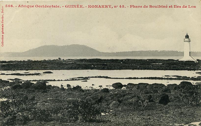
1906. Reactivated; focal plane 13 m (43 ft); white or red light, depending on direction, occulting twice every 12 s. 12 m (39 ft) round masonry tower wih lantern and gallery mounted on a circular concrete base. Tower painted white, lantern and gallery red. Kurt Cotoaga's photo is at right, a very distant 2020 view is available, and Google has an indistinct satellite view. Guyomard and Carceller have Véronique Nolet's photo showing the original appearance of the lighthouse and a 2006 photo is also available. Thereafter the lighthouse was abandoned and its lantern was removed; Murray Crawford has a 2012 photo and Lightphotos.net has a February 2016 photo. The Admiralty reported the light "temporarily extinguished" in 2011 and listed it as reactivated in February 2017, although the lighthouse still looks abandoned in a December 2018 view by Aguibou Doudou Touré. Cotoaga's photo at right was posted by the Explanders travel site in January 2025 and shows the lighthouse restored, presumably by the Albayrak Group, a Turkish conglomerate that signed a contract to manage the port in 2018. The lighthouse serves as a leading light, its white sector shining along the line of approach from the southeast. Huelse has a historic postcard view. Located at the end of a breakwater just off the tip of the peninsula in Conakry. Accessible only by boat. Site open, tower closed. ARLHS GUN-001; Admiralty D3093; NGA 24636.
Wharf No. 12
Date unknown. Active; focal plane about 12 m (39 ft); green flash every 3 s. 8 m (26 ft) round cylindrical concrete tower, upper 2/3 painted green. A photo is below right and Google has an indistinct satellite view. This light and the next one frame the entrance to the harbor, between the waterfront and the breakwater. Located at the southwestern tip of the peninsula. Site and tower closed. Admiralty D3094.5; NGA 24638.

Boulbinet Light, Conakry, ca. 2024
ex-Explanders.com photo by Kurt Cotoaga
Dique de la Prudente
Date unknown. Active; focal plane 13 m (43 ft); six very quick white flashes followed by one long white flash every 10 s. 11 m (36 ft) square cylindrical skeletal tower. The center of the tower is surrounded by a hexagonal vertically slatted daymark, the upper part painted yellow and lower part black. No photo available but Google has a satellite view. Located at the end of the breakwater of Conakry, about 1 km (0.6 mi) northwest of the Boulbinet lighthouse. Accessible only by boat. Site status unknown. Admiralty D3094; NGA 24640.
Île Tamara
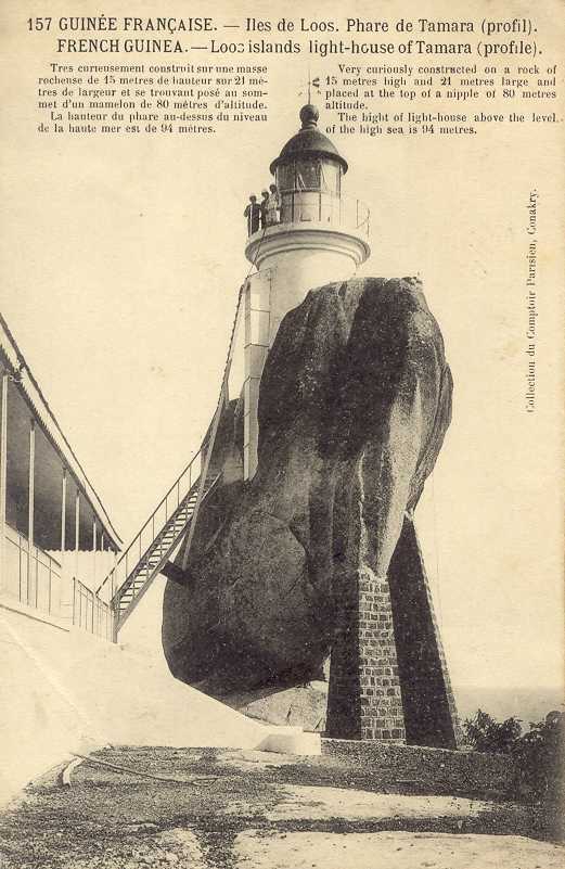
1906. Active; focal plane 95 m (311 ft); white flash every 5 s. Approx. 10 m (33 ft) masonry tower with lantern and gallery. Lighthouse painted white, lantern and gallery red. Nataliya Dorokhova's 2021 photo is at the top of this page, Tom Davis has a 2019 photo, has a 2018 closeup, the French Navy posted a 2008 photo, Huelse has a historic postcard view, and a Google satellite view shows the station. Several recent photos (no longer online) showed visitors on the gallery. Although the lighthouses appears in poor condition there is a modern LED optic inside the lantern. The lighthouse is built cleverly atop a giant boulder, the lava plug of an extinct volcano; the boulder and tower together must be at least 25 m (82 ft) in height. This was intended as the landfall light for Conakry, and the light has a listed range of 48 km (30 mi). Murray Crawford reports that the light was operating in August 2012. Île Tamara is the outermost island of the Îles de Los, about 20 km (13 mi) southwest of Conakry. The islands were a British possession from 1818 to 1904, when Britain traded them for French concessions of fishing rights off Newfoundland and Labrador. Arranged in a circle, the islands are the caldera rim of a long-dead volcano. Located on a steep bluff on the southwest side of the island. Accessible only by boat. Site apparently open, tower status unknown. ARLHS GUN-003; Admiralty D3090; NGA 24620.

Wharf No.12 Light, Conakry, ca. 2024
Vesseltracker.com photo

Boké Region Lighthouses
[Cap Verga]
Date unknown. Inacive but still listed by NGA. 10 m (33 ft) mast. No photo available but Google has a satellite view of the station. Cap Verga is a prominent cape about 130 km (80 mi) northwest of Conakry. Located on heights about 5 km (3 mi) north of the point of the cape. Site status unknown. ex-Admiralty D3088; NGA 24616.
[Cap Gonzalez]
Date unknown. Active; focal plane 10 m (33 ft); three white flashes every 15 s. 10 m (33 ft) "white column," according to NGA. Bing's satellite view shows what appears to be a post with gallery mounted on a concrete pier. No photo available. Located on a shoal off the cape, about 40 km (25 mi) northwest of Cap Verga. Accessible only by boat. Site open, tower closed. Admiralty D3087; NGA 24612.

Information available on lost lighthouses:

Notable faux lighthouses:

Adjoining pages: North: Guinea-Bissau | South: Sierra Leone

Return to the Lighthouse Directory index | Ratings key

Posted September 5, 2005. Checked and revised August 6, 2026. Lighthouses: 5. Site copyright 2026 Russ Rowlett and the University of North Carolina at Chapel Hill.