Lighthouses of Sierra Leone

The Republic of Sierra Leone, a former British colony, is located between Guinea and Liberia on Africa's west coast. Freetown is the capital and the only commercial port. Independent since 1961, the country was torn by a decade-long civil war in the 1990s. Following an end to the fighting in 2002 a UN peacekeeping force helped bring some stability to the country. Port facilities were mostly destroyed during the war but they have been restored with help from the World Bank and other international agencies.

Navigational lights in Sierra Leone are the responsibility of the Sierra Leone Maritime Administration. We need current information on the status of the country's signature lighthouse.

ARLHS numbers are from the ARLHS World List of Lights. Admiralty numbers are from volume D of the Admiralty List of Lights & Fog Signals. U.S. NGA List numbers are from Publication 113.

General Sources
World of Lighthouses - Sierra Leone
Photos by various photographers available from Lightphotos.net.
Online List of Lights - Sierra Leone
Photos by various photographers posted by Alexander Trabas.
Afrikanische Leuchttürme auf historischen Postkarten
Historic postcard images posted by Klaus Huelse.
Navionics Charts
Navigation chart for Sierra Leone.
Lighthouses
* Cape Sierra Leone (Aberdeen) (1)
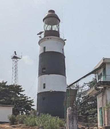
1849. May be active but not listed by the Admiralty; focal plane 19 m (62 ft); white light, pattern unknown. 21 m (69 ft) round masonry tower with lantern and gallery, painted white. Jamal Othman has the 2021 photo at right showing a lamp in the lantern and two solar panels on the gallery. Gravely endangered. The lighthouse was abandoned and deteriorating for many years. Its light was replaced by a "temporary" light on a nearby water tower. When David Vaucher visited in 2004 he found scaffolding around the tower and solar panels on the gallery, but the light was not on in 2005. When Reto Müller visited in February 2011 there was no lens in the lantern and the main light was not working, but the red light was in service and two keepers were on duty. Dominique Fofanah has a 2019 photo, Frank-Andreas Lönnig has a November 2010 photo, T.K. Biggs has a distant 2001 photo, Lightphotos.net has two photos, Miles Snowdon has a photo taken in 1973-74, and Google has a satellite view. Huelse has a postcard view and the lighthouse was featured on a 1950s postage stamp (also posted by Huelse). Built by Chance Brothers, this historic lighthouse is one of West Africa's oldest lights. Reactivation of the tower was announced in the Admiralty Notices to Mariners in April 2010 but the listing was dropped in January 2015. Located at the point of the cape, on the south side of the entrance to the harbor of Freetown, the capital of Sierra Leone. Accessible by road from Freetown or on foot from nearby resort hotels. Site apparently open, tower presumably closed. Operator: Sierra Leone Maritime Administration. ARLHS SIE-001; ex-Admiralty D3098; ex-NGA 24656.
#Cape Sierra Leone (2)
Around 1980. Probably removed. Approx. 22 m (72 ft) cylindrical water tower with a large square tank at the top. David Vaucher's 2004 photo is at right and Simon Boots has a 2016 aerial view, but the tower is no longer seen in Google's satellite view. In the absence of the main light the water tower served as a beacon for ships entering the Sierra Leone River, displaying a continuous red light. Located 460 m (0.3 mi) south of the original lighthouse. Site status unknown.
[Ferry Terminal (Government Wharf) (3?)]
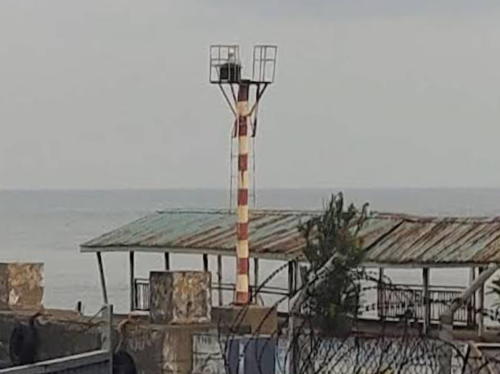
Date unknown. Active; focal plane about 16 m (52 ft); red light, pattern unknown. Approx. 14 m (46 ft) steel mast painted with red and white horizontakl bands. Zeeshan Mehmood has a 2023 photo and Google has a satellite view. NGA describes a continuous green light on the square platform seen near the left edge of the satellite view; this light may still exist. Michel Forand has a postcard view of an older light on the Government Wharf and Huelse has posted the same postcard view. Located at the Government Wharf adjacent to the ferry terminal in downtown Freetown. Site status unknown. Listed light: Admiralty D3098.5; NGA 24664.
Queen Elizabeth II Quay East End
Date unknown. Active; focal plane 28 m (92 ft); green light flashing in groups of three, period not listed. Approx. 25 m (82 ft) square industrial building; its function is not known. No photo available but Google has a satellite view. Located at a corner of the quay. Site and tower closed. Admiralty D3100.2; NGA 24672.

Information available on lost lighthouses:


Cape Sierra Leone Light, Freetown, March 2021
Google Maps photo by Jamal Othman


"Temporary" Cape Sierra Leone Light, Freetown, 2004
photo copyright David Vaucher; used by permission

Adjoining pages: North: Guinea | South: Liberia

Return to the Lighthouse Directory index | Ratings key

Posted September 5, 2005. Checked and revised April 18, 2024. Lighthouses: 3. Site copyright 2024 Russ Rowlett and the University of North Carolina at Chapel Hill.