Lighthouses of Guatemala: Caribbean Coast

The Republic of Guatemala is the northwesternmost and most populous country of Central America, bordering Mexico, Belize, Honduras, and El Salvador. The country has a coastline about 250 km (150 mi) long facing south on the Pacific Ocean and a short coastline facing northeast on the Gulf of Honduras, the southwestern arm of the Caribbean Sea. The principal ports include Puerto Quetzal (San José) on the Pacific and Puerto Barrios on the Gulf of Honduras. This page is for lights on the Caribbean coast and there is a separate page for those of the Pacific coast.

In Spanish the word for a lighthouse is faro, baliza is a beacon, isla is an island, cabo is a cape, punta is a promontory or point of land, péñon is a rock, arrecife is a reef, bahía is a bay, ría is an estuary or inlet, estrecho is a strait, río is a river, and puerto is a port or harbor.

Aids to navigation in Guatemala are the responsibility of the national port authority, the Comisión Nacional Portuaria.

ARLHS numbers are from the ARLHS World List of Lights. Admiralty numbers are from volume J of the Admiralty List of Lights & Fog Signals for Caribbean lights and from volume G for Pacific lights. Light List numbers are from NGA Publication 110.

General Sources
Online List of Lights - Guatemala Atlantic
Photos by Capts. Theo Hinrichs ("Capt. Theo") and Peter Mosselberger ("Capt. Peter"), posted by Alexander Trabas.
World of Lighthouses - Guatemala
Photos by various photographers available from Lightphotos.net.
Lighthouses in Guatemala
Photos by various photographers available from Wikimedia.
GPSNavigationCharts
Navigation chart information for Guatemala.
Navionics Charts
Navigation chart information for Guatemala.


Cabo Tres Puntas Light, Puerto Barrios, February 2019
Flickr photo copyright Luis A. Hernández S.; permission requested

Izabal Department Lighthouses
[Ox Tongue Shoal]
Date unknown. Active; focal plane about 6 m (20 ft); white flash every 3 s. 6 m (20 ft) square skeletal tower mounted on a square platform supported by piles. Wikimedia has a closeup photo by Dennis Jarvis and Trabas has a photo by Capt. Theo but the light is not seen in Bing's satellite view. This light marks the west end of a long shoal extending into the Bahía de Amatique, the bay at the extreme southwestern corner of the Caribbean Sea. The listed focal plane is 4 m (13 ft) but the captain's photos show that the light is a twin of the Heredia Shoal light (next entry). Accessible only by boat. Site open, tower closed. Admiralty J5982; NGA 16420.
[Heredia Shoal]
Date unknown. Active; focal plane 6 m (20 ft); red flash every 3 s. 6 m (20 ft) square skeletal tower mounted on a square platform supported by piles. Trabas has a photo by Capt. Theo but the light is not seen in Bing's satellite view. This light marks the edge of shoals on the south side of the Bahía de Amatique. Accessible only by boat. Site open, tower closed. Admiralty J5984; NGA 16419.
Matias de Galvez (Puerto Santo Tomás de Castilla) Range Front
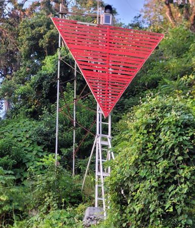
Date unknown. Active; focal plane 11 m (36 ft); quick-flashing yellow light. 10 m (33 ft) skeletal mast painted white and carrying a large white triangular daymark, point up. Trabas has Capt. Peter's photo (also seen at right) and Google has an indistinct satellite view. NGA desribes the daymark as being red; apparently the color was changed sometime after 2016. Located on the waterfront of the naval base and container terminal in Puerto Barrios, next to the cruise ship terminal. Site and tower closed but the light can be seen from approaching ships. Admiralty J5989; NGA 16412.
Matias de Galvez (Puerto Santo Tomás de Castilla) Range Rear
Date unknown. Active; focal plane 24 m (80 ft); occulting yellow light. 10 m (33 ft) skeletal mast painted white and carrying a large white triangular daymark, point down. Trabas has Capt. Peter's photo and Google has an indistinct satellite view. NGA desribes the daymark as being red and it is indeed red in Google's 2016 street view. Located on a hillside 347 m (380 yd) south of the front light. Site and tower closed but the light can be seen from the Calle de la Playa behind the naval headquarters. Admiralty J5989.1; NGA 16416.
Puerto Barrios
Date unknown. Active; focal plane unknown; white flash every 8 s. Approx. 25 m (82 ft) triangular skeletal communications tower painted with red and white horizontal bands. Trabas has Capt. Peter's photo, and Google has a street view and an indistinct satellite view. Located on a low hill about 1.6 km (1 mi) east southeast of the main quay in Puerto Barrios. Site status unknown. Admiralty J5985; NGA 16418.
Cabo Tres Puntas
Date unknown. Active; focal plane 40 m (131 ft); white flash every 3 s. 39 m (128 ft) square skeletal tower with gallery. Luis A. Hernández S. has the 2019 photo seen at the top of this page, Trabas has a view frpm the sea by Capt. Theo, and Google has an indistinct satellite view. Located about 2.5 km (1.5 mi) east of the tip of the peninsula sheltering the bay of Puerto Barrios, near the village of Santa Inés Chicar. Site status unknown. ARLHS GUL-001; Admiralty J5992; NGA 16424.

Puerto Santo Tomás Range Front Light, Puerto Barrios
photo copyright Capt. Peter Mosselberger; used by permission
 

Information available on lost lighthouses:

Adjoining pages: North: Belize | East: Honduras | South: Guatemala Pacific

Return to the Lighthouse Directory index | Ratings key

Posted October 31, 2008. Checked and revised April 8, 2024. Lighthouses: 4. Site copyright 2024 Russ Rowlett and the University of North Carolina at Chapel Hill.