Lighthouses of Guatemala: Pacific Coast

The Republic of Guatemala is the northwesternmost and most populous country of Central America, bordering Mexico, Belize, Honduras, and El Salvador. The country has a coastline about 250 km (150 mi) long facing south on the Pacific Ocean and a short coastline facing northeast on the Gulf of Honduras, the southwestern arm of the Caribbean Sea. The principal ports include Puerto Quetzal (San José) on the Pacific and Puerto Barrios on the Gulf of Honduras. This page is for lights on the Pacfic coast and there is a separate page for those of the Caribbean coast.

Aids to navigation in Guatemala are the responsibility of the national port authority, the Comisión Portuaria Nacional.

In Spanish the word for a lighthouse is faro, baliza is a beacon, isla is an island, cabo is a cape, punta is a promontory or point of land, péñon is a rock, arrecife is a reef, bahía is a bay, ría is an estuary or inlet, estrecho is a strait, río is a river, and puerto is a port or harbor.

ARLHS numbers are from the ARLHS World List of Lights. Admiralty numbers are from volume G of the Admiralty List of Lights & Fog Signals. NGA numbers are from NGA Publication 111.

General Sources
Online List of Lights - Guatemala Pacific
Photos by Capt. Peter Mosselberger posted by Alexander Trabas.
World of Lighthouses - Guatemala
Photos by various photographers available from Lightphotos.net.
Central American Lighthouses
Photos by Larry Myhre.
Navionics Charts
Navigation chart for Guatemala.

Puerto Quetzal Range Front Light
Entrance Range Front Light, Puerto Quetzal, May 2012
Flickr Creative Commons photo by Larry Myhre

Escuintla Department Lighthouses
Puerto Quetzal (Giratorio, San José)
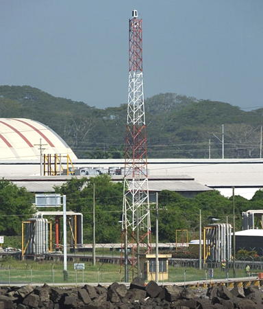
Date unknown. Active; focal plane 30 m (98 ft); two white flashes every 5 s. Approx. 28 m (92 ft) triangular skeletal tower painted with red and white horizontal bands. Trabas has Capt. Peter's photo, the light is on the right in Makiko Narumi's panoramic view of the harbor, and the shadow of the tower is seen in Google's satellite view. NGA lists this as an aviation light but there is no airport nearby; the light appears to function as the landfall light for the port. Puerto Quetzal is Guatemala's principal port on the Pacific; its dredged harbor has replaced the open roads of nearby Puerto San José. The port serves both commercial traffic and cruise ships. Located just to the east of the harbor entrance. Site status unknown. Admiralty G3386.6; NGA 15363.5.
Puerto Quetzal Radar
Date unknown. Active; focal plane about 33 m (108 ft); light characteristic unknown (listed only as "lit"). Approx. 30 m (98 ft) square cylindrical skeletal tower painted with red and white horizontal bands. Trabas has Capt. Peter's photo and Google has a satellite view. Located in the rear of the harbor facilities. Site status unknown. Admiralty G3386.9.
Puerto Quetzal Water Tank
Date unknown. Active (?); focal plane 29 m (95 ft); white flash every 4 s. Approx. 25 m (82 ft) square skeletal tower carrying a round water tank. Tower and tank painted red. Google has a satellite view. The tower seems to be missing its lens in Capt. Peter's photo. Located a short distance northwest of the harbor. Site status unknown. Admiralty G3387.
Puerto Quetzal Entrance Range Front
Date unknown. Active; focal plane 13 m (43 ft); quick-flashing white light. Approx. 10 m (33 ft) square skeletal tower with gallery, painted white. The front of the tower carries a rectangular daymark, red with a white vertical stripe. Myhre's photo is at the top of this page, Trabas has Capt Peter's photo, the light is at the left edge of a distant drone view, and Google has a satellite view. Located in a picnic area on the west side of the harbor entrance. Site open, tower closed. Admiralty G3385; NGA 15361.
Puerto Quetzal Entrance Range Rear
Date unknown. Active; focal plane 18 m (59 ft); white light occulting once every 4 s. Approx. 16 m (52 ft) square skeletal tower with gallery, painted red. The tower carries a long rectangular daymark, red with a white vertical stripe. Trabas has Capt Peter's photo, Myhre has a 2012 photo, a distant drone view is available, and Google has a satellite view. Located on the south shore of the harbor. Site open, tower closed. Admiralty G3385.1; NGA 15361.5.
Puerto San José (2?)
Date unknown (station established 1890). Active; focal plane 28 m (92 ft); white light, 10 s on, 10 s off. Round red water tank atop a warehouse. Trabas has Capt. Peter's photo and Google has a street view and a satellite view. Puerto San José, a town of about 25,000 residents, was Guatemala's principal Pacific port until the development of Puerto Quetzal. The original light was "displayed from the cupola of Government House." Located just off the waterfront about 3 km (2 mi) west of Puerto Quetzal. Site status unknown. ARLHS GUL-002; Admiralty G3390; NGA 15356.

San Marcos Department Lighthouses
* Ocos Range Front
Date unknown. Active; focal plane 15 m (49 ft); white flash every 4 s. Approx. 12 m (39 ft) square cylindrical concrete tower with lantern and gallery, attached to a 1-story equipment building. Lighthouses painted with vertical blue and white stripes (the color pattern of the Guatemalan flag); lantern painted red. Anton Jensen has a view from the rear light and Google has a street view and a satellite view. This range marks Guatemala's border with Mexico; the border follows the Río Suchiate just west of the lighthouses. Located about 200 m (220 yd) southeast of the Mexican border at Los Faros (The Lighthouses), about 5 km (3 mi) west of Ocos. Site open, tower status unknown. Admiralty G3397; NGA 15354.
* Ocos Range Rear
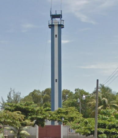
Date unknown. Active; focal plane 29 m (95 ft); white flash every 4 s. Approx. 24 m (79 ft) square cylindrical concrete tower with lantern and gallery, attached to a 1-story equipment building. Anton Jensen has photo and Google has the street view seen at right and a satellite view. Located about 350 m (380 yd) northeast of the front light. Site open, tower status unknown. Admiralty G3397.5; NGA 15354.5.

Ocos Range Rear Light, September 2016
Google Maps street view

Information available on lost lighthouses:

Adjoining pages: North: Guatemala: Caribbean | Southeast: El Salvador | Northeast: Mexico South Coast

Return to the Lighthouse Directory index | Ratings key

Posted October 31, 2008. Checked and revised October 24, 2023 Lighthouses: 8. Site copyright 2023 Russ Rowlett and the University of North Carolina at Chapel Hill.