Lighthouses of the United Kingdom: Scotland's Western Isles

The United Kingdom (officially the United Kingdom of Great Britain and Northern Ireland) includes England, Scotland, Wales, and Northern Ireland. Occupying the northern third of the island of Great Britain, the kingdom of Scotland has shared its monarch with England since 1603 and has been part of the United Kingdom since 1707. The coastline of the country is deeply cut by inlets, and there are more than 790 islands. The country has a long and distingushed maritime history; many of the most famous British captains and navigators have been Scots.

This page covers lighthouses of the Western Isles of Scotland, often called the Outer Hebrides (Na h-Eileanan Siar in Scottish Gaelic). The islands extend in a chain from north northeast to south southwest, separated from the Highlands mainland and from the Isle of Skye in the Inner Hebrides by a sound called The Minch and from the southern Inner Hebrides by a bay called the Sea of the Hebrides. The largest islands are Lewis and Harris (actually a single island), North Uist, and South Uist.

Scotland was divided historically into 34 counties; the counties no longer have any administrative function although they continue to have cultural significance. Since 1996 the country has been divided into 32 council areas for the purposes of local government. Until 1975 Lewis was in the county of Ross and Cromarty and the rest of the islands were in Inverness-shire. In 1975 the islands were united in a unitary council area called Comhairle nan Eilean Siar. The council area is also a lieutenancy area, one of the areas used for the ceremonial lord-lieutenants, the monarch's representatives. Its population is about 27,000.

The islands are accessible by air or by Caledonian MacBrayne ferries from various locations in western Scotland. The four light stations reasonably accessible without a boat are all on or close to the Isle of Lewis, which is accessible by ferry from Ullapool in the northern Highlands or from Uig on the Isle of Skye.

The Northern Lighthouse Board manages all the lighthouses of the Western Isles except for the harbor lights of Stornoway, the largest town of the islands.

Scottish Gaelic is commonly spoken in the islands. The Scottish Gaelic phrase for a lighthouse is taigh solais; eilean is an island, sgeir is a skerry or rock, and rubha or àird is a cape or promontory.

ARLHS numbers are from the ARLHS World List of Lights. Admiralty numbers are from Volume A of the Admiralty List of Lights & Fog Signals. U.S. NGA numbers are from Publication 114.

General Sources
Northern Lighthouse Board - Lighthouse Library
The Board's web site includes information and photos for many of the lighthouses.
Michael's Comprehensive List of Scottish Lights
Data and photos posted by Michael Spencer. Section S covers Lewis and Harris and Section T covers the rest of the Western Isles.
Lighthouse Archives
Lighthouse information from LighthouseAccommondations.uk.
Online List of Lights - Scotland
Photos by various photographers posted by Alexander Trabas.
Lighthouses in Scotland, United Kingdom
Aerial photos posted by Marinas.com.
Lighthouses in the Outer Hebrides
Photos available from Wikimedia; many of these photos were first posted on Geograph.org.uk.
World of Lighthouses - Scotland
Photos by various photographers available from Lightphotos.net.
Britische Leuchttürme auf historischen Postkarten
Historic postcard images posted by Klaus Huelse.
The Stevensons
The history of Scotland's remarkable family of lighthouse engineers, posted by David Taylor.
GPSNauticalCharts
Navigational chart for the islands.
Navionics Charts
Navigational chart for the islands.

Butt of Lewis Light
Butt of Lewis Light, Port of Ness, June 2009
Wikimedia Creative Commons photo by Zenit


Arnish Point Light, Stornoway, June 2007
ex-Flickr Creative Commons photo by Jim Brodie

Rona and Sula Sgeir Lighthouses
Rona (Toa Rona, Rònaigh, North Rona)
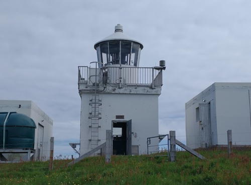
1984. Active; focal plane 114 m (374 ft); three white flashes, separated by 3.1 s, every 20 s. 13 m (42 ft) lantern atop a square equipment building, painted white. Two other small buildings are nearby. Barry Gannon's 2020 photo is at right, Charles Tait has a good photo and a second photo, Trabas has Kees Aalbersberg's photo, Roddy MacDonald has a very distant view, and Google has a satellite view. Rona is an uninhabited island roughly 70 km (45 mi) north northeast of the Butt of Lewis; it is often called North Rona to distinguish it from another Rona (which also has a lighthouse) in the Inner Hebrides (see the Highlands page). Located atop a hill at the northeastern end of the island. Accessible only by helicopter or by boat in difficult seas (boats can be chartered from Lewis). Site open, tower closed. Operator: Northern Lighthouse Board. Site manager: Rona and Sula Sgeir National Nature Reserve. ARLHS SCO-153; Admiralty A3869; NGA 3574.
Sula Sgeir
Date unknown. Active; focal plane 74 m (243 ft); white flash every 15 s. 5 m (17 ft) square 1-story metal structure, painted white. Jamie McMillan has a 2013 photo, John MacFarlane has a photo, Trabas has Kees Aalbersberg's very distant view, and Google has a satellite view. Sula Sgeir is a small, rocky island about 65 km (40 mi) north of the Butt of Lewis and 20 km (12.5 mi) west southwest of Rona. The island is known for its seabird breeding colonies, especially the gannets (sula) for which it is named. Located atop a steep bluff at the southwestern end of the island. Accessible only by boat in difficult seas (boats can be chartered from Lewis). Site and tower closed. Site manager: Rona and Sula Sgeir National Nature Reserve. ARLHS SCO-230; Admiralty A3870; NGA 3572.
 

Rona Light, July 2020
Google Maps photo by Barry Gannon
 

Lewis (Leòdhas) Lighthouses
The Isle of Lewis and Isle of Harris are regions of a single island, Lewis being the larger and northern section. More than half the population of the Western Isles lives in Lewis.
[Aird Laimishader (Loch Carloway) (2?)]
Date unknown (station established 1892). Active; focal plane 63 m (207 ft); white flash every 6 s. 5 m (17 ft) square skeletal tower, the upper portion enclosed with white panels. Tormod MacArtair has a closeup photo, Spencer has a page with several photos, and Google has a satellite view. Located on a headland on the north side of the entrance to Loch Carloway, on the west coast of Lewis. Site status unknown. ARLHS SCO-040; Admiralty A4032; NGA 3916.
* Butt Of Lewis (Rubha Robhanais)
1862 (David and Thomas Stevenson). Active; focal plane 52 m (170 ft); white flash every 5 s. 37 m (120 ft) brick tower with lantern and gallery. The lighthouse is unpainted red brick (unusual for Scotland) with buff trim; the lantern is painted black. 2-story keeper's house and other light station buildings. The tower also carries antennas for the Differential Global Positioning Service (DGPS). A photo is at the top of this page, Trabas has a closeup by Ian Wright, a 2022 photo is available, David Purchase has a 2010 photo, Wikimedia has many photos, Lighthouse Accommodations has a page for the lighthouse, Marinas.com has aerial photos, Huelse has a historic postcard view, and Google has a street view and a satellite view. In 1998 this was one of the last Scottish lighthouses to be automated. The 150th anniversary of the light was celebrated on 15 October 2012. Located at the northernmost tip of the island, about 5 km (3 mi) northwest of Port Ness; this is reputed to be the windiest place in the United Kingdom. Accessible by road; parking provided. Site open, tower closed. Operator: Northern Lighthouse Board. . ARLHS SCO-027; Admiralty A3968; NGA 3820.
* Tiumpan Head (Rubha Tiompan)
1900 (David A. and Charles Stevenson). Active; focal plane 55 m (180 ft); two white flashes every 15 s. 21 m (69 ft) masonry tower with lantern and gallery attached to 1- and 2-story keeper's houses. Lighthouse painted white with buff trim; lantern painted black. The keeper's houses are now occupied by a kennel and cattery. Lorna Campbell's photo appears at right, Gordon Wilson has a good photo, Wikimedia has several photos, Trabas has a photo, Lighthouse Accommodations has a page for the lighthouse, Marinas.com has aerial photos, Huelse has a historic postcard view, and Google has a street view and a satellite view. "Tiumpan" is pronounced "Chumpin." Located at the end of the Eye Peninsula (known locally as Point) about 14 km (9 mi) northeast of Stornoway. Accessible by road; limited parking available. Site open, tower closed. Operator: Northern Lighthouse Board. Site manager: Tiumpan Head Kennels & Cattery. . ARLHS SCO-242; Admiralty A3972; NGA 3824.

Tiumpan Head Light, Aird, July 2018
Wikimedia Creative Commons photo by Lorna M. Campbell
* Arnish Point
1853 (Alan Stevenson). Active; focal plane 17 m (56 ft); flash every 10 s, white or red depending on direction. 14 m (46 ft) cylindrical masonry tower, painted white; lantern painted black. 1-story keeper's house (private residence). Jim Brodie's photo is at the top of this page, Trabas has an excellent closeup by Ian Wright, Phil Smith has a closeup, Sean Adams has a 2021 closeup, Marinas.com has aerial photos, Huelse has a historic postcard view, and Google has a satellite view. Located on a headland on the west side of the entrance to Stornoway Harbour, about 5 km (3 mi) south of town. The area is accessible by road but a short walk is needed to reach the lighthouse. Site open, tower closed. Operator: Northern Lighthouse Board. . ARLHS SCO-010; Admiralty A3976; NGA 3828.
[Milaid Point (Gob na Milaid) (2)]
Date unknown (station established 1912). Active; focal plane 17 m (56 ft); white flash every 15 s. 7 m (24 ft) square skeletal tower, the upper portion enclosed with white panels. John Maclennan has a closeup photo and Google has a fuzzy satellite view. Located on a headland on the east coast of Lewis, about 6 km (3.5 mi) east of Leumrabhagh. Accessible only by boat. Site status unknown. Operator: Northern Lighthouse Board. ARLHS SCO-136; Admiralty A3984; NGA 3860.
Rubh Uisenis (3)
Date unknown (station established 1857). Active; focal plane 24 m (79 ft); white flash every 5 s. 7 m (23 ft) round cylindrical tower with lantern and gallery, painted white. A 6th order Fresnel lens from this lighthouse is displayed at the Museum of Scottish Lighthouses in Fraserburgh. UKLighthouseTour.com has a closeup photo (1/3 the way down the page) and Google has a satellite view. John Maclennan has a 1990 photo of the second (1885) lighthouse. The light guides ships through the strait between the Shiant Islands and the southeastern coast of the Isle of Lewis. According to Spencer this is "perhaps the most remote of land-based lighthouses in Britain." Located on a headland about 15 km (9 mi) northeast of Scalpay. Accessible only by boat. Site status unknown. Operator: Northern Lighthouse Board. ARLHS SCO-192; Admiralty A3986; NGA 3864.

Harris (Hearadh) and Scalpay (Sgalpaigh) Lighthouses
* Eilean Glas (1)
1789 (Thomas Smith). Inactive since 1824. 6.5 m (21 ft) round stone tower, painted white, attached to a keeper's house complex. Lantern removed. Darlene Chisholm's photo is at right. This tower is attached to the same station complex as its successor (next entry). Site open, tower closed.

1789 Eilean Glas Light, Scalpay, January 2016
photo copyright Darlene Chisholm; used by permission
Eilean Glas (2)
1824 (Robert Stevenson). Station established 1789. Active; focal plane 43 m (141 ft); three white flashes, separated by 2 s, every 20 s. 30 m (98 ft) masonry tower with lantern and gallery attached to a 1-story keeper's house. The 2nd order Fresnel lens (1907) is on display at the Science Museum in South Kensington, London. Lighthouse painted with horizontal red and white bands; lantern painted black. This is Scotland's fourth oldest light station and the oldest on the west coast. Simon Stewart's photo is at right, Trabas has an excellent closeup photo, Spencer has two photos, Charles Tait also has photos, Lighthouse Accommodations has a page for the lighthouse, Marinas.com has aerial photos, Huelse has a historic postcard view, and Google has a satellite view. A postcard view of the original lighthouse and an account of its history are available. The light station was sold in 1984 to Brenda and Robert Ford-Sagers. In 1996 Ms. Ford-Sagers created a trust called Friends of Eilean Glas and sold the lighthouse to the trust for £50,000. Unfortunately the trust was not properly set up, leading to a lengthy court case concerning the status of the property. In 2006, however, an appeals court reversed lower court rulings and confirmed the trust's ownership. In 2019 NLB announced plans for restoration of the tower. Located on a small island (accessible at low tide) at the eastern end of Scalpay, a island in the mouth of East Loch Tarbert. Accessible by a hike of about 3 km (2 mi) roundtrip from the end of the road southeast of Scalpay village. Site open, tower closed. Operator: Northern Lighthouse Board. . ARLHS SCO-069; Admiralty A3990; NGA 3868.
Sgeir Ghlas (Gray Reef, Tarbert)
Date unknown. Active; focal plane 9 m (29 ft); white, red, or green light depending on direction, 2 s on, 2 s off. 5.5 m (18 ft) cylindrical concrete tower with lantern and gallery, painted white. Trabas has a photo by Ian Wright, Richard Webb has a 2009 photo, Spencer has a good photo, Colin Kinnear also has a photo, Mirosław Dąbrowski has a 2022 drone view, and Google has a satellite view. Located on a small island in East Loch Tarbert about 5 km (3 mi) southeast of Tarbert. Accessible only by boat; good views from ferries between Tarbert and Uig on the Isle of Skye. Site open, tower closed. Operator: Northern Lighthouse Board. ARLHS SCO-207; Admiralty A3993; NGA 3876.
Eilean Glas Light
Eilean Glas Light, Scalpay, June 2005
Geograph Creative Commons photo by Simon Stewart
* Leverburgh (Laimhrig Mhor, Hebrides Beacon)
Date unknown. Inactive. 9 m (30 ft) octagonal concrete tower with lantern, painted white. Spencer has a page with excellent photos, Ian Wright has a distant view, and Google has a street view and a satellite view. Information is needed on the history of this lighthouse, which was replaced by a mast light on the ferry pier. The Leverburgh Range is now marked by front and rear lights on masts, but the historic tower continues to be charted as an unlighted rear beacon of the range. Located on the west side of the harbor entrance in Leverburgh, on Harris Sound at the southern end of the Isle of Harris. Site open, tower closed. Owner/site manager: unknown. ARLHS SCO-346; ex-Admiralty A3994.5.
Dubh Sgeir
Date unknown. Active; focal plane 9 m (30 ft); two quick white flashes every 5 s. 6 m (20 ft) octagonal cylindrical concrete tower painted with black and red horizontal bands. Spencer has a photo, Trabas has Kees Aalbersberg's photo, and Bing has a satellite view. Located on a skerry about 1.2 km (3/4 mi) southwest of Leverburgh. Owner/site manager: unknown. Admiralty A3994.2.

Flannan Isles (Na h-Eileanan Flannach) Lighthouse
Flannan Islands (Eilean Mor)
1899 (David A. Stevenson). Active; focal plane 101 m (330 ft); two white flashes, separated by 5.5 s, every 30 s. 23 m (75 ft) masonry tower with lantern and gallery attached to a 1-story keeper's house. 3rd order clamshell Fresnel lens. Lighthouse painted white with buff trim; lantern painted black. Chris Downer's photo is at right, James Macaulay has a 2021 photo, Peter Standing has a 2008 photo, Charles Tait has excellent photos, a 1993 photo is available, Lighthouse Accommodations has a page for the lighthouse, Huelse has a historic postcard view, and Bing has a satellite view. This light station was the scene of a mysterious disaster in December 1900, when all three keepers disappeared; the 2017 movie Keepers and the 1980 opera The Lighthouse, by Peter Maxwell Davies, are both based on this incident. Lighthouse Digest has T.M. Jacobs's July 2005 article on the disappearance. The Flannan Isles are a group of small uninhabited islands in the Atlantic about 35 km (22 mi) west of the Isle of Lewis; the Gaelic name means "the Seven Hunters." In December 2017 a memorial to the vanished keepers was unveiled at the shore near the village quay in Breasclete. In 2018 the community group Urras an Taighe Mhòir announced plans to buy the station's onshore keeper's house in Breasclete (seen in a photo by Ian Cowe and a street view and satellite view by Google); the group received a grant of £18,000 to pay for a feasibility and technical study of its plans. Ownership of the house was transferred to the group in October 2019. In 2023 it was announced that part of the house would be opened as a museum and the rest would be available for vacation rental. Located atop the largest of the islands. Accessible only by boat. Site and tower closed. Operator: Northern Lighthouse Board. ARLHS SCO-084; Admiralty A4028; NGA 3912.

Flannan Islands Light, August 2012
Geograph Creative Commons photo by Chris Downer

North Uist Lighthouses
The islands of North Uist and South Uist are joined by causeways. The islands are thinly populated, having a total population of about 3000.

Haskeir
1997. Active; focal plane 44 m (144 ft); white flash every 20 s. 9 m (30 ft) round cylindrical white fiberglass tower with lantern and gallery. A 2010 photo and a closeup are available, UKLighthouseTour.com has a page describing a 2018 visit to the lighthouse, George Brown has a 2005 view, Trabas has Kees Aalbersberg's very distant view, and Bing has a satellite view. Located on a rocky islet about 13 km (8 mi) west of the northwestern point of North Uist. Accessible only by boat. Site open, tower closed. Operator: Northern Lighthouse Board. ARLHS SCO-324; Admiralty A4020.3; NGA 3954.
[Rubha an Fhigheadair (Weaver's Point)]
Date unknown (station established 1912). Active; focal plane 24 m (79 ft); white flash every 3 s. 5 m (17 ft) square skeletal tower enclosed with white panels. Spencer has several photos and Trabas has Kees Aalbersberg's photo, but the small light is barely visible in Google's distant satellite view. Located on a headland on the east coast of North Uist marking the entrance to Lochmaddy. Accessible only by boat. Site status unknown. Operator: Northern Lighthouse Board. ARLHS SCO-254; Admiralty A3996; NGA 3888.
Monach Isles (Shillay, Siolaigh)
1864 (David and Thomas Stevenson). Reactivated (inactive 1942-2008); focal plane 47 m (154 ft); two white flashes every 15 s. 41 m (133 ft) unpainted brick tower with lantern and gallery attached to 2-story keeper's house. The Fresnel lens was removed in 1997 and is on display at the Museum of Scottish Lighthouses in Fraserburgh. The original clockwork mechanism was removed in 2008 to be displayed with the lens after restoration. Howard Steen has a photo, Barry Gannon has a closeup, Charles Tait has several photos of the light station, Jac Volbeda has a view from the sea, Bob Jones has a distant photo, Trabas has Kees Aalbersberg's view from the sea, Wikimedia has several distant views, Lighthouse Accommodations has a page for the lighthouse, and Google has a satellite view. There was no light on the island from 1942 until 1997, when an active light was established on a 5.5 m (18 ft) skeletal tower on the southeast coast of the island about 250 m (800 ft) from the historic station. In July 2008 NLB announced that to increase the range of the light it was being moved back into the historic lighthouse. The lighthouse was reactivated on 25 July 2008. The Monach Isles (Eilean Heisgeir) are small islands, unhabited since 1942, about 11 km (7 mi) southwest of the western point of North Uist. Located on Shillay (Siolaigh), a small island at the western end of the group. Accessible only by boat. Site and tower closed. Operator: Northern Lighthouse Board. ARLHS SCO-137; Admiralty A4020.5; NGA 3955.

South Uist Lighthouse
Ushenish
1857 (David and Thomas Stevenson). Active; focal plane 54 m (176 ft); flash every 20 s, white or red depending on direction. 12 m (39 ft) cylindrical masonry tower with lantern and gallery. Tower painted white, watch room buff, lantern black. 1-story keeper's houses and other buildings enclosed by a stone wall. A photo is at right, Mark Downie has a 2022 photo, Trabas has an aerial view by Kees Aalbersberg, Charles Tait has a photo showing the isolated situation of this station, Neil King has an aerial photo, Trabas has Kees Aalbersberg's distant view, Lighthouse Accommodations has a page for the lighthouse, and Google has a satellite view of the station. Located on the easternmost point of South Uist, about 7 km (4.5 mi) southeast of Loch Sgioport. Accessible only by boat; an unpaved road leads to the light station from a sheltered landing point. Site and tower closed. Operator: Northern Lighthouse Board. . ARLHS SCO-249; Admiralty A4004; NGA 3900.
Ushenish Light
Ushenish Light, South Uist, February 2008
Flickr photo copyright billynxn; used by permission

Barra Lighthouse
Barra Head (Berneray)
1833 (Robert Stevenson). Active; focal plane 208 m (683 ft); white flash every 15 s. 18 m (60 ft) masonry tower with lantern and gallery, attached to a 1-story keeper's house. Lighthouse painted white, lantern black. This historic lighthouse marks the entrance from the Atlantic to the Sea of the Hebrides. Rene Schoeters has a 2017 closeup photoBob Jones has a good photo, Charles Tait has excellent photos, Lighthouse Accommodations has a page for the lighthouse, and Google has a satellite view. In 2019 NLB announced plans to renovate the living quarters of the station so that maintenance crews can work there safely. The light station is located atop spectacular vertical cliffs on the narrow western spine of Berneray, southernmost of the Western Isles. Accessible only by boat. Site open, tower closed. Operator: Northern Lighthouse Board. ARLHS SCO-016; Admiralty A4020; NGA 3952.

St. Kilda Lightbeacons
St. Kilda is a group of four small islands about 64 km (40 mi) west northwest of North Uist. The islands have been uninhabited since 1930 but since 1957 Britain has maintained a small military station on Hirta, the largest island, with rotating crews of several dozen personnel.

[St. Kilda Range Rear]
Date unknown. Active; focal plane 38 m (125 ft); white light, 4 s on, 1 s off. Light mounted atop a 2 m (7 ft) square concrete cairn. Trabas has Kees Aalbersberg's photo and Bing has a satellite view. The range guides ships into a partly-sheltered bay on the southeast side of Hirta. The front light is on a short post 100 m (110 yd) downhill. Site open, tower closed. Admiralty A4047.1; NGA 3959.

Information available on lost lighthouses:

  •  

Notable faux lighthouses:

  •  

Barra Head Light, Barra, March 2017
Google Maps photo by Rene Schoeters

Adjoining pages: East: Highland Council Area | South: Argyll and Bute

Return to the Lighthouse Directory index | Ratings key

Posted October 2004. Checked and revised July 15, 2023. Lighthouses: 17. Site copyright 2023 Russ Rowlett and the University of North Carolina at Chapel Hill.