Lighthouses of the United States: Iowa

The United States of America is a federal union of 50 states and a capital district. The state of Iowa is in the center of the country on the west bank of the Mississippi River, north of Missouri and south of Minnesota. Iowa was established as a territory in 1838 and admitted to the Union as the 29th state in 1846.

Navigable waterways in Iowa include the Mississippi River on the east and the Missouri River on the state's southwestern border. The U.S. Coast Guard Sector Upper Mississippi River, based in St. Louis, Missouri, is responsible for navigation aids on the rivers, but very few of them meet the Directory's definition of a lighthouse. All the lighthouses listed here are privately maintained.

The town of Storm Lake in northwestern Iowa has become a center of lighthouse interest in the state with several working lighthouses and a number of faux lighthouses.

To be listed in the Directory a lighthouse must actually serve as an aid to navigation. This means it must be located on a navigable lake or river and must be lit as a navigational aid at least during the local boating season.

ARLHS numbers are from the ARLHS World List of Lights. USCG numbers are from volume 5 of the U.S. Coast Guard List of Lights.

General Sources
U.S. Coast Guard Navigation Center: Light Lists
The USCG Light List can be downloaded in pdf format.
Navionics Charts
Navigation chart for Iowa.

Siebens Memorial Light, Storm Lake
Storm Lake United photo from VisitStormLake.com
Mississippi River Lighthouses
* Fort Madison Harbor (?)
Date unknown. Removed, perhaps temporarily, as of 2022. This was a 4.5 m (15 ft) round concrete tower with lantern, painted with black and white spiral bands. No photo available but Google has a street view and a satellite view. The lighthouse was removed during a reconstruction of the marina; we don't know if it will be replaced. Construction was continuoing in 2023. Located on the west side of the entrance to the marina at Fort Madison, river mile 383.7. Site open, tower closed. Owner/site manager: City of Fort Madison (Riverview Marina. ex-USCG 5-15407.
* Peevler (Keokuk Yacht Club)
2001. Active (unofficial but charted by Navionics; maintained by the club); focal plane 23 ft (7 m); continuous green light. 20 ft (6 m) round tower with a small lantern. Lighthouse painted white, lantern red. A 2007 photo and another photo (1/3 the way down the page) are available, Google has a street view, and the lighthouse can be seen in Google's satellite view. The lighthouse was built as a memorial to Bill Peevler, who had been the commodore of the club. Located at the end of the pier of the Keokuk Yacht Club, on the north side of Keokuk at river mile 366. Site open, tower closed. Owner/site manager: Keokuk Yacht Club.

Rathbun Lake Lighthouse
* Rathbun Lake Marina
2019. Active (not charted by Navionics); focal plane unknown; continuous (?) white light. 52 ft (16 m) round precast concrete tower with lantern and gallery, painted with red and white horizontal bands. Mike Eaton has a closeup photo and Google has a satellite view. Rathbun Lake is a flood control reservoir on the Chariton River near Moravia in Appanoose County, about 75 mi (120 km) southeast of Des Moines. The lake is about 15 mi (25 km) long. Located on a hilltop overlooking the marina. Site open, tower closed. Owner/site manager: Rathbun Lake Marina.

Lake Panorama Lighthouse
Lake Panorama is a large planned community near Panora in Guthrie County about 45 miles (72 km) west of Des Moines. The lake is about 7 mi (11.7 km) long and was formed by damming the Middle Raccoon River, a tributary of the Des Moines River.
* Lake Panorama
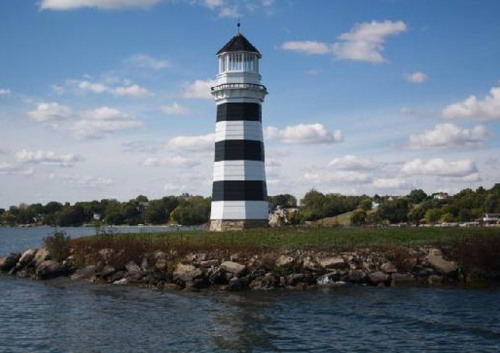
1976. Active (not charted by Navionics); focal plane about 7 m (23 ft); light pattern unknown. 6 m (20 ft) round tower with lantern, painted with black and white horizontal bands. A photo is at right, another photo is available, Daniel Suhr has a photo of the light in action, and Google has a satellite view. The lighthouse was built by a resident, Max Antrim. Note: a photo is available of a second lighthouse on the lake; we need information about this tower. Located on the marina jetty on the east side of the lake. Site open, tower closed. Owner/site manager: Coulter's Panorama Marine.

Missouri River Lighthouses
* Hildrith Lighthouse Marina
1960. Active (unofficial; charted by Navionics as a landmark); focal plane about 25 ft (7.5 m); flashing white light. 18 ft (5.5 m) hexagonal tower with a small lantern, painted white with narrow horizontal bands of blue, black, and red. Marvin Hildrith has a 2017 photo, and Google has a satellite view. Located on an Indian mound on the east side of the Missouri at river mile 699.5 and the end of 170th Street, southwest of Whiting in Monona County. Site and tower open. Owner/site manager: Hildrith Lighthouse Campground.
* Sioux City Marina
Date unknown. Active (official but not charted by Navionics; privately maintained); focal plane about 8 m (26 ft); continuous white light. This light appears to be in the cupola atop an octagonal gazebo. Rich Rensberger has a view across the harbor and Google has a satellite view. This light marks the head of navigation on the Missouri River. Located on the west side of the entrance to the Sioux City Marina. Site open, tower closed. USCG 5-17685.

Lake Panorama Light, Guthrie County
tripadvisor.com photo "provided by management"

Storm Lake Lighthouses
Storm Lake is a university town in Buena Vista County in northwestern Iowa. The town is built along the north shore of the lake for which it is named; the lake itself is roughly elliptical and measures about 3.2 mi by 1.6 mi (5.3 by 2.7 km).
* Storm Lake (Awaysis Park)
2008. Active (not charted by Navionics); focal plane 59 ft (18 m); continuous white light. 60 ft (18 m) octagonal steel tower, the lowest story with a sandstone veneer, with lantern and a large observation deck. A external stairway spirals around the tower to the observation deck; there is also an elevator inside the tower. Ed Tullar's photo is at right, Amy Rodriguez has a 2011 closeup, and Google has a street view and a satellite view. The lighthouse closed in 2022 for renovations, reopening in July 2023. Located in Awaysis Park, a city park on on Lakeshore Drive at the northeastern corner of the lake. Site and tower open. Owner/site manager: City of Storm Lake.
* Siebens Memorial
1992. Active (not charted by Navionics); focal plane about 36 ft (11 m); flashing white light. 30 ft (9 m) brick tower with lantern; rotating aerobeacon. A photo is at the top of this page, another closeup is available, Lighthouse Digest has a photo and the text from the plaque on the lighthouse, and Google has a satellite view. This lighthouse was built on the campus of Buena Vista University in memory of BVU trustee and benefactor Harold Walter Siebens. Located near the Siebens Field House on the north shore of Storm Lake. Site open, tower closed. Owner/site manager: Buena Vista University.
Stoney Point
1993. Active (not charted by Navionics); focal plane 38 ft (11.5 m); white flash every 15 s. 26 ft (8 m) octagonal stucco-covered wood tower with lantern. Tower painted a light beige color, lantern painted black. No photo available but Google has a satellite view. The light was built privately by Kirby Roberts, a retired businessman. Located on a prominent point of land on the southwestern side of Storm Lake. Site and tower closed (private), but the light is easily seen from the lake. Owner/site manager: private.

Awaysis Park Light, Storm Lake, June 2017
Google Maps photo by Ed Tullar

West Okoboji Lake Lighthouses
West Okoboji Lake is one of the interconnected Iowa Great Lakes at Spirit Lake in Dickinson County, close to the Minnesota border in northwestern Iowa. The lake is about 6 mi (10 km) long and averages about one mile (1.6 km) in width.

* West Lake Okoboji Harbor Starboard
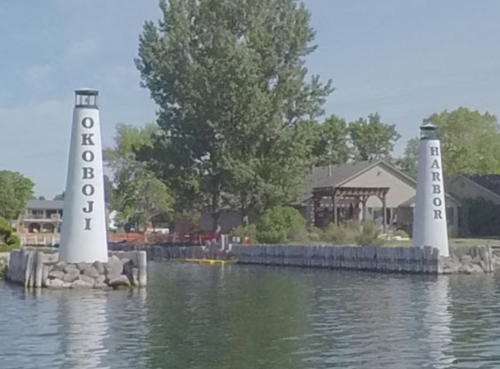
1968. Active (not charted by Navionics); focal plane 28 ft (8.5 m); flashing red light. 25 ft (7.5 m) round stucco-covered steel tower, painted white. This light is on the right in the lake view at right, Brodie Thies has a good photo, a small photo of both lights is available (3/4 the way down the page), and Google has a satellite view. Located on a short jetty on the north side of the entrance to a large residential neighborhood at the northwestern corner of the lake. Site open, tower closed. Owner/site manager: West Okoboji Harbor Homeowners Association. ARLHS USA-919.
* West Lake Okoboji Harbor Port
1968. Active (not charted by Navionics); focal plane 28 ft (8.5 m); flashing green light. 25 ft (7.5 m) round stucco-covered steel tower, painted white. This light is on the left in the lake view at right and on the right in Brodie Thies's photo of both lighthouses, a small photo of both lights is available (3/4 the way down the page), and Google has a satellite view. Located on a short jetty on the south side of the entrance to a large residential neighborhood at the northwestern corner of the lake. Site open, tower closed. Owner/site manager: West Okoboji Harbor Homeowners Association. ARLHS USA-918.

Clear Lake Lighthouse
Clear Lake is a natural (spring-fed) lake in Cerro Gordo County, west of Mason City in northern Iowa. The lake is very popular as a fishing and summer vacation destination.

Clear Lake (IRBC)
Date unknown. Active (?) (not charted by Navionics); light pattern unknown. Approx. 65 ft (20 m) octagonal cylindrical tower with lantern and gallery. Shad & Melissa Walker have a 2019 photo, another photo is available, and Google has a satellite view. The lighthouse is built on the grounds of a religious summer camp. Located at Ventura near the west end of the lake. Site open to campers, tower status unknown. Owner/site manager: Iowa Regular Baptist Camp.
 

Harbor Lights, West Lake Okoboji, August 2021
Google Maps lake view by University of Northern Iowa GeoTREE Center
 

Notable faux lighthouses:

Adjoining pages: North: Minnesota | East: Illinois | South: Missouri | West: Nebraska

Return to the Lighthouse Directory index | Ratings key

Posted July 15, 2003. Checked and revised October 1, 2023. Lighthouses: 12. Site copyright 2023 Russ Rowlett and the University of North Carolina at Chapel Hill.