Lighthouses of Indonesia: Bali

The Republic of Indonesia has been independent since 1945, after having been the Dutch East Indies for more than 350 years. It is a huge country, stretching along both sides of the Equator for more than 46 degrees of longitude (roughly 5100 km or 3200 miles). Comprised of some 17,000 islands (more than 6000 inhabited islands), it has hundreds of major aids to navigation.

The island arc that begins in the west with the major islands of Sumatra and Java continues eastward through a chain of smaller islands known in English as the Lesser Sunda Islands and in Indonesian as the Nusa Tenggara ("Southeastern Islands"). From west to east the major Lesser Sunda Islands are Bali, Lombok, Sumbawa, Sumba, Flores, and Timor.

Indonesia is divided into 38 provinces (provinsi) and the provinces are subdivided into county units called regencies (kabupaten). This page includes lighthouses of Bali Province. Bali is a roughly triangular island with the apex of the triangle pointed south. At its northwestern corner the island is barely separated from Java by the Bali Strait. On the east the Lombok Strait separates Bali from Lombok. The Bukit Peninsula, at the southern apex of Bali, is connected to the rest of the island by a very narrow isthmus. Bali's best known tourist facilities are on the Bukit Peninsula.

More than 700 languages are spoken in Indonesia. The official national language, Indonesian (Bahasa Indonesia), was standardized from a form of Malay that served as a lingua franca across the archipelago. In Indonesian a lighthouse is a mercusuar or a menara suar. Tanjung is a cape, ujung is a headland or point of land, bukit is a hill, sungai is a river, kuala or muara is an estuary or river mouth, pulau is an island, karang is a reef, batu is a rock, laut is a sea, selat is a strait, teluk is a bay, pelabuhan is a harbor, and labuhan is a port. It's also worth knowing that the word for an island is nusa in Balinese and gili in the Sasak language spoken on neighboring Lombok.

Aids to navigation in Indonesia are operated and maintained by the Directorate of Marine Navigation within the Directorate General of Sea Transportation.

ARLHS numbers are from the ARLHS World List of Lights. DSI numbers are Indonesian light list numbers as listed by the Benoa Navigation District. Admiralty numbers are from volume Q of the Admiralty List of Lights & Fog Signals. U.S. NGA List numbers are from Publication 112.

General Sources
Sarana Bantu Navigasi-Pelayaran
From the Benoa Navigation District, photos and data on navigational aids. The district includes Bali, Lombok, and Sumbawa.
Leuchttürme in Indonesien
Photos posted by Andreas Köhler.
Online List of Lights - Indonesia
Photos by various photographers posted by Alexander Trabas. Photos for Bali were contributed by Köhler, Jim Smith, and Rainer Arndt.
World of Lighthouses - Indonesia
Photos by various photographers available from Lightphotos.net.
Navionics Charts
Navigation chart for Bali.

Pandawa Light, Bukit Peninsula, June 2021
ex-Google Maps street view by Da Renwei
Denpasar City Lighthouse
Denpasar, at the southeastern corner of Bali, is the capital of the province. Rapidly growing, it had a population approaching 900,000 in 2017.

Sanur Beach North
Date unknown. Active; focal plane about 12 m (39 ft); green light, pattern unknown. Approx. 12 m (39 ft) green tower on a platform supported by piles. Jenzy Ben has a sea view of the two Sanur Beach Lights and Google has a satellite view. The two lights mark a break in the reef off Sanur Beach in Denpasar. Accessible only by boat. Site open, tower closed. Charted by Navionics but not listed by the Admiralty.
Sanur Beach South
Date unknown. Active; focal plane about 12 m (39 ft); red light, pattern unknown. Approx. 12 m (39 ft) red tower on a platform supported by piles. Jenzy Ben has a sea view of the two Sanur Beach Lights and Google has a satellite view. The two lights mark a break in the reef off Sanur Beach in Denpasar. Accessible only by boat. Site open, tower closed. Charted by Navionics but not listed by the Admiralty.
Tanjung Serangan (2)
2006 (station established 1992). Active; focal plane 17 m (56 ft); white flash every 5 s. 17 m (56 ft) square white skeletal tower mounted on a square platform supported by piles. A distant street view is available and Google has a satellite view. Located on a reef off Sanur Beach on the south side of Denpasar, about 5 km (3 mi) northeast of Benoa Harbor. Accessible only by boat. Site open, tower closed. DSI-4169; Admiralty Q1290; NGA 25528.

Badung Regency (Bukit Peninsula) Lighthouses
The Bukit Peninsula, at the southern tip of Bali, is the location of many of the island's upscale tourist facilities. The peninsula is connected to the rest of Bali by a narrow isthmus.

*
Benoa Harbor (2)
2017 (station established 1979). Active; focal plane 33 m (108 ft); white flash every 5 s. 30 m (98 ft) 12-sided tower with lantern and gallery. Entire lighthouse is white. Clarence Yeo's photo is at right, Cahyana Wiyana has a closeup photo, Bali Yacht Services has a January 2018 photo, and Google has a satellite view and a 2021 street view. Benoa is a port and popular tourist destination at the northeast corner of the Bukit peninsula near the southern tip of Bali. This lighthouse replaced a 25 m (82 ft) square skeletal tower with lantern and gallery. Köhler has a 2011 photo of the earlier lighthouse, Trabas also has Köhler's photo, Riza Nugraha has a photo, and Google has a 2015 sea view and a 2016 street view. Located on the main quay at Benoa Harbor, near the ferry terminal. Site presumably open, tower status unknown. ARLHS IDO-110; DSI-4090; Admiralty Q1291; NGA 25524.

Benoa Harbor Light, Benoa, March 2023
Google Maps photo by 無名
* Benoa Range Rear (2)
2011 (station established 1983). Active; focal plane 14 m (46 ft); white light, 3 s on, 3 s off. 12 m (39 ft) square white concrete skeletal tower. Google has a drone view, a street view, a sea view, and a satellite view. This is an approach range for Benoa harbor. The front light is on a post on a platform about 550 m (1/3 mi) offshore. Located just off the beach near the Tanjung Benoa Beach Resort. Site open, tower closed. DSI-4092; Admiralty Q1291.21; NGA 25526.1.
* Pandawa (Pantai Pandawa)
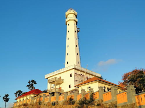
2017. Active; focal plane 24 m (79 ft); white flash every 2 s. 20 m (66 ft) 3-stage octagonal concrete tower centered on an octagonal 1-story building. A photo is at the top of this page, Wahyu Radhitya has a January 2018 photo, Fauzan Azhmy has an aerial view, Eko Sulistiyono has a street view, and Google has a satellite view. Located at Pandawa Beach at the southern end of the Bukit Peninsula. Site open, tower status unknown. DSI-4171; Admiralty Q1291.37.
Bukit Badung (2)
2013. Active; focal plane 220 m (722 ft); three white flashes every 20 s. Approx. 40 m (131 ft) square skeletal tower, painted white. A 2023 photo of the light in action is available and Google has a 2014 street view and a satellite view. A closeup photo of the previous (1985) lighthouse is available (2/3 the way down the page) and ARLHS also has that photo. This is a landfall light for Bali; its listed range is 46 km (29 mi). The area is popular for paragliding. Located atop a very steep bluff above the Green Bowl Beach at the southern end of the Bukit Peninsula. Accessible by road. Site and tower closed. ARLHS IDO-118; DSI-4176; Admiralty Q1291.4; NGA 25520.
* Tanjung Mebulu (Uluwatu) (2)
2015 (station established 1992). Active; focal plane 80 m (262 ft); white flash every 5 s. Approx. 24 m (79 ft) 2-stage tower; a square cylindrical concrete skeletal tower atop an octagonal castellated tower. Entire lighthouse is white. A photo is at right, Rizki Kurniawan has a photo, Guz Aryan has a closeup photo, and Google has a satellite view. This rather ornate lighthouse replaced an ordinary square skeletal tower; Köhler has a 2011 distant view, Trabas has Köhler's photo, and Bing has a satellite view. Located atop Bukit Jaran, a cliff at the western end of the Bukit Peninsula. Site open, tower closed. DSI-4177; Admiralty Q1291.6; NGA 25522.
* Kelan
2013. Active; focal plane 33 m (105 ft); white flash every 5 s. 30 m (98 ft) square skeletal tower with gallery, painted white. Anugrah Syahryan Nuzula has a beach view and Google has a satellite view and a closeup street view. Located on the beach at the foot of the Kelan pier, on the west side of the Bukit Isthmus just south of the international airport. Site open, tower closed. DSI-4155; Admiralty Q1291.3; NGA 25521.

Tanjung Mebulu Light, June 2022
Google Maps photo by Александр «wow park» Гриц

Jembrana Regency (Bali Strait) Lighthouses
Broad in the south, the Bali Strait narrows to 2400 meters in the north. A bridge connecting Java to Bali is feasible and has been considered, but cost and local objections have suspended the project.
Tanjung Pengambengan
1971. Active; focal plane 43 m (141 ft); white flash every 5 s. 33 m (108 ft) square tapered pyramidal iron skeletal tower with lantern and gallery, painted white. Nyoman Sutapa has a 2022 closeup photo and Google has a closeup street view (a similar view is at right) and a satellite view. Located on a promontory facing the Bali Strait at Pengambengan on the southwest coast of the island, about 5 km (3 mi) southwest of Negara. Site status unknown. ARLHS IDO-045; DSI-4080; Admiralty Q1282; NGA 23804.
Gilimanuk Cable Beacon
Date unknown. Active; focal plane about 14 m (46 ft); yellow light, pattern unknown. Approx. 10 m (33 ft) yellow barbell-shaped fiberglass tower. Google has a street view and a satellite view. Located just off the south end of the Gilimanuk waterfront. Accessible only by boat but easily seen from shore. Site open, tower closed. Admiralty Q1253.
* Gilimanuk (Gilimanuk South) (2)
1999. Active; focal plane 24 m (79 ft); flashing white light, pattern unknown. 20 m (66 ft) square skeletal tower with gallery, painted white. Google has a street view and a satellite view. Gilimanuk, on the Bali Strait, is the terminal for ferries to and from Ketabang, East Java, on the other side of the strait. As the principal link between the islands this is a very heavily traveled ferry route; ferries depart at frequent intervals 24 hours a day. Located at the south end of the ferry terminal in Gilimanuk. Site open, tower closed. DSI-4076; Admiralty Q1258.13.
[Gilimanuk Entrance]
Date unknown. Active; focal plane 15 m (49 ft); red flash every 4 s. 15 m (49 ft) red post mounted on a triangular platform supported by three piles. M. Marganti has a sea view and Google has a distant satellite view. Located at the start of the entrance channel for Gilimanuk, about 800 m (1/2 mi) north of the ferry terminal. Accessible only by boat but ferry passengers have an excellent view. Site open, tower closed. DSI-4033; Admiralty Q1257.5; NGA 23791.

Tanjung Pengambengan Light, Pengambengan, April 2015
Google Maps street view

Buleleng Regency (North Coast) Lighthouses
[Tanjung Batulicin]
Date unknown. Active; focal plane about 15 m (49 ft); white flash every 5 s. 15 m (49 ft) white post mounted on a triangular platform supported by piles. Google has a satellite view. Located off a promontory on the east side of the south entrance to the narrowest passage of the Bali Strait. Accessible only by boat. Site open, tower closed. Admiralty Q1256.25.
* Tanjung Pasir (2)
2014 (station established 1971). Active; focal plane 22 m (72 ft); white flash every 5 s. 20 m (66 ft) square skeletal tower, painted white. 1-story concrete keeper's house or service building. A photo is at right and Google has a satellite view. NGA lists an older and much smaller tower at this location. Located on the northwestern corner of Bali, marking the east side of the northern entrance to Bali Strait. Site open, tower closed. Site manager: Bali Barat National Park. ARLHS IDO-321; DSI-4070; Admiralty Q1256; NGA 23784.
[Pulau Menjangan (Deer Island)]
Date unknown. Active; focal plane 15 m (49 ft); yellow flash every 3 s. 15 m (49 ft) yellow tower, form unknown, on a platform supported by piles. No photo available and the light is barely visible in Bing's satellite view. Noted for its three Hindu temples, Menjangan is a small island in the Bali Sea near the northwest corner of Bali. Boat transportation to the island is available. Located off the northeast corner of the island. Accessible only by boat. Site open, tower closed. Admiralty Q1282.5; NGA 23775.
* Celukanbawang Harbor
1998. Active; focal plane 23 m (75 ft); white flash every 5 s. 20 m (66 ft) square pyramidal skeletal tower with gallery, painted white. Trabas has Smith's photo, Köhler has a photo, a view from the sea is available, and Google has a good satellite view. Located at the base of the pier at Celukanbawang on the western part of Bali's north coast. Site open, tower closed. DSI-4145; Admiralty Q1283.7; NGA 25545.
* Celukanbawang Range Front
1977. Active; focal plane 16 m (52 ft); white light, 2 s on, 1 s off. 13 m (43 ft) square pyramidal skeletal tower with gallery, painted white. Trabas has Smith's photo, the tower is to the right of the crane in Pri Hinkap's photo of the waterfront and Google has a street view and a satellite view. This is an approach range for the harbor. Located on the south shore of the harbor at Celukanbawang. Site open, tower closed. DSI-4142; Admiralty Q1283.3.
* Celukanbawang Range Rear
1980. Active; focal plane 20 m (66 ft); white light, 3 s on, 1 s off. 17 m (56 ft) square pyramidal skeletal tower with gallery, painted white. Coast Guard station. Trabas has Smith's photo, Nyoman Sutapa has a 2021 photo, and Google has a satellite view. Located about 150 m (165 yd) off the waterfront on the south side of the harbor. Site probably open, tower closed. DSI-4143; Admiralty Q1283.31.
Tanjung Pasir Light
Tanjung Pasir Light, Gerokgak, February 2009
ex-Panoramio photo copyright coktai; permission requested
Celukanbawang (Celukan Bawang) (?)
1977. Active; focal plane 11 m (36 ft); red flash every 6 s. 11 m (36 ft) square metal tower, painted red and mounted on a square platform supported by piles. Trabas has Smith's photo and Google has a satellite view. This light has disappeared from the Admiralty list although no Notices to Mariners has announced its deactivation. Located on a shoal on the east side of the entrance to Celukanbawang. Accessible only by boat. DSI-4144; ex-Admiralty Q1283; NGA 25544.
Celukanbawang GEB Port
2018. Active; focal plane about 25 m (82 ft); white flash every 4 s. 20 m (66 ft) square white skeletal tower. Agoes Lolak Belajar Tani has a 2018 drone view and Google has a satellite view. Located at a large LNG-fired power plant on the east side of Celukanbawang. Site and tower closed. Admiralty Q1282.9.
* Singaraja (Buleleng) (2)
1979 (station established 1880). Active; focal plane 25 m (82 ft); white flash every 3 s. 20 m (66 ft) hexagonal skeletal tower with gallery, painted white. Trabas has Smith's photo, the lighthouse is seen in Marga Sudaryana's photo, Nyoman Sutapa has a 2022 closeup, and Google has a closeup street view (a portion is seen at right) and a satellite view. NGA formerly listed a 14 m (46 ft) tower. Located east of the Buleleng River entrance in Singaraja, the regency capital and second largest city in Bali. Site open, tower closed. ARLHS IDO-120; DSI-4150; Admiralty Q1284; NGA 25542.
* Tanjung Bungkulan {Boengkoelan} (2)
Around 2020 (station established 1998). Active; focal plane 32 m (105 ft); white flash every 5 s. Approx. 28 m (92 ft) square pyramidal skeletal tower with gallery, painted white. Mahaputra Wijaya has a 2022 photo and Google has a satellite view. Trabas has Köhler's 2011 photo of the earlier tower and Lightphotos.net also has Köhler's photo. Located in Bungkulan near the northernmost point of Bali, about 15 km (9 mi) northeast of Singaraja. Site open, tower closed. DSI-4152; Admiralty Q1284.2; NGA 25541.

Singaraja Light, Singaraja, May 2015
Google Maps street view

Karangasem Regency (Northern Lombok Strait) Lighthouses
Wider than the Bali Strait, the Lombok Strait is about 40 km (25 mi) wide at is northern entrance. The island of Nusa Penida is in the middle of the southern entrance, with a distance of about 20 km (12.5 mi) between Penida and Lombok. Among biologists the strait is famous as the location of the Wallace Line, which separates the animal realms of Asia and Australasia.
Gili Selang (Ujung Timur) (2)
2021 (station established 1991). Active; focal plane 70 m (230 ft) (?); three white flashes every 20 s. Approx. 35 m (115 ft) octagonal white concrete tower with lantern and double gallery rising from a 2-story Coast Guard building. Sanam Ahmad's photo is at right and Google has a street view and a satellite view. This lighthouse replaced a 20 m (66 ft) square skeletal tower with lantern and gallery. Lightphotos.net has Albert Wester's 2013 photo of the original tower and a 2012 photo by Mikhail Tsyganov, another photo is available (2/3 the way down the page), and Google has a 2015 street view. Gili Selang is a small island just offshore near the lighthouse, but the light station is on the adjoining mainland. (If it was once on the island, there is no visible trace of the former location.) Nyoman Sutapa has a June 2021 photo showing the new lighthouse under construction. Located at the northeastern corner of Bali, marking the northern entrance to the Lombok Strait. This area is mountainous and remote. Site status unknown. ARLHS IDO-131; DSI-4163; Admiralty Q1285; NGA 25540.
Gili Tepekong (Biaha) (2)
Date unknown. Active; focal plane 65 m (213 ft); white flash every 6 s. Approx. 14 m (46 ft) concrete tower with gallery. Entire structure is white. A 2022 view from the sea is available and Google has a satellite view. NGA describes a skeletal tower. Located on a small island in the Lombok Strait about 2.5 km (1.5 mi) offshore in the entrance to Padang Bay. Accessible only by boat. Site status unknown. Admiralty Q1286; NGA 25538.
* Labuhan (Labuan) Amuk (Tanah Ampo)
2013. Active; focal plane 33 m (108 ft); white flash every 4 s. 30 m (98 ft) square skeletal tower with gallery, painted white and mounted atop a 2-story masonry building. Google has a street view and a satellite view. Located at a Pertamina terminal about 10 km (6 mi) north of Padang. Site open, tower closed. DSI-4168.3; Admiralty Q1286.5.
 

Gili Selang Light, East Seraya, September 2021
Google Maps photo by Sanam Ahmad
 
* Tanjung Sari (Padangbai) (2)
2015 (station established 1978). Active; focal plane 45 m (125 ft); white flash every 5 s. 20 m (66 ft) square skeletal tower with gallery, painted white. Trabas has Arndt's photo, a 2019 drone view is available, and Google has a satellite view. Köhler has a 2012 photo of the earlier tower. Padangbai is the terminal for ferries crossing Lombok Strait to Lembar, Lombok. The town is always called Padang but officially it is named Padangbai to avoid confusion with the city of Padang, Sumatra. Located on a promontory sheltering the north side of Padangbai harbor. Accessible by road. Site open, tower closed. DSI-4167; Admiralty Q1287; NGA 25532.
* Teluk Padang Range Front
1993. Active; focal plane 14 m (46 ft); white light, 1 s on, 1 s off. 12 m (39 ft) square skeletal tower with gallery, painted white and carrying a triangular daymark painted white with a black vertical stripe. Juan Carlos Marín's photo is at right, Trabas has Arndt's photo, and Google has a satellite view. Located on the waterfront of Padangbai, north of the ferry terminal. Site open, tower closed. DSI-4165; Admiralty Q1289; NGA 25536.
Teluk Padang Range Rear
1993. Active; focal plane 20 m (66 ft); white light, 4 s on, 4 s off. Approx. 15 m (49 ft) square skeletal tower with gallery, painted white. The tower also carries a triangular daymark, point down, painted white with a black vertical stripe. Google has a satellite view. Located on a hillside 430 m (1/4 mi) northwest of the front light. Site status unknown. DSI-4166; Admiralty Q1289.1; NGA 25536.1.
Padang Range Front Light
Teluk Padang Range Front Light, Padangbai, 2011
photo copyright Juan Carlos Marín; used by permission

Klungkung Regency: Nusa Penida District Lighthouses
Nusa Penida is an island in the southern entrance to the Lombok Strait. Officially the Lombok Strait passes to the east, separating Penida from Lombok, while the Badung Strait on the west separates Penida from Bali. The island is about 10 km (6 mi) in diameter. Nusa Lembongan is a small island off the northwestern corner of Nusa Penida. The district population is about 45,000.

Nusa Lembongan (Tanjung Taal)
1979. Active; focal plane 27 m (89 ft); three white flashes every 15 s. 15 m (49 ft) square skeletal tower with gallery, painted white. Nyoman Sutapa has a 2021 closeup photo, Melanie Camaro has a photo, and Google has a beach view and an indistinct satellite view. Nusa Lembongan is popular with tourists, especially scuba divers. Located on heights near the northwestern corner of the island. Site status unknown. ARLHS IDO-173; DSI-4170; Admiralty Q1292; NGA 25546.
* Pelabuhan Ped (Toya Pakeh)
2020. Active (privately maintained?); focal plane about 23 m (75 ft); white light, pattern unknown. Approx. 20 m (66 ft) octagonal white concrete tower. Yongjae Lee has a 2023 photo, Nyoman Sutapa has a 2023 view, and Google has a satellite view. Google also has a street view of the lighthouse under construction in October 2019. Located at the foot of a pier in the Toya Pakeh resort neighborhood on the northwetsern corner of Nusa Penida. Site open, tower closed. Not charted by Navionics and not listed by the Admiralty.
* Pelabuhan Nusa Penida
Date unknown. Active (?); focal plane about 23 m (75 ft); white light, pattern unknown. Approx. 20 m (66 ft) square skeletal tower with gallery. Google has a satellite view and a closeup street view. This may not be an active light. Located at the harbor of Nusa Penida, on the north side of the island. Site open, tower closed. Not charted by Navionics and not listed by the Admiralty.
Tanjung Sedihing (Nusa Penida)
1991. Active; focal plane 400 m (1312 ft); three white flashes every 21.5 s. 40 m (131 ft) square skeletal tower with lantern and gallery, painted white; lantern painted red. Two 1-story crew buildings; this appears to be a staffed station. A photo is at right, a 2021 photo and a 2022 photo are available, Bjørn Grøtting has a photo (third photo on the page) taken from a helicopter, Agung Gempa has the view from atop the lighthouse, and Google has a satellite view. Agus Pebri has a drone view showing the spectacular setting of the lighthouse. There is ferry transportation to the island, but we don't know if the lighthouse is accessible. Located on the southeastern tip of the island. Site status unknown. ARLHS IDO-174; DSI-4175; Admiralty Q1294; NGA 25548.

Information available on lost lighthouses:

Notable faux lighthouses:


Tanjung Sedihing Light, Nusa Penida
Benoa Navigation District photo
 

Adjoining pages: East: Lombok | West: Eastern Java

Return to the Lighthouse Directory index | Ratings key

Posted January 10, 2009. Checked and revised September 14, 2023. Lighthouses: 31. Site copyright 2023 Russ Rowlett and the University of North Carolina at Chapel Hill.