Lighthouses of Indonesia: Lombok

The Republic of Indonesia has been independent since 1945 after having been the Dutch East Indies for more than 350 years. It is a huge country, stretching along both sides of the Equator for more than 46 degrees of longitude (roughly 5100 km or 3200 miles). Comprised of some 17,000 islands (more than 6000 inhabited islands), it has hundreds of major aids to navigation.

The island arc that begins in the west with the major islands of Sumatra and Java continues eastward through a chain of smaller islands known in English as the Lesser Sunda Islands and in Indonesian as the Nusa Tenggara ("Southeastern Islands"). From west to east, the major Lesser Sunda Islands are Bali, Lombok, Sumbawa, Sumba, Flores, and Timor.

Indonesia is divided into 38 provinces (provinsi) and the provinces are subdivided into county units called regencies (kabupaten).This page includes lighthouses of Lombok, an island united with Sumbawa as West Nusa Tenggara (Nusa Tenggara Barat) Province. Lombok is a roughly circular island with a tail extending to the southwest. On the west it is separated from Bali by the deep Lombok Strait and on the east it is separated from Sumbawa by the narrow and shallow Alas Strait. The northern half of the island is dominated by the active Rinjani volcano, the second tallest of Indonesia's many volcanos with an altitude of 3726 m (12,224 ft). The population of Lombok is about 3.9 million.

More than 700 languages are spoken in Indonesia. The official national language, Indonesian (Bahasa Indonesia), was standardized from a form of Malay that served as a lingua franca across the archipelago. In Indonesian a lighthouse is a mercusuar or a menara suar. Tanjung is a cape, ujung is a headland or point of land, bukit is a hill, sungai is a river, kuala or muara is an estuary or river mouth, pulau is an island, karang is a reef, batu is a rock, laut is a sea, selat is a strait, teluk is a bay, pelabuhan is a harbor, and labuhan is a port. It's also worth knowing that the word for an island is nusa in Balinese and gili in the Sasak language spoken on neighboring Lombok.

Aids to navigation in Indonesia are operated and maintained by the Directorate of Marine Navigation within the Directorate General of Sea Transportation

ARLHS numbers are from the ARLHS World List of Lights. DSI numbers are Indonesian light list numbers as listed by the Benoa Navigation District. Admiralty numbers are from volume Q of the Admiralty List of Lights & Fog Signals. U.S. NGA List numbers are from Publication 112.

General Sources
Sarana Bantu Navigasi-Pelayaran
From the Benoa Navigation District, photos and data on navigational aids. The district includes Bali, Lombok, and Sumbawa.
Online List of Lights - Indonesia
Photos by various photographers posted by Alexander Trabas. Photos for Lombok were contributed by Douglas Cameron and Rainer Arndt.
World of Lighthouses - Indonesia
Photos by various photgraphers available from Lightphotos.net.
Navionics Charts
Navigation chart for Lombok.

Trawangan Light, November 2007
ex-Panoramio photo copyright GerlingenDH; used by permission
Lombok Barat (West Lombok) Regency: Southwest Peninsula Lighthouses
Pulau Shopialouisa (Sophia Louisa Reef, Magnet Reef)
2006. Active; focal plane 20 m (66 ft); two white flashes every 10 s. 15 m (49 ft) square skeletal tower, painted white, mounted on a platform supported by piles. Rumah Maia has the 2021 photo seen at right, a photo (halfway down the page) and another photo are available, Catur Indah has a 2019 view from the sea, and Google has a satellite view. Located on a rocky reef about 2.5 km (1.5 mi) off the promontory of Tanjung Pangga on the west side of Belongas Bay, on the southwest coast of Lombok. Accessible only by boat. DSI-4192; Admiralty Q1299.2.
Tanjung Batu Gendang (Tanjung Pandanan South) (2?)
2010 (station established 1992). Active; focal plane 65 m (213 ft); white flash every 5 s. 10 m (33 ft) white skeletal tower. Google has a satellite view. Located on the southwestern tip of Lombok, marking the southeastern entrance to the Lombok Strait. Site status unknown. DSI-4190; Admiralty Q1299; NGA 25570.
Tanjung Pandanan (Tanjung Bangko-Bangko)
2003. Active; focal plane 108 m (354 ft); white flash every 4 s. 40 m (131 ft) white skeletal tower. Andrey Miroshnikov has a view and a distant view, Hairul Anam also has a view, and Google has a satellite view. Located at the northern tip of Lombok's southwestern peninsula, marking the entrance to Lembar Bay. Site status unknown. DSI-4189; Admiralty Q1298.9.
Gili Poh (Pulau Gilipoh)
1994. Active; focal plane 16 m (52 ft); quick flashing white light. 10 m (33 ft) round white tower with gallery mounted on a platform. Sebastian Tan has a 2023 photo, the lighthouse is seen at the beginning of Dewi Suhendri's 2018 video, Trabas has Cameron's very fuzzy photo, and Google has a satellite view. Located on the north side of a small island about 15 km (9 mi) west of Lembar. Accessible only by boat. DSI-4188; Admiralty Q1296.7; NGA 25571.

Pulau Shopialouisa Light, Lombok Barat, July 2021
Google Maps photo by Rumah Maia


Lombok Barat (West Lombok) Regency: Lembar Area Lighthouses
Lembar, near the southwestern corner of Lombok, has a magnificent natural harbor. It is the island's largest port and also the terminal for ferries to and from Padangbai, Bali.
 
Tanjung Bunutan (2)
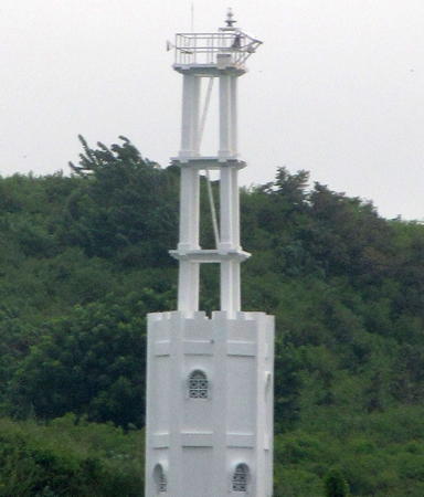
2012 (station established 1983). Active; focal plane 52 m (171 ft); white flash every 3 s. 15 m (49 ft) 2-stage tower, including a square skeletal tower mounted atop an octagonal white concrete tower. Trabas has Cameron's closeup photo (also seen at right), the tower is at the far right of Phermana Rendy's view from the sea and Google has a satellite view. NGA lists this light as "Labuan Tring Bay." Located on a steep promontory on the west side of the entrance to Labuan Tereng Bay and Lembar. Site status unknown. DSI-4184; Admiralty Q1297; NGA 25568.
[Port Pertamina Patra Niaga]
Date unknown. Active; focal plane about 18 m (59 ft); white light, pattern unknown. Approx. 15 m (49 ft) mast. Eko Prasetyo has a 2018 photo and Bing has a satellite view. Located beside the pier of an LPG terminal in the southwest corner of Labuan Tereng Bay. Site status unknown. Admiralty Q1298.48.
Kramat Port
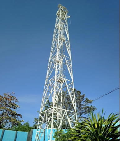
1996. Active; focal plane 18 m (59 ft); red flash every 3 s. 18 m (59 ft) square pyramidal skeletal tower mounted on a square platform supported by piles. Tower painted red. Trabas has Cameron's photo and Google has a satellite view and a distant street view. Located on a shoal in the entrance to the inner harbor of Lembar. Accessible only by boat. Site open, tower closed. DSI-4185; Admiralty Q1298.4; NGA 25564.
Kramat Starboard (2)
Date unknown. Active; focal plane 18 m (59 ft); green flash every 3 s. 16 m (52 ft) square pyramidal skeletal tower mounted on a square platform supported by piles. Tower painted green. A 2021 photo is available, Lingsarwiadi Patra has a view from the bay, and Google has a satellite view. Located on a shoal in the entrance to the inner harbor of Lembar. Accessible only by boat. Site open, tower closed. DSI-4183; Admiralty Q1298.44.
Kramat East Port
2008 (station establsihed 1986). Active; focal plane 18 m (59 ft); red flash every 4 s. 18 m (59 ft) square pyramidal skeletal tower mounted on a square platform supported by piles. Tower painted red. Trabas has Cameron's photo, Ketut Ardi Wijaya has a sea view, and Google has a satellite view. Located about 300 m (0.2 mi) northeast of the Kramat Port light. Accessible only by boat. Site open, tower closed. DSI-4185.1; Admiralty Q1298.35; NGA 25565.5.

Tanjung Bunutan Light, Lembar
photo copyright Douglas Cameron; used by permission
Kramat East Starboard
1996. Active; focal plane 15 m (49 ft); green flash every 3 s. 13 m (43 ft) square metal skeletal tower mounted on a square platform supported by piles. Tower painted green. Trabas has Arndt's photo and Google has an indistinct satellite view. Located about 500 m (0.3 mi) east northeast of the Kramat Starboard light. Accessible only by boat. Site open, tower closed. DSI-4185.2; Admiralty Q1298.3; NGA 25565.
Pelabuhan Lembar (2)
2015 (station established 1980). Active; focal plane 25 m (82 ft); white flash every 3 s. 15 m (49 ft) 2-stage tower, including a square skeletal tower mounted atop a white concrete tower, very similar to the Tanjung Bunutan light shown above. Google has a satellite view. Trabas has Arndt's view from the harbor showing a square skeletal tower, presumably the earlier light. Located on a hillside behind the port authority building in Lembar. Site status unknown. DSI-4182; Admiralty Q1298.5.
Lembar Bosowa Terminal
Date unknonw. Active; focal plane about 22 m (72 ft); white light, pattern unknown. Tripod tower atop a large round concrete silo. Rizky Firmansyah has a photo and Google has a satellite view. Located at a concrete terminal at the west end of the Lembar waterfront. Site status unknown. Admiralty Q1298.1.
Bukit Puyahan (Lembar Harbor) (2)
2013 (station established 1977). Active; focal plane 64 m (210 ft); white flash every 5 s. 15 m (49 ft) 2-stage tower, including a square skeletal tower mounted atop a white concrete tower. Mustika Marine has a 2020 distant view from the harbor and Google has a satellite view. This tower appears to be much taller than its listed height of 13 m (43 ft). Located on a hilltop on the north side of the entrance to the inner harbor of Lembar. Site status unknown. DSI-4181; Admiralty Q1298; NGA 25560.

Mataram City Lighthouse
* Ampenan (3)
2014 (station established 1897). Active; focal plane 32 m (105 ft); three white flashes, separated by 9 s, every 45 s. 30 m (98 ft) square skeletal tower painted white. Tenga Karta's photo is at right, Made Suparta has a 2022 closeup, and Google has a closeup street view and a satellite view. This tower has replaced the second (1975) lighthouse, a tapered square skeletal tower with lantern and gallery. Best Soebianto has a 2010 photo of the previous light. The first lighthouse, also a skeletal tower, had a focal plane of only 12.5 m (41 ft). Located at Ampenan, a seaside neighborhood of Mataram, the capital of West Nusa Tenggara Province. Site open, tower closed. ARLHS IDO-099; DSI-4180; Admiralty Q1296; NGA 25552.

Ampenan Light, Mataram, February 2017
ex-Google Maps street view by Tenga Karta

Lombok Barat (West Lombok) Regency: Northwest Coast Lighthouses
Santigi (Senggigi) Bay
2019. Active; focal plane 13 m (43 ft); white flash every 3 s. 13 m (43 ft) white concrete tower on a platform supported by piles. Simon Qatalum has a distant view from a nearby resort, Rahul Basu has a sunset view from the beach, and Google has a satellite view. Senggegi is a beach resort town about 16 km (10 mi) north of Matarem. Located at the edge of a shoal about 300 m (1/5 mi) off the beach at Senggegi. Accessible only by boat but easy to see from shore. Site open, tower closed. Admiralty Q1295.55.
Santigi (Senggigi) Bay North
Date unknown. Active; focal plane 13 m (43 ft); red flash every 3 s. 13 m (43 ft) red concrete tower on a platform supported by piles. Pavel Rebrov has a 2020 street view from the beach, a second street view is available, and Google has a satellite view. Located off a promontory about 1200 m (3/4 mi) northwest of the previous light. Accessible only by boat but easy to see from shore. Site open, tower closed. Admiralty Q1295.3.

Lombok Utara (North Lombok) Regency Lighthouses
* Pemanang Port
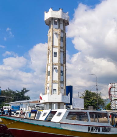
2019. Active; focal plane 20 m (66 ft); white flash every 3 s. 18 m (59 ft) octagonal cylindrical concrete tower. The tower is unpainted but darker concrete blocks along the eight angles give it the appearance of being white with light brown vertical stripes. A 2023 photo is at right, Jacek Postawa has a 2019 street view from the nearby beach and Google has a closeup street view and a satellite view. Pemanang is the ferry terminal for ferries serving the Gili Islands. Located at the foot of the ferry pier. Site open, tower closed. Admiralty Q1294.86.
Teluk Kombal (Kobal Bay)
Date unknown. Active; focal plane about 12 m (39 ft); quick-flashing white light. Approx. 12 m (39 ft) round concrete tower, upper half painted black and lower half yellow. No photo available but Bing has a satellite view. Located on a shoal halfway between Pemanang and the Gili Islands. Accessible only by boat but there should be a view from the ferries to the islands. Site open, tower closed. Admiralty Q1294.85.
* [Pulau Aer (Gili Aer)]
Date unknown. Active; focal plane about 10 m (33 ft); yellow light, pattern unknown. Approx. 8 m (26 ft) mast. Google has a street view showing the mast with a substantial seaward lean and a satellite view showing the shadow of the mast. Located on the beach at the southwest corner of Gili Aer, easternmost of the Gili Islands. Note: the word gili means "small island" in the Sasak language spoken traditionally in Lombok, so "Gili Islands" is redundant. Locally the islands are called Tiga Gili ("the Three Gilis"). Site open, tower closed. Admiralty Q1294.8; NGA 25555.5.
* Pulau Meno (Gili Meno)
Date unknown. Active; focal plane about 12 m (39 ft); light characteritics unknown. Approx. 10 m (33 ft) square skeletal tower. No photo available but Google has an indistinct satellite view. Located on the northwest coast of Gili Meno, the central island of the Gili Islands. Site probably open, tower closed. Admiralty Q1294.9; NGA 25555.
* Pulau Trawangan (Trewangan, Gili Trawangan)
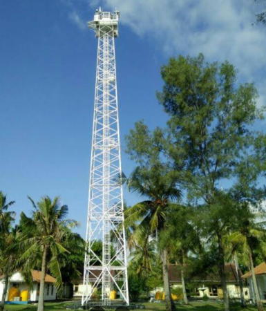
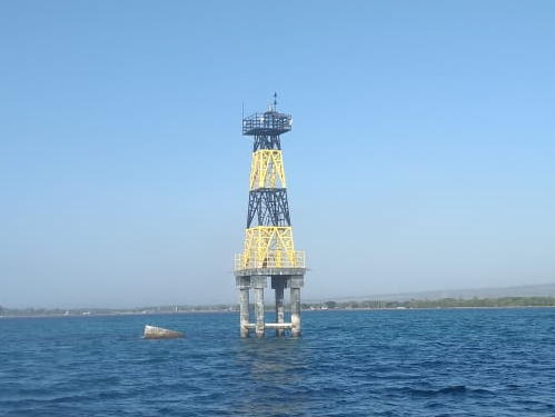
1991. Active; focal plane 43 m (141 ft); two white flashes every 10 s. 40 m (131 ft) square skeletal tower with lantern and gallery, painted white. A photo is at the top of this page, Nyoman Sutapa has a sunset photo, and Google has a street view and a satellite view. This lighthouse and the Gili Selang Light on Bali frame the northern entrance to the Lombok Strait. Trawangan, westernmost and largest of the three Gili Islands, is a tourist-oriented island off the northwestern coast of Lombok. Located on the west side of the island. Accessible only by boat, but ferry transportation is available from Bali as well as from the Lombok mainland. Site open, tower closed. DSI-4178; Admiralty Q1295; NGA 25554.

Pemanang Port Light, Pemanang, August 2023
Google Maps photo by Reise- kroeten
Tanjung Agaragar
1996. Active; focal plane 35 m (115 ft); white flash every 5.5 s. 30 m (98 ft) square tapered skeletal tower with lantern and gallery, painted white. Google has a satellite view. Located near the northernmost point of Lombok. Site status unknown. DSI-4179; Admiralty Q1294.5; NGA 25551.

Lombok Timur (East Lombok) Regency (Alas Strait West Side) Lighthouses
Gili Petagan (Pulau Petagan) (2)
2004 (station established 1982). Active; focal plane 17 m (56 ft); white flash every 3 s. 17 m (56 ft) square skeletal tower with gallery, mounted on a square platform. Lighthouse painted white. Google has a satellite view. This lighthouse warns vessels away from a group of reefs and islets off the northeastern coast of Lombok; it also marks the west side of the northern entrance to the Alas Strait. Located a short distance southeast of the Petagan reef, the largest of the reefs, about 13 km (8 mi) northeast of the port of Labuhan Lombok. Accessible only by boat. Site open, tower closed. DSI-4200; Admiralty Q1301; NGA 25576.
Gili Lebur East (Karang Labuan Lombok East End)
Date unknown. Active; focal plane 6 m (20 ft) (?); red flash every 2 s. Approx. 12 m (39 ft) tower on a platform supported by piles. No photo available but Google has an indistinct satellite view. NGA has incorrect location data for this light and confuses it with Q1300.4. Also the 6 m figure is probably the tower height rather than the focal plane. Located at the end of the reef extending from Gili Lebur, on the south side of the approach to Labuan Lombok. Accessible only by boat. Site open, tower closed. Admiralty Q1300.3; NGA 25573.2.
Gili Lebur (Pulau Lebur)
1994. Active; focal plane 10 m (33 ft); quick-flashing white light. 10 m (33 ft) square skeletal tower with gallery mounted on a square platform supported by piles. Tower painted with yellow and black horizontal bands. A photo is at right, Iroel Maiden has a very distant view (this light is in the distance on the far left; the closer post light is Admiralty Q1300.4). Google has a satellite view. The light guides vessels pass a large shoal area on the south side of the approach to Lombok harbor. Located at the northern edge of the shoal. Accessible only by boat. Site open, tower closed. DSI-4199; Admiralty Q1300.2; NGA 25573.

Gili Lebur Light, Alas Strait
Directorate of Marine Navigation photo
[Tanjung Bonae]
Date unknown. Active; focal plane 8 m (26 ft); red flash every 4 s. 7 m (23 ft) red post mounted on a square platform supported by piles. Harri Daryanto has a photo, Iroel Maiden has a distant view, and Google has a satellite view. Located just off the end of the spit protecting the harbor of Labuan Lombok. Site status unknown. Admiralty Q1300.4; NGA 25573.3.
Teluk Lombok
1995. Inactive since 2023. 13 m (43 ft) square skeletal tower with gallery, mounted on a square platform supported by robust square concrete piles. Entire lighthouse painted white. Hermit Parwoto's photo is at right, a distant view is available, and Google has a satellite view. Located on a promontory sheltering the harbor of Labuan Lombok (Port Lombok), the only protected harbor on the northeastern coast of Lombok and the terminal for ferries across the Alas Strait to Sumbawa. Site status unknown, probably open. DSI-4199.2; ex-Admiralty Q1300.1; NGA 25573.5.
Labuan Lombok Entrance Channel Port Lights (3 towers)
2018-19. Active; focal plane about 10 m (33 ft); red lights, pattern unknown. Three approx. 10 m (33 ft) octagonal red concrete towers mounted on platforms supported by piles. Fendi Aprino has a photo showing two of these lights, a 2022 photo also shows two of the lights, and Google has a satellite view. Located on the south side of the narrow entrance channel to the Labuan Lombok Fishing Port. Accessible only by boat. Site open, tower closed. Not listed by the Admiralty.
Labuan Lombok Entrance Channel Starboard Lights (2 towers)
2018-19. Active; focal plane about 10 m (33 ft); green lights, pattern unknown. Two approx. 10 m (33 ft) octagonal green concrete towers mounted on platforms supported by piles. No photo available but Google has a satellite view. Located on the north side of the narrow entrance channel to the Labuan Lombok Fishing Port. Accessible only by boat. Site open, tower closed. Not listed by the Admiralty.
Teluk Lombok Light
Teluk Lombok Light, Pringgabaya, May 2010
ex-Panoramio photo copyright Hermit S. Parwoto; used by permission
Labuan Haji North Breakwater
Date unknown. Active; focal plane about 11 m (43 ft); green light, pattern unknown. This light is at the left in M. Yusuf's photo of the two breakwater lights, and Google has a satellite view. Labuhan Haji is a twon of about 50,000 residents on the southeast coast of Lombok.Accessible by walking the breakwater, although the last section is a scramble over rocks. Site open, tower closed. Not listed by the Admiralty.
Labuan Haji South Breakwater
Date unknown. Active; focal plane about 11 m (43 ft); red light, pattern unknown. 7 m (23 ft) octagonal cylindrical concrete tower painted red. Andreas Pangemanan has a photo, M. Yusuf has a photo, and Google has a satellite view. Accessible by walking the breakwater, although the last section is a scramble over rocks. Site open, tower closed. Not listed by the Admiralty.
Tanjung Ringgit (3?)
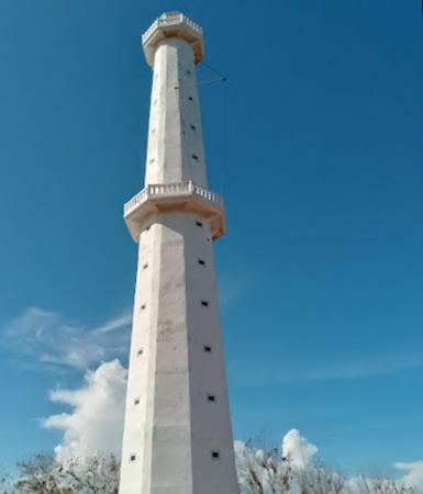
2021(?). Active; focal plane 110 m (361 ft); two white flashes every 10 s. 40 m (131 ft) octagonal concrete tower with lantern and double gallery. Several keeper's houses and other station buildings. Zahid Ansori has the January 2022 photo at right as well as a closeup photo, Sergey Filin has a 2023 photo, a YouTube video shows construction still in progress in September 2021, and Google has a satellite view. The new lighthouse replaces a square skeletal tower, painted white. Fuad Iskandar has a 2018 closeup photo of the earlier lighthouse and Google has a January 2015 street view and a closeup street view of the station gate; Bing has a satellite view. In 2013 the Admiralty reported the lighthouse "destroyed" and replaced by a temporary beacon. However, it's possible that only the lantern was removed and replaced by a modern beacon. The lighthouse is surrounded by a national forest reserve. Located on a promontory at the southeastern tip of Lombok, marking the southern entrance to the Alas Strait. Site status unknown. Site manager: Tanjung Ringgit Eco Region. ARLHS IDO-326; DSI-4198; Admiralty Q1300; NGA 25572.

Teluk Ringgit Light, Lombok Timur, January 2022
Google Maps photo by Zahid Ansori

Lombok Tengah (Central Lombok) Regency: South Coast Lighthouse
#Tanjung Bungkulan (Tanjung Awang, Ekas Bay)
1998. Removed around 2020 but still listed with focal plane 95 m (312 ft); white flash every 5 s. This was a 30 m (98 ft) square pyramidal skeletal tower with lantern and gallery, painted white. Google has a satellite view of the locaion. Note: There is another Tanjung Bungkulan lighthouse in Bali. Located on a sharp promontory on the west side of the entrance to Teluk Awang (Ekas Bay), about 35 km (22 mi) west of Tanjung Ringgit. Site status unknown. DSI-4295; Admiralty Q1299.3; NGA 25571.5.

Information available on lost lighthouses:

Notable faux lighthouses:

Adjoining pages: East: Sumbawa | West: Bali

Return to the Lighthouse Directory index | Ratings key

Posted January 10, 2009. Checked and revised September 20, 2023. Lighthouses: 33. Site copyright 2023 Russ Rowlett and the University of North Carolina at Chapel Hill.