Lighthouses of Indonesia: Madura

The Republic of Indonesia has been independent since 1945, after having been the Dutch East Indies for more than 350 years. It is a huge country, stretching along both sides of the Equator for more than 46 degrees of longitude (roughly 5100 km or 3200 miles). Comprised of some 17,000 islands (more than 6000 inhabited islands), it has hundreds of major aids to navigation.

Madura is a large island off the northeastern coast of Java. The island, roughly 130 km (80 mi) long east to west and up to 35 km (22 mi) wide, is separated from Java by the Madura Strait. At its western end the strait is quite narrow and is crossed by the 5.4 km (3.4 mi) long Suramadu Bridge. On the south side of Madura, however, the strait is a broad sound up to 80 km (50 mi) wide. Madura has a population of roughly 4 million.

Indonesia is divided into 38 provinces (provinsi) and the provinces are subdivided into county units called regencies (kabupaten). Madura is included as part of East Java (Jawa Timur) Province; the other lighthouses of that province are described on the Eastern Java page. Madura is divided into four regencies. Sumenep Regency, located at the east end of Madura, includes the outlying Masalembu, Sapudi, and Kangean Islands.

More than 700 languages are spoken in Indonesia. The official national language, Indonesian (Bahasa Indonesia), was standardized from a form of Malay that served as a lingua franca across the archipelago. In Indonesian a lighthouse is a mercusuar or a menara suar. Tanjung is a cape, ujung is a headland or point of land, bukit is a hill, sungai is a river, kuala or muara is an estuary or river mouth, pulau is an island, karang is a reef, batu is a rock, laut is a sea, selat is a strait, teluk is a bay, pelabuhan is a harbor, and labuhan is a port.

The original Dutch names of historic lighthouses, if known, are shown in curly brackets {}.

Aids to navigation in Indonesia are operated and maintained by the Directorate of Marine Navigation within the Directorate General of Sea Transportation

ARLHS numbers are from the ARLHS World List of Lights. Admiralty numbers are from volume Q of the Admiralty List of Lights & Fog Signals. U.S. NGA List numbers are from Publication 112.

General Sources
Leuchttürme in Indonesien
Photos posted by Andreas Köhler.
Lighthouses in Indonesia
Wikimedia photos, including a collection of historic photos from the collection of the Tropenmuseum in Amsterdam.
World of Lighthouses - Indonesia
Photos by various photographers available from Lightphotos.net.
Online List of Lights - Indonesia
Photos by various photographers posted by Alexander Trabas. The Madura photos are by Jim Smith.
Indonesian Lighthouses
Historic postcard views from the collection of Michel Forand.
Leuchttürme Asiens, Australiens, und Ozeaniens auf historischen Postkarten
Historic postcard views posted by Klaus Huelse.
Navionics Charts
Navigation chart for Madura.

Pulau Sapudi Light, Sapudi Islands, October 2022
Google Maps photo by Ismaya Kenza

Bangkalan Regency (Western Madura) Lighthouses

Madura Strait Lighthouses
Kessek
Date unknown. Active; focal plane 23 m (75 ft); three white flashes every 12 s. 20 m (66 ft) square white skeletal tower. No photo available but Google has a satellite view. This light serves as a leading light guiding vessels entering the Madura Strait from the east. Located on a wooded slope on the southwest side of Kessek, the northern terminus of the Suramadu Bridge. Site status unknown. Admiralty Q1170; NGA 23668.
Kamal (Pelabuhan Timur)
Date unknown. Inactive, probably since 2009. Approx. 15 m (49 ft) square skeletal tower mounted on a platform supported by piles. A 2018 photo is available, Pri Hinkap also has a 2018 photo, and Google has a satellite view. Kamal is the district (kecamatan) at the southwestern corner of Madura, directly across from the Tanjung Perak docks in downtown Surabaya. The light guided ferries crossing the strait, which is only about 2.5 km (1.5 mi) wide at this point. Probably it became redundant when the Suramadu Bridge opened in 2009. Located at the end of the ferry wharf in Kamal. Site status unknown but the tower is seen easily from the wharf.
Tanjungan
Date unknown. Active; focal plane 13 m (43 ft); yellow flash every 4 s. 13 m (43 ft) round barbell-shaped tower, painted yellow and mounted on a square platform supported by piles. Trabas has Smith's photo and Google has a satellite view. Located about 600 m (3/8 mi) off Tanjungan, at the narrowest passage of the Madura Strait. Accessible only by boat. Site open, tower closed. Admiralty Q1160; NGA 23627.
*** Sembilangan (Ujung Slempit) (2)
1882. Active; focal plane 53 m (174 ft: two white flashes every 10 s. 50 m (164 ft) 12(?)-sided cast iron tower with lantern and gallery. Entire lighthouse painted white. Lawrence Eka's photo is at right, Trabas has Smith's photo, Haryono Cokro has a 2008 photo, Erfan Kan has a 2022 photo, the Tropenmusuem has a historic photo, and Google has a closeup street view and a good satellite view. There was at least a partial restoration of the lighthouse in 2010. Located on the extreme western tip of Madura, this is both a landfall light and the rear light of a range guiding ships into the channel between Madura and Java to approach the port of Surabaya. Accessible by road from Bangkalan, Madura. Site open, tower open although we do not know the schedule. . ARLHS IDO-079; Admiralty Q1158.2; NGA 23624.
Tanjung Piring (Madura Entrance Range Rear)
Date unknown. Active; focal plane 14 m (46 ft); white flash every 3 s. 14 m (46 ft) square skeletal tower with gallery, painted white. Trabas has Smith's photo and Google has a satellite view. The listed focal plane seems to be too low. The Admiralty now lists this light as the rear light and no longer has the Sembilangan lighthouse as an official part of the range. Located on the low cape on the east side of the northern entrance to Madura Strait. Site status unknown. Admiralty Q1158.1; NGA 23620.
Mapia (Madura Entrance Range Front)
Date unknown. Active; focal plane 14 m (46 ft); white flash every 3 s. 14 m (46 ft) post mounted on a square concrete platform supported by piles. Lighthouse painted with red and white horizontal bands. Trabas has Smith's photo but the light is not shown in Bing's satellite view. Located 5.1 km (3.2 mi) north northeast of Tanjung Piring. Accessible only by boat. Site open, tower closed. Admiralty Q1158; NGA 23616.
Sembilangan Light
Sembilangan Light, Pernajuh, June 2011
ex-Panoramio photo by Lawrence Eka; used by permission
Pulau Karangjamuang (1)
1971. Inactive since about 2011. Approx. 30 m (98 ft) tapered square skeletal tower painted white. Trabas has Smith's photo, Anoeng Suroboyo's view from the sea shows both lighthouses, Ariedwisoebekto Kariman has a photo in which this older lighthouse can be seen behind the present lighthouse. Located on a small island at the northeastern entrance to the Madura Strait about 13 km (8 mi) north of Bangkalan. Accessible only by boat. Site status unknown.
Pulau Karangjamuang (2)
2016 (station established 1971). Active; focal plane 41 m (135 ft); white flash every 4 s. 40 m (131 ft) octagonal concrete tower with lantern and double gallery, painted white. Trabas has Smith's photo (also seen at right), Ariedwisoebekto Kariman has a photo, Anoeng Suroboyo's view from the sea shows both lighthouses, and Google has a satellite view. Located on a small island at the northeastern entrance to the Madura Strait about 13 km (8 mi) north of Bangkalan. Accessible only by boat. Site status unknown. ARLHS IDO-065; Admiralty Q1157.5; NGA 23612.

North Coast Lighthouses
* Telaga Biru
Date unknown. Active; focal plane about 12 m (39 ft); white light, pattern unknown. Approx. 11 m (36 ft) white post on a platform supported by piles. The light appears at 0:10 in a video and Google has a street view and an indistinct satellite view. Located on the beach at Telaga Biru in the northeastern corner of Bangkalan Regency. Site open, tower closed. Admiralty Q1243.6.
Sapulu (Sepulu)
Date unknown. Active; focal plane 10 m (33 ft); yellow flash every 2 s. 10 m (33 ft) round barbell-shaped tower mounted on a platform supported by piles. Google has a satellite view and a distant street view. Although the Admiralty lists this light as Sapulu it is actually 17 km (10.5 mi) east of that town. Located in the entrance to an open bay in the eastern Tanjungbumi District about 5 km (3 mi) east of Telaga Biru. Accessible only by boat. Site open, tower closed. Admiralty Q1243.5; NGA 23751.

Pulau Karangjamuang Light, Bangkalan
photo copyright Jim Smith; used by permission

Sumenep Regency Lighthouses

The Sumenep Regency includes the eastern end of Madura and a large group of smaller islands lying to the northeast and east.

Northeast Madura Lighthouses
[Pasongsongan West]
Date unknown. Active; focal plane about 13 m (43 ft); green light, pattern unknown. Approx. 13 m (43 ft) post on a platform supported by piles. No photo available but Google has a satellite view. Located off the end of the west breakwater at Pasongsongan. Accessible only by boat but easy to see from shore. Site open, tower closed. Admiralty Q1243.1.
[Pasongsongan West]
Date unknown. Active; focal plane about 13 m (43 ft); red light, pattern unknown. Approx. 13 m (43 ft) post on a platform supported by piles. Jayanti Nur Fatimah has a photo and Google has a satellite view. Located off the end of the east breakwater at Pasongsongan. Accessible only by boat but easy to see from shore. Site open, tower closed. Admiralty Q1243.05.
Batu Putih (Batuputih)
Date unknown. Active; focal plane 53 m (174 ft); two white flashes every 15 s. Approx. 40 m (131 ft) square skeletal tower with lantern and gallery. Several coast guard station buildings. Lighthouse painted white, lantern red. Google has the street view seen at right and a satellite view. The name of the lighthouse means "white stone." This lighthouse is on the northeastern "shoulder" of Madura, helping to guide ships around the east end of the island. Located about 4 km (2.5 mi) east of the village of Batuputih. Site status unknown. ARLHS IDO-092; Admiralty Q1243; NGA 23750.

Batuputih Light, Batuputih, August 2015
Google Maps street view

Masalembu Islands Lighthouses
The Masalembu Islands are a small group in the middle of the Java Sea about 160 km (100 mi) northeast of Madura (halfway to Borneo). The islands have a population of about 22,000; boat transportation is available from Sumenep.
* Masalembu (Masalembo) Besar
Date unknown. Active; focal plane 200 m (656 ft); three white flashes every 21.5 s. 40 m (131 ft) skeletal tower with lantern and gallery, painted white; lantern painted red. Heru Purwanto has a 2018 photo, Ahmad Shiddiqi has a 2022 photo, Andreas Pambudi has a closeup, Bung Fadil has a view from the gallery and Google has a satellite view. Located atop the largest and southernmost of the Masalembu Islands. Site open and daredevil visitors can climb the tower. ARLHS IDO-011; Admiralty Q1424; NGA 23592.
Masalembu (Masalembo) Besar Southwest
Date unknown. Active; focal plane 14 m (46 ft); red flash every 6 s. 14 m (46 ft) square skeletal tower with gallery, painted red and mounted on a square platform supported by four massive concrete piles. A photo by Said Masalboys is at right and Google has a distant satellite view. Located in an embayment off the harbor of Pulau Masalembu. Accessible only by boat. Site open, tower closed. Admiralty Q1424.5; NGA 23593.
* Pelabuhan Masalembu (Masalembo)
Date unknown. Active; focal plane 24 m (79 ft); white flash every 5 s. 20 m (66 ft) square white skeletal tower. Hisam Naim has a photo and Google has a satellite view. Located at the base of the pier of the ferry terminal on the south side of Pulau Masalembu Besar. Site open, tower closed. Admiralty Q1424.7.
Pulau Karamian (Keramian, Karamaian)
Date unknown. Active; focal plane 16 m (52 ft); white flash every 5 s. 15 m (49 ft) square white skeletal tower. This is a staffed coast guard station. No photo available but Google has an indistinct satellite view of the station. Karamian is a remote island 50 km (30 mi) north of Masalembu Besar and only 100 km (60 mi) south of the coast of Kalimantan (Borneo), but it is inhabited by about 4000 people of Maduran ethnicity. Located at the northern tip of the island. Site status unknown. Admiralty Q1426; NGA 23604.
Masalembu Besar Southwest Light
Masalembu Besar Southwest Light, Masalembu Islands, September 2010
ex-Panoramio Creative Commons photo by Said Masalboys

Sapudi Islands Lighthouses
The Sapudi Islands extend eastward from the east end of Madura. Pulau Sapudi, the westernmost of the islands, is also the largest. The islands have a population of about 85,000.
Pulau Sapudi (Trebung, Tribung) {Pulau Sapoedi}
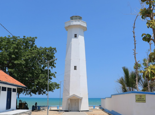
1887. Active; focal plane 59 m (194 ft); white flash every 5 s. 58 m (190 ft) octagonal skeletal cast iron tower with lantern, gallery, enclosed watch room, and central cylinder. Entire lighthouse painted white. Ismaya Kenza's photo is at the top of this page, Dedy Grezt has a 2020 photo, Guntur Sugiatmo has a 2017 photo, the Tropenmuseum has historic photos, and Google has a satellite view of the light station. Located at the west point of Sapudi, the island lying to the east of Madura, marking the passage between the two islands. Site status unknown. ARLHS IDO-091; Admiralty Q1240; NGA 23744.
* Gayam
Date unknown. Active; focal plane 15 m (49 ft); white flash every 5 s. 12 m (39 ft) robust mast oprojecting through a 1-story building and carrying a large daymark panel. Haidir Ali has a 2023 photo and Google has a satellite view. Located near the base of the pier of the ferry terminal at Gayam, on the southwest coast of Pulau Sapudi. Site open, tower closed. Admiralty Q1241; NGA 23746.
* Pelabuhan Ra'as
Date unknown (recent). Active; focal plane about 40 m (131 ft); white light, pattern unknown (probably flash every 5 s). Approx. 40 m (131 ft) square white skeletal towwr. Muhamad Habibi's 2021 photo is at right, Ach Ady Soefriyanto has a 2018 photo, and Google has a satellite view. Pulau Ra'as is the second largest of the Sapudi islands, located near the eastern end of the group. Located at the terminal at the east end of a long pier extending from the east end of Pulau Ra'as. Site open, tower closed. Remarkably, this major lighthouse is not listed by the Admiralty.
Pulau Kamudi (Kemudi)
Date unknown. Active; focal plane 17 m (56 ft); white flash every 5 s. 17 m (56 ft) white concrete tower with gallery. A small view from the sea is available and Bing has a satellite view of the station. NGA lists the light as "Punta Kamudi." Located on a reef at the extreme eastern end of the Sapudi Islands. Accessible only by boat. Site status unknown. ARLHS IDO-093; Admiralty Q1244; NGA 23752.

Pelabuhan Ra'as Light, Sapudi Islands, October 2021
Google Maps photo by Muhamad Habibi
Karang Takat
Date unknown. Active; focal plane 14 m (46 ft); white flash every 2 s. 14 m (46 ft) "white beacon," probably a white fiberglass tower, mounted on a platform supported by piles. No photo available but Bing has a distant satellite view. Located at the west end of a large reef halfway between Pulau Kamudi and Pulau Kangean. Accessible only by boat. Site open, tower closed. Admiralty Q1244.5; NGA 23754.

Kangean Islands Lighthouses
The Kangean Islands are an archipelago northeast of Bali and about 120 km (75 mi) east of Madura. They are well populated with a total of about 125,000 residents.
* Pulau Mamburit
Date unknown. Active; focal plane 45 m (148 ft); white flash every 5 s. Approx. 42 m (138 ft) square skeletal tower with gallery, painted white. Four coast guard station buildings. A photo is at right, Amin Aghaf has a 2021 photo, a 2020 closeup is available, the tower is at far right in a distant view by Ainur Rahman, and Google has a satellite view of the station. Located at the north end of a small island off the northwest end of Pulau Kangean, the largest of the Kangean Islands. Site open, tower closed. Admiralty Q1244.9; NGA 23762.
* [Tanjung Tinggi (Batu Guluk)]
Date unknown. Active; focal plane about 14 m (46 ft); white light, pattern unknown. Approx. 12 m (39 ft) mast on a concrete platform supported by piles. Yusron Bastian has a photo and the mast is at the corner of the quay in Google's satellite view. Located on the waterfront of Batu Guluk, a small port at the northwest end of Pulau Kangean. Site open, tower closed. Admiralty Q1244.95.
Ketapang Bay
Date unknown. Active; focal plane 16 m (52 ft); white flash every 5 s. 16 m (52 ft) skeletal tower with gallery, painted white and mounted on a square platform supported by piles. No photo available but Google has a satellite view. Located in a bay at the west end of Pulau Kangean, about 2.5 km (1.5 mi) southeast of Pulau Mamburit. Accessible only by boat. Site open, tower closed. Admiralty Q1245; NGA 23756.
* [Pulau Sapeken]
Date unknown. Active; focal plane about 14 m (46 ft); white light, pattern unknown. Approx. 12 m (39 ft) mast on a concrete platform supported by piles. Agung Budi Prabowo has a photo, Ahmad Fatkurohman has a night photo, and Bang Ibe has a 2021 photo, but the mast is hard to find in Google's satellite view. Located at the foot of the pier at Pulau Sapeken, a small but densely populted island just off the northeastern tip of Pulau Kangean. Site open, tower closed. Admiralty Q1248.
Pulau Mamburit Light
Pulau Mamburit Light, Kangean Islands, October 2010
ex-Panoramio photo by onatali; permission requested
Pulau Saibus (Saebus)
Date unknown. Active; focal plane 22 m (72 ft); white flash every 6 s. Approx. 19 m (62 ft) square skeletal tower with lantern and gallery, painted white and mounted on a square 1-story building. A 2022 photo is available, Lina Nofera has a 2022 photo, and Google has a satellite view. Pulau Saibus is off the southeastern tip of Pulau Paliat and northwest of Pulau Sepanjang, on the west side of the narrow passage through the Kangean Islands. Located at the base of the pier at the east end of the island. Site status unknown. Admiralty Q1246.3; NGA 23771.
Pulau Pagerungan Kecil
Date unknown. Active; focal plane 10 m (33 ft); 10 m (33 ft) round white barbell-shaped tower. No photo available but Bing has a fuzzy satellite view. Located on a reef off the northeast side of Pulau Pagerungan Kecil, a small island on the northeast end of the Kangean Islands. Accessible only by boat. Site open, tower closed. Admiralty Q1246.7.
Pulau Sesiil (2?)
Date unknown. Active; focal plane 10 m (33 ft) (?); two white flashes every 8 s. Approx. 16 m (52 ft) mast mounted on a platform supported by piles. No photo available but Bing has a satellite view. The focal plane listed is too low. Located just off a reef at the northeastern tip of Pulau Sepanjang, marking the east side of the narrow passage through the Kangean Islands. Accessible only by boat. Site open, tower closed. Admiralty Q1248.5; NGA 23770.
Pulau Sepanjang
Date unknown. Active; focal plane 44 m (144 ft); white flash every 4 s. Approx. 40 m (131 ft) square tapered skeletal tower with lantern and gallery, painted white. Several coast guard station buildings. Satria Handrianto has the 2022 photo seen at right, Amien Al-hasni has a view from the gallery, and Google has a satellite view of the station. Located at the southeastern tip of Pulau Sepanjang, the second largest of the Kangean Islands. Site status unknown. ARLHS IDO-095; Admiralty Q1246.5; NGA 23768.
Pulau Sekala (1)
Date unknown. Inactive. 40 m (131 ft) tapered square skeletal tower, painted white. Agus Sejati has a photo and Bing has a satellite view of the station. Pulau Sakala is the easternmost of the Kangean Islands and the easternmost territory of East Java Province. The island has a population of about 2500. Located at the eastern tip of the island. Accessible only by boat. Site status unknown.
Pulau Sekala (2)
Date unknown. Active; focal plane 46 m (151 ft); three white flashes every 20 s. 40 m (131 ft) octagonal white concrete tower with lantern and gallery. Agus Sejati has a 2020 photo. Located at the eastern tip of the island. Accessible only by boat. Site status unknown. ARLHS IDO-094; Admiralty Q1247; NGA 23764.

Pulau Sepanjang Light, Kangean Islands, July 2022
Google Maps photo by Satria Handrianto

Southeast Madura Lighthouses
* [Dungkek]
Date unknown. Active; focal plane about 12 m (39 ft); white light, pattern unknown. Approx. 10 m (33 ft) white mast. Nasrul Irianto Zainuddin has a 2021 photo but the mast is not seen in Google's satellite view. Located at the end of a long pier at Dungkek, a town of about 35,000 residents southwest of Tanjung Lapa, the eastern tip of Madura. Accessible by walking the pier. Site open, tower closed. Admiralty Q1238.3.
Pulau Puteran
Date unknown. Active; focal plane about 15 m (49 ft); light characteristic unknown. Approx. 15 m (49 ft) round barbell-shaped fiberglass tower mounted on a platform supported by piles. No closeup photo available but Google has a satellite view. The light can be seen on the right side of the strait in a photo by Achmad Syauqi Ramadhani. Pulau Puteran is an island about 15 km (8 mi) long and 4 km (2.5 mi) wide just off the eastern tip of Madura; it is separated from the mainland at its northwestern tip by a strait barely 200 m (220 yd) wide. The lighthouse is just offshore in the strait, directly opposite the Kaliangat waterfront. Site open, tower closed. Admiralty Q1238.2.
Kaliangat North Range Rear
Date unknown. Active; focal plane 12 m (39 ft); white flash every 3 s. 10 m (33 ft) white skeletal tower. No photo but Google has an indistinct satellite view. Located on one of the quays at Kaliangat, a town of about 40,000 residents and the port associated with Sumenep, the regency capital. Site and tower closed. Admiralty Q1238.1; NGA 23740.
* [Kaliangat South Range Front]
Date unknown. Active; focal plane 10 m (33 ft); continuous green light. 8 m (26 ft) square pyramidal white skeletal tower. Google has a street view and a satellite view. Located on the waterfront at Kaliangat,. Site open, tower closed. Admiralty Q1236; NGA 23728.
* Kaliangat South Range Rear
Date unknown. Active; focal plane 18 m (59 ft); continuous red light. 13 m (43 ft) square pyramidal white skeletal tower. Google has a closeup street view and an indistinct satellite view. Located 146 m (160 yd) northeast of the front light, near a mosque. Site open, tower closed. Admiralty Q1236.1; NGA 23732.
* Tanjung Madura (Tanjung Saronggi) (2?)
Date unknown. Active; focal plane 18 m (59 ft); white flash every 3 s. 13 m (43 ft) white concrete tower. A portion of Aulia Hanif's photo is at right, Ody Anjar has a closeup photo, Widiyanti S. Sufia has another 2018 photo, and Google has a satellite view. NGA lists a skeletal tower at this location. More information is needed about this station; according to research by Michel Forand the station was established by 1917 but the light has always been described as a skeletal tower. The location is known locally simply as Tanjung and the Admiralty lists the light oddly as Tanjung Tanjung ("Cape Cape"). Located at the southeastern tip of Madura. Accessible by road. Site open, tower closed. ARLHS IDO-162; Admiralty Q1232; NGA 23724.
Gili Genteng (Pulau Giligenteng) (1 and 2)
Date unknown. Active; focal plane 15 m (49 ft); three white flashes every 15 s. 11 m (36 ft) white tower on a platform supported by piles. No photo available. Google's satellite view shows that this lighthouse has been replaced by a post on a new platform about 30 m (100 ft) west of the former platform. Gili Genteng is an inhabited island in the Madura Strait off the southeastern coast of Madura. Note: gili is the Madurese word for "island," so "Pulau Giligenteng" is redundant. Located about 300 m (0.2 mi) off the western tip of Gili Genteng. Accessible only by boat. Site open, tower closed. Admiralty Q1230; NGA 23720.
Gili Raja (Pulau Giliraja)
Date unknown. Active; focal plane 42 m (138 ft); white flash every 6 s. Approx. 20 m (66 ft) mast centered on a round white concrete tower. No photo available but Google has a satellite view. Gili Raja is an inhabited island in the Madura Strait off the southeastern coast of Madura a few miles west of Gili Genteng. Located at the east end of the island. Site status unknown. ARLHS IDO-090; Admiralty Q1228; NGA 23718.

Tanjung Madura Light, Sumenep, October 2018
ex-Google Plus photo by Aulia Hanif
Gili Dua (Pulau Gilidua)
Date unknown. Active; focal plane 20 m (66 ft); white flash every 3 s. 20 m (66 ft) "white beacon" mounted on a platform supported by piles. No photo available and the light is not shown in Google's satellite view. Located on a reef about 15 km (9 mi) west of Gili Raja and the same distance off the south coast of Madura. Accessible only by boat. Site open, tower closed. Admiralty Q1226; NGA 23716.

Pamekasan and Sampang Regencies: South Coast and Central Madura Strait Lighthouses

Pamekasan Regency South Coast Lightbeacon
* [Branta Pesisir (Branta Pamekasan)]
Date unknown. Active; focal plane about 12 m (39 ft); white light, pattern unknown. Approx. 10 m (33 ft) white mast. Andi Kuadrat has a 2021 photo and Google has a satellite view. Located on the pier at Branta. Accessible by walking the pier. Site open, tower closed. Admiralty Q1225.8.

Sampang Regency South Coast
Lighthouses
Camplong East
Date unknown. Active; focal plane 24 m (79 ft); white flash every 5 s. 21 m (69 ft) square skeletal tower. Google has a street view and a satellite view. Located on the quay of the Pt. Garam Terminal on the east side of Camplong. Site status unknown. Admiralty Q1225.5; NGA 23715.
* Camplong
Date unknown. Active; focal plane 21 m (69 ft); four white flashes every 20 s. 19 m (62 ft) square skeletal tower with gallery, covered by white metal panels. Detta Priyandikawardhana's photo is at right, and Google has a satellite view. Located near an oil terminal at Camplong on the central south coast of Madura. Site open, tower closed. ARLHS IDO-089; Admiralty Q1225; NGA 23714.
[Tanglok Sampang]
Date unknown. Active; focal plane about 12 m (39 ft); white light, pattern unknown. Approx. 12 m (39 ft) mast mounted on a platform supported by piles. Kawit Gigi has a photo and Google has a satellite view. Located on the east side of the entrance to the Sampang River. Site status unknown. Admiralty Q1224.9.
* [Pulau Mandangin (Pulau Kambing)]
Date unknown. Active; focal plane about 15 m (49 ft); white light, pattern unknown. Approx. 12 m (39 ft) white mast. Haris Muhammad has a photo but the mast is hard to see in Google's satellite view. Located at the base of the pier of Pulau Mandangin, a small but densely populated island off the southwest coast of Sampang Regency Site open, tower closed. Not listed by the Admiralty.
Camplong Light
Camplong Light, July 2010
ex-Panoramio photo by Detta Priyandikawardhana

Central Madura StraitLighthouses
Karang Manila
Date unknown. Active; focal plane 12 m (39 ft); two white flashes every 12 s. 12 m (39 ft) "beacon," probably a skeletal tower on a platform supported by piles, painted black with one red horizontal band. No photo available and the lighthouse is not shown in Google's satellite view. Located on a reef in the Madura Strait about 10 km (6 mi) southwest of Pulau Kambing. Accessible only by boat. Site open, tower closed. Admiralty Q1197; NGA 23670.
Karang Koko (Madura Strait, Zwaantjes Reef) {Zwaantjes Droogte} (2)
Date unknown (station established 1871). Active; focal plane 18 m (59 ft); three white flashes every 13 s. 16 m (52 ft) tower mounted on a round pier. Lighthouse painted black with one red horizontal band. No photo available but Bing has a satellite view. Forand has a historic photo of the original Dutch lighthouse; a Java Post article from April 2012 has additional photos and information about the lighthouses of this unusual class. Located on a dangerous reef in the Madura Strait about 25 km (15 mi) northeast of Pasuruan. Accessible only by boat. Site open, tower closed. ARLHS IDO-145; Admiralty Q1200; NGA 23676.
Batu Sirumpa (Karang Sirumpa, Sirumpa Rock)
Date unknown. Active; focal plane 16 m (52 ft); two white flashes every 10 s. 16 m (52 ft) beacon, probably a fiberglass tower, painted black with one red orizontal band. No photo available but Bing has a distant satellite view. Located in the center of the Madura Strait about 11 km (7 mi) northwest of Karang Koko. Accessible only by boat. Site open, tower closed. Admiralty Q1198; NGA 23672.

Information available on lost lighthouses:

Notable faux lighthouses:

Adjoining pages: North: Kalimantan (Borneo) | West: Eastern Java

Return to the Lighthouse Directory index | Ratings key

Posted April 13, 2006. Checked and revised August 24, 2023. Lighthouses: 41. Site copyright 2023 Russ Rowlett and the University of North Carolina at Chapel Hill.