Lighthouses of Indonesia: South Kalimantan

The Republic of Indonesia has been independent since 1945 after having been the Dutch East Indies for more than 350 years. It is a huge country, stretching along both sides of the Equator for more than 46 degrees of longitude (roughly 5100 km or 3200 miles). Comprised of some 17,000 islands (more than 6000 inhabited islands), it has hundreds of major aids to navigation.

Borneo, known as Kalimantan in Indonesia, is the world's third largest island. 73% of the island is Indonesian; the remaining portion includes the Malaysian states of Sarawak and Sabah and the independent sultanate of Brunei. Indonesian Kalimantan is separated from Sulawesi (Celebes) to the east by the Makassar Strait, from Java to the south by the Java Sea, and from Sumatra to the southwest by the Karimata Strait and Natuna Sea.

Indonesia is divided into 38 provinces (provinsi) and the provinces are subdivided into county units called regencies (kabupaten). This page describes lighthouses of southeastern Kalimantan in South Kalimantan Province. The province has coasts facing east on the Makassar Strait and south on the Java Sea.

More than 700 languages are spoken in Indonesia. The official national language, Indonesian (Bahasa Indonesia), was standardized from a form of Malay that served as a lingua franca across the archipelago. In Indonesian a lighthouse is a mercusuar or a menara suar. Tanjung is a cape, ujung is a headland or point of land, bukit is a hill, sungai is a river, kuala or muara is an estuary or river mouth, pulau is an island, karang is a reef, batu is a rock, laut is a sea, selat is a strait, teluk is a bay, pelabuhan is a harbor, and labuhan is a port.

Aids to navigation in Indonesia are operated and maintained by the Directorate of Marine Navigation within the Directorate General of Sea Transportation

ARLHS numbers are from the ARLHS World List of Lights. DSI numbers are Indonesian light list numbers, where known. Admiralty numbers are from volumes F and Q of the Admiralty List of Lights & Fog Signals. U.S. NGA List numbers are from Publication 112.

General Sources
Online List of Lights - Indonesia - Kalimantan
Photos by various photographers posted by Alexander Trabas.
Indonesian Lighthouses
Historic postcard views from the collection of Michel Forand.
World of Lighthouses - Indonesia
Photos by various photographers available from Lightphotos.net.
GPSNauticalCharts
Navigational chart information for South Kalimantan.
Navionics Charts
Navigation chart for southern Kalimantan.

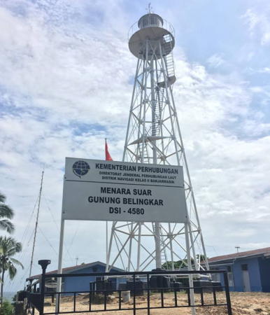
Gunung Belingkar Light, Kotabaru, January 2018
Google Maps photo by Wijaya Yoga
Kotabaru Regency: Makassar Strait Lighthouses
Karang Grogot
Date unknown. Active; focal plane 15 m (49 ft); white flash every 8 s. 15 m (49 ft) beacon on a platform supported by piles. NGA lists it as white but Navionics charts it as black with a red horizontal band. No photo available and the light is not shown in Google's satellite view. Located on a shoal about 20 km (13 mi) southeast of Tanjung Pamukan. Accessible only by boat. Admiralty Q1447; NGA 24940.
Karang Demung
Date unknown. Active; focal plane 14 m (46 ft); two white flashes every 10 s. 14 m (46 ft) beacon painted black with a red horizontal band. and mounted on a platform supported by piles. No photo available and the light is not shown in Google's satellite view. Located on a shoal about 40 km (25 mi) southeast of Tanjung Pamukan. Accessible only by boat. Admiralty Q1446.5; NGA 24941.
Pulau Larilarian (Lari Larian)
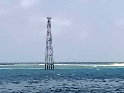
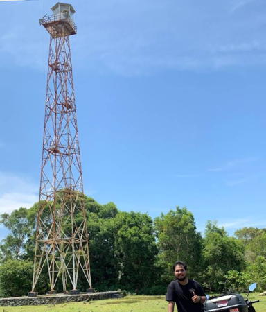
2007(?). Active; focal plane 32 m (105 ft); white flash every 5 s. 32 m (105 ft) skeletal tower, painted white, on a platform suppirted by piles. Ahmad Kaykhan's photo is at right and the tower is not seen in Bing's fuzzy satellite view. This island was claimed by South Kalimantan and East Sulawesi provinces; a 2011 ruling by the Indonesian Supreme Court confirmed South Kalimantan's jurisdiction. Located just off an isolated island in Makassar Strait about 145 km (90 mi) due east of Pulau Laut. Accessible only by boat. Site status unknown. ARLHS IDO-212; Admiralty Q1445; NGA 24947.
Perasabasah Shoal (Gosong Perasabasah)
Date unknown. Active; focal plane 12 m (39 ft); white flash every 5 s. 13 m (43 ft) "white beacon," probably a skeletal tower. No photo available and Google has only a fuzzy satellite view of the shoal. Located on a reef about 5 km (3 mi) offshore and 25 km (15 mi) north of the northern tip of Pulau Laut. Accessible only by boat. Site open, tower closed. Admiralty Q1441.

Pulau Larilarian Light, Makassar Strait, July 2020
Google Maps photo by Ahmad Kaykhan
Sambergelap (Samber Gelap, Pulau Buton Butona)
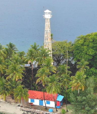
Date unknown. Active; focal plane 21 m (69 ft) (?); three white flashes every 15 s. 14 m (46 ft) (?) square skeletal tower with lantern and gallery, painted white. Aries Yulianto has a 2018 photo (also seen at right) and Bing has a satellite view. The lighthouse appears taller than the listed height. The Sambergelap Islands are a small group of islands located about 30 km (19 mi) east of Pulau Laut. The lighthouse is on the westernmost island, which also has a turtle conservation station. Ecotours to the island are available. Accessible only by boat. Admiralty Q1444; NGA 24948.

Kotabaru Regency: Pulau Laut (Kotabaru City) Lighthouses
Kotabaru is a city of about 250,000 residents. It is located on Pulau Laut ("Sea Island"), an island about 55 km (35 mi) long that lies just off the southeastern tip of Kalimantan. The northern half of the island is separated from the mainland by a narrow strait (Selat Laut, "Sea Strait"). The city is near the northern end of the island facing west on the strait. Kotabaru Regency also includes a large area on the Makassar Strait coastline north of Pulau Laut.

*
Gunung Belingkar (Balingkar Hill, Kotabaru)
1901. Active; focal plane 67 m (220 ft); white flash every 5 s. 20 m (66 ft) hexagonal pyramidal skeletal tower with lantern and gallery. Entire lighthouse painted white. Wijaya Yoga's 2018 photo is at the top of this page, Yudha Fadilah Kurniawan has a 2020 photo, Sugeng Hidayat has another photo, and Google has a satellite view. It seems likely that this is the original Dutch lighthouse, but we need information on its history. It is the landfall light for Kotabaru and it also serves as the rear light of the Tanjung Pemancingan Range. Located on a ridge in Kotabaru, near the northern tip of Pulau Laut. Site status unknown, but the lighthouse must be easy to see from nearby. . ARLHS IDO-105; DSI-4580; Admiralty Q1438.1; NGA 24956.

Sambergelap Light, Kotabaru, March 2018
ex-Google Plus photo by Aries Yulianto
Tanjung Pemancingan Range Front
Date unknown. Active; focal plane 14 m (46 ft); white flash every 5 s. 12 m (39 ft) square skeletal tower painted white and carrying a triangular daymark, point up. No photo available but Google has a fuzzy satellite view. This is an approach range for Kotabaru; the rear light is the Gunung Belingkar lighthouse. Located in the Arutmin Indonesia coal terminal on the east side near the northeastern tip of Pulau Laut. Site and tower closed. Site manager: Arutmin Indonesia. Admiralty Q1438; NGA 24952.
Selat Laut (Tanjung Pemancingan Pier Elbow)
Date unknown. Active; focal plane 12 m (39 ft); white flash every 3 s. 10 m (33 ft) square white skeletal tower. No photo available but Google has a fuzzy satellite view. Located on a short extension of the long Arutmin Indonesia coal pier, this light marks the south side of the entrance to the Selat Laut separating Pulau Laut from the mainland. Site and tower closed. Site manager: Arutmin Indonesia. Admiralty Q1438.3; NGA 24951.
Tanjung Mangkok
Date unknown. Active; focal plane 15 m (49 ft); three white flashes every 14 s. 15 m (49 ft) slender white square skeletal tower; the lower half of the tower is surrounded by metal panels. Herry Purwanto has a 2022 photo (light near the right edge) and Google has a satellite view. Located at the northeastern corner of Pulau Sebuku, an island just off the east coast of Pulau Laut. Site status unknown. Admiralty Q1444.5; NGA 24949.
Pulau Aur
Date unknown. Active; focal plane 27 m (89 ft); white flash every 4 s. Approx. 18 m (59 ft) square skeletal tower painted white. Rusli Ktb has a distant view from the sea and Google has a satellite view. Pulau Aur is a small, uninhabited island off the southeast coast of Pulau Laut and south of the much larger island of Pulau Sebuku. Located near the southern tip of the island. Accessible only by boat. Site status unknown. Admiralty Q1444.2; NGA 24987.5.
Pulau Sebuku South Point (Sekapung Jetty)
Date unknown. Active; focal plane about 15 m (49 ft); white light, pattern unknown. Approx. 15 m (49 ft) square white skeletal tower. No photo available but Google has a satellite view. Located adjoining the piers of an industrial port at the southern tip of Pulau Sebuku. Site status unknown. Admiralty Q1444.3; NGA 24987.3.
Tanjung Seloka
Date unknown. Active; focal plane 11 m (36 ft); white flash every 6 s. Approx. 9 m (30 ft) white skeletal tower. No photo available but Bing has an indistinct satellite view. Located on a headland on the southeast coast of Pulau Laut. Site status unknown. Admiralty Q1442.2; NGA 24969.
Tanjung Kunyit (Pulau Kunit)
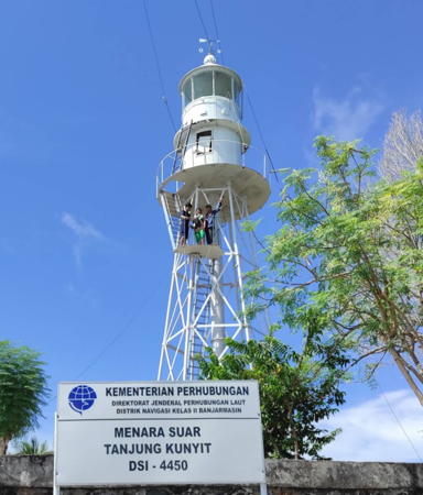
Date unknown (early 1900s). Active; focal plane 135 m (443 ft); white flash every 5 s. 13 m (43 ft) hexagonal pyramidal skeletal tower with lantern and gallery, painted white. Several 1-story coast guard station buildings. Ugi Sugiannor has the 2021 photo seen at right, Dennis Yapari has a 2017 photo, Lilik Susanto has a 2018 closeup, and Google has a satellite view of the station. Located on the heights of Pulau Kunyit, an island just off the southern tip of Pulau Laut. Accessible only by boat. Site open, tower closed. . DSI-4450; Admiralty Q1430; NGA 24968.
Tanjung Pangebalan
Date unknown. Active; focal plane 18 m (59 ft); white flashes every 5 s. Approx. 15 m (49 ft) round white concrete or fiberglass tower. No closeup photo available but Google has a distant satellite view. In a very distant 2022 view by Azwar Annas zooming will reveal the lighthouse near the left edge. Located at the foot of a headland on the southwestern coast of Pulau Laut. Site status unknown. Admiralty Q1431; NGA 24966.

Pulau Kunyit Light, Kotabaru, April 2021
Google Maps photo by Ugi Sugiannor
Tanjung Serdang
Date unknown. Active (?); focal plane about 20 m (66 ft); light characteristics unknown. Approx. 16 m (52 ft) square white skeletal tower. Akbar Rifky has a view from the sea and Raden Bagoes has a distant view but the tower is hard to discern in Google's satellite view. Tanjung Serdang, a prominent headland on the west coast of Pulau Laut, is the terminal for ferries crossing the starit from Batulicin on the mainland. Sit status unknown. This appears to be a lighthouse and one would expect one here, but it is not listed by the Admiralty and not charted by Navionics.
Golden Hope Nusantera Port
Date unknown. Active; focal plane about 16 m (52 ft); white light, pattern unknown. Approx. 12 m (39 ft) round white fiberglass tower. No photo available but Bing has a satellite view. Located at the base of the pier at a large industrial terminal on the Kotabaru waterfront. Site and tower closed. Admiralty Q1435.9.

Kotabaru Regency: Java Sea Islands Lighthouses
These islands form a ragged chain extending southwest into the Java Sea from Pulau Laut. They are known collectively as the Kepulauan Laut Kecil, "Small Sea Islands."

Pulau Birabirahan (Birah Birahan)
Date unknown. Active; focal plane 12 m (39 ft); white flash every 6 s. 12 m (39 ft) round white fiberglass tower with a flared top mounted on a platform supported by piles. Ahmad Husain has a distant view, a distant photo and a drone view are available and Bing has a satellite view. Located just off the northern tip of an island about 15 km (9 mi) south of the southern tip of Pulau Laut. Accessible only by boat. Site status unknown. Admiralty Q1442.1; NGA 24970.
Sambargalang (Samber Galang, Brothers Islands)
Date unknown. Active; focal plane 55 m (180 ft); white flash every 5 s. 20 m (66 ft) square skeletal tower with gallery, painted white. Four 1-story coast guard buildings. N The tower is visible at maximum zoom in Wikimedia's distant view of the island and Bing has a satellite view of the station. Located on an island in the southwestern entrance to the Makassar Strait, about 175 km (110 mi) east of Tanjung Selatan and about 40 km (25 mi) south of the southeastern corner of Borneo at Pulau Laut. Accessible only by boat. Site status unknown. ARLHS IDO-017; Admiralty Q1442; NGA 24976.
Pelabuhan Marabatuan
Date unknown (recent). Active; focal plane about 15 m (49 ft); white light, pattern unknown. Approx. 13 m (43 ft) round barbell-shaped white tower. Muhammad Nizar Arifansyah has the 2023 photo seen at right, Bambang Setiawan has a 2024 photo, and Google has a satellite view. Located at the port on the largest of the Marabatua Islands, a group of small islands about 30 km (19 mi) southwest of the southern tip of Pulau Laut. Accessible only by boat. Site status unknown. Not listed by the Admiralty.
Pulau Payong Payongan (Payung Payungan)
Date unknown. Active; focal plane 32 m (105 ft) (?); white flash every 6 s. 10 m (33 ft) square skeletal tower painted white. No photo available but Bing has a satellite view. Located on the southernmost of the Marabatua Islands. Accessible only by boat. Site status unknown. Admiralty Q1427.4; NGA 24974.
 

Pulau Marabatuan Light, Kotabaru, November 2023
Google Maps photo by Muhammad Nizar Arifansyah
 
Pulau Kadapangan
Date unknown. Active; focal plane 17 m (56 ft); white flash every 5 s. 13 m (43 ft) "white beacon," most likely a square white skeletal tower. No photo available but Google has a satellite view. The inhabited island is called Pulau Sembilan by Google Maps and Pulau Maradapan by Navionics. Located at the northeastern tip of the island, whatever it's called. Site status unknown. Admiralty Q1426.7 (ex-Q1427.7).
Pulau Pamalikan (?)
Date unknown. Possibly destroyed; listed with focal plane about 15 m (49 ft); white light, pattern unknown. Approx. 12 m (39 ft) "white beacon." No photo available and Bing has only an indistinct satellite view. Google's satellite view appears to show a skeletal tower lying on the ground. Located on an islet off the northeast end of the much larger Pulau Matasirih. Site status unknown. Admiralty Q1426.8.
Pulau Kalambau (Kelambau)
Date unknown. Active; focal plane 15 m (49 ft); white flash every 5 s. Described only as a "white beacon," most likely a square white skeletal tower. No photo available but Google has an indistinct satellite view of the station. NGA misspells the location as Kelambu. Located at the southwestern tip of Pulau Kalambau, the outermost of the Laut Kecil islands. Site status unknown. Admiralty Q1426.5; NGA 24978.

Tanah Bumbu Regency Lighthouses
The Tanah Bumbu Regency is on the mainland of Kalimantan across the Laut Strait from Kotabaru. Separated from Kotabaru Regency in 2003, it has a population of about 275,000. "Tanah Bumbu" means "Spice Land."

*
Batulicin
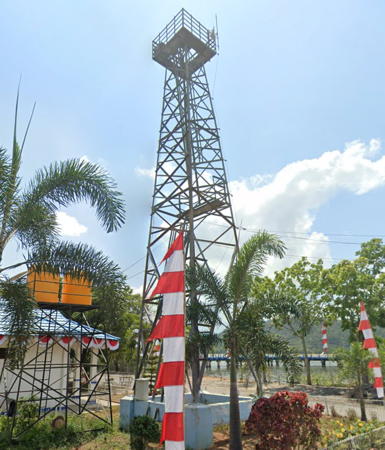
Date unknown. Active; focal plane 22 m (72 ft); white flash every 6 s. 20 m (66 ft) square skeletal tower with gallery, painted white. Google has the 2019 street view seen at right, Apriadi Utama has a photo (tower on the left, behind the tree), and Bing has a satellite view. Batulicin, on the west side of the Laut Strait opposite Kotabaru, is an important ferry port. Located at the base of the ferry pier in Batulicin. Site open, tower closed. Admiralty Q1435; NGA 24973.

Batulicin Light, Tanah Bumbu, August 2019
Google Maps street view
Suwangi
Date unknown. Active; focal plane 28 m (92 ft); white flash every 3.5 s. Approx. 18 m (59 ft) square skeletal tower painted white. No photo available but Google has a satellite view. Suwangi is a forested, uninhabited island in the Laut Strait off Batulicin. Located near the south end of the island. Accessible only by boat. Site status unknown. Admiralty Q1434; NGA 24972.
Gosong Kramat
Date unknown. Active; focal plane 13 m (43 ft); three white flashes every 10 s. 13 m (43 ft) square skeletal tower, painted black with one red horizontal band and mounted on a platform supported by piles. No photo available but Bing has a satellite view. Located ona shoal in the southern end of the Laut Strait. Accessible only by boat. Site status unknown. Admiralty Q1433; NGA 24963.5.
Tanjung Petang ("Evening Cape")
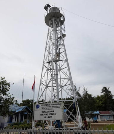
1901. Active; focal plane 19 m (62 ft); white flash every 5 s. 19 m (62 ft) hexagonal cast iron skeletal tower with lantern and gallery, painted white. Several 1-story coast guard buildings. Inni Joa's photo is at right, Mocha Putri has a 2015 photo, Irwanjaya Manaha has a 2021 closeup, Anisa Purwanti has a 2022 photo, and Google has a satellite view of the station. This light is a twin of the Belingkar Hill lighthouse in Kotabaru. Located near Pagatan, on the west side of the southern entrance to the narrow Laut Strait separating Pulau Laut from the mainland of Borneo. Site status unknown. ARLHS IDO-289; DSI-4460; Admiralty Q1432; NGA 24964.
Satui Muara Range Front
Date unknown. Active; focal plane about 17 m (56 ft); green light, pattern unknown. Approx. 17 m (56 ft) square white skeletal tower on a platform supported by piles. Veliq Andika Wicaksono has a photo, a sunset photo of the two range lights is available, and Google has a satellite view. The Admiralty has seven lights listed for Satui Muara but none match the locations of these range towers. Located in the surf just east of the entrance to the Satui estuary. Site open, tower closed. Charted by Navionics but not listed by the Admiralty.
Satui Muara Range Rear
Date unknown. Active; focal plane about 23 m (75 ft); green light, pattern unknown. Approx. 21 m (62 ft) square white skeletal tower. Veliq Andika Wicaksono has a closeup photo, a sunset photo of the two range lights is available and Google has a satellite view. Located onshire about 80 m (260 ft) north of the front light. Site status unknown. Charted by Navionics but not listed by the Admiralty.
Satui
Date unknown. Active; focal plane 18 m (59 ft); white flash every 5 s. 15 m (49 ft) square skeletal tower. Asmar Moh Nasir has a photo and Google has a satellite view. Located at the foot of a coal terminal pier at Satui, near the southwestern corner of Tanah Bumbu Regency. Site status unknown. Admiralty Q1428; NGA 24987.

Tanjung Petang Light, Tanah Bumbu, November 2017
ex-Google Plus photo by Inni Joa

Tanah Laut Regency Lighthouses
Tanah Laut Regency occupies a triangular, sharp-pointed peninsula that is the southernmost land in Kalimantan (Borneo). "Tanah Laut" means "Sea Land."

Muara Kintap (Kintap Estuary) Range Front
Date unknown. Active; focal plane about 15 m (49 ft); light characteristic unknown. Approx. 15 m (49 ft) square white skeletal tower. No photo available but Bing has a satellite view of the two range lights. Located just offshore at the entrance to the Kintap estuary about 65 km (40 mi) northeast of South Cape. Site status unknown. Admiralty Q1423.
Muara Kintap (Kintap Estuary) Range Rear
Date unknown. Active; focal plane about 25 m (82 ft); light characteristic unknown. Approx. 22 m (72 ft) square white skeletal tower. No photo available but Bing has a satellite view of the two range lights. Located about 60 m (200 ft) northwest of the front light. Site status unknown. Admiralty Q1423.1.
Tanjung Selatan (South Cape) (2)
Around 2015 (station established 1905). Active; focal plane 34 m (112 ft); one long white flash every 6 s. 30 m (98 ft) hexagonal cast iron tower with lantern and gallery. Several 1-story coast guard buildings. Lighthouse painted white. Aqmal Noor Zamzam's 2022 photo is at right, Jeryan Friza Ananda has a photo, Fahmie Risdani has a 2020 closeup, and Google has a satellite view of the station. Tanjung Selatan (South Cape) is the southernmost point of Borneo. Located on the point of the cape, about 80 km (50 mi) south of Banjarmasin. Site status unknown. ARLHS IDO-328; DSI-4350; Admiralty Q1422; NGA 24988.
Pulau Datu
Date unknown. Active; focal plane about 13 m (43 ft); white light, pattern unknown. Approx. 13 m (43 ft) square skeletal tower mounted on a platform supported by piles. A drone view is available, Farina Amelia has a distant view (tower at far left), and Bing has a satellite view. Located at the west end of an island off a cape about 10 km (6 mi) north of Tanjung Selatan. Accessible only by boat. Site open, tower closed. Admiralty Q1421.
Tekisung (Batu Layang Layang)
Date unknown. Active; focal plane 19 m (62 ft); yellow flash every 3 s. 19 m (62 ft) square skeletal tower on a platform supported by piles, painted yellow. Risna Indriani has a very distant 2022 sunset view from shore and Google has a 2023 street view from shore but only an indistinct satellite view. Located off the Tekisung beach about 50 km (30 mi) north of Tanjung Selatan. Accessible only by boat but probably visible from shore. Site open, tower closed. Admiralty Q1420; NGA 24989.
Sungai Barito Outer
Date unknown (lightship station established 1901). Inactive since 2013. Approx. 20 m (66 ft) square skeletal tower adjacent to a building (possibly a pilot station) mounted on a pier supported by piles. No photo avalable and the tower is not seen in Google's distant satellite view of the area. The lighthouse was replaced by a buoy (NGA 24992). Located about 18 km (11 mi) southwest of the mouth of the Barito River. Accessible only by boat. Site open, tower closed. ex-Admiralty K1413.1; ex-NGA 24996.

Tanjung Selatan Light, Tanah Laut, March 2022
Google Maps photo by Aqmal Noor Zamzam

Southern Barito Kuala Regency Lighthouses
These are lights guiding vessels on the Barito River to Banjarmasin, the former capital of South Kalimantan Province. Banjarmasin is a large city with a population of more than 650,000.
Sungai Barito (Range Front?)
Date unknown. Removed in 2014-15; listed with focal plane 25 m (82 ft); white light, 1 s on, 1 s off. 25 m (82 ft) square skeletal tower painted with black and white horizontal bands and mounted on a platform supported by piles. No photo available but Bing has a satellite view. Apparently this was an approach range for the Barito River, which leads to the provincial capital Banjarmasin. The Admiralty and NGA list the lights as a range, but Navionics does not chart them as a range and they do not align with the current entrance channel. We don't know if new, smaller range lights were installed. Located south of the mouth of the river. Accessible only by boat. Site open, tower closed. Admiralty Q1413.7; NGA 25000.
Sungai Barito (Range Rear?)
Date unknown. Removed in 2014-15; listed with focal plane 40 m (131 ft); white light, 2 s on, 2 s off. 40 m (131 ft) square skeletal tower painted with black and white horizontal bands and mounted on a platform supported by piles. No photo available but Bing has a satellite view. Located in the mouth of the Barito River 1.7 km (1 mi) north northeast of the front light. Accessible only by boat. Site open, tower closed. Admiralty Q1413.71; NGA 25004.
Tanjung Pedata Tua
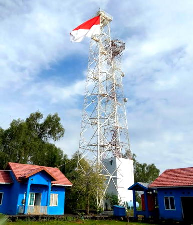
Date unknown. Active; focal plane about 42 m (138 ft); white light, pattern unknown. 40 m (131 ft) square white skeletal tower with lantern and gallery. A 2018 photo is at right, Abdu Rahman also has a photo, a 2021 drone view is available, and Google has a satellite view. Located about 1.6 km (1 mi) west of the mouth of the Barito River. Site status unknown. DSI-4405; Admiralty Q1413.4.
Tanjung Telan (2)
Date unknown. Active; focal plane about 20 m (66 ft); red flash every 5 s. Approx. 20 m (66 ft) square white skeletal tower on a platform supported by piles. No photo available but Google has a satellite view. NGA lists a red tower only 7 m (23 ft) tall. Located just off the west bank of the river about 5 km (3 mi) from the mouth. Accessible only by boat. Site open, tower closed. Admiralty Q1416; NGA 25012.
Pulau Paget North
Date unknown. Active; focal plane about 9 m (30 ft); green light, pattern unknown. Approx. 9 m (30 ft) green skeletal tower on a platform supported by piles. No photo available but Google has a satellite view. Located off the northern tip of Pulau Paget, a forested island in the Barito River. Accessible only by boat. Site open, tower closed. Admiralty Q1417.5.

Banjarmasin City Lighthouses
Pelabuhan Mantuil
Date unknown. Active; focal plane about 22 m (72 ft); white light, pattern unknown. Approx. 20 m (66 ft) square white skeletal tower. Ahmad Muhlisun has a 2020 photo, Heri Bahrani has a view from the river, and Google has a street view and a satellite view. Located at a Indonesian Coast Guard base on the east bank of the Barito River about 5 km (3 mi) south of downtown Banjarmasin. Site status unknown. Admiralty Q1418.4.

Tanjung Pedata Tua Light, Banjar, September 2021
Google Maps photo by Danydan Dany
Laem Bromo
Date unknown. Active; focal plane about 15 m (49 ft); red light, pattern unknown. Approx. 15 m (49 ft) square red skeletal tower. No photo available but Google has a satellite view. Located on the left (north) side of the entrance to the Martapura River and harbor just north of Pelabuhan Mantuil. Site status unknown. Admiralty Q1418.45.
Trisakti Harbour
Date unknown. Active; focal plane 40 m (131 ft); white flash every 3 s. 36 m (118 ft) square white skeletal communications tower. Umi Pujiono has a view from the river and Google has a 2015 street view and a satellite view. Located in the Trisakti harbor complex in southern Banjarmasin. Site status unknown. Admiralty Q1418.48.
Pelabuhan Feri Banjar Raya
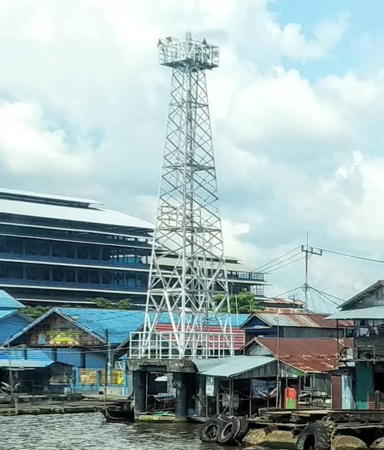
Date unknown. Active; focal plane 15 m (49 ft); white flash every 3.5 s. 15 m (49 ft) square white skeletal tower on a platform supported by piles. Irun Qybit has the photo at right and Google has a street view and a satellite view. Oddly, the Admiralty lists this light as "Pulau Kembang West" although it is east of that island and across the river. Located on the waterfront in downtown Banjarmasin. Admiralty Q1419; NGA 25018.
Pulau Kembang South
Date unknown. Active; focal plane about 18 m (59 ft); red light, pattern unknown. Approx. 18 m (59 ft) red skeletal tower on a platform supported by piles. Google has a distant 2023 street view and a satellite view. Located off the southern tip of Pulau Kembang, an island off the waterfront of Banjarmasin. Accessible only by boat. Site open, tower closed. Admiralty Q1419.002.
 
DML Dockyard
Date unknown. Active; focal plane 16 m (52 ft); white flash every 10 s. 15 m (49 ft) square white skeletal tower. No photo available but Google has a satellite view. Located in the DML Dockyard on the Banjarmasin waterfront. Site and tower closed. Admiralty Q1419.001.
Pulau Kembang North
Date unknown. Active; focal plane about 16 m (52 ft); red light, pattern unknown. Approx. 16 m (52 ft) red skeletal tower on a platform supported by piles. No photo available but Google has a satellite view. Located off the northern tip of Pulau Kembang. Accessible only by boat. Site open, tower closed. Admiralty Q1419.004.
Pulau Alalak
Date unknown. Active; focal plane about 15 m (49 ft); green light, pattern unknown. Approx. 15 m (49 ft) green skeletal tower on a platform supported by piles. Google has a street view and a satellite view. Located at a port on the northwestern tip of Pulau Alalak, an island on the east side of the river on the north side of Banjarmasin. Site open, tower closed. Admiralty Q1419.006.

Pelabuhan Feri Banjar Raya Light, Banjarmasin, March 2020
Google Maps photo by Irun Qybit

Northern Barito Kuala Regency Lighthouses
Ujung Panti
Date unknown. Active; focal plane about 15 m (49 ft); red light, pattern unknown. Approx. 15 m (49 ft) skeletal tower on a platform supported by piles. Google has a satellite view and a distant street view. Located just off the west bank of the Barito River at a sharp bend about 8 km (5 mi) north of Banjarmasin. Accessible only by boat. Site open, tower closed. Admiralty Q1419.007.
Pulau Bakut
Date unknown. Active; focal plane about 15 m (49 ft); red light, pattern unknown. Approx. 15 m (49 ft) skeletal tower on a platform supported by piles. No photo available but Google has a satellite view. Located at the southern tip of Pulau Bakut, an island in the river crossed by the Barito Bridge. Accessible only by boat. Site open, tower closed. Admiralty Q1419.06.
Balandean
Date unknown. Active; focal plane about 13 m (43 ft); green light, pattern unknown. Approx. 13 m (43 ft) square cylindrical green skeletal tower on a platform supported by piles. No photo available but Google has a satellite view. Located on the east side of the Barito River about 5 km (3 mi) north of the Barito Bridge. Accessible only by boat. Site open, tower closed. Admiralty Q1419.08.

Information available on lost lighthouses:

Notable faux lighthouses:

Adjoining pages: North: Eastern Kalimantan | East: South Sulawesi | West: Central Kalimantan

Return to the Lighthouse Directory index | Ratings key

Posted December 9, 2008. Checked and revised May 21, 2024. Lighthouses: 51. Site copyright 2024 Russ Rowlett and the University of North Carolina at Chapel Hill.