Lighthouses of Indonesia: Southern Maluku (Moluccas)

The Republic of Indonesia has been independent since 1945, after having been the Dutch East Indies for more than 350 years. It is a huge country, stretching along both sides of the Equator for more than 46 degrees of longitude (roughly 5100 km or 3200 miles). Comprised of some 17,000 islands (more than 6000 inhabited islands), it has hundreds of major aids to navigation.

Indonesia is divided into 38 provinces (provinsi) and the provinces are subdivided into county units called regencies (kabupaten). Maluku Province includes the central and southern islands of Maluku (the Moluccas), the islands traditionally known in the West as the "Spice Islands." Broadly speaking, the Moluccas lie east of Sulawesi (Celebes), south of the Philippines, and west of New Guinea. This page includes the lighthouses of southern Maluku Province in the Southwest Maluku and Tanimbar Islands Regencies.The islands covered by this page lie at the extreme eastern end of the Lesser Sunda Islands, separating the Banda Sea to the northwest from the Arafura Sea to the southeast.

More than 700 languages are spoken in Indonesia. The official national language, Indonesian (Bahasa Indonesia), was standardized from a form of Malay that served as a lingua franca across the archipelago. In Indonesian a lighthouse is a mercusuar or a menara suar. Tanjung is a cape, ujung is a headland or point of land, bukit is a hill, sungai is a river, kuala or muara is an estuary or river mouth, pulau is an island, karang is a reef, batu is a rock, laut is a sea, selat is a strait, teluk is a bay, pelabuhan is a harbor, and labuhan is a port. It's also worth knowing that the word for an island is nusa in Balinese and gili in the Sasak language spoken on Lombok and in western Sumbawa.

Aids to navigation in Indonesia are operated and maintained by the Directorate of Marine Navigation within the Directorate General of Sea Transportation

ARLHS numbers are from the ARLHS World List of Lights. Admiralty numbers are from volume Q of the Admiralty List of Lights & Fog Signals. U.S. NGA List numbers are from Publication 112.

General Sources
World of Lighthouses - Indonesia
Photos by various photographers available from Lightphotos.net.
Online List of Lights - Indonesia
Photos by various photographers posted by Alexander Trabas. Photos from the Saumlaki area were contributed by Bjørn Poulsen.
Navionics Charts
Navigation chart for Indonesia.
 
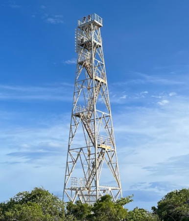
Pulau Lakor Light
Pulau Lakor Light, Letti Islands, November 2012
ex-Panoramio photo copyright Darell Tristan Utanmeru
used by permission

Maluku Barat Daya (Southwest Maluku) Regency Lighthouses

These islands lie north and east of Timor at the eastern extension of the Lesser Sunda Islands. The districts are formally grouped into three archipelagoes: the Terselatan Group (including the large island of Wetar and the smaller islands from Liran to Romang), the Lemola Group (Letti, Moa and Lakor), and the Babar Group (including the Damer and Sermata Islands). Geographically are two chains of islands, a northern chain extending east and northest from Alor and a southern chain extending from the east end of Timor.

Terselatan Group: Liran and Wetar Lighthouses
Wetar is by far the largest island of the Southwest Maluku Regency, 120 km (75 mi) long west to east and up to 43 km (27 mi) wide. It is due north of Timor, separated from that larger island by the Wetar Strait, 50 km (30 mi) wide at its narrowest point. The island is thinly populated with about 8000 residents.
Pulau Liran (Wetar Strait) (2)
2010 (?) (station established 1903). Active; focal plane 85 m (279 ft); four white flashes every 40 s. 40 m (131 ft) square skeletal tower with lantern and gallery, painted white. Half a dozen coast guard station buildings. The lighthouse is near the left edge of Bjørn Grøtting's aerial photo and Google has a satellite view of the station. The original lighthouse was a hexagonal skeletal tower with lantern and gallery; the Amsterdam Tropenmuseum has a 1939 photo. This lighthouse is important in guiding ships toward the island of Timor. Located at the southern tip of Liran, a small island off the southwestern tip of the much larger island of Wetar, about 75 km (45 mi) north northeast of Dili, Timor Leste. Site status unknown. ARLHS IDO-357; Admiralty Q1372; NGA 25716.
* Pelabuhan Pulau Liran
2020 (?). Active; focal plane about 25 m (82 ft); white light, pattern unknown. Approx. 22 m (72 ft) concrete tower with lantern and gallery. Stanly Arlan has a 2022 view from the sea, Tri H. Kuswoyo has a very distant 2020 view from the sea, and Google has a satellite view. The lighthouse is not seen in an August 2018 photo of the port. Located at the foot of the pier at the Pulau Liran port, on the east side of the island. Site open, tower closed. Admiralty Q1372.2.
Tanjung Tutunhatoloi (Tutun Hatoloi)
2004. Active; focal plane 90 m (295 ft); white flash every 7 s. 30 m (98 ft) square skeletal tower with gallery, painted white. No photo available but Google has a satellite view. Located at the northeastern corner of Wetar. Site status unknown. Admiralty Q1372.5; NGA 25716.6.
Tanjung Tutuneden (Tutun Eden, Wetar)
2007. Active; focal plane 45 m (148 ft); two white flashes every 10 s. 40 m (131 ft) square skeletal tower with lantern and gallery, painted white and rising from a 2-story station building. Alce N. Sudarmanto's photo is at right, a 2020 photo is available, and Google has a satellite view. Located on a prominent cape on the south coast of Pulau Wetar. Site status unknown. Admiralty Q1372.3; NGA 25716.3.
* Ilwaki (Pelabuhan Penyeberangan)
2009. Active; focal plane about 16 m (52 ft); white light, pattern unknown. Approx. 12 m (39 ft) square skeletal tower. Paulus Abraham Monny has a 2020 photo and Google has a satellite view. Located at the ferry terminal in Ilwaki, a small community on the central south coast of Wetar. Site open, tower closed. Not listed by the Admiralty.

Tanjung Tutuneden Light, Wetar, February 2018
ex-Google Plus photo by Alce N. Sudarmanto
Pulau Gunung Api
Date unknown. Active; focal plane 15 m (49 ft); white flash every 6 s. Listed only as a "white beacon" but probably a white skeletal tower. No photo available; the tower is probably just visible to the left in Lodelle Marcelino's distant sea view of the island. The light has not been found in Bing's satellite view of the island. Gunung api ("mountain fire") is the Indonesian word for a volcano, and the island is easily confused with several other "Volcano Islands" in eastern Indonesia. This volcano island is about 58 km (35 mi) north of Wetar. Located on the west side of the island. Accessible only by boat. Site status unknown. Admiralty Q1372.4; NGA 25716.5.

Terselatan Group: Kisar and Romang Lighthouses
Tanjung Tutunmahin (Oirata, Pulau Kisar)
2004. Active; focal plane 90 m (295 ft); white flash every 4.5 s. 30 m (98 ft) square skeletal tower with gallery, painted white. No photo available but Google has a satellite view. Located atop a steep bluff at the southeastern tip of Kisar, an island about 30 km (19 mi) north of the eastern tip of Timor. Accessible only by boat. Site status unknown. Admiralty Q1373.2.
* Wonreli (Pelabuhan Wonreli) (2)
Around 2019. Active; focal plane about 15 m (49 ft); white flash every 3 s. Approx. 12 m (39 ft) square skeletal tower. Entire lighthouse is white. Paulus Abraham Monny has the 2020 photo seen at right, John Robert Rumatora has a drone view, the light is in the background of Ivan Jepe's photo of the ferry terminal and Google has a satellite view. This light replaced a round post with two galleries seen in what must be an older photo by Jepe. Located at Wonreli on the west coast of Kisar. Site open, tower closed. Admiralty Q1373; NGA 25718.
Pulau Nyata
Date unknown. Active; focal plane 35 m (115 ft); three white flashes every 15 s. Approx. 30 m (98 ft) square skeletal tower with gallery, painted white. No photo available but Google has a satellite view. Located on Pulau Nyata, off the west side of the larger Pulau Romang, about 50 km (30 mi) east northeast of Pulau Wetar. Accessible only by boat. Site status unknown. Admiralty Q1373.5; NGA 25718.5.
* Pelabuhan Hila (Pulau Romang)
Date unknown. Active; focal plane about 22 m (72 ft); white light, pattern unknown. Approx. 20 m (66 ft) square white skeletal tower. Daru Ari Widodo has a 2017 photo, Paulus Abraham Monny has a distant 2020 view, and Google has an indistinct satellite view. Located at the ferry terminal at Hila on the west coast of Pulau Romang. Site open, tower closed. Admiralty Q1373.9.

Pelabuhan Wonreli Light, Kisar April 2013
Google Maps photo by Paulus Abraham Monny

Lemola Group: Letti, Moa, and Lakor Lighthouses
The Letti Islands are the three closely spaced islands of Letti, Moa, and Lakor off the eastern tip of Timor. "Lemola" is an acronym combining the first two letters of the names of the three islands. The islands have a total population of nearly 17,000.
Tanjung Tutpateh (Pulau Letti)
Date unknown. Active; focal plane 42 m (138 ft); three white flashes every 10 s. 40 m (131 ft) square skeletal tower with lantern and gallery, painted white. Two coast guard station buildings. No photo available but Google has a satellite view of the station. This light and the former Pulau Yako Light in Timor Leste framed a narrow passage around the eastern end of Timor, joining the Banda Sea to the Timor Sea. Located at the western tip of Pulau Leti, westernmost of the three Letti Islands, 35 km (22 mi) east northeast of Pulau Yako. Site status unknown. ARLHS IDO-335; Admiralty Q1374; NGA 25719.
* Serwaru (Pelabuhan Letti)
Date unknown. Active; focal plane 23 m (75 ft); two white flashes every 7 s. 20 m (66 ft) square pyramidal skeletal tower painted white. Kaka Bakker has a distant 2018 view, Paulus Abraham Monny also has a distant view, and Google has an indistinct satellite view. Located at the base of the ferry pier at Serwaru, on the north coast of Pulau Letti. Site open, tower closed. Admiralty Q1374.3.
* Kaiwatu (Pulau Moa)
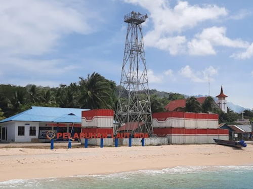
Date unknown. Active; focal plane 23 m (75 ft); two white flashes every 10 s. 20 m (66 ft) square pyramidal skeletal tower painted white. Erfin Effendhi's photo is at right, Danang Sucahyo has a photo, and Google has a satellite view. Located on the waterfront at Kaiwatu, near the northwestern end of Pulau Moa, the largest of the Letti Islands. Site open, tower closed. Not listed by the Admiralty.
* Warwawang (Pulau Lakor)
Date unknown. Active; focal plane 23 m (75 ft); white flash every 6 s. 20 m (66 ft) square pyramidal skeletal tower painted white. Sabiqun Nahar has a distant view and Google has a satellite view. Located at the ferry terminal at Warwawang on the north coast of Pulau Lakor, the easternmost of the Letti Islands. Site open, tower closed. Admiralty Q1374.8.

Pelabuhan Moa Light, Kaiwatu, September 2021
Google Maps photo by Erfin Effendhi
Pulau Lakor
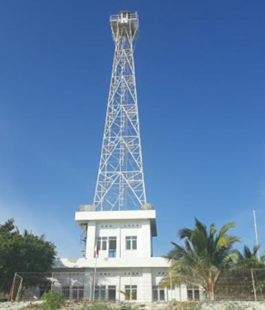
2007. Active; focal plane 35 m (115 ft); two white flashes every 10 s. 30 m (98 ft) square skeletal tower with gallery, painted white, mounted on a square 1-story equipment building. Darell Tristan Utanmeru's photo is at the top of this page and Google has a satellite view. Pulau Lakor is the easternmost of the three major islands of the Letti group. Located at Keti, a village on the south side of the island. Accessible only by boat. Site open, tower closed. Admiralty Q1375.
 

Babar Group: Sermata Islands Lighthouses
Meatimiarang (Meatiy Miarang, Brisbane Island) (2)
Date unknown (station established 1903). Active; focal plane 25 m (82 ft); three white flashes every 29 s. 23 m (75 ft) hexagonal skeletal tower with lantern and gallery, painted white. Numerous coast guard station buildings. The photo at right is from a video posted by Maluku Province, Safiul Huda has a distant 2023 view, and Google has a satellite view of the station. The lighthouse marks an extensive and dangerous reef system midway between Pulau Lakor, in the Leti group, and Pulau Sermata, the largest island of the Sermata group. Located on a small island at the south end of the reef. Accessible only by boat. Site status unknown. ARLHS IDO-166; Admiralty Q1376; NGA 25720.
* Mahaleta (Pulau Sermata)
Date unknown. Active; focal plane about 23 m (75 ft); white light, pattern unknown. Approx. 20 m (66 ft) square white skeletal tower. Febriano Noya has a 2022 photo and Google has a satellite view. Located at the ferry terminal at Mahaleta, on the north coast of Pulau Sermata. Site open, tower closed. Not listed by the Admiralty.
 

Meatimiarang Light, Pulau Meatimiarang, September 2023
video frame (0:13) by Maluku Province

Babar Group: Damar Islands Lighthouse
Pulau Damar
Date unknown. Active; focal plane about 22 m (72 ft); white light, pattern unknown. Approx. 20 m (66 ft) square white skeletal tower. Jangkar Miring has a 2022 photo, Paulus Abraham Monny has a 2020 photo, Muhammad Akbar has a 2018 view from the sea; Bing's satellite view shows the pier but not the lighthouse. Damar is a volcanic island about 20 km (13 mi) in diameter and largest of the Damar Islands, located in the Banda Sea northwest of Babar. The island's volcano, Mount Wurlali, is active and has forced evacuations in the past. Located at the port on the east side of the island. Site status unknown. Admiralty Q1376.05.

Babar Group: Babar Islands Lighthouses
Babar is by far the largest of the Babar Islands, located in the far east of the Sunda arc halfway between the Letti and Tanimbar islands. Babar is about 32 km (20 mi) in diameter. The islands have a total population of about 18,000.
* Tepa
Date unknown. Active; focal plane 23 m (75 ft); white flash every 5 s. 20 m (66 ft) square white skeletal tower. The tower is seen near the left edge of Lisa Kamanasa's 2022 photo and Google has a satellite view. Located at the ferry terminal at Tepa, on the west side of Pulau Babar. Site open, tower closed. Admiralty Q1376.1.
* Kroing
Date unknown. Active; focal plane 23 m (75 ft); white flash every 10 s. 20 m (66 ft) square white skeletal tower. Melkias Killay has a distant 2021 view and the shadow of the lighthouse is seen in Google's satellite view. The Admiralty lists the lighthouse as Kroing Letwurung; Letwurung is the name of an adjoining village. Located on the waterfront at Kroing, on the east side of Pulau Babar. Site open, tower closed. Admiralty Q1376.2.
* Papilewan (Pulau Masela)
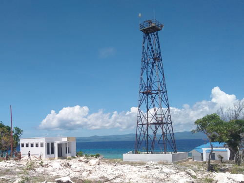
Date unknown. Active; focal plane 23 m (75 ft); two white flashes every 7.5 s. 20 m (66 ft) square pyramidal skeletal tower painted white. Yudha Robi Hamsah's photo is at right, Janter Jlok has a 2017 photo, the lower half of the tower is seen in another December 2016 photo (halfway down the page), and Google has an indistinct satellite view. Pulau Masela is a small island on the south side of the Babar group. Located at the ferry terminal at Papilewan on the north side of Pulau Masela. Site open, tower closed. Admiralty Q1376.25.
Pulau Masela
2007. Active; focal plane 43 m (141 ft); two white flashes every 12 s. 40 m (131 ft) square skeletal tower with lantern and gallery rising from a 2-story coast guard station building. No photo available but Google has a satellite view of the station. Located at the southern end of the island. Site status unknown. Admiralty Q1376.3.
Dawelor
Date unknown. Active; focal plane about 23 m (75 ft); white light, pattern unknown. 20 m (66 ft) square white skeletal tower. Eko Listiono has a 2020 photo and Bing has a satellite view. Located at the west end of Pulau Dawelor, a small island about 30 km (19 mi) northeast of Pulau Babar. Site open, tower closed. Not listed by the Admiralty.

Papilewan Light, Pulau Masela, December 2016
Wikimedia Creative Commons photo by Yudha Robi Hamsah

Kepulauan Tanimbar (Tanimbar Islands) Regency Lighthouses

The Tanimbar Islands are roughly halfway between Timor and Papua (New Guinea). There are some 65 islands in the group, tightly clustered around the large island of Yamdena. The population of the islands is about 125,000.

Selaru Lighthouses
Pulau Selaru is the southwesternmost of the Tanimbar Islands, located southwest of Pulau Yamdena. The island is about 80 km (50 mi) long and 2-15 km (1.25-9 mi) wide. Adaut is the principal town on the island.
Pulau Batarkusu (2)
Date unknown. Active; focal plane about 45 m (148 ft); white flash every 4 s. Approx. 30 m (98 ft) white skeletal tower with lantern and gallery mounted on a square 1-story equipment building. Trabas has Poulsen's view from the sea and Google has an indistinct satellite view. NGA lists a 10 m (33 ft) white skeletal tower with a focal plane of 14 m (46 ft). Located at the southeastern tip of Selaru. Site status unknown. Admiralty Q1378; NGA 25722.
Tanjung Arousu (Orousu)
2006. Active; focal plane 37 m (121 ft); white flash every 10 s. 30 m (98 ft) octagonal white concrete tower with lantern and gallery. Candra Lisnawan's photo is at right, Iweng Candy has a 2021 closeup, Mathias Rony also has a 2021 photo, Jurnal Maritim has a photo on Twitter, and Google has a satellite view. Located at the southern tip of the island. Site status unknown. Admiralty Q1376.5; NGA 25721.
* Adaut
Date unknown. Active; focal plane 23 m (75 ft); white flash every 4 s. 20 m (66 ft) square pyramidal skeletal tower painted white. Agustinus Songupnuan has a photo and Bing has an indistinct satellite view. Located on the waterfront at Adaut, on the north coast of Pulau Selaru. Site open, tower closed. Admiralty Q1378.8.
Pulau Selaru East
2007. Active; focal plane 45 m (148 ft); two white flashes every 10 s. 40 m (131 ft) square skeletal tower with lantern and gallery, mounted atop a coast guard station building. No photo available but Google has a satellite view of the station. This station is very similar to the Pulau Masela station. Located near the northeastern end of Pulau Selaru, facing the Arafura Sea. Site status unknown. Admiralty Q1378.5.

Yamdena Lighthouses
Yamdena is by far the largest island of the Tanimbar Islands. The island is about 150 km (95 mi) long and up to 40 km (25 mi) wide. Saumlaki, at the southern end of the island, is the principal town.

Meyundas (Pulau Yamdena)
2007. Active; focal plane 45 m (148 ft); two white flashes every 10 s. 40 m (131 ft) square skeletal tower with lantern and gallery, painted white, mounted on a 2-story coast guard building. No photo available but Google has a satellite view of the station. Located in Meyundas, a town on the east coast of Pulau Yamdena. Site status unknown. Admiralty Q1379.5.

Tanjung Arousu Light, Pulau Selaru, Tanimbar Islands
photo copyright Candra Lisnawan; used by permission
Pulau Asutubun (Asoeboetoen) (2?)
Date unknown. Active; focal plane 17 m (56 ft); white flash every 3 s. 15 m (49 ft) skeletal tower, painted white. Trabas has Poulsen's very distant view from the sea and the tower is seen poking above the trees in Bing's fuzzy satellite view. Located off the west side of Pulau Asutubun, an island off the southern tip of the much larger Pulau Yamdena, marking the entrance to Teluk Dalam (Dalam Bay) and Saumlaki. Site status unknown. Admiralty Q1379; NGA 25724.
Saumlaki Pertamina Depot
Date unknown. Active; focal plane 11 m (36 ft); four quick white flashes every 8 s. 10 m (33 ft) square skeletal tower with partially enclosed upper portion, painted white. Trabas has Poulsen's closeup photo and Bing has an indistinct satellite view. Located at the Pertamina Oil Terminal on the south side of Saumlaki. Site and tower closed. Admiralty Q1380.3; NGA 25728.
Saumlaki Southwest (Teluk Dalam)
Date unknown. Active; focal plane 14 m (46 ft); green flash every 5 s. 14 m (46 ft) round barbell-shaped green tower mounted on a platform supported by piles. Trabas has Poulsen's closeup photo and Google has a satellite view. Located about 300 m (330 yd) off the main quay at Saumlaki. Accessible only by boat but visible from shore. Site open, tower closed. Admiralty Q1380.2; NGA 25734.
* Saumlaki
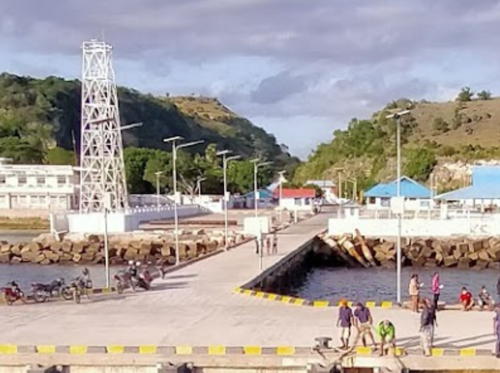
Date unknown. Active; focal plane 33 m (108 ft); two white flashes every 15 s. Approx. 27 m (89 ft) square skeletal tower, painted white. Rusdy Alhafizh's photo is at right, Trabas has Poulsen's photo, E.D. Pantouw has a photo, Rusdin Jumurdin has a distant street view and Google has an indistinct satellite view. NGA lists a much shorter tower for this station, but this may be the result of confusion with the pier light (next entry). Located on the waterfront of Saumlaki, the regency capital and principal town of Tanimbar, near the southeastern corner of Pulau Yamdena. Site open, tower closed. Admiralty Q1380; NGA 25732.
* Saumlaki Pier
Date unknown. Active; focal plane about 12 m (39 ft); white light, characteristic unknown. Approx. 8 m (26 ft) square skeletal tower painted white. Rusdin Jumurdin has a closeup street view, Agunawan Opa has a drone view of the pier, and Google has an indistinct satellite view. Located on the ferry pier at Saumlaki. Site open, tower closed. Possibly Admiralty Q1380.22.
* Pelabuhan Seira
Date unknown. Active; focal plane about 20 m (66 ft); white light, pattern unknown. Approx. 17 m (56 ft) square white skeletal tower. Kaki Panjang has a photo of the base of the tower and Google has a satellite view. Located at the base of the pier in Wer Maktian, the principal town of Pulau Seira, an island just off te southwest coast of Yamdena. Site open, tower closed. Not listed by the Admiralty.

Saumlaki Light, Pulau Yamdena, August 2020
Google Maps photo by Rusdy Alhafizh

Larat and Fordate Lighthouses
Larat is a boomerang-shaped island separated from the north end of Yamdena by a narrow strait. Fordate is a short distance north of Larat, separated by another narrow strait.
Pulau Larat Southeast
2007. Active; focal plane 45 m (148 ft); two white flashes every 10 s. 40 m (131 ft) skeletal tower with lantern and gallery, painted white and mounted atop a 2-story coast guard building. No photo available but Google has a satellite view of the station. Located on the southeastern coast of Pulau Larat. Site status unknown. Admiralty Q1383.5.
* Ritabel (Pelabuhan Larat) (3?)
Date unknown. Active; focal plane about 22 m (72 ft); white flash every 3 s. Approx. 20 m (66 ft) square white skeletal tower mounted on a square 1-story equipment building. The lighthouse is at the upper left corner in a 2017 photo of the waterfront and at the right edge of Misbach Hilmy' 2020 photo; Google has a satellite view. An older photo (no longer online) showed a fiberglass tower and NGA describes a 9 m (30 ft) skeletal tower. Ritabel is a port at the west end of Pulau Larat, facing the narrow strait that separates that island from Yamdena. Located on the waterfront of Ritabel. Site open, tower closed. Admiralty Q1382; NGA 25736.
* Sofyanin
2019 (?). Active; focal plane about 22 m (72 ft); white light, pattern unknown. . Approx. 20 m (66 ft) square white skeletal tower mounted on a square concrete platform. Nikodemus Rahanratu has a February 2020 photo and Emanuel Niswotar has the 2021 photo at right, but the lighthouse may be too new to appear in Google's satellite view. Located on the beach at Sofyanin, a village on the west side of Pulau Fordate, an island off the north side of Pulau Larat. Site open, tower closed. Not listed by the Admiralty.
Tanjung Warlangir (Pulau Fordate)
2003. Active; focal plane 74 m (243 ft); white flash every 6 s. 40 m (131 ft) skeletal tower, painted white. Several coast guard station buildings. No photo available but Google has a satellite view showing the station. Located on the northern end of Pulau Fordate, the extreme northeastern end of the Tanimbar group. Site status unknown. Admiralty Q1384; NGA 25741.

Sofyanin Light, Pulau Fordate, July 2021
Google Maps photo by Emanuel Niswotar

Molu Lighthouses
Adodo (Pulau Molu) (?)
Date unknown. Possibly destroyed; listed with focal plane 23 m (75 ft); white flash every 4 s. 20 m (66 ft) square pyramidal skeletal tower painted white. No photo available and the lighthouse is not seen in Google's satellite view of the port or of the listed location to the north. This light was announced in an Australian notice to mariners in 2015. In 2018 there was a report of storm damage to port facilities. Should be located somewhere near the ferry pier at Adodo (Welangkau), on the west coast of Pulau Molu, the northernmost of the principal Tanimbar Islands. Site open, tower closed. Admiralty Q1390.
Pulau Kalbur
2003. Active; focal plane 60 m (197 ft); white flash every 4 s. 40 m (131 ft) skeletal tower, painted white. Several coast guard station buildings. No photo available but Google has a satellite view of the station. Located on an island off the northern tip of Pulau Molu, at the northern end of the Tanimbar group. Site status unknown. Admiralty Q1384.5; NGA 25741.2.

Information available on lost lighthouses:

Notable faux lighthouses:

Adjoining pages: North: Central Maluku | Northeast: Southeastern Maluku | South: Timor Leste | Southwest: Northeastern Sundas

Return to the Lighthouse Directory index | Ratings key

Posted December 31, 2008. Checked and revised October 21, 2023. Lighthouses: 40. Site copyright 2023 Russ Rowlett and the University of North Carolina at Chapel Hill.