Lighthouses of Indonesia: Southern Papua

The Republic of Indonesia has been independent since 1945 after having been the Dutch East Indies for more than 350 years. It is a huge country, stretching along both sides of the Equator for more than 46 degrees of longitude (roughly 5100 km or 3200 miles). Comprised of some 17,000 islands (more than 6000 inhabited islands), it has hundreds of major aids to navigation.

Indonesia is divided into 38 provinces (provinsi) and the provinces are subdivided into county units called regencies (kabupaten). The lighthouses on this page are in Indonesian Papua (western New Guinea). In 1828 the Dutch extended their claim to the western half of New Guinea, the world's second-largest island, but they established no major settlements until nearly 1900. When Indonesia became independent in 1949 Papua was excluded and remained under Dutch control. Following strong Indonesian effrots to claim control an agreement in 1962 provided for a transitional period under United Nations administration. In 1969 an asembly of elder leaders decided to join Indonesia. However an independence movement called the Free Papua Movement (OPM) continues and a varying degree of unrest has persisted to the preent day.

This page includes the lighthouses of the south coast of Indonesian Papua in the provinces of South Papua and Central Papua. These provinces were carved out of Papua Province in 2022. Central Papua also has a north coast, and lighthouses of that coast are described on the Northern Papua page.

More than 700 languages are spoken in Indonesia. The official national language, Indonesian (Bahasa Indonesia), was standardized from a form of Malay that served as a lingua franca across the archipelago. In Indonesian a lighthouse is a mercusuar or a menara suar. Tanjung is a cape, ujung is a headland or point of land, bukit is a hill, sungai is a river, kuala or muara is an estuary or river mouth, pulau is an island, karang is a reef, batu is a rock, laut is a sea, selat is a strait, teluk is a bay, pelabuhan is a harbor, and labuhan is a port. It's also worth knowing that the word for an island is nusa in Balinese and gili in the Sasak language spoken on Lombok and in western Sumbawa.

Aids to navigation in Indonesia are operated and maintained by the Directorate of Marine Navigation within the Directorate General of Sea Transportation

ARLHS numbers are from the ARLHS World List of Lights. Admiralty numbers are from volume Q of the Admiralty List of Lights & Fog Signals. U.S. NGA List numbers are from Publications 111 and 112.

General Sources
World of Lighthouses - Indonesia
Photos by various photographers available from Lightphotos.net.
Online List of Lights - Indonesia - Papua
Photos by various photographers posted by Alexander Trabas.
Navionics Charts
Navigation chart for Papua.

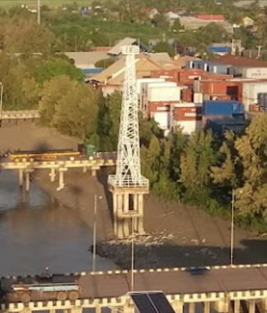
Tanjung Mimiabe Light, Merauke, November 2008
ex-Panoramio photo copyright T. Palgunadi; used by permission

South Papua Province: Merauke Regency Lighthouses

Papua New Guinea Border Lighthouses
In southern New Guinea an 1895 treaty between the Netherlands and Great Britain established the meridian line of longitude 141° 01' 10" East as the boundary between Dutch Papua, now Indonesian Papua, and Britain's Papua colony, now part of the independent nation of Papua New Guinea.
Sungai Torasi (Torasi River) Border (2 lights?)
Date unknown. Active; focal plane 14 m (46 ft); white flash every 3 s. 14 m (46 ft) square skeletal tower with gallery, painted white and mounted on a platform supported by piles. No closeup photo available but Didik Heriyanto's 2018 drone view shows two lights at the right edge. Bing's satellite view shows both lights but Google's satellite view shows only the outer light; it's possible the inner light has been removed. This light marks the maritime boundary between Indonesia and Papua New Guinea. Located just off the east side of the mouth of the Torasi River, marking the Papua New Guinea border. Accessible only by boat. Site open, tower closed. Admiralty Q3336; NGA 25887.
[Sungai Torasi (Torasi River) Entrance]
Date unknown. Active; focal plane about 15 m (49 ft); green light, pattern unknown. Approx. 15 m (49 ft) post atop a platform supported by piles. No closeup photo available but Didik Heriyanto's drone view shows this light on the east (right) side of the river entrance and Google has a satellite view. Located about 300 m (0.2 mi) west of the border lighthouse. Accessible only by boat. Site open, tower closed. Not listed by the Admiralty.
Sungai Torasi (Torasi River)
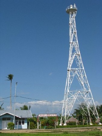
Date unknown. Active; focal plane 44 m (144 ft); two white flashes every 10 s. Approx. 30 m (98 ft) square skeletal tower with lantern and gallery, painted white, mounted atop a border patrol building. John Davidson's photo is at right, Didik Heriyanto's drone view also shows the entrance light and many miles of jungle, and Google has a satellite view. Located on the west side of the mouth of the Torasi River. Accessible only by boat. Site open, tower closed. Admiralty Q3335.
Tanpa Nama Island
2010. Active; focal plane 20 m (66 ft); white flash every 6 s. 20 m (66 ft) square skeletal tower with gallery, painted white and mounted on a platform supported by piles. No photo available but Bing has a satellite view. Located on a shoal (not an island) about 11 km (6.5 mi) southwest of the mouth of the Torasi River. Accessible only by boat. Site open, tower closed. Admiralty Q3333.

Sungai Torasi Light, Merauke, January 2017
ex-Google Plus photo by John Davidson
Merauke Area Lighthouses
A town founded by the Dutch in 1902, the provincial capital of Merauke has a population of more than 100,000 and is the principal settlement on the south coast of Indonesian Papua.

*
Merauke (Tanjung Mimiabe) (3) (Approach Range Rear)
2007(?) (station established 1905). Active; focal plane 44 m (144 ft); four white flashes every 20 s. 40 m (131 ft) tapered square skeletal tower with gallery, painted white. T. Palgunadi's closeup photo is at the top of this page, O. Gumelar has a distant street view from the beach, and Google has a satellite view. This is the landfall light for Merauke. The original lighthouse was located at the mouth of the Merau River about 4 km (2.5 mi) northwest of the present station. NGA formerly listed a 20 m (66 ft) skeletal tower; the 40 m tower was announced by the Admiralty in 2007. Located on the oceanfront about 3 km (2 mi) southwest of downtown Merauke. Site open, tower closed. ARLHS IDO-316; Admiralty Q3338; NGA 25888.
Merauke Approach East (Range Front)
Date unknown. Active; focal plane about 13 m (43 ft); green light, pattern unknown. Approx. 13 m (43 ft) square pyramidal skeletal tower, painted green and mounted on a square platform supported by piles. No photo available but Bing has a fuzzy satellite view. This light functions as the front light of an approach range with the main Merauke lighthouse (previous entry) as the rear light; it also marks the east side of the entrance channel. Located about 5 km (3 mi) off the east side of the entrance to the Merau River estuary. Accessible only by boat. Site open, tower closed. Admiralty Q3338.3.
Merauke Approach West
Date unknown. Active; focal plane 13 m (43 ft); red flash every 3 s. 13 m (43 ft) square pyramidal skeletal tower, painted red and mounted on a square platform supported by piles. No photo available and the light is not seen in Bing's current satellite view. This light marks the west side of the entrance channel. NGA lists the light as "Pelabuhan Merauke." Located about 5 km (3 mi) off the west side of the entrance to the Merau River estuary. Accessible only by boat. Site open, tower closed. Admiralty Q3338.4; NGA 25897.5.
Merauke Inner East
Date unknown. Active; focal plane 13 m (43 ft); green flash every 5 s. 13 m (43 ft) square pyramidal skeletal tower, painted green and mounted on a square platform supported by piles. No photo available but Google has a satellite view. Located just off the east side of the mouth of the Merau River. Accessible only by boat. Site open, tower closed. Admiralty Q3338.7; NGA 25899.
[Merauke Inner West]
Date unknown. Active; focal plane 13 m (43 ft); red flash every 5 s (?). 13 m (43 ft) post, painted red and mounted on a square platform supported by piles. No photo available but Google has a satellite view. Located just off the west side of the mouth of the Merau River. Accessible only by boat. Site open, tower closed. Admiralty Q3338.8.
Sungai Merau (Merauke) Range Front
Date unknown. Active; focal plane 14 m (46 ft); white flash every 4 s. 9 m (30 ft) square cylindrical skeletal tower with gallery, painted white and mounted on a square concrete base. The tower also carries a triangular slatted daymark, point up. No photo available but Google has a satellite view. This is the entrance range for the Merau River estuary leading to the port of Merauke. Located on the north side of an eastward bend of the estuary. Site status unknown. Admiralty Q3339; NGA 25892.
Sungai Merau (Merauke) Range Rear
Date unknown. Active; focal plane 21 m (69 ft); white flash every 3 s. 16 m (52 ft) square cylindrical skeletal tower with gallery, painted white. The tower also carries a triangular slatted daymark, point down. No photo available but Google has a satellite view. Located on the north side of the estuary about 3.5 km (2 mi) northwest of the town and 300 m (330 yd) northeast of the front light. Site status unknown. ARLHS IDO-169; Admiralty Q3339.1; NGA 25896.
* Pelabuhan Merauke
Date unknown. Active; focal plane 25 m (82 ft); white flash every 6 s. 25 m (82 ft) square skeletal tower, mounted on a square platform supported by piles. Lighthouse painted white. Liuzz Sulo Junior has a drone view of the light (also seen at right), a photo is available, Yudhan Lifes has a view from the docks, the tower is visible in Brawijaya Mandiri's aerial photo of Merauke, and Google has a satellite view. Located in the Merau River estuary adjacent to the docks at Merauke. Easily seen from the waterfront. Site open, tower closed. ARLHS IDO-284; Admiralty Q3339.2; NGA 25890.
#Yatum (Matara) (?)
Date unknown. Listed as active; focal plane 25 m (82 ft); white flash every 6 s. Described as a 25 m (82 ft) iron skeletal towe=. No photo available. It seems clear that this light no longer exists. Google's satellite view shows what might be remnants of a light station just north of the listed location shown by the pin. There is no 25 m tower anywhere nearby. Located near the beachfront at Matara, about 10 km (6 mi) north of Merauke. Site status unknown. ARLHS IDO-355; Admiralty Q3339.6; NGA 25900.

Pelabuhan Merauke Light, Merauke, February 2019
Google Maps photo by Liuzz Sulo Junior

Iwa Bay Lighthouses
Tanjung Mawal
Date unknown. Active; focal plane 13 m (43 ft); white flash every 3 s. 13 m (43 ft) concrete post with gallery mounted on a square concrete pier supported by piles. Entire lighthouse is white. No photo available but Bing has a satellite view. Located off a river entrance about 80 km (50 mi) northwest of Merauke. Accessible only by boat. Site open, tower closed. Admiralty Q3339.8; NGA 25902.
Pulau Habee
Date unknown. Active; focal plane 35 m (115 ft); white flash every 4 s. Approx. 30 m (98 ft) square skeletal tower with gallery, painted white. No photo available but a visitor has several views from the top of the tower and Bing has a satellite view. NGA lists a 26 ft tower for this location but has the higher focal plane; perhaps the tower height is 26 m. Located on an island about 8 km (5 mi) off the coast southeast of Gelib. Accessible only by boat. Site open, and apparently the tower can be climbed. Admiralty Q3340; NGA 25904.

Yos Sudarso (Dolok) Island Area Lighthouses
Yos Sudarso (Dolok) Island is a leaf-shaped island 165 km (103 mi) long that extends into the Arafura Sea; it is separated from the mainland by the narrow channel of the Muli Strait (Selat Muli).

Ujung Komoran
Date unknown. Active; focal plane 12 m (39 ft); red flash every 4 s. 12 m (39 ft) square red skeletal tower mounted on a platform supported by piles. No photo available and the light is not shown in Google's satellite view. NGA lists this light as Selat Muli. Located on a shoal about 5 km (3 mi) off Cape Komoran and the entrance to Selat Muli. Accessible only by boat. Site open, tower closed. Admiralty Q3340.5; NGA 25906.
Selat Muli
Date unknown. Active; focal plane 14 m (46 ft); green flash every 3 s. 14 m (46 ft) round hourglass-shaped fiberglass tower. Entire lighthouse is green. No photo available but Google has a satellite view. Selat Muli (Muli Strait) is a narrow waterway separating the large Dolok (Kimaan) Island from the mainland, about 165 km (100 mi) west of Merauke. Located on the east side of the entrance to the strait. Accessible only by boat. Site open, tower closed. Admiralty Q3340.51; NGA 25906.1.
Kimaam (Kimaan)
Date unknown. Active; focal plane 23 m (75 ft); white flash every 6 s. Approx. 20 m (66 ft) skeletal tower, mounted on a square equipment building. Adi Saputra has a 2022 photo, a view from the strait (also seen at right) and an aerial view (3/4 the way down the page) are available, and Google has a satellite view. Located at the base of the town pier at Kimaan, a settlement on Dolok Island on the west side of the Muli Strait. Site open, tower closed. ARLHS IDO-148; Admiralty Q3340.52; NGA 25906.3.
 

Kimaam Light, Kimaam, May 2015
Google Maps photo by muhammad _j.d
 
Waan (Wan)
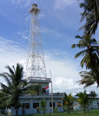
2009. Active (?); focal plane about 50 m (164 ft); white light, pattern unknown. Approx. 42 m (138 ft) square skeletal tower with lantern and gallery mounted on a square tower atop a coast guard station. Rafael Kapura's photo is at right, amateur radio operators have a more distant view (halfway down the page), and Google has a satellite view. Located at Waan, a small settlement near Cape Salah, the southwestern tip of Dolok Island. Site open, tower closed. This major lighthouse is not listed by the Admiralty and not charted by Navionics.
Ujung Salah (?)
Date unknown. Active; focal plane unknown; white light, pattern unknown. Beacon on a platform supported by piles. No photo available and the light is not seen in Bing's satellite view of the listed location. Located just off the southwestern tip of Pulau Yos Sudarso. Accessible only by boat. Site open, tower closed. Admiralty Q3340.53.
Ujung Dolok (Tanjung Kolff)
Date unknown. Active; focal plane 13 m (43 ft); white flash every 3 s. 13 m (43 ft) square white skeletal tower on a platform supported by piles. No photo available and Google has only an indistinct satellite view. Located about 500 m (0.3 mi) offshore of the central north coast of Pulau Yos Sudarso (there is no actual cape in this area). Accessible only by boat. Site open, tower closed. Admiralty Q3340.55; NGA 25906.7.
Ujung Lumpur (Modderhock)
Date unknown. Active; focal plane 13 m (43 ft); green flash every 4 s. 13 m (43 ft) round hourglass-shaped fiberglass tower. Entire lighthouse is green. No photo available but Google has a satellite view. Located about 3 km (2 mi) offshore on the south side of the Digul River estuary entrance. Accessible only by boat. Site open, tower closed. Admiralty Q3340.68; NGA 25907.2.

Waan Light, Merauke, July 2011
ex-Google Plus photo by Rafael Kapura

Southwest Coast Lighthouses

South Papua Province: Mappi Regency (Digul River) Lighthouses
Habeeaman
Date unknown. Active; focal plane 14 m (46 ft); green flash every 5 s. 14 m (46 ft) "beacon." Entire lighthouse is green. No photo available but Google has a distant satellite view. Located on the south side of the Digul River channel about 35 km (22 mi) east of the Ujung Lumpur light. Accessible only by boat. Site open, tower closed. Admiralty Q3340.67; NGA 25907.15.
* Pelabuhan Bade
Date unknown. Active; focal plane about 10 m (33 ft); white light, pattern unknown. Approx. 8 m (26 ft) round white barbell-shaped fiberglass tower. Asriel Tonglo Bulawan has a distant photo (light seen right of center, through the fence) and the light is hard to see in Google's satellite view. Located at Bade, a small port on the Digul River. Site open, tower closed. Not listed by the Admiralty.
Sungai Digul Entrance
Date unknown. Active; focal plane 13 m (43 ft); white flash every 3 s. Described only as a "white beacon." Google's satellite view shows no light at the listed location but another Google satellite view might show the light centered on an island about 3 km (2 mi) west northwest. Located in the north side of the entrance to the Digul River. Site status unknown. Admiralty Q3340.65; NGA 25907.1.
Ujung Digul (Sungai Digul, Digul River)
Date unknown. Active; focal plane 12 m (39 ft); white light, 1 s on, 1 s off. 12 m (39 ft) square white skeletal tower mounted on a platform supported by piles. No photo available and the tower is not seen in Bing's satellite view. Located at the entrance to the estuary of the Digul River about 30 km (19 mi) north of Dolok Island. Accessible only by boat. Site open, tower closed. Admiralty Q3340.7; NGA 25907.

South Papua Province: Asmat Regency Lighthouses
Birufu (Kampung River) (?)
Date unknown. Active; focal plane 13 m (43 ft); green flash every 3 s. 13 m (43 ft) round hourglass-shaped fiberglass tower. Entire lighthouse is green. No photo available and the light is not shown in Bing's satellite view. Located on the south side of the Kampung River estuary entrance about 50 km (30 mi) southeast of Agats. Accessible only by boat. Site open, tower closed. Admiralty Q3340.95; NGA 25907.3.
Atay
Date unknown. Active; focal plane 14 m (46 ft); red flash every 5 s. 14 m (46 ft) red tower, probably skeletal, on a platform supported by piles. No photo available and the light is not shown in Google's satellite view. Located about 16 km (10 mi) west northwest of the Kampung River entrance. Accessible only by boat. Site open, tower closed. Admiralty Q3340.94; NGA 25907.25.
Flamingo Bay
Date unknown. Active; focal plane 13 m (43 ft); green flash every 3 s. 13 m (43 ft) green tower, probably skeletal, on a platform supported by piles. No photo available and the light is not shown in Google's satellite view. Located about 16 km (10 mi) southwest of entrance to the Asewets River and the port of Agats. Acessible only by boat. Site open, tower closed. Admiralty Q3340.8; NGA 25907.4.
Sungai Asewets Entrance (Agats)
Date unknown. Active; focal plane 13 m (43 ft); white light, 1 s on, 1 s off. 13 m (43 ft) tower, probably skeletal, on a platform supported by piles. No photo available and the light is not shown in Google's satellite view. Located in the mouth of the Asewets River. Acessible only by boat. Site open, tower closed. Admiralty Q3340.85; NGA 25907.6.

Agats Light, Agats, March 2018
photo copyright 'I Made Genta' courtesy of Indri Juwono; used by permission
Sungai Asewets South
Date unknown. Active; focal plane 13 m (43 ft); green flash every 3 s. 13 m (43 ft) green tower, probably skeletal. No photo available but Google has a satellite view. Located on the south side of the Asewets River entrance. Site status unknown. Admiralty Q3340.9; NGA 25907.6.5
Sungai Asewets North
2015. Active; focal plane 25 m (82 ft); white flash every 4 s. 20 m (66 ft) square skeletal tower, painted white. No photo available but Bing has a distant satellite view. Located on the north side of the entrance to the Asewets River estuary. Site open, tower closed. Admiralty Q3340.92.
* Pelabuhan Agats
Date unknown. Active; focal plane 23 m (75 ft); white flash every 3 s. 23 m (75 ft) square white skeletal tower mounted on a platform supported by piles. A photo is above right, Ojhon Belite has a 2017 photo, a 2022 photo is available, and Google has a satellite view of the waterfront. Located on the south side of the Asewets (Utumbuwe) River estuary in the regency capital of Agats, a town of about 25,000 residents, in the southwest coast of Papua. Site open, tower closed. Admiralty Q3340.87; NGA 25907.62.
Pulau Laag
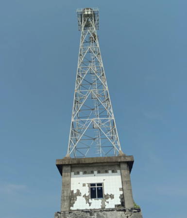
Date unknown. Active; focal plane 42 m (138 ft); two white flashes every 10 s. 43 m (141 ft) square skeletal tower with lantern and gallery mounted on a square concrete skeletal tower. Mudi Abee Shidqi has a closeup 2023 photo and a second photo (seen at right) and Google has a satellite view. Remarkably, this lighthouse is located almost 32 km (20 mi) northwest of its listed location. Located at the southern tip of Pulau Laag, about 75 km (47 mi) northwest of Agats. Accessible only by boat. Site open, tower closed. Admiralty Q3340.98.

Central Papua Province: Mimika Regency Lighthouse
Sungai Keakwa (Nime)
Date unknown. Active; focal plane 16 m (52 ft); two white flashes every 12.5 s. 15 m (49 ft) skeletal tower, painted white. No photo available, and the tower has not been found in Google's satellite view of the area. Located at Keakwa, near the western border of Papua Province. Site status unknown. Admiralty Q3343; NGA 25908.

Pulau Laag Light, Asmat Regency, November 2023
Google Maps photo by Mudi Abee Shidqi

Information available on lost lighthouses:

Notable faux lighthouses:

Adjoining pages: East: Southern Papua New Guinea | Southwest: Southeastern Maluku | Northwest: Western Papua South Coast

Return to the Lighthouse Directory index | Ratings key

Posted December 31, 2008. Checked and revised November 26, 2023. Lighthouses: 35. Site copyright 2023 Russ Rowlett and the University of North Carolina at Chapel Hill.