Lighthouses of Indonesia: Lampung, Sumatra

Indonesia is a huge country of Southeast Asia, stretching along both sides of the Equator for more than 46 degrees of longitude (roughly 5100 km or 3200 miles). It occupies 17,504 islands, by official count, including more than 6000 inhabited islands. It is the world's fourth most populous nation with a population currently estinated at about 280 million. More than half of the population lives on the island of Java. Other major islands include Sumatra in the west, Borneo (shared with Malaysia and Brunei) in the northwest, Sulawesi in the northeast, and the eastern half of New Guinea in the far east. Other well known islands include Bali, Lombok, Sumbawa, Flores, and Timor (shared with independent East Timor) along the south side of the country.

The unification of the country was accomplished over many years of struggle by Dutch colonial authorities. The Dutch East India Company was founded in 1602 to establish and extend Dutch administration, and after the company folded in 1800 the Netherlands established the Dutch East Indies colony and gradually extended its boundaries to include the present territory of Indonesia. During World War II Japan occupied the islands from March 1942 to the end of the war in 1945. The Republic of Indonesia proclaimed its independence immediately after the war ended and following some conflict the Netherlands accepted the country's independence in 1949.

Sumatra (Sumatera in Indonesian) is the world's sixth largest island and the westernmost of the major islands of Indonesia. It is separated from Malaysia to the north by the Malacca Strait, from Kalimantan (Borneo) to the northeast by the broad Karimata Strait, and from Java to the southeast by the Sunda Strait. Its south coast faces the open Indian Ocean.

Indonesia is divided into 38 provinces (provinsi) and the provinces are subdivided into county units called regencies (kabupaten). Sumatra includes eight of the provinces. This page includes lighthouses of Lampung Province, located at the southern tip of Sumatra facing Java across the Sunda Strait.

More than 700 languages are spoken in Indonesia. The official national language, Indonesian (Bahasa Indonesia), was standardized from a form of Malay that served as a lingua franca across the archipelago. In Indonesian a lighthouse is a mercusuar or a menara suar. Tanjung is a cape, ujung is a headland or point of land, bukit is a hill, sungai is a river, kuala or muara is an estuary or river mouth, pulau is an island, karang is a reef, batu is a rock, laut is a sea, selat is a strait, teluk is a bay, pelabuhan is a harbor, and labuhan is a port.

Aids to navigation in Indonesia are operated and maintained by the Directorate of Marine Navigation within the Directorate General of Sea Transportation.

ARLHS numbers are from the ARLHS World List of Lights. Admiralty numbers are from volume Q of the Admiralty List of Lights & Fog Signals. U.S. NGA List numbers are from Publication 112.

General Sources
Lighthouses in Indonesia
Photos by various photographers available from Wikimedia; most of the photos are historic.
World of Lighthouses - Indonesia
Photos by various photographers available from Lightphotos.net.
Online List of Lights - Indonesia
Photos by various photographers posted by Alexander Trabas.
GPS Nautical Charts
Navigational chart information for southeastern Sumatra.
Navionics Charts
Navigational chart for southeastern Sumatra.

Tanjung Cukuhbalambing (Vlakken Hoek) Light, August 2016
ex-Google Plus photo by hasan s
East Lampung Regency (Java Sea) Lighthouses
Tanjung Bungin
Date unknown. Active; focal plane 12 m (39 ft); white flash every 4 s. 12 m (39 ft) "white beacon" on a platform supported by piles. No photo available and the light is not seen in Google's satellite view. Located about 16 km (10 mi) off the Sumatran coast roughly halfway between Pulau Maspari and the entrance to the Sunda Strait. Accessible only by boat. Site open, tower closed. Admiralty Q1045.5; NGA 23383.
Gosong Serdang
Date unknown. Active; focal plane 12 m (39 ft); two white flashes every 10 s. 12 m (39 ft) tower painted black with one red horizontal band and mounted on a platform supported by piles. No photo available and the light is not seen in Google's satellite view. Located on an isolated shoal, only 5 m (16 ft) deep, near the center of the line of approach to the Sunda Strait about 40 km (25 mi) off Tanjung Sekopong. Accessible only by boat. Site open, tower closed. Admiralty Q1045; NGA 23382.
Pulau Segama
Date unknown. Active; focal plane 45 m (148 ft); white flash every 5 s. 40 m (131 ft) square tapered skeletal tower with lantern and gallery, painted white. Several coast guard station buildings. A photo is at right, Noob Gaming has a 2020 view from the sea, the light is seen at the start of a 2022 video, and Bing has an indistinct satellite view. This lighthouse guides vessels approaching the northern entrance to Sunda Strait. Located on a small island about 30 km (19 mi) off the Sumatran coast and 80 km (50 mi) north of the entrance to the strait. Accessible only by boat. Site status unknown. ARLHS IDO-246; Admiralty Q1043; NGA 23380.
* Maringgai
Date unknown. Active; focal plane 14 m (46 ft); white flash every 3 s. Approx. 12 m (39 ft) round barbell-shaped white tower. M. Aldhiansyah has a 2021 photo and Bing has a satellite view. NGA misspells the name as Maginggai. Located on the waterfront just north of the harbor at Maringgai, a fishing port in southeast East Lampung Regency. Site open, tower closed. Admiralty Q0929.6; NGA 23015.

South Lampung Regency: Sunda Strait North Entrance Lighthouses
The Sunda Strait, separating Sumatra from Java, is the most important passage through the islands of Indonesia. The strait is a broad bay at its southwestern entrance from the Indian Ocean, but it narrows to a minimum width of 24 km (15 mi) at its northeastern entrance from the Java Sea. Lighthouses on the east side of the strait are described on the Southwestern Java page. Lampung Bay is a broad, relatively shallow inlet on the north side of the Strait.

Pulau Mundu
Date unknown. Active; focal plane 23 m (75 ft); white flash every 6 s. Approx. 18 m (59 ft) square skeletal tower with gallery, painted white. No photo available but Google has a satellite view. Rahman Hanif has a Google Maps video taken from the top of the lighthouse. Located on a small island just off the coast about 8 km (5 mi) north of Ketapang. Accessible only by boat. Site status unknown. Admiralty Q0929.5; NGA 23014.
Karang Kanggalan (Ujung Kanggalan)
Date unknown. Active; focal plane 13 m (43 ft); white flash every 5 s. 13 m (43 ft) square skeletal tower on a square platform supported by piles. No photo available but Google has an indistinct satellite view. Located just off Ujung Kanggalan, which is actually a tombolo (an island connected to the mainland by a sandbar), about 5 km (3 mi) south of Ketapang. Accessible only by boat. Site open, tower closed. Admiralty Q0929.3; NGA 23013.5.
Pulau Segama Light
Pulau Segama Light, Java Sea, June 2004
photo copyright Indonesia Sea Turtle Foundation
permission requested
Gosong Barak
Date unknown. Active; focal plane 10 m (33 ft); quick-flashing yellow light. 10 m (33 ft) round robust post, painted yellow. This light has been listed as yellow since at least 2008, yet it is green in a 2011 photo by Katamsi Suryo Purnomo. Google has a satellite view. Located at the east end of a reef just off the south end of Pulau Lampung on the approach to Bakauheni. Accessible only by boat. Site open, tower closed. Admiralty Q0928.6; NGA 23009.2.
[Tanjung Katila (Bakauheni) (2)]
Around 2021. Active; focal plane 10 m (33 ft); two quick green flashes every 10 s. Approx. 10 m (33 ft) green post on platform supported by piles. Mukhammad Najib has a 2021 photo. This light replaced a 5 m (33 ft) round robust green post seen in Nurgi Han's 2018 photo. Google has an indistinct satellite view. This light and the next one listed are among about a dozen harbor lights guiding ferries into and out of the ferry port of Bakauheni. This is one of the busiest ferry routes in the world, linking Bakauheni on Sumatra to Merak in Java, about two hours away across the Sunda Strait. Ferries sail about every 12 minutes, day and night. Located at the north end of the Bakauheni ferry terminals, where it serves as a leading light for the inbound passage south of Pulau Rimaubalak. Accessible only by boat. Site open, tower closed. Admiralty Q0928.65; NGA 23009.4.
Pulau Kelapa Southwest
Date unknown. Active; focal plane 10 m (33 ft); six quick white flashes followed by one long white flash every 10 s. 10 m (33 ft) round robust post, upper half listed as yellow and lower half black. The upper half is white in Dea Septia's 2018 photo. Bing has an indistinct satellite view. Located at the south end of shoal off Dock 5, the southernmost dock at Bakauheni. Accessible only by boat. Site open, tower closed. Admiralty Q0929.2; NGA 23013.
Pulau Dua Kecil
Date unknown. Active; focal plane about 13 m (43 ft); green light, pattern unknown. Approx. 13 m (43 ft) round green fiberglass tower on a platform supported by piles. Ari Saputra has a 2021 photo and Google has an indistinct satellite view. Located off the south side of an island on the southern approach to Bakauheni. Accessible only by boat. Site open, tower closed. Admiralty Q0928.4.
Pulau Kandang Kecil
Date unknown. Active; focal plane about 13 m (43 ft); red light, pattern unknown. Approx. 13 m (43 ft) square skeletal tower on a platform supported by piles. Teuku Fahmi has a 2019 distant view and Bing has an indistinct satellite view. Located off the north side of an island on the southern approach to Bakauheni. Accessible only by boat. Site open, tower closed. Admiralty Q0928.3.
Pulau Panjurit
Date unknown. Active; focal plane 54 m (177 ft); three white flashes every 8 s. 6 m (20 ft) "white beacon." No photo available and the light is not seen in Google's satellite view. Despite its small size this is an important light. Located at the northeast corner of an island on the north side of the entrance to the Sunda Strait. Site status unknown. Admiralty Q0928; NGA 23004.

South Lampung Regency: Eastern Lampung Bay Lighthouses
Tanjung Tua
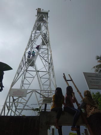
Date unknown. Active; focal plane 50 m (164 ft); three white flashes every 10 s. 15 m (49 ft) skeletal tower, painted white. Mazfa Chanel's photo is at right, Tantri Cutte has a view from the sea, Robi Saputra has a 2016 street view taken in the base of the tower, and Google has an indistinct satellite view. This lighthouse is at the southeastern corner of Sumatra; it marks the west side of the northern entrance to Sunda Strait and the east side of the entrance to Lampung Bay. Site open, and obviously it is possible to climb the tower. ARLHS IDO-331; Admiralty Q0927; NGA 23016.
Pulau Sebuku (Ujung Cukubanding, Cukuh Banding)
Date unknown. Active; focal plane 35 m (115 ft); white flash every 5 s. 10 m (33 ft) (?) square skeletal tower, painted white. No photo available but Google has a satellite view of the station. The tower looks taller than 10 m in the satellite view. Located on the north point of Sebuku, an island in the mouth of Lampung Bay. Accessible only by boat. Site status unknown. Admiralty Q0926; NGA 23024.
Pulau Tiga
Date unknown. Active; focal plane 30 m (98 ft); two white flashes every 6 s. 15 m (49 ft) tower, probably skeletal, painted black with a red horizontal band. No photo available but Google has an indistinct satellite view. Located atop the southeasternmost of three small islets in the center of the entrance to Lampung Bay. Accessible only by boat. Site status unknown. Admiralty Q0925; NGA 23028.

Tanjung Tua Light, Lampung Province, June 2019
Google Maps photo by Mazfa Chanel
Ujung Cukucimanuk (Pulau Cimanuk)
Date unknown. Active; focal plane 23 m (75 ft); two white flashes every 7 s. 15 m (49 ft) square pyramidal skeletal tower painted white. A very distant view from the sea is available and Google has an indistinct satellite view. Located on a tombolo (an island connected to the mainland by a narrow isthmus) on the east side of Lampung Bay. Site status unknown. Admiralty Q0923.5; NGA 23036.
Pulau Condonglaut (Condong Laut, Cendung Laut)
Date unknown. Active; focal plane 28 m (92 ft); green flash every 5 s. 12 m (39 ft) square skeletal tower painted green. No photo available but Bing has an indistinct satellite view. Located on an island off the east coast of Lampung Bay, guiding vessels on the approach to Bandar Panjang. Accessible only by boat. Site status unknown. Admiralty Q0923; NGA 23040.
Tarahan Oil Terminal
Date unknown. Active; focal plane 15 m (49 ft); white flash every 5 s. 12 m (39 ft) square white skeletal tower. No photo available but Bing has an indistinct satellite view. Located on the waterfront at an oil terminal about 15 km (9 mi) southeast of Bandar Lampung. NGA lists the light only as "Lampung Bay." Site and tower closed. Admiralty Q0922.9; NGA 23042.

Bandar Lampung City Lighthouses
Bandar Lampung is a city of 1.2 million residents, the provincial capital and the metropolis of southeastern Sumatra. The city is built at the head of Lampung Bay.
Tarahan Coal Terminal
Date unknown. Active; focal plane 16 m (52 ft); white flash every 5 s. 12 m (39 ft) square white skeletal tower. No photo available but Bing has an indistinct satellite view. Located on the waterfront at a coal terminal about 1 km (0.6 mi) northwest of the oil terminal light. Site and tower closed. Admiralty Q0922.86.
Panjang (Bandar Lampung) Oil Terminal
Date unknown. Active; focal plane 20 m (66 ft); white flash every 5 s. Approx. 18 m (59 ft) square white skeletal tower. Google has a street view and the shadow of the tower is prominent in Google's satellite view. Located on the waterfront of the oil terminal in the Panjang District on the east side of Bandar Lampung harbor. Site and tower closed. Admiralty Q0922.2.
#Panjang (Koeala)
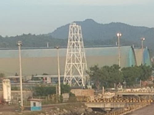
Date unknown. Removed in 2019 but still listed with focal plane 41 m (134 ft); white or red light depending on direction, 2 s on, 3 s off. This was a 40 m (131 ft) square white skeletal tower. A 2017 photo is available but the tower is not shown in Google's satellite view. Formerly located in the Semen Baturaja complex near the oil terminal in eastern Bandar Lampung. Site and tower closed. Admiralty Q0922; NGA 23044.

Pelabuhan Panjang Light, Bandar Lampung, May 2019
Google Maps photo by Lovina Mutiara
Panjang Entrance
Date unknown. Active; focal plane about 13 m (43 ft); green light, pattern unknown. Approx. 13 m (43 ft) round green barbell-shaped fiberglass tower on a platform supported by piles. Yudha Febrian has a distant drone view (light is in the center of the image) and Google has a satellite view. Located at the edge of a shoal area off the waterfront of Bandar Lampung. Accessible only by boat. Site open, tower closed. Admiralty Q0922.6.
Pelabuhan Panjang
Date unknown. Active; focal plane about 22 m (72 ft); white light, pattern unknown. Approx. 20 m (66 ft) square white skeletal tower. Lovina Mutiara has the photo seen above right, Yudha Febrian has a 2022 street view, and Google has a satellite view. Located on the waterfront of Panjang harbor at the southeastern edge of the city. Site and tower closed. Admiralty Q0922.1.
Kunyit (Kunjit, Teluk Lampung)
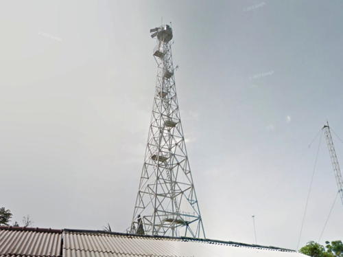
Date unknown. Active; focal plane 44 m (144 ft); white flash every 3 s. 40 m (131 ft) tapered square white skeletal tower with gallery. Google's street view is at right, Lina Pesisir has a closeup photo, another photo is available, Malik Ismail has a distant view, and Google also has a satellite view. Located behind the waterfront in the Bumi Waras District of Bandar Lampung. Site open (but not in a good neighborhood), tower closed. Admiralty Q0920.5; NGA 23052.
Karang Telukbetung
Date unknown. Active; focal plane 18 m (60 ft); two red flashes every 10 s. 18 m (60 ft) square cylindrical red skeletal tower on a square platform supported by piles. No photo available but Google has a satellite view. Located on a reef about 3 km (2 mi) southwest of Bandar Lampung. Accessible only by boat. Site open, tower closed. Admiralty Q0920; NGA 23048.

Kunyit Light, Bandar Lampung, July 2018
Google Maps street view

Pesawaran Regency (Western Lampung Bay) Lighthouses
Karang Pamungutan
Date unknown. Active; focal plane 14 m (46 ft); white flash every 4 s. 14 m (46 ft) round white fiberglass tower. The light is visible at the left edge of a photo of the bay and Bing has a fuzzy satellite view. Located on a sandbar in Lampung Bay about 6 km (3.5 mi) south of Bandar Lampung. Accessible only by boat. Site open, tower closed. Admiralty Q0917.
Maitem (Pulau Maitem)
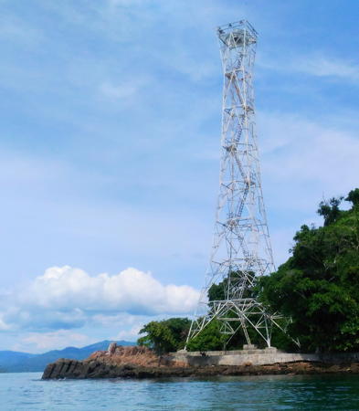
Date unknown. Active; focal plane 42 m (138 ft); white flash every 8 s. Approx. 40 m (131 ft) square tapered skeletal tower with lantern and gallery, painted white. Part of Eka Bond's photo is at right and Bing has a satellite view. Located at the southeastern tip of an island projecting into the west side of Lampung Bay. Accessible only by boat. Site status unknown. Admiralty Q0923.2; NGA 23064.
Serdang (Pulau Serdang)
Date unknown. Active; focal plane 62 m (203 ft); three white flashes every 10 s. 40 m (131 ft) square skeletal tower with lantern and gallery, painted white; lantern painted red. Fajri Gitu has a view from the sea and a second view showing the lower portion of the tower and Google has a satellite view. This lighthouse is on an island on the west side of the Sunda Strait in the mouth of Lampung Bay. Accessible only by boat. Site status unknown. ARLHS IDO-276; Admiralty Q0926.5; NGA 23020.
Pulau Sijebi
Date unknown. Active; focal plane unknown; two white flashes every 9 s. Approx. 12 m (39 ft) square skeletal tower. No photo available but Google has an indistinct satellite view. Located on the easternmost of several islands on the west side of the mouth of Lampung Bay. Accessible only by boat. Site status unknown. dmiralty Q0926.7; NGA 23020.5.

South Lampung Regency: Krakatau Lighthouse
Pulau Rakata (Krakatau)
Date unknown. Active; focal plane 13 m (43 ft); white flash every 4 s. 13 m (43 ft) round white fiberglass tower mounted on a platform supported by piles. No photo available but Bing has a satellite view. Located in the middle of the Sunda Strait, Krakatau (Krakatoa) is a famous volcano that exploded catastrophically on 27 August 1883, killing more than 36,000 people. A group of islands, remnants of the explosion, surround the caldera of the volcano, Pulau Rakata on the southeast side being the largest. The light is just off the southeast coast of Pulau Rakata. Accessible only by boat. Site status unknown. Admiralty Q0927.5; NGA 23022.

Pulau Maitem Light, Bay of Panjang, September 2016
ex-Google Plus photo by Eka Bond

Pesisir Barat Regency (Indian Ocean) Lighthouses
Tanjung Cukuhbalambing (Vlakken Hoek, Balimbing, Belimbing)
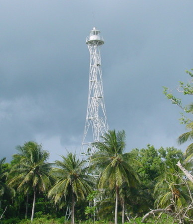
1880. Active; focal plane 63 m (207 ft); two white flashes every 10 s. 58 m (190 ft) 16-sided cast iron tower with lantern and gallery, painted white. A 2016 closeup is at the top of this page, Arif Prasetyo has a closeup photo (2nd photo on the page), Lightphotos.net has a nice view and second view by Mikhail Tsyganov, and Bing has a good satellite view of the station. Several coast guard station buildings. Endangered; Prasetyo visited in early 2011 and found the lighthouse to be in "fragile" condition. A September 2018 photo shows some repair work in progress. Prefabricated at The Hague by Enthoven and Co., this historic lighthouse marks the southern point of Sumatra; it is a landfall light for eastbound ships approaching the Sunda Strait. The Rijksmuseum has a scale model. The tsunami waves created by the eruption of Krakatoa in August 1883 damaged the first floor of the lighthouse and destroyed several station buildings. The light station is now included in the Tambling Wildlife Nature Conservation preserve. Located on the point of the cape near Balimbing. Site status unknown, but there is road access to the area. ARLHS IDO-082; Admiralty Q0914; NGA 23076.
Pulau Batu Kecil
2007. Active; focal plane 45 m (148 ft); white flash every 6 s. 40 m (131 ft) square pyramidal skeletal with lantern and gallery mounted on a 2-story coast guard station building. Lighthouse painted white. No photo available but Google has a satellite view. This is a landfall light for the Sunda Strait, replacing the Vlakken Hoek lighthouse in that function. Located on a small island about 13 km (8 mi) west of Vlakken Hoek. Accessible only by boat. Site status unknown. Admiralty Q0913; NGA 23077.
Ujung Cukubatuberagam
Date unknown. Active; focal plane 32 m (105 ft); white flash every 7.5 s. Approx. 25 m (82 ft) square skeletal tower painted white. No photo available but Google has a satellite view. Located on a hook-shaped promontory about 50 km (30 mi) northwest of the historic Vlakken Hoek lighthouse. Site status unknown. Admiralty Q0911; NGA 23086.
Ujung Walor (Walur)
Date unknown. Active; focal plane 42 m (138 ft); continuous white light. 40 m (131 ft) skeletal tower, painted white. Several 1-story coast guard station buildings.Aditya Karnawiredja has a distant drone view and Google has a satellite view. Located on a promontory near Krui. Site status unknown. ARLHS IDO-353; Admiralty Q0910; NGA 23088.
Krui (Tanjung Salobu) (2)
Date unknown (station established 1904 (?)). Active; focal plane 35 m (115 ft); white flash every 5 s. 13 m (43 ft) post rising from a square white equipment shelter. square pyramidal skeletal tower, painted white. A very distant view is available and Google has a street view and an indistinct satellite view. NGA describes a skeletal tower. Krui is popular with surfers and has a number of resorts. Located on a steep bluff near Krui. Site status unknown. ARLHS IDO-151; Admiralty Q0906; NGA 23092.
Pulau Pisang (Teluk Krui)
Date unknown. Active; focal plane 76 m (249 ft); one long white flash every 15 s. 31 m (102 ft) skeletal tower, painted white. Apri Yansa's photo is at right, Said Ardi has a 2018 photo, Egi Ramdhani has a closeup, Fibriand Andika has an aerial view, and Google has a satellite view. Located on an island about 15 km (9 mi) northwest of Krui. Accessible only by boat. Site status unknown. Admiralty Q0904; NGA 23096.

Pulau Pisang Light, Krui, June 2018
ex-Google Plus photo by Apri Yansa

Information available on lost lighthouses:

Notable faux lighthouses:

Adjoining pages: North: Southeastern Sumatra | Southeast: Southwestern Java | Northwest: Southwestern Sumatra

Return to the Lighthouse Directory index | Ratings key

Posted April 13, 2006. Checked and revised February 3, 2024. Lighthouses: 35. Site copyright 2023 Russ Rowlett and the University of North Carolina at Chapel Hill.