Lighthouses of Indonesia: Mentawai Islands, West Sumatra

Indonesia is a huge country of Southeast Asia, stretching along both sides of the Equator for more than 46 degrees of longitude (roughly 5100 km or 3200 miles). It occupies 17,504 islands, by official count, including more than 6000 inhabited islands. It is the world's fourth most populous nation with a population currently estinated at about 280 million. More than half of the population lives on the island of Java. Other major islands include Sumatra in the west, Borneo (shared with Malaysia and Brunei) in the northwest, Sulawesi in the northeast, and the eastern half of New Guinea in the far east. Other well known islands include Bali, Lombok, Sumbawa, Flores, and Timor (shared with independent East Timor) along the south side of the country.

The unification of the country was accomplished over many years of struggle by Dutch colonial authorities. The Dutch East India Company was founded in 1602 to establish and extend Dutch administration, and after the company folded in 1800 the Netherlands established the Dutch East Indies colony and gradually extended its boundaries to include the present territory of Indonesia. During World War II Japan occupied the islands from March 1942 to the end of the war in 1945. The Republic of Indonesia proclaimed its independence immediately after the war ended and following some conflict the Netherlands accepted the country's independence in 1949.

Sumatra (Sumatera in the Indonesian spelling) is the world's sixth largest island and the westernmost of the major islands of Indonesia. It is separated from Malaysia to the north by the Malacca Strait, from Borneo to the northeast by the broad Karimata Strait, and from Java to the southeast by the Sunda Strait. Its south coast faces the open Indian Ocean.

Indonesia is divided into 38 provinces (provinsi) and the provinces are subdivided into county units called regencies (kabupaten). Sumatra includes eight of the provinces. The Mentawai Islands are a chain of islands lying about 150 km (90 mi) off the coast of West Sumatra Province and organized as a regency of that province. Populated with about 90,000 residents, the islands are a favorite of surfers. From south to north the four major islands are South Pagai, North Pagai, Sipura, and Siberut. Mainland lighthouses of West Sumatra Province are described on the Western Sumatra page.

More than 700 languages are spoken in Indonesia. The official national language, Indonesian (Bahasa Indonesia), was standardized from a form of Malay that served as a lingua franca across the archipelago. In Indonesian a lighthouse is a mercusuar or a menara suar. Tanjung is a cape, ujung is a headland or point of land, bukit is a hill, sungai is a river, kuala or muara is an estuary or river mouth, pulau is an island, karang is a reef, batu is a rock, laut is a sea, selat is a strait, teluk is a bay, pelabuhan is a harbor, and labuhan is a port.

Aids to navigation in Indonesia are operated and maintained by the Directorate of Marine Navigation within the Directorate General of Sea Transportation.

ARLHS numbers are from the ARLHS World List of Lights. Admiralty numbers are from volume Q of the Admiralty List of Lights & Fog Signals. U.S. NGA List numbers are from Publication 112.

General Sources
Online List of Lights - Indonesia - Sumatra
Photos by various photographers posted by Alexander Trabas.
World Lights - Indonesia
Historic postcard views from the collection of Michel Forand.
Lighthouses in Indonesia
Photos by various photographers available from Wikimedia; most of the photos are historic.
World of Lighthouses - Indonesia
Photos by various photographers available from Lightphotos.net.
Google Maps
Satellite view of the islands.

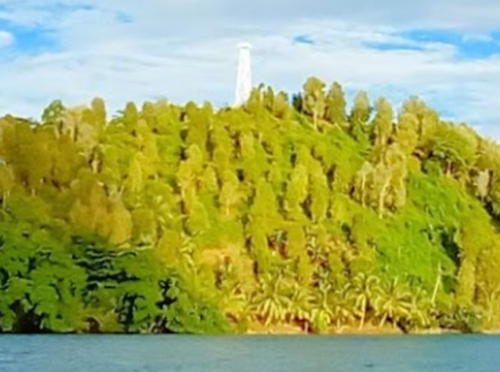
Pelabuhan Tua Pejat Light, Tua Pejat, Pulau Sipura, November 2023
Google Maps photo by Les Ardi
Pulau Pagai Selatan (South Pagai) Lighthouses
The two Pagai Islands are separated by a narrow channel, the Sikikap Strait. Together are about 135 km (85 mi) long and roughly 32 km (20 mi) wide. South Pagai has a population of about 10,000 and North Pagai has a population of about 15,000.

Tanjung Sebelua (Sibelur, Tanjung Laggaisao) (2)
Date unknown. Active; focal plane 12 m (39 ft); white flash every 4 s. 12 m (39 ft) square white skeletal tower mounted on a platform supported by piles. No photo available but Google has a satellite view. The previous light stands on a platform next to the active light. This light is about 400 m (1/4 mi) north of the Admiralty's location. Located off a headland on the east coast of Pulau Pagai Selatan. Site status unknown. Admiralty Q0883.55; NGA 23126.
Pulau Singisingi
Date unknown. Active; focal plane 14 m (46 ft); white flash every 5 s. 14 m (46 ft) square white skeletal tower mounted on a platform supported by piles. No photo available but Google has a satellite view. NGA misspells the name as Sangingi. Located on a reef off the southeast coast of South Pagai marking the entrance to the Tinopo Strait separating South Pagai from the smaller Pulau Tinopo. Accessible only by boat. Site status unknown. Admiralty Q0883.7; NGA 23124.
Sinakak
2019. Active; focal plane 12 m (39 ft); white flash every 5 s. 10 m (33 ft) square white skeletal tower mounted on a platform supported by piles. No photo available but Google has a satellite view. Located at a small village on Pulau Simatapi, an island separated by a narrow channel from the southeast coast of Pulau Pagai Selatan. Site status unknown. Admiralty Q0883.68.
Pulau Simonga (Simongguk)
Date unknown. Active; focal plane 41 m (135 ft); white flash every 8 s. Approx. 40 m (131 ft) skeletal tower, painted white. Coast guard station with half a dozen buildings. No photo available but Bing has a satellite view of the station. Located at the northern tip of a small island off the southeast coast of Pulau Pagai Selatan. Accessible only by boat. Site status unknown. Admiralty Q0883.75; NGA 23116.
Tanjung Bio
Date unknown. Active; focal plane 21 m (69 ft); white flash every 4 s. 21 m (69 ft) square skeletal tower mounted on a platform supported by piles. No photo available but Google has a satellite view that probably shows the station.. Located near the southern tip of South Pagai. Site status unknown. Admiralty Q0883.65; NGA 23115.
Pulau Sibarubaru
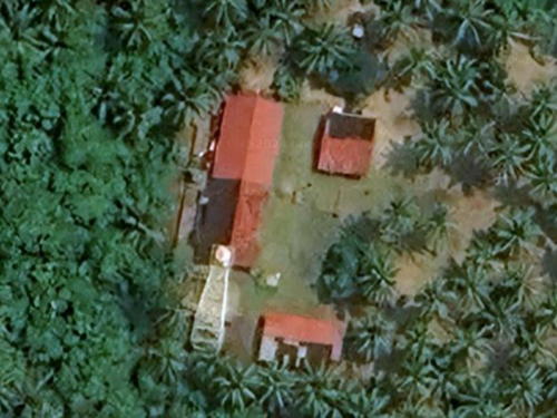
Date unknown. Active; focal plane about 45 m (148 ft); white light, characteristic unknown. Approx. 40 m (131 ft) skeletal tower, painted white. No photo available but Google has the satellite view seen at right. Located on a small island off the southwestern tip of South Pagai. Accessible only by boat. Site status unknown. Admiralty Q0883.62.
Pulau Silau (Solawi)
Date unknown. Active; focal plane 21 m (69 ft); white light, 1.5 s on, 3.5 s off. Approx. 20 m (66 ft) square white skeletal tower. No photo available nd the lighthoue has not been located. No tower is seen at the listed location on a small, uninhabited island off the northwest coast of South Pagai. It is possible the light could be offshore to the west of the island. Accessible only by boat. Site status unknown. Admiralty Q0883.6; NGA 23120.

Pulau Sibarubaru Light, South Pagai
Google Maps satellite view

Sikakap Strait Lighthouses
Si Jau Jau
Date unknown. Active; focal plane 12 m (39 ft); quick white flash every 1 s. 12 m (39 ft) tower, upper half painted black amd lower half yellow, on a platform supported by piles. No photo available but Google has a distant satellite view. Located on a dangerous shoal about 2.5 km (1.5 mi) east of the entrance to the Sikikap Strait. Accessible only by boat. Site open, tower closed. Admiralty Q0881.2.
Selat Sikakap (Sikakap Strait)
Date unknown. Active; focal plane 50 m (164 ft); white flash every 5 s. 20 m (66 ft) square white skeletal tower with gallery. Oka Sukma has the view from the sea seen at right and a very distant view from the pier in Sikakap, and Google has a satellite view. NGA lists the tower height as 20 ft; 20 m seems appropriate based to the satellite view. Located on an island in the eastern entrance to the Sikikap Strait between the islands of South and North Pagai, marking the entrance to the town of Sikikap. Accessible only by boat. Site status unknown. Admiralty Q0883; NGA 23132.
Sikakap
Date unknown. Active; focal plane 15 m (49 ft); green flash every 3 s. 15 m (49 ft) square skeletal tower on a platform supported by piles. A closeup photo is available, the light is near the left edge of Ervina P. Hasibuan's photo of the harbor and Google has an indistinct satellite view. Located off the waterfront of Sikakap. Accessible only by boat. Site open, tower closed. Admiralty Q0883.4; NGA 23134.
Pelabuhan Sikakap
Date unknown. Active; focal plane 15 m (49 ft); white flash every 5 s. 12 m (39 ft) hexagonal tower. The tower is near the left edge in Oka Sukma's 2020 view and Google has a satellite view. NGA has confused this light with Admiralty Q0883.4 but C-Map shows both lights correctly. Located in the Sikakap ferry terminal. Site status unknown. Admiralty Q0883.42.
Sibaibai
Date unknown. Active; focal plane 15 m (49 ft); white flash every 3 s. 15 m (49 ft) square skeletal tower on a platform supported by piles. No photo available but Google has an indistinct satellite view. Located on a shoal off a petroleum terminal southwest of Sikikap. Accessible only by boat. Site open, tower closed. Admiralty Q0883.46.

Selat Sikakap Light, Sikakap, Auguat 2020
Google Maps photo by Oka Sukma
Pulau Bakatpeigu
Date unknown. Active; focal plane about 12 m (39 ft); white flash every 5 s. Approx. 12 m (39 ft) round white barbell-shaped tower. No photo available but Google has a satellite view. Located just off the south side of a small island midway in the Sikakap Strait. Accessible only by boat. Site open, tower closed. Admiralty Q0883.463.
Pulau Nusa (2)
2015. Active; focal plane 12 m (39 ft); white flash every 5 s. 12 m (39 ft) "white beacon," apparently a white barbell-shaped fiberglass tower. No photo available but Google has a satellite view. Bing has a satellite view of the earlier light, 160 m (525 ft) to the south. Located on an island marking the western entrance to the Sikikap Strait. Accessible only by boat. Site status unknown. Admiralty Q0883.5; NGA 23135.

Pulau Pagai Utara (North Pagai) Lighthouses
Pulau Pinangpinang (2)
Date unknown. Active; focal plane 12 m (39 ft); white flash every 5 s. 12 m (39 ft) white barbell-shaped fiberglass tower mounted on a square platform supported by piles. No photo available but Google has an indistinct satellite view. Located just offshore at the northern tip of North Pagai. Site open, tower closed. Admiralty Q0879; NGA 23135.5.
Pasapuat
2017. Active; focal plane 12 m (39 ft); white flash every 5 s. 12 m (39 ft) white barbell-shaped fiberglass tower on a platform supported by piles. Part of Afdhal Rizki's 2022 photo is at right, the light is at the right edge of a 2017 photo by Furwan Agus, and Google has an indistinct satellite view. Located off the north side of the pier at Pasapuat, a small port on the northeast coast of North Pagai. Accessible only by boat. Site open, tower closed. Admiralty Q0880.05.

Pasapuat Light, Pasapuat, May 2022
Google Maps photo by Afdhal Rizki

Pulau Sipura (Sipora) Lighthouses
The central island of the Mentawai group, Sipura has a population of about 23,000 and includes the regency capital Tuapejat. The island is popular with surfers and has several resorts.

Pulau Siburu (2?)
Date unknown. Active; focal plane 14 m (46 ft); white flash every 5 s. 14 m (46 ft) tower on a platform supported by piles. The light is described as a square skeletal tower but it appears to be a barbell-shaped tower in Google's satellite view. No photo available. Located off the east end of Pulau Siburu, an uninhabited island off the northern tip of Pulau Sipura. Accessible only by boat. Site open, tower closed. Admiralty Q0877.8; NGA 23138.
Tua Pejat
Date unknown. Active; focal plane 12 m (39 ft); green flash every 5 s.12 m (39 ft) green barbell-shaped fiberglass tower on a platform supported by piles. Ifrahil Fuad's 2020 photo is at right, Eddi Novra has a 2016 closeup, and Google has a satellite view. Located on the approach to Tua Pejat, the capital of Mentawai Islands Regency, at northern end of Pulau Sipura. Accessible only by boat. Site open, tower closed. Admiralty Q0877.85 or Q0877.9. (The Admiralty's listed locations for Q0877.85 and Q0877.9 differ by less than 25 m, so it's possible one of the listings is incorrect and should refer to the next light.)
* Pelabuhan Tua Pejat
Date unknown (recent). Active; focal plane about 24 m (79 ft); white flash every 5 s (?). Approx. 21 m (62 ft) tapered square skeletal tower with gallery, painted white. Les Ardi's 2023 photo is at the top of this page and a view from the sea is available, but the tower is difficult to see in Google's satellite view. Located on the waterfront of Tua Pejat. Site open, tower closed. Admiralty Q0877.9 (?).
Bukit Sioban (2?)
Date unknown. Active; focal plane 24 m (79 ft); white flash every 5 s. 10 m (33 ft) white fiberglass tower. No photo available and the light is barely visible in Bing's satellite view. Located on a forested headland on the north side of the entrance to Sioban Bay on the east side of Pulau Sipura. Site status unknown. Admiralty Q0878; NGA 23137.
 

Tua Pejat Light, Tua Pejat, August 2020
Google Maps photo by Ifrahil Fuad
Teluk Sioban (Sioban Bay)
Around 2022. Active; focal plane about 15 m (49 ft); red light, pattern unknown. 15 m (49 ft) red barbell-shaped fiberglass tower on a platform supported by piles. The light appears at about 0:12 in Jow Lepard's August 2023 video and Google has an indistinct satellite view. The light guides ships around a shoal into the port of Sioban. Accessible only by boat but visible from shore. Site open, tower closed. Admiralty Q0878.05.
* Pelabuhan Sioban
Date unknown. Appears inactive but listed with focal plane 14 m (46 ft); white flash every 5 s. 12 m (39 ft) square skeletal tower with gallery, painted white. Nofrialdi Nofi Sastera has a view from the harbor, Leonard Febriady has a distant 2022 aerial view, and Google has an indistinct satellite view. However the lighthouse looks abandoned in Jow Lepard's short August 2023 video (initial frame seen at right). Located on the waterfront of Sioban. Site open, tower closed. Admiralty Q0878.1; NGA 23136.
Sioban
Date unknown. Active (charted as active by C-Map); focal plane 12 m (39 ft); white flash every 5 s. 12 m (39 ft) square white skeletal tower on a platform supported by piles. No photo available but Google has a satellite view. The light has been dropped from the Admiralty list. Located off the beach about 500 m (0.3 mi) east of the Pelabuhan Sioban light. Accessible only by boat but easily visible from shore. ex-Admiralty Q0878.3.
Tanjung Kinapat (Batukinapat, Kinapet)
Date unknown. Active; focal plane 21 m (69 ft); white flash every 5 s. Approx. 15 m (49 ft) square cylindrical skeletal tower, painted white. No photo available but Google has a satellite view. The light guides vessels in the Sipura Strait, the passage between Sipura and Pagai Utara (North Pagai). Located on the southern tip of Pulau Sipura. Site status unknown. Admiralty Q0878.5; NGA 23135.7.

Pulau Siberut Lighthouses
Northernmost and largest of the Mentawai Islands, Siberut has a population of about 45,000.

Tanjung Sakaladat
Date unknown. Active; focal plane 21 m (69 ft); white flash every 4 s. Approx. 20 m (66 ft) white beacon, presumably a skeletal tower. No photo available but Google's satellite view probably shows the station. Located on a headland on the northwestern coast of Pulau Siberut. Site status unknown. Admiralty Q0876.2; NGA 23153.5.

Peelabuhan Sioban Light, Pulau Sipura, August 2023
Initial frame from Google Maps video by Jow Lepard
Tanjung Sigep
Date unknown. Active; focal plane 44 m (144 ft); white flash every 5 s. Approx. 40 m (131 ft) skeletal tower, painted white. Three coast guard station buildings. No photo available but Google has the satellite view of the station seen at right. Located at the northern tip of Pulau Siberut. Site status unknown. Admiralty Q0875.7; NGA 23153.
Labuan Bajau West
Date unknown. Active; focal plane about 15 m (49 ft); green light, pattern unknown. Approx. 15 m (49 ft) round green barbell-shaped tower on a square platform supported by piles. No photo currently available but Google has a satellite view. Labuan Bajau is a protected bay southeast of Tanjung Sigep. Located off the village of Bajau on the west coast of the bay. Accessible only by boat. Site open, tower closed. Not listed by the Admiralty.
Labuan Bajau East
Date unknown. Active; focal plane about 15 m (49 ft); red light, pattern unknown. Approx. 15 m (49 ft) round red barbell-shaped tower on a square platform supported by piles. No photo currently available but Google has a satellite view. Located off the village of Bajau on the west coast of the bay. Accessible only by boat. Site open, tower closed. Admiralty Q0875.6.
Teluk Labuhan Bajau
Date unknown. Active; focal plane 12 m (39 ft); red flash every 3 s. 12 m (39 ft) round red barbell-shaped tower on a square platform supported by piles. No photo currently available but Google has a satellite view. Located at the edge of shoals on the east side of the entrance to the bay of Labuan Bajau. Site open, tower closed. Not listed by the Admiralty.
Pulau Simaset
Date unknown. Active; focal plane 12 m (39 ft); white flash every 5 s. 12 m (39 ft) round white barbell-shaped tower on a square platform supported by piles. No photo available but Google has a satellite view. Located on shoals about 10 km (6 mi southeast of Tanjung Sigep. Accessible only by boat. Site open, tower closed. Admiralty Q0875.5.

Tanjung Sigep Light, Pulau Siberut
Google Maps satellite view
Pokai (Pulau Langeirak)
Date unknown. Active; focal plane 12 m (39 ft); green flash every 5 s. 12 m (39 ft) round green barbell-shaped fiberglass tower on a square platform supported by piles. No photo available but Google has a satellite view. Located on a shoal on the north side of the approach to Sikalabuan. Accessible only by boat. Site open, tower closed. Admiralty Q0875.9.
* Tabekat Bay (Pelabuhan Sikalabuan, Tanjung Limo)
Date unknown. Active; focal plane 15 m (49 ft); white flash every 5 s. 12 m (39 ft) square white skeletal tower with gallery. Sarif Hidayat's 2024 photo is at right, Adi Purwanto has a 2022 photo, Alfonsus Widhi has a 2018 photo (misidentified as Pelabuhan Maileppet), M.W. Yoso has a 2024 view from the sea, and Google has an indistinct satellite view. Because the location data is so poor it is not clear if the Admiralty listing for Q0875.8 refers to this light or the next one. NGA calls the light "Tabekat Bay." Located on the waterfront of Sikabaluan, a village about 25 km (15 mi) south of Tanjung Sigep on the east coast of Pulau Siberut. Site open, tower closed. Admiralty Q0875.8 (?); NGA 23152.5.
Sikalabuan
Date unknown. Active; focal plane 15 m (49 ft); white flash every 5 s. 15 m (49 ft) round white barbell-shaped fiberglass tower on a square platform supported by piles. No photo available but Google has a satellite view. Located on the south side of the entrance to Sikalabuan. Accessible only by boat. Site open, tower closed. Possibly Admiralty Q0875.8.
Muara Sikabaluan (Ujung Sikabaluan)
Date unknown. Active; focal plane 13 m (43 ft); white flash every 7 s. Approx. 12 m (39 ft) square white skeletal tower. No photo available and the lighthouse has not been loctated. Located at an estuary entrance at Muara Sikabaluan. C-Map charts the light on the south side of the entrance but no tower is seen there in Google's satelllite view. Site status unknown. Admiralty Q0876; NGA 23152.
Muara Sabai (Sabai Estuary)
Date unknown. Active; focal plane 12 m (39 ft); white flash every 5 s. 12 m (39 ft) square white skeletal tower on a square platform supported by piles. No photo available but Bing has a distant and fuzzy satellite view. Located about 1.5 km (1 mi) east southeast of the entrance to Muara Sabai, a minor fsihing port on the central east cooast of Pulau Siberut. Accessible only by boat. Site open, tower closed. Admiarlty Q0876.25.
Kasih di Tengah South
Date unknown. Active; focal plane 12 m (39 ft); white flash every 3 s. 12 m (39 ft) square skeletal tower painted black with a yellow horizontal band. No photo available but Google has a fuzzy satellite view. The light warns vessels about an extensive shoal area northeast of Maileppet. Accessible only by boat. Site open, tower closed. Admiarlty Q0876.35.

Sikalabuan Light, Sikalabuan, August 2024
Google Maps photo by Sarif Hidayat
Ujung Onai
Date unknown. Active; focal plane 12 m (39 ft); green flash every 4 s. Approx. 12 m (39 ft) square green skeletal tower on a square platform supported by piles. No photo available but Google has a fuzzy satellite view. Located off a promontory on the north side of the entrance to the harbor of Simalepet. Accessible only by boat. Site open, tower closed. Admiralty Q0876.4.
Simalepet
Date unknown. Active; focal plane 15 m (49 ft); white flash every 5 s. 15 m (49 ft) white fiberglass (?) tower on a platform supported by piles. No photo available but Google has a fuzzy satellite view. Located off the entrance to Maileppet, a small port about 4 km (2.5 mi) north of Muara Siberut. Accessible only by boat. Site open, tower closed. Admiralty Q0876.5; NGA 23151.
* Pelabuhan Maileppet
Date unknown. Active; focal plane 12 m (39 ft); white flash every 6 s. 12 m (39 ft) square white skeletal tower with gallery. Alfonsus Widhi's 2018 photo is at right and Google has a fuzzy satellite view. Located at the waterfront of Maileppet. Site open, tower closed. Charted by C-Map but not listed by the Admiralty.
Muara Siberut
Date unknown. Active; focal plane 45 m (148 ft); white flash every 7 s. 12 m (39 ft) square white skeletal tower. No photo available. The light must be on one of several skeletal towers seen in Pae Jonee's aerial view of the town of Muara Siberut. None are distunguishable in Google's indistinct satellite view. Muara Siberut is a district capital on the southeast coast of the island. Site status unknown. Admiralty Q0877; NGA 23150.
Tanjung (Ujung) Sikabai
Date unknown. Active; focal plane 14 m (46 ft); white flash every 5 s. 14 m (46 ft) white barbell-shaped tower on a platform supported by piles. No photo available but Google has a satellite view. Located on a reef off Tanjung Sikabai, a cape at the southern entrance to Siberut Bay. Accessible only by boat. Site open, tower closed. Admiralty Q0877.5; NGA 23148.
Pulau Ngiau (Pulau Sinyaunyau)
Date unknown. Active; focal plane 33 m (108 ft); white flash every 5 s. Skeletal tower, height unknown, painted white. No photo available and no tower is seen at the listed location off the west tip of a small island off the southern end of Pulau Siberut. Accessible only by boat. Site status unknown. Admiralty Q0877.6; NGA 23153.8.

Pelabuhan Maileppet Light, Maileppet, December 2018
frame at 0:23 in a Google Maps vodeo by Alfonsus Widhi

Information available on lost lighthouses:

Notable faux lighthouses:

Adjoining pages: North: Nias | East: Western Sumatra

Return to the Lighthouse Directory index | Ratings key

Posted April 13, 2006. Checked and revised September 3, 2026. Lighthouses: 42. Site copyright 2026 Russ Rowlett and the University of North Carolina at Chapel Hill.