Lighthouses of Indonesia: Nias

The Republic of Indonesia has been independent since 1945 after having been the Dutch East Indies for more than 350 years. It is a huge country, stretching along both sides of the Equator for more than 46 degrees of longitude (roughly 5100 km or 3200 miles). Comprised of some 17,000 islands (more than 6000 inhabited islands), it has hundreds of major aids to navigation.

Sumatra (Sumatera in the Indonesian spelling) is the world's sixth largest island and the westernmost of the major islands of Indonesia. It is separated from Malaysia to the north by the Malacca Strait, from Borneo to the northeast by the broad Karimata Strait, and from Java to the southeast by the Sunda Strait. Its south coast faces the open Indian Ocean.

Indonesia is divided into 38 provinces (provinsi) and the provinces are subdivided into county units called regencies (kabupaten). Sumatra includes eight of the provinces. This page includes lighthouses of the Batu Islands and the large island of Nias, located off the northwest coast of Sumatra. The islands are governed as part of North Sumatra Province. Lighthouses of the west cost of the province are described on the Northwestern Sumatra page and lighthouses of the east coast are described on the Northeastern Sumatra page.

More than 700 languages are spoken in Indonesia. The official national language, Indonesian (Bahasa Indonesia), was standardized from a form of Malay that served as a lingua franca across the archipelago. In Indonesian a lighthouse is a mercusuar or a menara suar. Tanjung is a cape, ujung is a headland or point of land, bukit is a hill, sungai is a river, kuala or muara is an estuary or river mouth, pulau is an island, karang is a reef, batu is a rock, laut is a sea, selat is a strait, teluk is a bay, pelabuhan is a harbor, and labuhan is a port.

Aids to navigation in Indonesia are operated and maintained by the Directorate of Marine Navigation within the Directorate General of Sea Transportation.

ARLHS numbers are from the ARLHS World List of Lights. Admiralty numbers are from volumes F and Q of the Admiralty List of Lights & Fog Signals. U.S. NGA List numbers are from Publication 112.

General Sources
Indonesian Lighthouses
Historic postcard views from the collection of Michel Forand.
Lighthouses in Indonesia
Photos by various photographers available from Wikimedia; most of the photos are historic.
World of Lighthouses - Indonesia
Photos by various photographers available from Lightphotos.net.
Online List of Lights - Indonesia - Volume F and Volume Q
Photos by various photographers posted by Alexander Trabas.
Navionics Charts
Navigation chart for Sumatra's west coast.

Pulau Bojo Light, Batu Islands, August 2019
Google Maps photo by Bahtera Nasution

Batu Islands Lighthouses

South Nias Regency: Batu Islands Lighthouses
The Batu (Stone) Islands are located in the Indian Ocean 50-200 km (30-125 mi) southwest of the North Sumatran coast. There are three principal islands: Tanahbala and Tanahmasa in the south, separated by a narrow channel, and Pini in the north. The Equator passes just to the south of Pini. The islands have a total population of about 35,000.
* Sigolong Golong
2017. Active; focal plane 12 m (39 ft); white flash every 5 s. 12 m (39 ft) round barbell-shaped white metal and fiberglass tower. Yason Waruwu's photo is at right and Elisman Fanaetu has a 2019 photo but the tower is too new to appear in Bing's satellite view. Located on the waterfront at Sigolong Golong, a small port near the southeastern corner of Pulau Tanahbala, the southernmost of the major Batu Islands, about 200 km (125 mi) west northwest of Padang. Site open, tower closed. Admiralty Q0841.1.
Tanjung Pulau Sigogolo
2017. Active; focal plane 12 m (39 ft); white flash every 5 s. 12 m (39 ft) square skeletal tower on a platform supported by piles. Yason Waruwu has a view from the waterfront and light is visible at the right edge of Mado Nakhe Ectsan's 2024 view, but the light is not seen in Google's satellite view. Located off the Sigolong Golong waterfront. Accessible only by boat. Site open, tower closed. Admiralty Q0841.
Pulau Bojo (Bodjo, Boji)
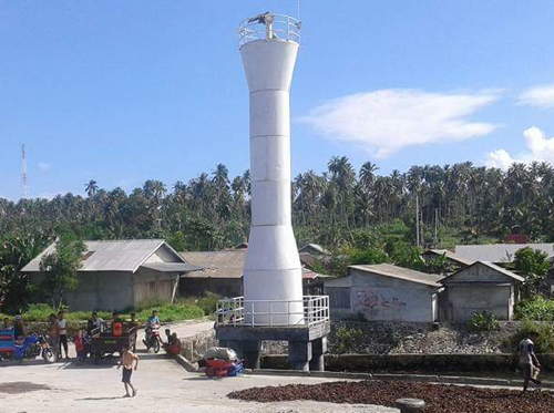
1883 (Dutch). Active; focal plane 119 m (390 ft); white flash every 4 s. 60 m (197 ft) round cast iron tower with lantern and gallery, painted white. Adjoining keeper's houses are occupied by resident keepers. Bahtera Nasution has the 2019 photo seen at the top of this page and Google has a good satellite view. The purpose of this landfall light is to mark the passage between the Batu Islands and the island of Siberut, leading to the mainland port of Padang. Located on an island just off the south tip of Pulau Tanahbala. Accessible only by boat. Site open, tower open by arrangement with the keepers. ARLHS IDO-070; Admiralty Q0842; NGA 23192.
Pulau Simuk
Date unknown. Active; focal plane 43 m (141 ft); one long white flash every 10 s. Approx. 30 m (98 ft) square skeletal tower mounted on a station building. Several additional station buildings. No photo available but Google has a satellite view of the station. Located at a small settlement on Pulau Simuk, an isolated island about 32 km (20 mi) west of Pulau Sigata. Accessible only by boat. Site status unknown. Admiralty Q0838.4.

Sigolong Golong Light, Batu Islands, May 2017
ex-Google Plus photo by Yason Waruwu
Pelabuhan Simuk
Date unknown. Active; focal plane about 14 m (46 ft); white flash every 5 s. Approx. 12 m (39 ft) square skeletal tower. No photo available but Google has an indistinct satellite view. Located at the base of the pier at the Pulau Simuk harbor, on the west coast of the island. Site open, tower closed. Admiralty Q0838.5; NGA 23206.
Pulau Sigata (2)
Around 2018 (station established 1913). Active; focal plane 116 m (381 ft); white light, 2 s on, 1 s off. 35 m (115 ft) octagonal concrete tower with lantern and gallery. Several 1-story coast guard station buildings. Hadirat Gahons has a 2019 closeup photo and Google has a very fuzzy satellite view. The new lighthouse replaced a pyramidal white skeletal tower with lantern and gallery; Bing has a satellite view. Located on a small island of the Batu group, northwest of Tanahmasa. Accessible only by boat. Site status unknown. ARLHS IDO-076; Admiralty Q0838; NGA 23204.
Pulau Pono
Date unknown. Active; focal plane 14 m (46 ft); white flash every 5 s. Approx. 10 m (33 ft) white tower. No photo available but Google has a satellite view. Located on an island about 8 km (5 mi) south of Pulau Tello. Accessible only by boat. Site status unknown. Admiralty Q0838.7; NGA 23209.5.
* Pulau Tello (Pulotello, Pulau Hibao Tello) (2)
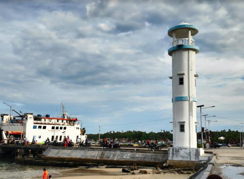
Around 2018. Active; focal plane 16 m (52 ft); white flash every 4 s. Approx. 12 m (39 ft) round cylindrical concrete tower with an open lantern, painted white with blue trim. Teddy Menas has a 2019 photo (also seen at right), Edwinar Wau also has a photo, and Google has a satellite view. Edi Wilson has a sunrise 2017 photo of the earlier lighthouse, a square skeletal tower. Located on the main quay at Pulau Tello, an island off the northwestern end of Tanahmasa. Site open, tower closed. Admiralty Q0839.4; NGA 23208.
Pulau Batumakele Range Front
Date unknown. Active; focal plane 13 m (43 ft); white flash every 3 s. 13 m (43 ft) square skeletal tower on a platform supported by piles. No photo available but Google has a satellite view. The range guides ships in the passage between Pulau Tello and the northwestern end of Tanahmasa. Located north of Pulau Batumakele, opposite Pulau Tello. Accessible only by boat. Site status unknown. Admiralty Q0839.
Pulau Batumakele Range Rear
Date unknown. Active; focal plane 18 m (59 ft); white flash every 5 s. Approx. 13 m (43 ft) square skeletal tower on a platform supported by piles. No photo available but Google has a fuzzy satellite view. Located at the northwest end of Pulau Batumakele. Site status unknown. Admiralty Q0839.1.
 
Pulau Marit
Date unknown. Active; focal plane 15 m (49 ft); white flash every 4 s. 15 m (49 ft) white fiberglass tower mounted on a square platform supported by piles. No photo available but Google has an indistinct satellite view. Located off the east end of Pulau Marit, a small island off the northwestern tip of Tanahmasa. Accessible only by boat. Site open, tower closed. Admiralty F1234; NGA 23202.

Pulau Tello Light, Batu Islands, July 2019
Google Maps photo by Teddy Menas
Tanjung Batubelobang (Pulau Pini)
Date unknown. Active; focal plane 42 m (138 ft); white flash every 8 s. 30 m (98 ft) skeletal tower, painted white. No photo available but Bing has a satellite view. Pulau Pini is a substantial island, about 40 km (25 mi) long, at the northeast corner of the Batu group. Located at the western tip of the island. Site status unknown. ARLHS IDO-241; Admiralty F1235; NGA 23209.
Tanjung Simanusu
Date unknown. Active; focal plane 31 m (102 ft); white flash every 4 s. Approx. 20 m (66 ft) square skeletal tower painted white. No photo available but Bing has an indistinct satellite view. Located on the northeastern corner of Pulau Pini, guiding vessels in the passage between the Batu Islands and the mainland of Sumatra. Site status unknown. Admiralty F1235.5; NGA 23209.2.
Karang Ular
Date unknown. Active; focal plane 15 m (49 ft); white flash every 4 s. 15 m (49 ft) square white skeletal tower mounted on a square platform supported by piles. No photo available but Bing has a satellite view. Located on a reef about 8 km (5 mi) east of Tanjung Simanusu. Accessible only by boat. Site open, tower closed. Admiralty F1237; NGA 23210.

Nias Island Lighthouses

Nias is a large island (more than 5000 km2) about 140 km (88 mi) off the Sumatran coast and 80 km (50 mi) northwest of the Batu group. It has a substantial population, nearly 900,000. The island is accessible by air and by ferries from Sibolga on the mainland of North Sumatra.

South Nias Regency Lighthouses
Pulau Sumabawa
Date unknown. Active; focal plane 33 m (108 ft); white flash every 4 s. 30 m (98 ft) white skeletal tower. No photo available but Google has a satellite view that probably shows the lighthouse. Located on a very small island about 15 km (9 mi) off the southeast coast of Nias. Accessible only by boat. Site status unknown. Admiralty F1257; NGA 23246.
Ujung Sumabawa
Date unknown. Active; focal plane 22 m (72 ft); four white flashes every 17 s. 20 m (66 ft) square skeletal tower painted white. No photo available and the tower has not been found in Google's satellite view of the cape. Located on a promontory about 35 km (22 mi) north of Dalam on the southeast coast of Nias. Site status unknown. Admiralty F1256; NGA 23245.5.
* Teluk Dalam
Date unknown. Active; focal plane 32 m (105 ft); white flash every 3 s. Approx. 29 m (95 ft) square skeletal tower with gallery. Google's 2023 street view is at right, Irma Novianis has a 2020 photo, Juner Bastian has a sunset photo, and Google has an indistinct satellite view. The Admiralty renumbered this light in 2021. Located on the main quay of Teluk Dalam, a port and resort town at the southern tip of Nias. Site open, tower closed. Admiralty F1255.1; NGA 23236.
Tanjung Hele (?)
Date unknown. Active (?); focal plane 168 m (551 ft); white flash every 5 s. 8 m (26 ft) white skeletal tower. No photo available and the tower has not been found in Google's satellite view of the cape. Located on a prominent cape sheltering the south side of Dalam Bay. Admiralty F1255; NGA 23232.
Pantai Tanjung Hele
Date unknown. Active; focal plane about 30 m (98 ft); white light, pattern unknown. Approx. 30 m (98 ft) square white skeletal tower on a platform supported by piles. No photo available but Google has a satellite view. It is possible this light replaces the previous entry, which seems to have disappeared in the forested heights of the cape. Located on the beach at Tanjung Hele. Site open, tower closed. Admiralty F1255.05.
* Teluk Lagundri (Lagundi)
Date unknown. Active; focal plane 13 m (43 ft); white flash every 6 s. 13 m (43 ft) white barbell-shaped tower on a platform supported by piles. Hans Jonathan has photo and Bing has a satellite view. Located just off the beach at Lagundri Beach near the southern tip of Nias. Site open, tower closed. Admiralty F1254.6; NGA 23238.
Tanjung Soahebohu (Soahebeuheu)
Date unknown. Active; focal plane 35 m (115 ft); four white flashes every 18 s. Approx. 30 m (98 ft) skeletal tower, painted white. No photo available but Bing has an indistinct satellite view. Located at the southwestern tip of Nias. Site status unknown. Admiralty F1254.5; NGA 23239.

Teluk Dalam Light, South Nias, August 2023
Google Maps street view

West Nias Regency Lighthouses
Pulau Hinako (Hinaka)
1912. Active; focal plane 54 m (177 ft); white flash every 5 s. 32 m (105 ft) square pyramidal cast iron skeletal tower, painted white. Several coast guard station buildings. No photo available but Google has a satellite view of the station. This lighthouse guides vessels passing Nias to the west. The satellite view suggests that the original lighthouse is still in service. Located on a small island in the Indian Ocean about 10 km (6 mi) off the west coast of Nias. Accessible only by boat. Site status unknown. ARLHS IDO-198; Admiralty F1254; NGA 23240.
* Pelabuhan Pulau Hinako (2)
Date unknown. Active; focal plane about 25 m (82 ft); white light, 2 s on, 4 s off. Approx. 24 m (79 ft) octagonal cylindrical white concrete tower. Iman Halawa has the photo at right, another photo is available, and Google has a satellite view. NGA describes a 6 m (20 ft) mast for this light. Located at the base of the pier in the village on the southeast side of Pulau Hinako. Site open, tower closed. Admiralty F1254.2; NGA 23244.
* [Pelabuhan Sirombu]
Date unknown. Active; focal plane about 12 m (39 ft); white light, pattern unknown. Approx. 9 m (30 ft) white post with gallery. Musliono Adicipta has a photo, Robi Maulana has a view from the sea, and Google has a satellite view. Located at the ferry terminal in Sirombu. Site open, tower closed. Not listed by the Admiralty.
Tanjung Sirombu
Date unknown. Active; focal plane 32 m (105 ft); four white flashes every 18 s. Approx. 25 m (82 ft) square skeletal tower painted white. No photo available but Google has a satellite view. The cape is actually a tombolo: an island connected to the mainland by a narrow isthmus. Located midway on the west coast of Nias. Site probably open, tower closed. Admiralty F1254.4; NGA 23244.2.

Pelabuhan Hinako Light, West Nias, March 2018
Google Maps photo by Iman Halawa

North Nias Regency Lighthouses
Tanjung Sebua
Date unknown. Active; focal plane 21 m (69 ft); white flash every 4 s. 20 m (66 ft) tapered square skeletal tower painted white. No photo available but Bing has a satellite view. Located on a promontory on the northwestern coast of Nias. Site status unknown. Admiralty F1253; NGA 23247.5.
Pulau Wunga (Hulo Wunga)
Date unknown. Active; focal plane 46 m (151 ft); two white flashes evry 10 s. 30 m (98 ft) square white skeletal tower rising from a 2-story coast guard station building. No photo available but Google has a satellite view. The international light lists misspell the name as Hulo Wunga. Located on a small island off the northwest coast of Nias. Accessible only by boat. Site status unknown. Admiralty F1252.5.
Tanjung Toyolawa
Around 2014. Active(?); focal plane about 32 m (105 ft); white light, pattern unknown. Approx. 27 m (89 ft) octagonal concrete tower with lantern and gallery, painted white. A 2020 photo is at right, a 2014 photo is available, Taruna Jaya Zebua has a 2023 closeup, and Google has a satellite view. Located at the northwestern tip of Nias. Site open, and the tower may also be open. This major lighthouse is not listed by the Admiralty; it is possible it was never activated.
Gosong Baohi
Date unknown. Active; focal plane 28 m (92 ft); white flash every 5 s. 25 m (82 ft) cast iron skeletal tower, painted white. No photo available but Google has an indistinct satellite view. This lighthouse guides vessels to the port of Lahewa. Located on an island off the northern coast of Nias. Accessible only by boat. Site status unknown. ARLHS IDO-129; Admiralty F1250; NGA 23260.
Lahewa
Date unknown. Active; focal plane 14 m (46 ft); white flash every 3 s. 14 m (46 ft) white barbell-shaped fiberglass tower. No photo available but Google has a satellite view. Located on the east side of the narrow entrance to the harbor of Lahewa. Accessible only by boat. Site open, tower closed. Admiralty F1252; NGA 23261.
Gosong Uma (Pulau Gosouma)
Date unknown. Active; focal plane 18 m (59 ft); white flash every 5 s. 18 m (59 ft) white skeletal tower on a platform supported by piles. Björn Svensson has a photo and Google has a satellite view. The Admiralty and NGA list the light as Goso Uma. Located at northern tip of a dangerous reef system about 13 km (8 mi) northeast of the Lahewa entrance. Accessible only by boat. Site open, tower closed. Admiralty F1251; NGA 23262.

Tanjung Toyolawa Light, Lahewa, October 2020
photo posted to Facebook by Go Nias Tour
Pulau Sarangbaung
Date unknown. Active; focal plane 55 m (180 ft); two white flashes every 8 s. Approx. 50 m (164 ft) square pyramidal skeletal communications tower. A photo is available and Bing has an indistinct satellite view. NGA misspells the name as Sarangbuang. Located on a small island about 20 km (13 mi) north of the northern tip of Nias. Accessible only by boat. Site status unknown. Admiralty F1259; NGA 23258.

Gunungsitoli City Lighthouses
Tanjung Mbaa (2)
2014 or 2015. Active; focal plane 75 m (246 ft); white flash every 5 s. 21 m (69 ft) octagonal concrete tower with lantern and gallery painted white with blue trim. An aerial photo is available, Nura Sombolinggi has a closeup, Deny Prayatna has a view from the harbor, and Google has a satellite view . The light guides vessels approaching Gunungsitoli, the administrative center of the island, on the northeast coast. NGA lists the original lighthouse, a 21 m (69 ft) cast iron skeletal tower. Located on a promontory about 3 km (2 mi) north of Gunungsitoli. Site status unknown. ARLHS IDO-286; Admiralty F1248; NGA 23248.
* Gunungsitoli (2?)
Date unknown. Active; focal plane about 13 m (43 ft); yellow (?) flash every 3 s. Approx. 11 m (36 ft) octagonal cylindrical white concrete tower. Andy Bona's photo is at right, Iduansyah Imran has a photo, and Google has a distant street view, but the light is not shown in Google's satellite view. NGA lists a "yellow beacon." Located on the waterfront of Gunungsitoli. Site open, tower closed. Admiralty F1248.2; NGA 23256.

Nias Regency Lighthouse
* [Pelabuhan Laut Pulau Nias]
Date unknown (privately maintained?). Active; focal plane about 15 m (49 ft); light characteristics unknown. Approx. 13 m (43 ft) white concrete post with gallery. Rizal Rifai has a 2018 photo and Google has an indistinct satellite view. Located at a commercial terminal at Fowa on the central east coast of Nias. Site open, tower closed. Not listed by the Admiralty.

Gunungsitoli Light, Gunungsitoli, January 2006
ex-Google Plus photo by Andy Bona

Information available on lost lighthouses:

Notable faux lighthouses:

Adjoining pages: North: Western Aceh | East: Northwestern Sumatra | South: Southwestern Sumatra

Return to the Lighthouse Directory index | Ratings key

Posted April 13, 2006. Checked and revised February 27, 2024. Lighthouses: 35. Site copyright 2024 Russ Rowlett and the University of North Carolina at Chapel Hill.