Lighthouses of Indonesia: Northwestern Sumatra

The Republic of Indonesia has been independent since 1945 after having been the Dutch East Indies for more than 350 years. It is a huge country, stretching along both sides of the Equator for more than 46 degrees of longitude (roughly 5100 km or 3200 miles). Comprised of some 17,000 islands (more than 6000 inhabited islands), it has hundreds of major aids to navigation.

Sumatra (Sumatera in the Indonesian spelling) is the world's sixth largest island and the westernmost of the major islands of Indonesia. It is separated from Malaysia to the north by the Malacca Strait, from Borneo to the northeast by the broad Karimata Strait, and from Java to the southeast by the Sunda Strait. Its south coast faces the open Indian Ocean.

Indonesia is divided into 38 provinces (provinsi) and the provinces are subdivided into county units called regencies (kabupaten). Sumatra includes eight of the provinces. This page includes lighthouses of the west coast of North Sumatra Province. Off its west coat North Sumatra also includes the Batu Islands and the large island of Nias; lighthouses of those islands are described on the Nias page. Lighthouses of the east coast of the province are described on the Northeastern Sumatra page.

More than 700 languages are spoken in Indonesia. The official national language, Indonesian (Bahasa Indonesia), was standardized from a form of Malay that served as a lingua franca across the archipelago. In Indonesian a lighthouse is a mercusuar or a menara suar. Tanjung is a cape, ujung is a headland or point of land, bukit is a hill, sungai is a river, kuala or muara is an estuary or river mouth, pulau is an island, karang is a reef, batu is a rock, laut is a sea, selat is a strait, teluk is a bay, pelabuhan is a harbor, and labuhan is a port.

Aids to navigation in Indonesia are operated and maintained by the Directorate of Marine Navigation within the Directorate General of Sea Transportation.

ARLHS numbers are from the ARLHS World List of Lights. Admiralty numbers are from volumes F and Q of the Admiralty List of Lights & Fog Signals. U.S. NGA List numbers are from Publication 112.

General Sources
Indonesian Lighthouses
Historic postcard views from the collection of Michel Forand.
Lighthouses in Indonesia
Photos by various photographers available from Wikimedia; most of the photos are historic.
World of Lighthouses - Indonesia
Photos by various photographers available from Lightphotos.net.
Online List of Lights - Indonesia
Photos by various photographers posted by Alexander Trabas.
Navionics Charts
Navigation chart for Sumatra's west coast.

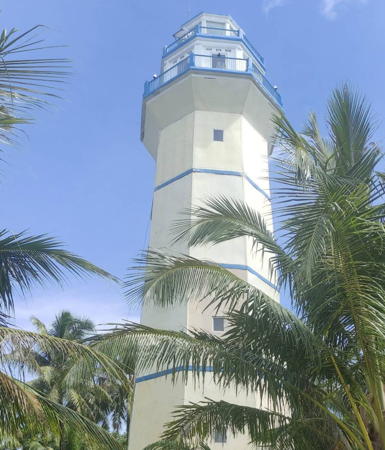
Pulau Karang Light, Andam Dewi, December 2021
Google Maps photo by Hariyadi Putraga

Mentawai Strait Lighthouses

These lighthouses mark uninhabited reefs and islets in a loose chain along the center of the Mentawai Strait between Nias and the mainland of Sumatra.

Pulau Panjang
Date unknown. Active; focal plane 14 m (46 ft); six quick white flashes followed by one long white flash every 15 s. 14 m (46 ft) tower, probably skeletal, upper half painted yellow and lower half black, on a platform supported by piles. No photo available and Google has only a fuzzy satellite view of the area. NGA lists the light as Karang Pandjang. Located off an islet near the south end of the reef system about 40 km (25 mi) east of the southeast coast of Nias. Accessible only by boat. Site open, tower closed. Admiralty F1262.4; NGA 23247.
Karang Willem III
Date unknown. Active; focal plane 12 m (39 ft); two white flashes evry 8 s. 15 m (49 ft) tower, probably skeletal, painted black with one red horizontal band, on a platform supported by piles. No photo available and the light is not seen in Google's satellite view. Willem III was the King of the Netherlands from 1849 to 1890. Located on a reef about 20 km (13 mi) south of Pulau Bintanah. Accessible only by boat. Admiralty F1262.35.
Pulau Bintanah
Date unknown. Active; focal plane 33 m (108 ft); white flash every 5 s. 30 m (98 ft) cast iron skeletal tower, painted white. No photo available but Bing has a satellite view. Located on an island in the center of the Mentawai Strait, midway between Nias and the Sumatra mainland. Accessible only by boat. Site status unknown. ARLHS IDO-112; Admiralty F1262.3; NGA 23267.
Karang Pilades Selatan (South Pylades)
Date unknown. Active; focal plane 16 m (52 ft); white flash every 8 s. 16 m (52 ft) tower, probably skeletal, painted black with one red horizontal band, on a platform supported by piles. No photo available and the light is not seen in Google's satellite view. Located on a reef system in the center of the Mentawai Strait east of the northern point of Nias. Accessible only by boat. Site open, tower closed. Admiralty F1262; NGA 23268.
Pulau Lakota
Date unknown. Active; focal plane 13 m (43 ft); white flash every 6 s. 13 m (43 ft) white tower, probably skeletal, on a platform supported by piles. No photo available and the light is not seen in Google's satellite view. Located off an island near the north end of the reef system. Accessible only by boat. Site open, tower closed. Admiralty F1260; NGA 23268.5.

Sumatra West Coast Lighthouses

Mandailing Natal Regency Lighthouses
Pulau Temang (2?)
Date unknown (station established 1913). Active; focal plane 65 m (213 ft); white light, 3 s on, 6 s off. 22 m (72 ft) octagonal white concrete tower with lantern and gallery.Faisal Hamidi has a 2020 drone view (a portion is seen at right), Faisal Hamidi also has a drone view, Rio Febrian has a 2021 closeup photo, and Bing has a satellite view of the station. Several coast guard station buildings.This lighthouse replaced a skeletal tower. Located at the west end of an island just off the mainland coast near Batahan. Accessible only by boat. Site status unknown. ARLHS IDO-252; Admiralty F1238; NGA 23220.

Pulau Temang Light, Batahan, November 2020
Google Maps photo by Faisal Hamidi
Pulau Temang Laut Reef (Sea Reef)
Date unknown. Active; focal plane 17 m (56 ft); red flash every 5 s. 17 m (56 ft) red skeletal tower on a platform supported by piles. No photo available but Bing has an indistinct satellite view. the light was added to guide ships to the new Batahan Port. Located off the southeast point of Pulau Temang. Accessible only by boat. Site open, tower closed. Admiralty F1239.
Batahan Port
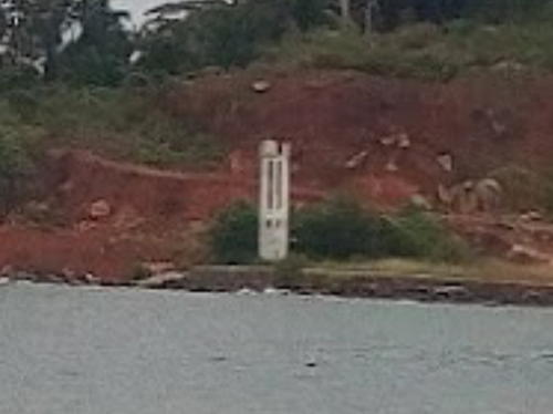
Date unknown. Active; focal plane 12 m (39 ft); white flash every 7 s. 11 m (36 ft) white concrete skeletal tower. Darmawan Syahputra has the distant view seen at right and Google has a very fuzzy satellite view. This is a new port on the mainland opposite Pulau Temang. Located at the north edge of the port. Site status unknown. Admiralty F1240.
Natal
Date unknown. Active; focal plane 15 m (49 ft); white flash every 3 s. 15 m (49 ft) square cylindrical white skeletal tower. No photo available but Google has a satellite view. Located in the estuary entrance at Natal, apparently marking the north side of a very narrow channel. Accessible only by boat. Site status unknown. Admiralty F1241; NGA 23224.
Karang Bayang
Date unknown. Active; focal plane 13 m (43 ft); white flash every 5 s. 13 m (43 ft) square skeletal tower, painted black with a red horizontal band, on a platform supported by piles. No photo available and the light is not shown in Google's satellite view. Located on a reef about 15 km (9 mi) west northwest of Natal. Accessible only by boat. Site open, tower closed. Admiralty F1242; NGA 23224.5.
Sikarakara
Date unknown. Active; focal plane 13 m (43 ft); white flash every 5 s. 13 m (43 ft) square white skeletal tower on a platform supported by piles. Arianto Nasution has a very distant view from the Sikarakara Beach (the tower is just the right of the trees in the water on the left) and Google has a satellite view. Located off the south side of Ujung Sikarakara. Accessible only by boat. Site open, tower closed. Admiralty F1242.5; NGA 23225.

Pelabuhan Batahan Light, Batahan, April 2018
Google Maps photo by Darmawan Syahputra
Pulau Labu (Pulau Sidakah)
Date unknown. Active; focal plane 65 m (213 ft); white flash every 5 s. 15 m (49 ft) skeletal tower, painted white. No photo available but Google has a satellite view. Located at the west end of an island just off the mainland coast about 45 km (28 mi) north of Batahan. Accessible only by boat. Site status unknown. ARLHS IDO-211; Admiralty F1244; NGA 23228.
Pulau Ilir
Date unknown. Active; focal plane 94 m (308 ft); white flash every 9 s. Approx. 35 m (115 ft) square skeletal tower with gallery, painted white. Several coast guard station buildings. No photo available but Google has a satellite view of the station. Located on a small island about 2 km (1.25 mi) offshore and 60 km (37 mi) south of Sibolga. Accessible only by boat. Site status unknown. ARLHS IDO-200; Admiralty F1245; NGA 23271.

Central Tapanuli Regency (Sibolga Bay) Lighthouses
Pulau Labulabu Kecil (Labu Labu Kecil)
Date unknown. Active; focal plane 57 m (187 ft); two white flashes every 7 s. 40 m (131 ft) skeletal tower, painted white. No photo available but Bing has a satellite view. Located on a small island on the west side of the southern entrance to the bay of Sibolga. Accessible only by boat. Site status unknown. ARLHS IDO-152; Admiralty F1262.5; NGA 23269.
Pulau Mursala (Mansalar, Musala)
Date unknown. Active; focal plane 35 m (115 ft); white flash every 5 s. Approx. 20 m (66 ft ) square skeletal tower with gallery, painted white. No photo available but Bing has a satellite view. NGA lists this light as "Pulau Mansalar." Mursala Island is best known for a waterfall that cascades directly into the sea. Located on a northwest end of the island, marking the northern entrance to the bay of Sibolga. Accessible only by boat. Site status unknown. Admiralty F1265; NGA 23259.
Pulau Poncang
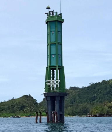
Date unknown. Active; focal plane 11 m (36 ft); green flash every 2 s. 11 m (36 ft) octagonal cylindrical green tower, lowest portion skeletal, on a platform supported by piles. Boas Simamora's 2022 photo is at right, Dikky Mahdani has a distant view, and Google has a satellite view. Located on the south side of the southern entrance to Sibolga Bay. Accessible only by boat. Site open, tower closed. Admiralty F1263.3; NGA 23276.

Pulau Poncang Light, Sibolga, May 2022
Google Maps photo by Boas Simamora
Aik Habil South
Date unknown. Active; focal plane 10 m (33 ft); green flash every 5 s. 10 m (33 ft) green post mounted a skeletal tower on a platform supported by pyramdial piles. Mia Suwarno has a 2023 photo and Google has a fuzzy satellite view. Located on a shoal at the south side of the entrance to Sibolga's harbor. Should be easy to see from shore. Site open, tower closed. Admiralty F1263.5; NGA 23272.
Aik Habil North (Sarudut)
Date unknown. Active; focal plane 10 m (33 ft); red flash every 5 s. 10 m (33 ft) red post mounted a skeletal tower on a platform supported by pyramdial piles. This light is seen in the left distance in Mia Suwarno's 2023 photo and Google has a fuzzy satellite view. Located at the edge of a large shoal area on the north side of the entrance to Sibolga's harbor. Should be easy to see from shore. Site open, tower closed. Admiralty F1264.5; NGA 23280.
Pulau Pocan Kecil (Pocan Ketak)
Date unknown. Active; focal plane 12 m (39 ft); three quick white flashes every 12 s. 12 m (39 ft) square pyramidal skeletal tower, painted black with one yellow horizontal band and mounted on a square platform supported by piles. Ezra Edi Prasodjo has a distant 2022 view and Google has a satellite view. Located on the east side of an island in the middle of Sibolga Bay. Accessible only by boat. Site open, tower closed. Admiralty F1263.2; NGA 23285.
* Sibolga Fishing Port
Date unknown. Active; focal plane about 18 m (59 ft); white light, characteristic unknown. Approx. 15 m (49 ft) square pyramidal skeletal tower, painted white. The light is at the left of Patpat Gulipat's photo of the waterfront and Google has a satellite view. Located at the fishing port on the south side of Sibolga. Site open, tower closed. Admiralty F1264.1.
* Teluk Sibolga
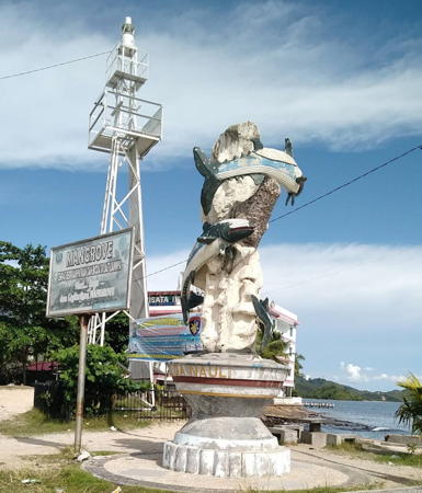
Date unknown. Active; focal plane 13 m (43 ft); white flash every 5 s. 12 m (39 ft) square pyramidal skeletal tower, painted white; the front face of the tower is covered with a white daymark. Rahmad Loebiz has the photo at right, A.L. Saraghi has a photo, Randhi Prima has a drone view, and Google has a distant street view and an indistinct satellite view. Located on the waterfront in the northern part of Sibolga. Site open, tower closed. Admiralty F1264; NGA 23288.
Ujung Karang (Gosong Ular)
Date unknown. Active; focal plane 41 m (134 ft); three white flashes every 17 s. 40 m (131 ft) skeletal tower, painted white. Four 1-story coast guard station buildings. No photo available but Google has a satellite view of the station. Located on a peninsula sheltering the west side of the bay of Sibolga. Site status unknown. ARLHS IDO-349; Admiralty F1263; NGA 23284.
Pulau Karang (Reef Island) (2)
2021(?). Active; focal plane about 33 m (108 ft); white light, 1.5 s on, 3.5 s off. Approx. 30 m (98 ft) octagonal concrete tower with lantern and gallery, painted white with blue trim. Hariyadi Putraga has the December 2021 photo seen at the top of this page and Google has a fuzzy satellite view. NGA lists the 11 m (36 ft) white skeletal tower seen in Bing's fuzzy satellite view. Located at the southwest end of a small island off the resort village of Barus. Accessible only by boat. Site status unknown. Admiralty F1265.5; NGA 23290.
Ujung Silabi
Date unknown. Active; focal plane 11 m (36 ft); white light, 2 s on, 8 s off. 11 m (36 ft) white fiberglass tower mounted on a square platform supported by piles. No photo available but Bing has a satellite view. Located just off a promontory near the northern border of North Sumatra Province. Accessible only by boat. Site status unknown. Admiralty F1266.3; NGA 23289.

Sibolga Light, Central Tapanuli, October 2017
ex-Google Plus photo by Rahmad Loebiz

Information available on lost lighthouses:

Notable faux lighthouses:

Adjoining pages: North: Western Aceh | South: Southwestern Sumatra | West: Nias

Return to the Lighthouse Directory index | Ratings key

Posted April 13, 2006. Checked and revised March 2, 2024. Lighthouses: 24. Site copyright 2024 Russ Rowlett and the University of North Carolina at Chapel Hill.