Lighthouses of India: Karnataka and Goa

The Republic of India (Bhārat in Hindi) is the seventh largest country and second most populous country in the world. It occupies a subcontinent of Asia that projects southward into the North Indian Ocean, separating the Bay of Bengal on the east from the Arabian Sea on the west. Before 1947 it was a patchwork of regions governed as British colonies and semi-independent princely states under British supervision. In 1947 this British Raj was partitioned into the independent states of India and Pakistan. Several French and Portuguese colonies embedded in the territory of India were absorbed in 1950 and 1961, respectively.

India is a federal union of 28 states and 8 union territories. This page lists lighthouses of the central western coast of India in the states of Karnataka and Goa. The coast of these states is the northern half of the coast known historically as the Malabar Coast. For many centuries it was visited by Arab and sometimes Chinese traders, and it was the first Indian coast encountered by European explorers. In general, the coastline is low and sandy, but the land rises quickly behind the beaches to the mountains called the Western Ghats.

The major lighthouses of India are staffed and by tradition most of them are open to visitors for a short time during the late afternoon every day; inquire locally concerning the times.

Hindi and English are official languages in India, with English serving as a lingua franca for the entire nation. The Indian Constitution recognizes another 21 languages, called scheduled languages, and each of the coastal states has its own scheduled language in official use. In Kannada, the official language of Karnataka, the word for a lighthouse is transliterated from English as laiṭ'haus (ಲೈಟ್ಹೌಸ್); dvipa is an island, nadi is a river, and bandaru is a harbor. In Konkani, the official language of Goa, the word for a lighthouse is bautokato.

Lighthouses and aids to navigation in India are administered by the Directorate General of Lighthouses and Lightships (DGLL), an agency of the Ministry of Shipping. Coastal lighthouses of Karnataka and Goa are maintained by the Goa Directorate. Harbor lighthouses are maintained by the respective port authorities.

ARLHS numbers are from the ARLHS World List of Lights. Admiralty numbers are from volume F of the Admiralty List of Lights & Fog Signals. U.S. NGA List numbers are from Publication 112.

General Sources
Aids to Navigation: Goa Region
Lighthouse information from DGLL, including photos for most of the lighthouses.
Lighthouses in India
Photos by various photographers available from Wikimedia.
List of Lighthouses in India
Index to Wikipedia articles.
World of Lighthouses - India
Photos by various photographers available from Lightphotos.net.
Online List of Lights - India
Photos by various photographers posted by Alexander Trabas. Most of the photos from this area are by Douglas Cameron.
Indian Lighthouses
Historic postcard images posted by Michel Forand.
Leuchttürme Asiens auf historischen Postkarten
Historic postcard images posted by Klaus Huelse.
Navionics Charts
Navigation chart for the Indian coast.
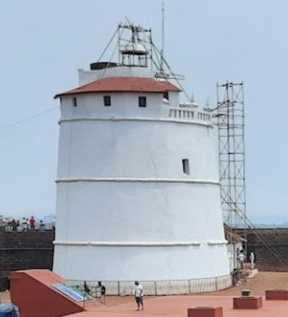
Fort Aguada Light, Candolim, Goa, April 2022
Google Maps photo by Sai Avinash

Lighthouses of Karnataka

Dakshina Kannada District (Mangalore Area) Lighthouses
Mangalore (officially Mangaluru), the major port of Karnataka, is only 20 km (13 mi) north of the Kerala border. The port is an important container terminal and is known for export of coffee and cashews.
* Mangalore Harbour (Aga, Bolar, Hoigebazaar) (2)
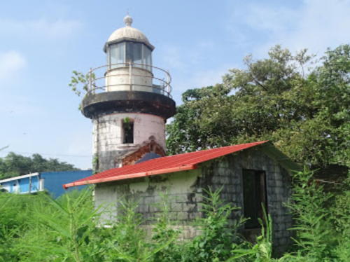
1903 (station established 1843). Inactive since 2013 but listed with focal plane 10 m (33 ft); white flash every 3 s. 11 m (36 ft) round cylindrical masonry tower with lantern and gallery, painted with black and white horizontal bands. A district government photo is at right, Shashwath Kini has a 2018 photo, Vishwas Rao also has a 2018 photo, a 2021 closeup is available, and Google has a 2022 street view and a satellite view. Clearly endangered. Previously maintained by local port authorities, this was probably the last lighthouse in the world to be lit using acetylene gas (AGA) cylinders, a century-old technology. In 2015 the Deccan Herald reported on efforts to put it under DGLL's control in order to get it back in operation. There's no indication that this effort has succeeded. Located on the grounds of the Mangalore College of Fisheries adjacent to Mangalore's traditional harbor. Site open, tower closed. ARLHS IND-100; Admiralty F0668; NGA 27684.
* Mangalore
1870. Inactive. 20 m (66 ft) masonry tower carrying a large square structure, mounted on a square base. A 1-story stone keeper's house is in use as a public library. Ramesh Bhat Manjunath has a 2022 photo, Godwin Castelino has a photo, Wikimedia has a good photo, Geetha Pai has a 2018 photo, Sanjay Kamath has a 2017 street view, Huelse has a historic postcard view, and Google has a satellite view. We need more information on the history of this interesting tower. An article in Wikipedia says the tower was built as a watchtower by Sultan Haidar Ali, the de facto ruler of the Mysore kingdom from about 1763 until his death in 1782; if so, the tower dates from that era. The British annexed Mangalore in 1799. Findlay's 1879 light list gives 1870 as the establishment of a modern light; from its hilltop location the light had a focal plane of 73 m (240 ft). There exist historic images (third and fourth rows on the page) that show something like a conventional lantern room atop the tower; one image is dated 1905. The 1904 world light list does not include the light. Located in Tagore Park, atop Light House Hill above the business district of Mangalore. Site open, tower closed. ARLHS IND-171.

Mangalore Harbour Light, Mangalore, August 2021
Google Maps photo by Udupi & Dakshina Kannada District
New Mangalore Harbor Range Front
Date unknown. Active; focal plane 17 m (56 ft); quick-flashing white light. Approx. 15 m (49 ft) square skeletal tower atop a square cylindrical white concrete tower. Trabas has Cameron's photo and Google has a satellite view. Located on the waterfront of Mangalore's modern, artficially dredged harbor, about 7 km (4.5 mi) north of the traditional harbor. Site and tower closed. Operator: New Mangalore Port Authority. Admiralty F0666; NGA 27688.
New Mangalore Harbor Range Middle
2009 (?). Active; focal plane 24 m (79 ft); white flash every 4 s. 24 m (79 ft) square concrete tower, painted with red and white horizontal bands and topped by a square skeletal tower. Trabas has Cameron's photo and Google has an unattributed closeup photo and a satellite view. Located on the west side of national highway 17 at Mangalore New Port. Site probably closed, but the tower is easily seen from the road. Operator: New Mangalore Port Authority. Admiralty F0666.05.
New Mangalore Harbor Range Rear
Date unknown. Active; focal plane 27 m (89 ft); white light occulting once every 10 s. Approx. 27 m (89 ft) square skeletal tower painted with red and white horizontal bands Trabas has Cameron's photo showing the rear light behind the middle light and Google has a street view and a satellite view. Located about 200 m (220 yd) east of the middle light. Site probably closed, but the tower is easily seen from the road. Operator: New Mangalore Port Authority. Admiralty F0666.1; NGA 27692.
*** Suratkal (Suratkal Point)
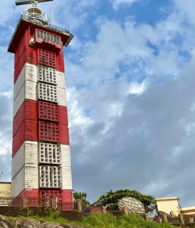
1972. Active; focal plane 44 m (144 ft); white flash every 10 s. 36 m (118 ft) square cylindrical concrete tower with lantern and gallery, painted with red and white horizontal bands. 2-story keeper's house adjacent or attached to the lighthouse. A photo is at right, a 2021 photo and another good photo are available, Raghavendra Joshi has a 2018 photo, Wikimedia has a photo, P. Bachodi has a distant photo, Sandeep Nayak has a beach view, and Google has a satellite view. Standing by a very popular beach, this lighthouse functions as the landfall light for Mangalore. In 2020 DGLL approved plans to renovate the lighthouse as a tourist attraction. Located off the beach about 8 km (5 mi) north of Suratkal and 18 km (11 mi) north of Mangalore. Site open, tower open daily. . ARLHS IND-114; Admiralty F0660; NGA 27700.

Suratkal Light, Suratkal, September 2021
Google Maps photo by Preetham Kb

Udupi District Lighthouses
*** Kaup (Kap, Kapu, Udupi, Udipi)
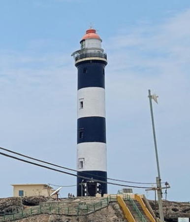
1901. Active; focal plane 43 m (141 ft); three white flashes every 20 s. 27 m (89 ft) round masonry tower with lantern and gallery, painted with black and white horizontal bands; lantern dome painted red. Vignesh Poojary's photo is at right, Kishan Kusagur has a 2022 closeup, Nishant Nadar has a 2020 photo, Nagaraj V. Gowda has a closeup, Anita Bora has a 2005 photo, Huelse has a historic postcard view, Krishna Acharya has a beach view, and Google has a satellite view. This is easily the best known lighthouse of Karnataka. In December 2021 district officials announced plans for visitor improvements including a paved path and viewing platform. Located on a low but rocky promontory interrupting a lengthy beach about 16 km (10 mi) south of Udupi. Site open, tower open daily in late afternoons. . ARLHS IND-091; Admiralty F0658; NGA 27704.
Malpe (St. Mary's Island) (1)
1901. Inactive since 1973. 4.5 m (15 ft) round cast iron lantern, painted red. Lantern dome is gray metallic. Located beside the modern lighthouse.
Malpe (St. Mary's Island) (2)
1973 (station established 1901). Active; focal plane 29 m (95 ft); white flash every 3 s. Approx. 12 m (39 ft) square cylindical masonry tower with lantern and gallery, painted white. Two 1-story keeper's houses. A photo showing both lighthouses (1/5 the way down the page) and a view from the sea are available and Google has a satellite view. Jayalal Udupi has a pier view of the island in which the tower can just be seen. Located atop an island southwest of the entrance to the harbor of Malpe. Accessible only by boat. Site status unknown. ARLHS IND-098; Admiralty F0655; NGA 27708.
*** Kundapura (Coondapoor, Kodi) (2)
2009. Active; focal plane 35 m (115 ft); two white flashes every 10 s. 32 m (105 ft) round cylindrical concrete tower with lantern and gallery, painted with red and white horizontal bands. Sadanand Suvarna also has a photo, Aditha Bhat has a 2018 photo, Manish Mogaveer has a 2022 closeup, another photo is available (1/5 the way down the page), Anudeep Hegde has a street view, and Google has a street view and a satellite view. The light was formerly on a 40 m (131 ft) "mast" (probably a communications tower). Located on the beachfront about 1.2 km (3/4 mi) south of the estuary entrance at Kundapura. Site open, tower open daily in late afternoons. Admiralty F0652; NGA 27712.
* Tippu Sultan Gudda (Gangolli, Ganguli)
Date unknown. Active; focal plane 30 m (98 ft); two white flashes every 10 s. 9 m (30 ft) hexagonal cylindrical concrete tower with lantern and gallery centered on a round 2-story base. Entire lighthouse painted with black and white horizontal bands. Srinivasan Arumugam has a 2018 closeup photo, Sharath Kharvi has a 2020 closeup photo, Wikimapia has photos, a distant view is available, Devdas Kharvi has a 2020 street view, and Google has a 2023 street view and an indistinct satellite view. The lighthouse honors Tipu (or Tippu) Sultan, the ruler of Mysore during the late 18th century. Located on the beachfront about 4 km (2.5 mi) north of the estuary entrance at Kundapura. Site open, tower closed. Operator: Karnataka Ports. Admiralty F0651; NGA 27716.

Kaup Light, Udipi, April 2021
Google Maps photo by Vignesh Poojary

Uttara Kannada District Lighthouses
*** Bhatkal (3)
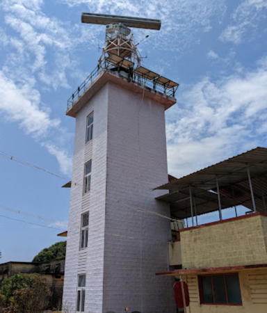
1959 (station established 1891). Active; focal plane 56 m (184 ft); two white flashes every 20 s. 14 m (46 ft) square cylindrical masonry tower with lantern and gallery, painted white. An older DGLL photo (no longer online) showed the lighthouse painted with red and white horizontal bands, but Suruchi Dumpawar's October 2007 photo shows it all white. Abhishek Srivastava's 2023 photo is at right, Parheez Gimi has a 2017 photo, and Google has a satellite view. The original stone post light was replaced by a masonry tower in 1936. Located on a promontory on the west side of the entrance to the Bhatkal River at Bhatkal. Site open, tower open daily. . ARLHS IND-077; Admiralty F0648; NGA 27724.
Honavar Port
Date unknown. Inactive. Approx. 8 m (26 ft) round tower. Shashank Bhat has a photo, Anoop Thakur also has a photo, Raghunandan Pai has a street view, and Google has a satellite view. The light probably became redundant when a bridge was completed over the Sharavati River. Located off the former ferry port on Honnavar. Easily seen from shore or from the bridge. Site open, tower closed.
Honavar (Honnavar) (2?)
Date unknown. Inactive since 2009. Approx. 24 m (79 ft) square skeletal tower painted with red and white horizontal bands. A 2005 photo is available, the tower is at the extreme right edge of Jitender Kumar's photo, and Raghunandan Pai has a street view but the tower is not conspicuous in Google's satellite view. This light was built by the Karnataka Port Department; DGLL took ownership in 2007. NGA formerly listed a light on a mast at Honavar. Located below the modern lighthouse. Site status unknown.
*** Honavar (Honnavar) (3?)
2009 (station establishment date unknown). Active; focal plane 41 m (135 ft); white flash every 15 s. 24 m (79 ft) octagonal cylindrical tower with lantern and gallery, painted with red and white horizontal bands. The top of the tower is surrounded by an octagonal observation room. Ajit Naik Kharwa has a 2020 photo, Mayur Naik has a 2021 photo, Shashank Venugopal has a 2018 closeup photo, Raghunandan Pai has a distant street view from the Sharavathi River Bridge and Google has a satellite view. The lighthouse is built on the grounds of a large hospital. Located on a hill above the Sharavathi estuary, which forms the harbor of Honavar, near the north end of the bridge over the estuary. Site open, tower open daily, at least to the observation room. . Admiralty F0644; NGA 27732.

Bhatkal Light, Bhatkal, May 2023
Google Maps photo by Abhishek Srivastava
* [Kumta Point (Cumta, Vannalli) (1)]
Date unknown (station established 1855). This was originally a 20 m (66 ft) round stone tower adjacent or attached to a stone keeper's house. The buildings are in ruins. Amit Walke has a photo, Kavana Sankalana has a drone view, Suraj Naik has a 2017 street view, and Google has a satellite view. The lighthouse was replaced in 1888 by an "iron tubular mast." More recently there was a light in a 3.5 m (10 ft) lantern, described by NGA as a "round white hut"; this light has been inactive since 2008 and the lantern has probably been removed. The area is now a park and benches provide a fine view of the sea. Located atop a bluff at Kumta, about 20 km (12.5 mi) north of Honnavar. Site open, tower closed. ex-Admiralty F0642; ex-NGA 27740.
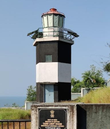
Tadri (3)
2009 (station established 1891). Active; focal plane 38 m (125 ft); three white flashes every 10 s. Approx.10 m (33 ft) hexagonal cylindrical concrete tower with lantern and gallery, painted with black and white horizontal bands; lantern dome is red. A 2022 photo is at right, Dheeraj Paisa has a 2021 photo, a 2018 photo is available, and Google has a satellite view and a closeup street view. The original light was on a mast; it was replaced by an 8 m (26 ft) hexagonal stone tower. Accoridng to DGLL that light was built by the Karnataka Port Department but had been inactive for a long time. The Admiralty finally removed the former light from its list in 2008, but the location was then on a DGLL list of sites scheduled to receive new lighthouses. In 2009 the Indian Navy reported the light restored; although the description was unchanged, the new lighthouse appears to be taller. The light appears to be accessible by a dirt road. Located atop a promontory on the northwest side of the entrance to the harbor of Tadri. Site open, tower status unknown. Admiralty F0638; NGA 27744.
Belekeri (Kukra Island) (2?)
1976. Active; focal plane 66 m (217 ft); three white flashes every 10 s. Approx. 10 m (33 ft) sqaure tower painted with black and white horizontal bands. DGLL has a photo and Google has an indistinct satellite view. Rushikesh Bongarde has a 2022 closeup photo of a concrete pillar that probably carried an earlier light. In 2016 DGLL called for bids on a project of "improvements" at this lighthouse. Located on an island in the entrance to the bay of Belekeri. Accessible only by boat. Site status unknown. Admiralty F0637; NGA 27748.

Tadri Light, Tadri, October 2022
Google Maps photo by SreeRag
Kwada Island
Date unknown. Active; focal plane 13 m (43 ft); red flash every 5 s. 4 m (13 ft) square masonry tower painted red. No photo available but Google has a satellite view. NGA describes the light as green, but this appears to be an error. Located on a very large rock on the east side of the entrance to Karwar Bay. Accessible only by boat. Site status unknown. Operator: Karnataka Ports. Admiralty F0636.9; NGA 27752.6.
Karwar Harbour Range Front
Date unknown. Active; focal plane 18 m (59 ft); quick-flashing white light. 10 m (33 ft) triangular cylindrical skeletal tower painted with red and white horizontal bands. No photo available but Google has a satellite view. This is the entrance range for Karwar Bay. Karwar has a fine naturally protected harbor; it supports both a commercial port and a major Indian Navy base. Located on heights at the west end of the harbor. Site and tower probably closed (the location appears to be on the naval base). Operator: Karnataka Ports. Admiralty F0636.6; NGA 27752.3.
Karwar Harbour Range Rear
Date unknown. Active; focal plane 32 m (105 ft); white flash every 5 s. 22 m (72 ft) triangular cylindrical skeletal tower painted with red and white horizontal bands. No photo available but Google has a satellite view. Located on heights at the west end of the harbor, 420 m (1/4 mi) due north of the front light. Site and tower probably closed (the location appears to be on the naval base). Operator: Karnataka Ports. Admiralty F0636.7; NGA 27752.4.
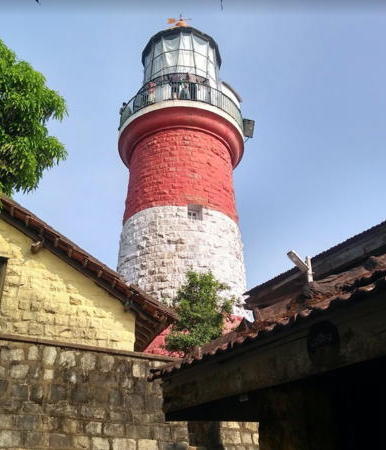
Oyster Rocks
1864. Active; focal plane 63 m (207 ft); white flash every 10 s. 19 m (62 ft) round masonry tower with lantern and gallery, painted red with one white horizontal band; lantern painted white with a red dome. 2nd order Fresnel lens. Sachin Kuvalekar's photo is at right, Nitya Juvekar has a 2018 closeup photo, a 2022 closeup is available, Kaushik Saikia has a distant view at dusk, and Google has a satellite view. This is the oldest lighthouse of Karnataka, built by the British to support their new outpost at Karwar following the Indian Mutiny uprising of 1857. The Oyster Rocks are the westernmost of several reefs and islets protecting the harbor of Karwar. Located about 8 km (5 mi) west southwest of the Karwar waterfront. Accessible only by boat. Site open, many visitors have found the tower open. ARLHS IND-105; Admiralty F0634; NGA 27756.
 

Oyster Rocks Light, Karwar, November 2018
Google Maps photo by Sachin Kuvalekar
 

Lighthouses of Goa

Goa, India's smallest state by area, was the principal territory of the former Portuguese India. It remained under Portuguese control from the early 16th century until it was captured by Indian troops in 1961. In 1987 it became the 25th state of the Indian union.

South Goa District Lighthouses
[Cabo da Rama]
1890. A 1904 light list includes a light with a focal plane of 62 m (203 ft). Nothing remains of the light tower but Vinay Raut has a street view of foundation ruins that must be of the light station. Google's satellite view identifies the ruins as "Canon tower." Cabo da Rama is a prominent headland at Canacona near the southern border of Goa. Site open.
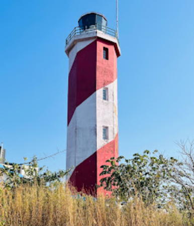
** Betul (Cape Rama) (2?)
2015 (station established 1890). Active; focal plane 88 m (289 ft); white flash every 15 s. Approx. 21 m (69 ft) octagonal cylindrical concrete tower with lantern and gallery, painted with red and white spiral bands. A 2022 photo is at right, Bikash Pradhan has a 2016 photo, Conroy Rodrigues has a second photo, Viresh Vazirani has a gallery view from atop the tower, Ashwin Sekhar has a street view, and Google has a satellite view. Located atop a steep hill behind Betul Beach southwest of Margao. Site open, tower open in late afternoons daily. . Admiralty F0631; NGA 27758.
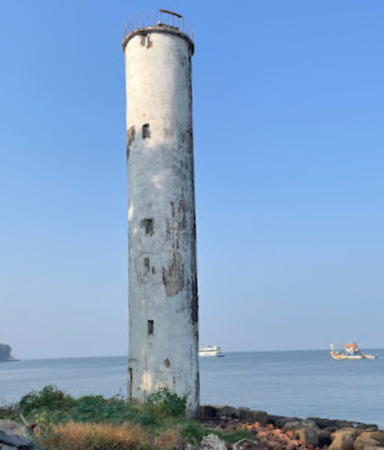
St. George Island (Ilha de São Jorge, Grand Island) (2)
1977 (station established 1956). Active; focal plane 93 m (305 ft); four flashes every 20 s, white or red depending on direction. 16 m (52 ft) slender round cylindrical concrete tower with gallery and an external stairway spiraling around the tower. Lighthouse painted with black and white horizontal bands. A DGLL photo is available, Gregorio Cabral has a view from the sea and Google has an indistinct satellite view. The original light was on a skeletal tower. The Ilha de São Jorge (St. George Island) is now called Grand Island. Located on an island about 8 km (5 mi) south southwest of Marmagão. Accessible only by boat. Site and tower closed. ARLHS IND-112; Admiralty F0628; NGA 27768.
* Mormugao (Mormugão) Breakwater North Head (2)
Date unknown (station established 1902). Active; focal plane 26 m (85 ft); one long (1.5 s) flash every 5 s, white, red or green depending on direction. 23 m (75 ft) 2-stage tower: the lower half is a hexagonal concrete or masonry tower painted all white; the upper half is an hourglass-shaped fiberglass (?) tower painted with red and white horizontal bands. Trabas has Cameron's closeup photo, Chetan Gouda has a 2019 photo, Innayat Ahammad has a 2018 photo, Jayprakash Ambati has a photo, and Google has a satellite view. Forand has a historic postcard view of the original tower. Located at the north end of the breakwater at Mormugao; apparently accessible by walking the breakwater, but there should also be a good view from the ferry between Panaji and Marmagao. Site open, tower closed. Operator: Mormugao Port Authority. ARLHS IND-101; Admiralty F0622; NGA 27760.
* Mormugao (Mormugão) Breakwater East Head (2)
Date unknown. Active; focal plane 8 m (26 ft); white flash every 10 s. 6 m (20 ft) round hourglass-shaped tower painted black with one white horizontal band. Innayat Ahammad has a view along the pier and Google has a satellite view. Located at the east end of the breakwater at Marmagao; apparently accessible by walking the pier. Site open, tower closed. Operator: Mormugao Port Authority. Admiralty F0622.2; NGA 27764.

Betul Light, Margao, December 2022
Google Maps photo by Suneita
* Ilha São Jacinto (Range Rear)
1900. Inactive for many years; charted as a landmark. Approx. 12 m (39 ft) round stone tower with a round lantern structure. Jason Bourne has a 2008 photo, Roger Rebelo has a 2012 closeup, and Bing has a satellite view. This abandoned lighthouse is clearly endangered. It was built as the rear light of an entrance range. Located in dense forest on São Jacinto Island, just off the south side of Marmagao Bay. The island is accessible by a bridge and presumably the lighthouse is accessible by a hiking trail; local guidance may be needed. Site open, tower closed.

North Goa District Lighthouses
* Tejo Range Rear
Date unknown. Active; focal plane 14 m (46 ft); continuous red light. 12 m (39 ft) 3-stage tower with a square base, a hexagonal central section, and a skeletal mast at the top; lighthouse painted with black and white horizontal bands. Google has a street view and a fuzzy satellite view. This is an outbound range guiding vessels leaving Panaji, the principal port of Goa. Located in front of a government youth hostel on the south side of the entrance to the Mandovi River. Site open, tower closed. Operator: Panaji Port Authority. Admiralty F0613.1; NGA 27792.
* Tejo Range Front
Date unknown. Active; focal plane 11 m (36 ft); quick-flashing red light. 10 m (33 ft) 2-stage tower with a square base topped by a square cylindrical concrete skeletal tower; lighthouse painted with black and white horizontal bands. A spiral stairway reaches the gallery. Rama Kant Vishwakarma has a 2019 photo, Vishwajeet Vidyarthee has a 2017 photo, Bhadresh Savaliya has a street view, and Google has a satellite view. Located 90 m (295 ft) north of the rear light. Site open, tower closed. Operator: Panaji Port Authority. Admiralty F0613; NGA 27788.
* Panaji Range Front (Campal, Kala Academy) (2)
1981 (station establishement date unknown). Active; focal plane 23 m (75 ft); white flash every 3 s. 22 m (72 ft) round cylindrical concrete or masonry tower, painted white. A 2022 photo is at right, Aparna Balasubramanian has a 2010 photo, Shubham Karpe has a 2019 closeup, Wikimedia has Amol.Gaitonde's 2008 photo, Girish Kamath has a 2016 street view, and Google has a satellite view. This is the front light of the entrance range for Panaji. The lighthouse is endangered by erosion of the riverbank and in December 2016 it was announced that it would be rebuilt. However, Sahil Shirodkar's July 2018 photo shows that this had not yet occurred and a 2023 photo shows the old tower still standing. Located on the south bank of the Mandovi River in front of the Kala Academy. Site probably open, tower closed. Operator: Panaji Port Authority. ARLHS IND-106; Admiralty F0610; NGA 27780.
Panaji Range Rear (Penha di Frans)
Date unknown. Active; focal plane 56 m (184 ft); white flash every 3 s. 11 m (36 ft) square pyramidal skeletal tower centered on a square concrete base. The tower carries a triangular daymark painted with red and white horizontal bands. Trabas has Cameron's photo and Google has an indistinct satellite view and a distant street view. Located on a hill on the north side of the Mandovi River just west of the Mandovi Bridge, about 1.9 km (1.2 mi) northeast of the front light. Site status unknown. Operator: Panaji Port Authority. ARLHS IND-107; Admiralty F0610.1; NGA 27784.

Range Front Light, Panaji, Goa, November 2022
Google Maps photo by Short Notes
* Reis-Magos (Raaj-Magus)
Date unknown. Active; focal plane 13 m (43 ft); green flash every 1.5 s. 12 m (39 ft) round white stone tower. Masood Mujawar has 2015 street view, Suraj Singh has a view from the water, and Google has a street view and a satellite view. This light is a twin of the Aguada Point lighthouse (see below and at right). Located in Betim, on the north bank of the Mandovi River about 500 m (0.3 mi) north of the 16th century Reis-Magos fort. Site open, tower closed. Operator: Panaji Port Authority. Admiralty F0614; NGA 27796.
* Fort Aguada (Goa)
1864. Inactive. 13 m (43 ft) round old-style stone tower, incorporating keeper's quarters, with lantern and gallery, painted white (after a long struggle to find an effective way to keep paint on the tower). Sai Avinash's 2022 photo is at the top of this page, Tony Wasserman has a 2019 photo, Satya Sundar Chatterjee has a 2018 closeup photo, Wikimedia has several photos, and Google has a street view and a satellite view. This wonderful old building was in service as recently as the 1970s but by 2005 it was abandoned and deteriorating. In recent years there have been repeated efforts to refurbish the historic building. In late 2005 and early 2006 the exterior of the lighthouse was patched and painted white, as seen in a March 2006 photo. This was an improvement but Vineeth K. Bhat's May 2007 photo shows the lighthouse quickly reverting to its weathered appearance. Early in 2008 the lighthouse was once again patched and painted, but by December it was weathering again, as seen in Biplab Narendra's photo. Ankit Khanna's June 2010 photo shows another repainting and Pankaj Anand's August 2012 photo shows another cycle of weathering. The two lighthouses of Fort Aguada were paired as a range during the early 20th century. Located in Fort Aguada, an early 16th century Portuguese fortification, about 10 km (6 mi) west of Panaji. Site open, tower closed. . ARLHS IND-170.
*** Aguada (Fort Aguada, Goa) (2)
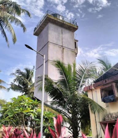
1902. Active; focal plane 85 m (279 ft); three white flashes every 20 s. 21 m (69 ft) square concrete tower with lantern and gallery, painted white; lantern roof painted red. Kamal Irukulla's 2022 photo is at right, Nasa Anil Kumar has a 2021 photo, a 2009 photo is available, Swechha Prakash has a street view, and Google has a satellite view. Apparently this light was built originally as the front light of a range, with the old lighthouse (previous entry) as the rear light. It is not known when the range was discontinued. Located a short distance west of Fort Aguada. Site open, tower open daily 10 am to 5:30 pm. ARLHS IND-069; Admiralty F0606; NGA 27772.
Aguada Point
Date unknown. Active; focal plane 26 m (86 ft); red flash every 3 s. 12 m (39 ft) (?) round stone tower with gallery; lantern removed. Tower painted white. Victoria Bensley has a closeup 2006 photo, Sushanta Banerjee has a view from the sea (also showing the Fort Aguada Light atop the hill), and the tower is centered in Google's fuzzy satellite view. The lighthouse is a short distance west of the historic Aguada Jail. Located on the point below Fort Aguada, at the northern entrance to the Mandovi estuary and Panaji harbor. Site status unknown. Operator: Panaji Port Authority. ARLHS IND-070; Admiralty F0607; NGA 27776.

1902 Aguada Light, Candolim, September 2022
Google Maps photo
by Kamal Irukulla

Information available on lost lighthouses:

Notable faux lighthouses:

Adjoining pages: South: Kerala | North: Maharashtra

Return to the Lighthouse Directory index | Ratings key

Posted January 30, 2006. Checked and revised August 23, 2024. Lighthouses: 35. Site copyright 2024 Russ Rowlett and the University of North Carolina at Chapel Hill.