Lighthouses of India: Maharashtra

The Republic of India (Bhārat in Hindi) is the seventh largest country and second most populous country in the world. It occupies a subcontinent of Asia that projects southward into the North Indian Ocean, separating the Bay of Bengal on the east from the Arabian Sea on the west. Before 1947 it was a patchwork of regions governed as British colonies and semi-independent princely states under British supervision. In 1947 this British Raj was partitioned into the independent states of India and Pakistan. Several French and Portuguese colonies embedded in the territory of India were absorbed in 1950 and 1961, respectively.

India is a federal union of 28 states and 8 union territories. This page lists lighthouses of the western coast of India in the State of Maharashtra, including the greater Mumbai (Bombay) area. This region includes most of the Konkan Coast, the most rugged section of the Indian coastline, where the mountains known as the Sahyādri or Western Ghats rise close behind the shore.

The major lighthouses of India are staffed, and by tradition most of them are open to visitors for a short time during the late afternoon every day; inquire locally concerning the times.

Hindi and English are official languages in India, with English serving as a lingua franca for the entire nation. The Indian Constitution recognizes another 21 languages, called scheduled languages, and each of the coastal states has its own scheduled language in official use. In Marathi, the official language of Maharashtra, the word for a lighthouse is prakāśastambha (प्रकाशस्तंभ) bēṭa is an island, nadī is a river, and bandara is a harbor.

Lighthouses and aids to navigation in India are administered by the Directorate General of Lighthouses and Lightships (DGLL), an agency of the Ministry of Shipping. The coastal lighthouses on this page from the Ratnagiri District northward are maintained by the Mumbai Directorate of DGLL, while those of the Sindhudurg District are maintained by the Goa Directorate. Lighthouses in Mumbai Harbour are maintained by the Mumbai Port Trust.

ARLHS numbers are from the ARLHS World List of Lights. Admiralty numbers are from volume F of the Admiralty List of Lights & Fog Signals. U.S. NGA List numbers are from Publication 112.

General Sources
Aids to navigation: Mumbai Region and Goa Region
Lighthouse information from DGLL, including photos for most of the lighthouses.
Lighthouses in India
Photos by various photographers available from Wikimedia.
World of Lighthouses - India
Photos by various photographers available from Lightphotos.net.
Online List of Lights - India
Photos by various photographers posted by Alexander Trabas. Photos currently available are by Douglas Cameron.
Indian Lighthouses
Historic postcard images posted by Michel Forand.
Leuchttürme Asiens auf historischen Postkarten
Historic postcard images posted by Klaus Huelse.
Navionics Charts
Navigation chart for India's west coast.

Kanhoji Angre (Khanderi Island) Light, Mumbai, October 2015
Wikimedia Creative Commons photo by Anand Ranade

Konkan Coast Lighthouses South of Mumbai

Sindhudurg District (Vengurla Area) Lighthouses
This area is the heart of the very scenic Konkan Coast, backed by the mountains known as the Western Ghats. Many areas of this coast are rarely visited and lack tourist facilities, so information on these lighthouses is needed.
*** Vengurla Point (3)
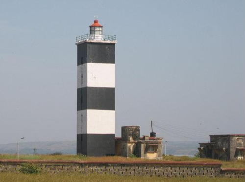
1968 (station established 1869). Active; focal plane 82 m (269 ft); red flash every 5 s.13 m (43 ft) hexagonal cylindrical masonry tower with lantern and gallery, attached to a 1-story keeper's house. Lighthouse painted with black and white horizontal bands; lantern dome painted red. Kedar Sule's photo is at right, Lisbon Rebello has a closeup photo, Sushant Dabholkar has a 2023 closeup, Rinat Khairetdinov has a 2019 closeup, and Google has a satellite view. Located atop a seaside bluff at Vengurla. Accessible by road. Site open, tower open daily 4 to 5:30 pm. ARLHS IND-120; Admiralty F0600; NGA 27800.
Vengurla Rocks (Burnt Islands) (1)
1870. Inactive since 1890. Approx. 10 m (33 ft) octagonal stone tower, lantern removed long ago, centered on a square building. Open fires were displayed from the lighthouse until the lantern and optical equipment arrived from England in 1876. The lighthouse was described as having a focal plane height of 40 m (131 ft). Rajesh Prabhu has a 2022 photo, a 15-second video shows the lighthouse, a very distant view from the sea (third photo on the page) is available, and Bing has an indistinct satellite view. The Vengurla Rocks are bare rocks best known as a breeding site for a rare bird, the Indian swiftlet. Located on the westernmost reef of the Vengurla Rocks about 800 m (1/2 mi) west of the 1890 lighthouse. Accessible only by boat and landing appears difficult or impossible. Site and tower closed.
Vengurla Rocks (Burnt Islands) (2)
1890 (station established 1870). Active; focal plane 49 m (161 ft); two white flashes every 20 s. 21 m (69 ft) round cast iron tower with lantern and gallery, painted with red and white horizontal bands. Lighthouse Digest has a photo, ARLHS has Vithoba Kerkar's aerial photo, a 2021 photo is available, Bhushan Parab has a view from the sea, an Instagram photo is available, Rajesh Prabhu has a 2022 photo, and Google has a satellite view. Located in the Arabian Sea about 11 km (7 mi) off the coast and 20 km (13 mi) west northwest of Vengurla. Accessible only by boat and landing appears difficult or impossible. Site and tower closed. ARLHS IND-009; Admiralty F0598; NGA 27804.

Vengurla Point Light, Vengurla, March 2007
ex-Flickr photo copyright Kedar Sule; used by permission
Malvan (Malwan) Bay Range Rear
Date unknown (station established 1903). Active; focal plane 18 m (59 ft); green flash every 3 s. 14 m (46 ft) square steel skeletal tower. Upper portion of the tower painted red, lower part white. No photo available but Bing has ann indistinct satellite view. The front light is on a short mast. This light guides local fishermen and is displayed only during fair weather when they are at sea. Lights were displayed at Malwan at least as early as 1878, and a light on a mast was established in 1903. Located behind the beach at Malvan, a village about 32 km (20 mi) north of Vengurla. Site status unknown. Admiralty F0596.1; NGA 27824.
Achra (Achara) Point (2)
2014. Active; focal plane 49 m (161 ft); two white flashes every 6 s. Approx. 22 m (72 ft) (?) round concrete tower with lantern and gallery. Lighthouse painted white, lantern roof red. Abhay Aparaj has a 2019 photo and a closeup of this new lighthouse, Nikhil Karangutkar has a 2022 photo, Jayanti Dhuri has a very distant view and Google has a satellite view. NGA lists a 9 m (30 ft) skeletal tower at this location, and an Indian Notice to Mariners identified that light as "temporarily extinguished" in 2012. The new lighthouse should have a focal plane of about 61 m (200 ft). Located on a steep headland across the estuary entrance at Achra, a village about 50 km (30 mi) north of Vengurla. Site status unknown. Admiralty F0592; NGA 27832.
* Devgad (Davgarh, Devgarh) (2)
1958 (station established 1915). Active; focal plane 42 m (138 ft); four white flashes every 23 s. 11 m (36 ft) round masonry tower with lantern and gallery, painted with black and white horizontal bands; lantern dome painted red. Pandurang Bhise has a 2019 closeup photo (also seen at right), Yash Talekar has a 2018 photo, Kothanda Srinivasan also has a photo, a 2012 photo shows the radar antenna mounted above the lantern, and Google has a satellite view. The lighthouse is built within the walls of a ruined early 18th century fortress. Located on a promontory at south side of the harbor entrance at Devgarh, about 80 km (50 mi) north of Vengurla. Site open, tower closed. ARLHS IND-084; Admiralty F0590; NGA 27828.
[Vijaydurg (Vijayadurg)]
Date unknown. Active; focal plane 16 m (52 ft); white, red or green light depending on direction. 6 m (20 ft) mast atop a fortified wall. Swapnil Dabade has a 2021 street view but the light is not visible in Google's satellite view. The light is on an outer rampart of the Vijaydurg Fort, a massive and famous structure dating from the 12th century. It guides vessels into the natural harbor of Vijaydurg. NGA misspells the name as Vijayadrug. Located at the northeast corner of the fort and the south side of the entrance to the harbor. Sute status unknown. Operator: Maharashtra Maritime Board. Admiralty F0588; NGA 27836.

Devgad Light, Devgarh, February 2019
Google Maps photo by Pandurang Bhise

Ratnagiri District Lighthouses
Ragapur Bay (Wagapur, Wajapur, Tarapur) Point (2)
1958 (station established 1873). Active; focal plane 46 m (151 ft); white flash every 15 s. 23 m (75 ft) square cylindrical masonry tower with lantern and gallery, attached to a 1-story concrete keeper's cottage. Lighthouse painted with black and white horizontal bands; lantern dome painted red. Prathamesh Dhawde has a closeup photo, Wikimapia has several photos, and Google has a satellite view. The original lighthouse was a 6.5 m (21 ft) tower. Located on the point at the south side of the entrance to Rajapur Bay, about 45 km (28 mi) west of Rajapur. An unpaved cart track leads to the lighthouse. Site open, tower closed. ARLHS IND-122; Admiralty F0586; NGA 27840.
Musakazi Point
Date unknown. Active; focal plane 35 m (115 ft); two white flashes every 7.5 s. 9 m (30 ft) square pyramidal skeletal tower. No photo available but Google has a satellite view. NGA misspells the name as Musargagi. Located on a headland on the north side of the entrance to Rajapur Bay, opposite the Wagapur lighthouse. Site status unknown. Admiralty F0587; NGA 27844.
Pawas Point (2)
Date unknown. Active; focal plane about 22 m (72 ft); two white flashes every 15 s. NGA lists a small skeletal tower with a focal plane of 11 m (36 ft), but Bing's satellite view shows a slender, much taller tower. Located on a headland about 10 km (6 mi) south of the Ratnagiri lighthouse. Site and tower closed (access is through an industrial plant). Admiralty F0583; NGA 27850.

Wagapur (Rajapur) Light, Rajapu
unattributed photo (probably from DGLL) posted by Wikimapia
** Ratnagiri (Rathnagiri) (3)
1965 (station established 1867). Active; focal plane 102 m (335 ft); two white flashes every 10 s. 15 m (49 ft) round masonry tower with lantern and gallery, painted with black and white horizontal bands; lantern dome painted red. Kristina Hoeppner's photo is at right, Karishma Pais has a photo, Akash Bhise has a 2018 photo, and Google has a satellite view. The original lighthouse, a 10 m (33 ft) masonry tower, was replaced by a skeletal tower in 1940. The lighthouse is within the walls of Ratnagiri Fort. Located on heights on the south side of the harbor at Ratnagiri. Accessible by road. Site open, tower open for tours daily 4 to 5 pm. ARLHS IND-110; Admiralty F0580; NGA 27856.
Warori Bluff
Date unknown. Active; focal plane 50 m (164 ft); white flash every 10 s. 9 m (30 ft) square pyramidal skeletal tower. No photo available but Bing has an indistinct satellite view. Located atop a steep slope at Kharviwada. Site status unknown. Admiralty F0579; NGA 27864.
** Jaigarh (Jaigarh Head, Jaigad, Karateshwar) (3)
1933 (station established 1896). Active; focal plane 41 m (135 ft); four white flashes every 20 s. 22 m (72 ft) round cast iron tower with lantern and gallery, painted with red and white horizontal bands. Several 1-story keeper's houses. Paramantapa Dasgupta has a 2012 closeup, Prasad Gohad has a 2017 photo, Bhavesh Sawant has a 2022 photo, and Google has a satellite view. The original light, mounted on a bastion of Jaigarh Fort, was replaced by a skeletal tower in 1899. Nilesh Korgaonkar has an account of a visit to the lighthouse in 1998; he found the lighthouse was not automated and keepers were still winding the clockwork rotating mechanism by hand. Located on a promontory about 50 km (30 mi) south of Guhagar. Site open, tower open for tours daily 4 to 5 pm. ARLHS IND-087; Admiralty F0578; NGA 27868.
Jaigarh (Jaigad) Breakwater
2012. Active; focal plane 20 m (66 ft); white flash every 10 s. Approx. 17 m (56 ft) square pyramidal skeletal tower, painted white. A very distant view from the Karhateshwar Temple is available, Jaydeep Tagadiya also has a very distant view, and Google has a satellite view. Locared on the breakwater on the south side of the entrance to the Shastri River. Site status unknown. Operator: JSW-Jaigarh Port. Admiralty F0577.5.
Boria Bay
Date unknown. Active; focal plane 37 m (121 ft); red flash every 5 s. 9 m (30 ft) square pyramidal skeletal tower. No closeup photo available but Mahesh Dilip Salvi has a fuzzy street view, Mandar Zarve has a very distant view and Google has an indistinct satellite view. Located on a prominent headland at Velneshvar. Site status unknown. Admiralty F0577; NGA 27880.
Palshet
Date unknown. Active; focal plane 59 m (194 ft); two white flashes every 6 s. 9 m (30 ft) square pyramidal skeletal tower. No photo available and Google has an indistinct satellite view. This light is only seen by vessels sailing south along the coast. Located atop a cliff north of Palshet Bay. Site status unknown. Admiralty F0576; NGA 27884.

Ratnagiri Light, Ratnagiri, April 2007
Flickr Creative Commons photo by Kristina D.C. Hoeppner
*** Tolkeshwar Point (Anjanvel, Port Dabhol) (3)
1958 (station established 1880). Active; focal plane 104 m (341 ft); three white flashes every 15 s. 14 m (46 ft) square cylindrical masonry tower with lantern and gallery, painted white; lantern dome painted red. A closeup photo is at right, Ranjit Wagh has a 2017 photo, Praveen Jadhav has a closeup photo, a 2011 closeup is available (near the bottom of the page), Nilesh Korgaonkar reports on a 1998 visit, and Google has a satellite view of the station. The original cast iron post light was replaced by a short masonry tower in 1934. Located on a high promontory near Dabhol, about 20 km (13 mi) north northwest of Guhagar. Site open, tower open daily 3 to 5 pm. ARLHS IND-117; Admiralty F0566; NGA 27888.
* Harnai
1899. Active; focal plane 29 m (95 ft); red flash every 5 s. 10 m (33 ft) round concrete tower with gallery; the lantern has been replaced by a light on a short mast. The lighthouse was formerly painted white, but in photos it seems most of the paint has weathered off. Khalil Sawant has a 2008 closeup photo, Raja Mahale has a photo, Mandar Gurav has a closeup photo, and Google has a satellite view. Located atop a narrow promontory, connected to the mainland by a causeway, on the north side of the harbor entrance at Harnai. Site probably open, tower closed. ARLHS IND-086; Admiralty F0564; NGA 27904.
* Anjarle (Kelshi)
2021. Active; focal plane unknown; white flash every 15 s. Danish Palte has a December 2020 photo of the lighthouse under construction, Pramod Jadhav has a May 2022 photo of the completed lighthouse, Suraj Sheth has a 2023 photo, and Google has a satellite view. Located on a prominent headland at Dapoli. Site open, tower closed. Admiralty F0563.5.
[Srivardhan Bay (2)]
Date unknown. Active; focal plane 46 m (151 ft); four quick white flashes every 5 s. 9 m (30 ft) post. The post is seen in a 2021 video by Vikas Kumar but Google has only an indistinct satellite view.The post replaced a 9 m (30 ft) square pyramidal skeletal tower. Located on a prominent headland at Srivardhan. Site status unknown. Admiralty F0563; NGA 27912.
 

Raigad District Lighthouses
Nanwell (Nanvell) Point (Rajpuri Point)
1964 (station established 1884). Active; focal plane 66 m (217 ft); three white flashes every 15 s. 19 m (62 ft) octagonal masonry tower, painted with red and white horizontal bands. Prajyot Sale has a 2022 photo, Pritam Patil has a 2018 closeup photo, Sachchida Nand Arya has a photo, Wikimapia has photos, and Google has a satellite view. The original light was a 10.5 m (34 ft) white tower. In 1998 Nilesh Korgaonkar had a long hike from Nanvell to reach the lighthouse, where he had tea with the keepers. Located on a promontory at the southern entrance to the Rajpuri Creek estuary, about 80 km (50 mi) west of Mangaon. Site open but quite difficult to reach, tower may be open by arrangement with the keepers. ARLHS IND-104; Admiralty F0562; NGA 27908.
Tolkeshwar Point Light
Tolkeshwar Point Light, Dabhol, October 2012
Flickr Creative Commons photo by Ankur P.
[Murud Janjira (Bandar Hill) (2)]
Date unknown. Active; focal plane 80 m (262 ft); two white flashes every 15 s. 9 m (30 ft) post. Bipin Patil has a photo but the location of the light is uncertain in Google's satellite view. NGA lists a skeletal tower and the square concrete pad for such a tower is seen in Patil's photo. DGLL took over the post light in 2018. Located atop a hill on the north side of the entrance to Rajpuri Creek. Site status unknown. Admiralty F0559; NGA 27916.
* Korlai Fort (Chaul)
1955. Active; focal plane 33 m (108 ft); white flash every 3 s. 16 m (52 ft) square cylindrical masonry tower with lantern and gallery, attached to the front of a 2-story masonry keeper's house. Tower painted with black and white horizontal bands; lantern dome painted red. Harshal Sonawane's photo is at right, Mithila Rane has a photo, Vinit Maheshwari has a 2007 photo, and Google has a satellite view and a fuzzy street view. Ruins of the early 16th century Korlai fort, built in a successful campaign to expel the Portuguese from Chaul, are on the hill above the lighthouse; a long stairway connects the fort and the light station. Located on a promontory on the north side of the entrance to Chaul, about 18 km (11 mi) south of Alibag and 40 km (25 mi) south of the Mumbai (Bombay) metropolitan area. Site open, tower closed. ARLHS IND-081; Admiralty F0558; NGA 27928.
Chaul Kadu Reefs
1870. Active; focal plane 17 m (56 ft); red flash every 3 s. 19 m (62 ft) round cylindrical masonry tower with gallery, painted white. Lantern removed. In front of the lighthouse is a prow-shaped masonry wall meant to break the force of any waves that might reach the tower. The lighthouse was built with a refuge room to shelter shipwrecked sailors. Bing has a satellite view. Located about 5 km (3 mi) offshore and about 10 km (6 mi) southwest of Alibag. Accessible only by boat. Site and tower closed. ARLHS IND-001; Admiralty F0557.6; NGA 27924.
* Alibag (Kolaba Fort, Kulaba Fort)
Date unknown (station established 1890). Active; focal plane 10 m (33 ft); continuous light, white or green depending on direction. Approx. 7 m (23 ft) post rising from a square stone tower mounted on the southernmost bastion of the Kolaba Fort. Siddharth Panigrahi has a photo, Rohit Hannurkar has a 2017 street view, a closeup is available, and Google has a satellite view of the bastion. The Kolaba Fort is a famous 17th century Maratha stronghold, a center of resistance to British occupation. Located on an island about 2 km (1.25 mi) southwest of Alibag. A popular tourist destination, the fort is accessible by passenger ferry from Alibag. Site open, tower closed. Admiralty F0557; NGA 27932.

Korlai Fort Light, Chaul, June 2019
Google Maps photo by Harshal Sonawane
** Kanhoji (Khanoji) Angre (Khanderi Island, Kennery Island)
1867. Active; focal plane 47 m (154 ft); two flashes every 10 s, white or red depending on direction. 23 m (75 ft) octagonal cut stone tower with lantern and gallery, attached to a 2-story keeper's house. 1st order Fresnel lens in use. The tower is unpainted; lantern painted white; lantern roof is gray metallic. An enclosed observation room has been built on the gallery. Wikimedia has Anand Ranade's photo (also seen at the top of this page), Huelse has a historic postcard view, Forand has a second postcard view, and Google has a satellite view. Khanderi Island is also the site of a 17th century fort. The island is managed by the Mumbai Port Trust. The lighthouse has been renamed for Khanhoji Angre, an early 18th century Maratha admiral who used the island as a base to attack British and Portuguese ships along the west coast of India. In April 2013 it was announced that the station would be opened to visitors for the first time; a new jetty was built to support regular tours from Mumbai. Located about 6 km (4.5 mi) offshore and 10 km (6 mi) northwest of Alibag. Site open, tower open 10 am to 5 pm daily with tours from Mumbai available; there is a very distant view from the mainland. Operator/site manager: Mumbai Port Trust. ARLHS IND-093; Admiralty F0556; NGA 27936
Gull Island (Kashyacha Khadak)
Date unknown. Active; focal plane 26 m (85 ft); white flash every 5 s. 19.5 m (64 ft) steel skeletal tower. Rajkiran Koli has a very distant view, and Google has a satellite view. Located on a small island off the mouth of the Karanja Creek estuary about 5 km (3 mi) north of Mandve and 15 km (9 mi) southeast of Mumbai. Accessible only by boat. Site status unknown. Operator/site manager: Mumbai Port Trust. ARLHS IND-085; Admiralty F0515; NGA 27960.

Mumbai Lighthouses

Mumbai (formerly called Bombay) is India's greatest port and second most populous city. The historic and central portion of the city is located on Salsette Island, which is separated from the mainland by the city's harbor and estuaries called Thane Creek and Vasai Creek. The two creeks are the main distributaries of the Ulhas River. 15 million people live on Salsette Island and the metropolitan population of Mumbai is at least 23 million.

Mumbai Harbour East Side Lighthouses
The east (mainland) side of Mumbai Harbor, including Butcher and Elephanta Islands, is in Raigad District; it is also in the area of the planned city of Navi Mumbai (New Mumbai).
Uran Patch Range Rear
Date unknown. Active; focal plane 12 m (39 ft); quick-flashing white light. 12 m (39 ft) square skeletal tower, lower portion enclosed, mounted on a round pier. Trabas has Cameron's closeup photo and Bing has a satellite view. The range guides vessels southbound on the west side of Elephanta Island. The front light is on a 7 m (23 ft) tower. Located on the southeast side of the harbor off the naval station. Operator/site manager: Mumbai Port Trust. Admiralty F0548.1; NGA 28020.
Sheva Island Range Front
Date unknown. Active; focal plane 54 m (177 ft); quick-flashing red light. Approx. 46 m (151 ft) skeletal tower. No photo available but Bing has a satellite view. Located on a pier in the Jawaharlal Nehru Port, India's largest containership port, on the east side of Mumbai Harbour. Site and tower closed. Operator/site manager: Jawaharlal Nehru Port Trust. Admiralty F0552.3; NGA 28014.
Sheva Island Range Middle
Date unknown. Active; focal plane 66 m (217 ft); red light, 3 s on, 3 s off. Approx. 40 m (131 ft) square skeletal tower. No photo available, but Bing has a satellite view. NGA lists this tower as the rear light of the range. Located on a bluff on the east side of the port. Site and tower closed. Operator/site manager: Jawaharlal Nehru Port Trust. Admiralty F0552.31; NGA 28014.5.
Sheva Island Range Rear
Date unknown. Active; focal plane unknown; red light, pattern unknown. Approx. 19 m (60 ft) skeletal tower mounted on a building and carrying a radar antenna. No photo available, but Google has a satellite view. Located about 1 km (0.6 mi) east northeast of the middle light. Site and tower closed. Operator/site manager: Jawaharlal Nehru Port Trust. Admiralty F0552.32.
Butcher Island
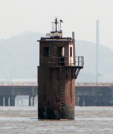
Date unknown. Active; focal plane 9 m (30 ft); four flashes every 10 s, white or red depending on direction. 9 m (30 ft) mast atop a square equipment shelter mounted on a robust round pier. Trabas has Cameron's closeup photo (also seen at right) and Google has a satellite view. Located off the south side of Butcher Island, on the east side of Thane Creek. Accessible only by boat. Site and tower closed. Operator/site manager: Mumbai Port Trust. Admiralty F0549; NGA 28024.

Butcher Island Light, Mumbai Harbour
photo copyright Douglas Cameron; used be permission
Elephanta Island Range Front
Date unknown. Active; focal plane 12 m (39 ft); quick-flashing white light. 12 m (39 ft) slender cylindrical skeletal tower. Trabas has Cameron's photo and Bing has a satellite view. The range guides inbound vessels northbound along the east side of the harbor. Located at the water's edge on the south side of Elephanta Island. Accessible only by boat. Site open, tower closed. Operator/site manager: Mumbai Port Trust. Admiralty F0547; NGA 28008.
Elephanta Island Range Rear
Date unknown. Active; focal plane 22 m (72 ft); quick-flashing white light. Approx. 12 m (39 ft) square skeletal tower. No photo available but Google has an indistinct satellite view. The range guides vessels northbound along the east side of the harbor. Located at the water's edge on the south side of Elephanta Island. Accessible only by boat. Site open, tower closed. Operator/site manager: Mumbai Port Trust. Admiralty F0547.1; NGA 28012.
Barnacle Rock
Date unknown. Active; focal plane unknown; quick-flashing red light. Round masonry tower, height unknown. No photo available but Google has a satellite view. Located in the channel between Elephanta Island and the mainland, in the northeast corner of Mumbai Harbour. Accessible only by boat. Site open, tower closed. Operator/site manager: Mumbai Port Trust. Admiralty F0547.6.
Elephanta Patch
Date unknown. Active; focal plane 8 m (26 ft); white flash every 2 s. 5 m (17 ft) square pyramidal skeletal tower with enclosed upper section, painted white and mounted on a square platform supported by piles. Trabas has Cameron's photo and Google has a satellite view. The Admiralty describes the tower as being black. Located off the west side of Elephanta Island. Accessible only by boat. Site open, tower closed. Operator/site manager: Mumbai Port Trust. Admiralty F0549.5.

Mumbai Harbour West Side Lighthouses
Mumbai includes two districts of Maharashtra: Mumbai City District for the central city area and Mumbai Suburban District for the remainder of Salsette Island.

[North Channel Beacon (3?)]
Date unknown (station established 1897). Active; focal plane 8 m (26 ft); red light, 3 s on, 2 s off. 8 m (26 ft) square skeletal tower mounted on an octagonal concrete pier. Tower painted dark red. No photo available but Google has a satellite view. Located off the Princess Dock north of Cross Island on the west side of Mumbai Harbour. Accessible only by boat. Site open, tower closed. Operator/site manager: Mumbai Port Trust. Admiralty F0532; NGA 27992.
Tucker (Tucker Patch)
1908. Active; focal plane 21 m (69 ft); white or red light, depending on direction, 3 s on, 2 s off. 21 m (69 ft) two-stage tower; a square skeletal tower, painted white, atop a robust round pier. Trabas has Cameron's closeup photo (also seen at right), Shiva M. Misra has a foggy photo, and Bing has a satellite view. Located on a rock in Mumbai Harbour about 5 km (3 mi) northeast of Dolphin Rock. Accessible only by boat. Site and tower closed. Operator/site manager: Mumbai Port Trust. Admiralty F0546; NGA 28004.

Tucker Patch Light, Mumbai Harbour
photo copyright Douglas Cameron; used be permission
Navy Yard South Breakwater (2?)
Date unknown. Active; focal plane 15 m (49 ft); red flash every 3 s. Light mounted on the side of a tall square skeletal communications tower. Trabas has Cameron's photo and the tower is seen in Google's satellite view. Formerly described as a mast mounted on a building. Located at the end of the south breakwater of the Indian Navy base. Site and tower closed. Operator: Mumbai Port Trust. Site manager: Indian Navy. Admiralty F0521; NGA 27972.
Dolphin Rock
1850. Active (?); focal plane 11 m (36 ft); four flashes every 20 s, white to the east northeast and red in other directions. 13 m (43 ft) round stone tower topped by a circular keeper's house, lantern and gallery. The tower is unpainted; keeper's house and lantern painted white. Endangered. Hindol Bhattacharya's July 2007 photo shows the lantern collapsed and it was then removed. Leonora Enking has a 2010 photo, Trabas has Cameron's photo, Jenny Kuykendall has a view of the lighthouse in front of the Mumbai skyline, and Google has a satellite view. An older photo shows the intact lighthouse. Located about 2.5 km (1.5 mi) north of the Sunk Rock Light in Mumbai Harbour. Accessible only by boat. Site and tower closed. Operator/site manager: Mumbai Port Trust. ARLHS IND-002; Admiralty F0520; NGA 27968.
Sunk Rock
1884. Active (?); focal plane 20 m (66 ft); two flashes every 6 s, white along the channel and red in other directions. 22 m (72 ft) round tower with gallery, mounted on a stone pier. Tower painted in a red and yellow checkerboard pattern. Endangered: Tessa Vodafone's 2018 photo shows the lighthouse apparently abandoned and in very poor condition. Trabas has Cameron's photo (also seen at right), a 2010 closeup shows that the lantern had been removed, and Google has a satellite view. Sourendu Gupta's 2006 photo shows the lighthouse with its lantern intact. Swimming races are held between the lighthouse and the Gateway of India, a famous landmark on the Mumbai waterfront. In March 2017 the Port Trust announced plans to restore and develop the lighthouse as a tourist attraction, including decks around the tower to support a restaurant. At last report these plans were under review and negotiation with the Environment Ministry and the Mumbai Heritage Conservation Committee. Located about 2.5 km southeast of the Gateway to India. Accessible only by boat. Site and tower closed. Operator/site manager: Mumbai Port Trust. ARLHS IND-008; Admiralty F0516; NGA 27956.

Sunk Rock Light, Mumbai Harbour
photo copyright Douglas Cameron; used by permission

Mumbai Ocean Side Lighthouses
Prongs Reef (Colaba Point)
1874 (lightship station established 1842). Active; focal plane 41 m (135 ft); white flash every 10 s. 44 m (144 ft) round tapered stone tower with lantern and two galleries, mounted on a stone pier. 1st order Fresnel lens in use. The tower is painted white with a red horizontal band, and the supporting pier is painted black. A photo by Milan Vyas is at right, Mayur Mangela has a photo, Sahil Chauhan has a 2022 photo, Trabas has Cameron's view, a view from shore is available, Huelse has a historic postcard image, and Google has a good satellite view. This historic offshore lighthouse, marking the entrance to Mumbai Harbour, replaced the onshore Colaba Point lighthouse (see below under Lost Lighthouses). It is one of the few offshore lighthouses in the world still staffed; keepers alternate in 15-day shifts. In its early days, the lighthouse was equipped with a cannon to repel pirates. Located about 2.5 km (1.5 mi) south of Colaba Point, the southernmost point of Salsette Island. Accessible only by boat. Site and tower closed. Operator/site manager: DGLL. ARLHS IND-007; Admiralty F0514; NGA 27952.
Uarashi
Date unknown. Active; focal plane 10 m (33 ft); red flash every 10 s. 10 m (33 ft) concrete beacon. No photo available but Google has an indistinct satellite view. Located in the Arabian Sea about 1500 m (0.9 mi) off the Khar West district. Accessible only by boat. Site open, tower closed. Admiralty F0502; NGA 28044.
Madh (Vesava)
Date unknown. Active(?); focal plane 14 m (46 ft); white flash every 2 s. 15 m (49 ft) round 2-stage unpainted concrete tower. Vinayak Meda has a 2021 closeup photo, Sid Nair has a photo, Alankar Joshi has a sunset photo, Mahesh Ramesh has a distant street view from shore, and Google has a satellite view. Located on a rocky point north of Mahd Creek, in the Mira Bhayandar area of northwestern Salsette Island. Site open, tower closed. Admiralty F0500; NGA 28052.
* Uttan Point
1960. Active; focal plane 53 m (174 ft); two white flashes every 15 s. Approx. 17 m (56 ft) square cylindrical masonry tower with lantern and gallery, painted with horizontal red and white bands and attached to a 1-story keeper's house. Ambert Miranda has a 2021 photo, Pravin Ubhare has a photo, Amar Kumar has a 2011 photo, and Google has a satellite view. Located near the northwestern point of Salsette Island, about 50 km (30 mi) north of Mumbai. Accessible by road. Site open, tower closed. ARLHS IND-119; Admiralty F0499; NGA 28060.

Prongs Reef Light, Mumbai, April 2021
Google Maps photo byy Milan Vyas
[Dongri (Donghri) Point]
Date unknown. Active; focal plane 14 m (46 ft); continuous green light. 7 m (23 ft) skeletal mast. Sunil D'Mello has a photo but the small light is not seen in Google's satellite view of the point. NGA lists the tower height as 7 ft. Located on the northwestern point of Salsette Island marking the south side of the entrance to the estuary. Site status unknown. Admiralty F0496; NGA 28064.

Thane District Lighthouses
Bassein (Vasai Creek) (2)
2019. Active; focal plane 5 m (17 ft); quick-flashing red light. Approx. 7 m (23 ft) round concrete or stone tower. Atharva Joshi has a distant 2021 view from shore and Google has a distant satellite view. NGA lists the original light as "metal post, masonry base." An Indian Notice to Mariners reported the light "temporarily extinguished" in 2012. According to a Mumbai Free Press Journal article in May 2019, the "lone badly damaged lighthouse of the region had stopped functioning several years ago" and weather was delaying construction of a new lighthouse. No details of the new lighthouse were provided. Located on a rocky reef about 400 m (1/4 mi) off the north side of the entrance to Vasai Creek. Accessible only by boat. Site open, tower closed. Admiralty F0498; NGA 28056.
* Arnala (5)
2019 (station established 1860). Active; focal plane 33 m (108 ft); three flashes every 15 s, white or red depending on direction. 30 m (98 ft) round concrete tower with lantern and double gallery, painted with black and white spiral bands. Mahendra Kharpade has a March 2020 view from the sea and Google has a satellite view of the new tower. There's a closeup late 2019 YouTube video of the new tower and its 1996 predecessor, a square skeletal tower with double gallery painted white. The older tower was demolished. The original light on a mast was replaced by skeletal towers in 1907 and again in 1967. Located in Arnala, a fishing port about 16 km (10 mi) northwest of Vasai. Accessible by road. Site open, tower closed. ARLHS IND-074; Admiralty F0494; NGA 28068.
* Satpati (2)
2010. Active; focal plane 30 m (98 ft); two white flashes every 20 s. Approx. 25 m (82 ft) round cylindrical concrete tower with lantern and gallery, painted with red and white horizontal bands. A 2023 photo and a 2013 photo are available, Parag Mhatre has a view from the top of the tower, and Google has a 2017 photo and a satellite view. The previous light, described by NGA as a mast, was actually a square skeletal tower with a focal plane of 22 m (72 ft). The lighthouse is on the grounds of the Maharashtra Government Fisheries Training Center in Satpati, a fishing port about 80 km (50 mi) north of Mumbai. Site open, tower closed. Admiralty F0492; NGA 28076.
[Satpati Entrance West]
Date unknown. Inactive; charted by Navionics as a daybeacon. Approx. 9 m (30 ft) round concrete tower. No photo available but Google has a satellite view. Located on the west side of the estuary entrance, about 2 km (1.2 mi) southwest of the new lighthouse. Accessible only by boat. Site open, tower closed.
[Satpati Entrance North]
Date unknown. Inactive; charted by Navionics as a daybeacon. Approx. 9 m (30 ft) round concrete tower. No photo available but Google has a satellite view. Located on the north side of the estuary entrance, about 2 km (1.2 mi) northwest of the new lighthouse. Accessible only by boat. Site open, tower closed.
Tarapur Point
1961. Active; focal plane 25 m (82 ft); three white flashes every 30 s. 23 m (75 ft) square cylindrical masonry tower with lantern and gallery, painted with horizontal black and white bands; lantern roof painted red. A DGLL photo is at right, Sumit Popalkar has a 2020 closeup photo, Raj Davane has a 2022 photo, and Google has a satellite view. Tarapur is the site of a large nuclear power station which also provides plutonium for India's nuclear weaons program. Located on a promontory about 6 km (4 mi) southwest of Tarapur. Site status unknown, probably closed. ARLHS IND-115; Admiralty F0491.5; NGA 28084.

Tarapur Point Light, Tarapur
DGLL photo
* [Dahanu] (2?)
Date unknown. Active; focal plane 13 m (43 ft); white flash every 5 s. 12 m (39 ft) mast. A closeup photo (fifth from last photo on a long page) is available but the mast has not been located in Google's satellite view. NGA lists a skeletal tower. Located on the north side of the entrance to Khongda (Dahanu) Creek at Dahanu, a city of about 80,000 residents. Site open, tower closed. Admiralty F0491; NGA 28088.

Information available on lost lighthouses:

Notable faux lighthouses:

Adjoining pages: North: Southern Gujarat | South: Karnataka and Goa

Return to the Lighthouse Directory index | Ratings key

Posted January 30, 2006. Checked and revised August 13, 2023. Lighthouses: 45. Site copyright 2023 Russ Rowlett and the University of North Carolina at Chapel Hill.