Lighthouses of India: Southern Gujarat and Diu

The Republic of India (Bhārat in Hindi) is the seventh largest country and second most populous country in the world. It occupies a subcontinent of Asia that projects southward into the North Indian Ocean, separating the Bay of Bengal on the east from the Arabian Sea on the west. Before 1947 it was a patchwork of regions governed as British colonies and semi-independent princely states under British supervision. In 1947 this British Raj was partitioned into the independent states of India and Pakistan. Several French and Portuguese colonies embedded in the territory of India were absorbed in 1950 and 1961, respectively.

India is a federal union of 28 states and 8 union territories. The westernmost state, Gujarat, has the longest coastline of any of the states and the largest number of lighthouses. The broad Kathiawar Peninsula, in the center of the state's coastline, separates two major inlets of the Arabian Sea, the Gulf of Khambhat on the southeast and the Gulf of Kutch on the northwest. This page lists lighthouses on the southern coast of Gujarat, facing the open Arabian Sea, including the districts of Amreli, Gir Somnath, Junagadh, and Porbandar, plus the Diu District of the tiny embedded union territory of Dadra and Nagar Haveli and Daman and Diu.

The political history of this region is quite complex. In the British Empire of India the majority of the modern territory of Gujarat was divided into numerous principalities that had control over local economic affairs. Several of these Indian states built lighthouses, including several that survive. After India became independent in 1947 the state of Saurashtra included the area of the Kathiawar Peninsula, the state of Kutch included the area north of the Gulf of Kutch, and the area east of the Gulf of Khambhat was part of Bombay State. In 1956 Saurashtra and Kutch were merged Bombay State, and then in 1960 the northern portion of Bombay State was split off to form Gujarat.

Gujarat is divided into 33 districts and the districts are divided into county-level units called talukas.

Hindi and English are official languages in India, with English serving as a lingua franca for the entire nation. The Indian Constitution recognizes another 21 languages, called scheduled languages, and each of the coastal states has its own scheduled language in official use. In Gujarati, the official language of Gujarat, the word for a lighthouse is dīvādāṇḍī (દીવાદાંડી); tāpu is an island, nadī is a river, and bandara is a harbor.

Lighthouse administration has been under federal control since 1947. Lighthouses and aids to navigation in India are administered by the Directorate General of Lighthouses and Lightships (DGLL), an agency of the Ministry of Shipping. Lighthouses on the east coast of the Gulf of Khambhat are maintained by the Mumbai Directorate of DGLL and the other lighthouses of Gujarat are maintained by the Jamnagar Directorate.

ARLHS numbers are from the ARLHS World List of Lights. Admiralty numbers are from volume F of the Admiralty List of Lights & Fog Signals. U.S. NGA List numbers are from Publication 112.

General Sources
Aids to navigation: Mumbai Region and Jamnagar Region
Lighthouse information from DGLL, including photos for most of the lighthouses.
Lighthouses in India
Photos by various photographers available from Wikimedia.
World of Lighthouses - India
Photos by various photographers available from Lightphotos.net.
Online List of Lights - India - Arabian Sea
Photos by various photographers posted by Alexander Trabas.
Indian Lighthouses
Historic postcard images posted by Michel Forand.

Savaibet Light, Jafrabad, September 2020
Google Maps photo by Abhishek Srivastava
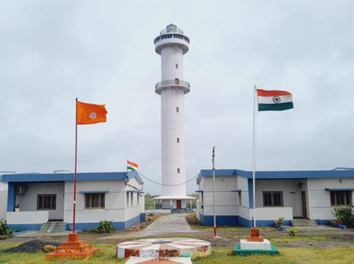

2022 Jafrabad Light, Jafrabad, 2022
photo contributed by Abhishek Srivastava

Amreli District Lighthouses
Savaibet (Savai Bet, Shialbet)
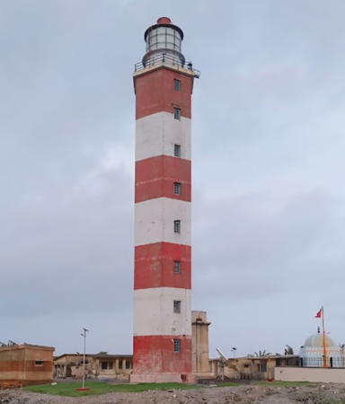
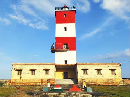
1967. Active; focal plane 45 m (148 ft); four white flashes every 30 s. 27 m (89 ft) square cylindrical masonry tower with lantern and gallery, painted with horizontal red and white bands. Abhishek Srivastava's 2020 photo is at the top of this page, Jeetesh Muchhadia has a photo, Rizvan Khan has a more distant view, and Google has a satellite view. Savaibet is a small island separated from the larger island of Shialbet by a narrow channel at high tide. Located about 25 km (15 mi) east of Jafarabad. Accessible only by boat. Site and tower closed. Operator: DGLL. ARLHS IND-164; Admiralty F0436; NGA 28204.
Pipavav Range No. 1 Front
Date unknown (around 1996?). Active; focal plane 35 m (115 ft); white flash every 3 s. 35 m (115 ft) square pyramidal skeletal tower, painted white. No photo available but Google has a satellite view. Pipavav is a privately-developed port sheltered by Shialbet. Located on the west side of the harbor. Site status unknown. Operator: APM Terminals Pipavav. Admiralty F0437.7.
Pipavav Range No. 1 Rear
Date unknown (around 1996?). Active; focal plane 45 m (148 ft); white light occulting once every 6 s. 45 m (148 ft) square pyramidal skeletal tower, painted white. B.K. Mukesh has a 2022 street view and Google has a satellite view. Located about 250 m (800 ft) north of the front light. Site status unknown. Operator: APM Terminals Pipavav. Admiralty F0437.71.
* Jafrabad (Jafarabad) (2)
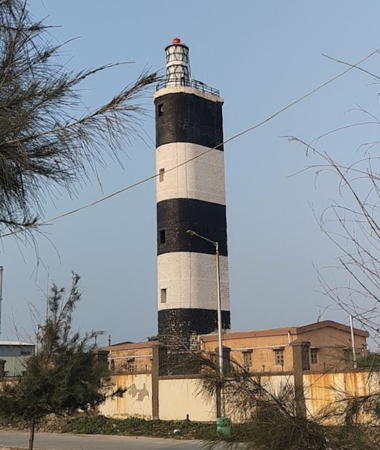
1875 (station established 1865). Inactive since 2022. 19 m (62 ft) round three-stage tower with lantern and two galleries, painted white; lantern roof painted red. Samir Sahu's 2019 photo is at right, Varun Joshi has a photo, Abhishek Srivastava has a 2020 view, Mahadev Parmar has a distant view, and Google has a satellite view. This lighthouse, built by the Indian princely state of Janjira, originally included the lower two stages, an octagonal stone tower on a 2-story square base. The lighthouse was extended by about 6 m (20 ft) in 1962 by adding a round section above the octagonal tower. Located on the west side of the entrance to the harbor of Jafrabad. Site open, tower closed.
* Jafrabad (Jafarabad) (3)
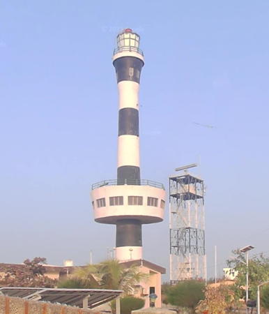
2022 (station established 1865). Active; focal plane 56 m (184 ft); white flash every 10 s. 45 m (148 ft) round cylindrical white concrete tower with observation room and a lower gallery; lantern roof painted red. Abhishek Srivastava's photo is at the top of this page, Tirth Thakar has a 2022 photo of the two lighthouses, and Google has a satellite view. Located behind the historic lighthouse. Site open, tower closed. Operator: DGLL. ARLHS IND-137; Admiralty F0432; NGA 28208.
Jafrabad (Jafarabad) Point
Date unknown. Active; focal plane 8 m (26 ft); continuous red light. 4 m (13 ft) red lantern atop a square 1-story equipment building. The light is on the left in Nirav Gohil's photo, next to a temple to the folk goddess Shitala. Google has a satellite view. Located on a rocky point below the Jafrabad lighthouse. Site open, tower closed. Operator: Gujarat Maritime Board. Admiralty F0432.2; NGA 28212.

1875 Jafrabad Light, Jafrabad, October 2019
Google Maps photo by Samir Sahu

Gir Somnath District: Una Taluka Lighthouses
* Saiyad Rajpara (3)
2020 (station established 1960). Active; focal plane 25 m (82 ft); white flash every 5 s. Approx. 20 m (66 ft) round concrete tower with lantern and gallery. No photo of this new lighthouse has been found but Google has a satellite view. The lighthouse replaced a 7 m (23 ft) square concrete tower atop a 1-story concrete equipment room. Building a new lighthouse was approved by the Ministry of Shipping in February 2020. The original light was on a short skeletal tower. In 1993 the light was moved from the top of the tower to the roof of the equipment room as part of conversion to solar power. Located in Rajpara, a small fishing port 22 km (14 mi) east southeast of Una. Site open, tower closed. Operator: DGLL. ARLHS IND-159; Admiralty F0430.6; NGA 28232.
* Simar (3)
2003 (station established 1901). Active; focal plane 34 m (112 ft); white flash every 10 s. 30 m (98 ft) square skeletal tower, painted with red and white horizontal bands. This tower replaced a concrete post mounted on a 1-story square concrete equipment room; this small beacon may survive. A very distant view is available and Google has a satellite view. The red and white concrete tower shown on the DGLL page is the Diu Head lighthouse placed here in error. The original light was mounted on the old Portuguese fort of Simar, nearby. Located on the waterfront in Simar, a small fishing port 12 km (7.5 mi) southeast of Una. Site open, tower closed. Operator: DGLL. ARLHS IND-165; Admiralty F0430; NGA 28236.
* Nawabandar (Navabandar, Nava Bandar) (2)
1920 (station established 1896). Active; focal plane 27 m (89 ft); four white flashes every 12 s. 15 m (49 ft) round cylindrical masonry tower with lantern and gallery. Lighthouse painted white; lantern roof is red. Seta Ayaj has the 2021 photo at right and Google has a distant street view and a satellite view. We need accurate information on the history of this station. The Jenkins 1904 light list says the first light was a pillar on a rock off the point. This light is easily confused with the Navibandar Light in southwestern Gujarat; that light is listed near the bottom of this page. The two lighthouses are twins, increasing the chance of confusion. Located on a promontory about 12 km (7.5 mi) south of Una, on the south side of the entrance to Nava Bandar harbor. Site open, tower closed. Operator: DGLL. ARLHS IND-156; Admiralty F0426; NGA 28244.

Navabandar Light, Una, February 2021
Google Maps photo by Seta Ayaj

Union Territory of Dadra and Nagar Haveli and Daman and Diu: Diu District Lighthouses
The island of Diu, separated from the mainland by a narrow tidal creek, was occupied by Portugal in 1535 and remained part of Portuguese India until 1961. Since then the island has been governed as a district of the Union Territory of Dadra and Nagar Haveli and Daman and Diu.
Forte do Mar
1902. Active; focal plane 17 m (56 ft); green flash every 4 s. 7 m (23 ft) round cylindrical masonry tower with gallery, painted white. The light is mounted atop a ruined Portuguese fortress. Sanju Mehta has a photo, Samir Chouksey has a photo, Michael Brunet has a photo, Yogesh Ode has a distant view, and Google has a satellite view of the fortress. Located on an islet north of the Couraca lighthouse; the two lighthouses bracket the entrance to Diu's eastern harbor. Accessible only by boat. Site and tower closed. Operator: Diu Port Office. Admiralty F0422; NGA 28256.
* Couraca
1902. Active; focal plane about 40 m (131 ft); red flash every 4 s. 4.5 m (15 ft) hexagonal masonry tower with gallery. Entire lighthouse is white. Andrey Kolychev's 2024 photo is at right, a 2018 photo and a 2012 photo (first photo on the page) are available, and the tiny tower is visible in Google's satellite view. Located at the eastern tip of Diu island, marking the harbor entrance. Site open, tower closed. Operator: Diu Port Office. Admiralty F0424; NGA 28260.
** Cavaleiro (2)
1967 (station established 1897). Active; focal plane 45 m (148 ft); white flash every 2 s. 14 m (46 ft) round cylindrical concrete tower with lantern and double gallery, painted with horizontal black and white bands. Sangani Ghanshyam has a closeup, a 2008 photo is available, Ansul Pratap has a closeup street view, and Google has a satellite view. The lighthouse stands in the historic Portuguese fort at the eastern end of Diu Island. Site open, tower reported open for climbing for a small fee. Operator: Diu Port Office. . ARLHS IND-127; Admiralty F0420; NGA 28264.
* Vanakbara
Date unknown. Active; focal plane about 10 m (33 ft); three white flashes every 10 s. 9 m (30 ft) round conical white concrete tower. Solanki Dilip has a 2019 photo and Google has a satellite view. NGA misspells the name as Vanakbaka. Located on the southwestern tip of Diu island. Site open, tower closed. Operator: Diu Port Office. Admiralty F0414.2; NGA 28266.

Couraca Light, Diu, May 2024
Google Maps photo by Andrey Kolychev

Gir Somnath District: Kodinar Taluka Lighthouses
* Diu Head (Madhwad) (1)
1882. Inactive since 1969. 9 m (30 ft) hexagonal masonry tower rising from a square masonry keeper's cottage. The old tower, built by the princely state of Baroda, was formerly used for years to support a water supply tank. Asfak Mansuri has a 2023 photo and the photo at right shows the former lighthouse, with the tank removed, behind the modern lighthouse. ARLHS IND-132.
** Diu Head (Madhvad) (2)
1969 (station established 1882). Active; focal plane 59 m (194 ft); white flash every 10 s. 37 m (121 ft) hexagonal masonry tower with lantern and gallery, painted with horizontal red and white bands. Sanjay Dhapa's 2024 photo is at right, Chandrapal Lodhari has a 2017 photo Vipul Baria has a 2020 photo, Vijay Dalki has a distant view, and Google has a satellite view. Diu Head is the southernmost point of Saurashtra, making this a crucial light for shipping along the coast. Located on a promontory on the west entrance to Madhvad Bay, about 4 km (2.5 mi) west of Diu Island. The promontory is accessible from the mainland by a mile-long causeway. Site open, tower open for climbing Friday through Sunday. Operator: DGLL. ARLHS IND-131; Admiralty F0414; NGA 28268.
Muldwarka East Range Front
Date unknown. Active; focal plane 22 m (72 ft); occulting red light, period not listed. Approx. 20 m (66 ft) square skeletal tower. Google has a street view and Bing has a satellite view. Muldwarka Port is a specialized port used by the Ambuja Cements company for importing coal and exporting cement. Located just off the main road in the port area. Site status unknown. Operator: Muldwarka Port. Admiralty F0413.5.
Muldwarka East Range Rear
Date unknown. Active; focal plane 22 m (72 ft) (?); continuous red light. Approx. 25 m (82 ft) square skeletal tower. No closeup photo available but Google has a satellite view and a distant street view. Located just behind the coal storage yard, 280 m (920 ft) north northwest of the front light. Site status unknown. Operator: Muldwarka Port. Admiralty F0413.51.
Muldwarka West Range Front
Date unknown. Active; focal plane 22 m (72 ft); flashing white light, period not listed. Approx. 20 m (66 ft) square skeletal tower. Google has a street view and a satellite view. Located just off the main road in the port area, about 200 m (330 ft) west of the East Front Light. Site status unknown. Operator: Muldwarka Port. Admiralty F0413.4.
Muldwarka West Range Rear
Date unknown. Active; focal plane 22 m (72 ft) (?); continuous white light. Approx. 25 m (82 ft) square skeletal tower. No photo available but Google has a satellite view. Located just behind the coal storage yard, 310 m (1015 ft) north northwest of the front light. Site status unknown. Operator: Muldwarka Port. Admiralty F0413.41.

Diu Head Light, Madhvad, July 2024
Google Maps photo by Sanjay Dhapa
Muldwarka Jetty
Date unknown. Active; focal plane 25 m (82 ft); three white flashes every 10 s. Approx. 20 m (66 ft) 2-stage square skeletal tower. Jay Makavana has a distant view from the nearby beach and Google has an indistinct satellite view. Located at the end of the jetty. Site and tower closed. Operator: Muldwarka Port.. Admiralty F0413.
* Dhamlej
Date unknown. Abandoned as of 2016; possibly reactivated. 7 m (23 ft) square cylindrical tower covered with white tiles. A closeup photo (halfway down the page) is available and Google's satellite view shows the lighthouse. Although the Admiralty takes no notice of it, this lighthouse may be or may have been reactivated. Following some lobbying by the regional Centre for Social Justice, the goverment advertised in 2017 for a solar-powered LED lantern to be provided to the Dhamlej lighthouse. We need information on whether the lantern was installed. Located on the beach in Dhamlej, a fishing village within the municipality of Kodinar. Site open, and the tower also stands open. Not listed by the Admiralty.
* Sutrapada (Sutrapara)
Date unknown. Active (?); focal plane 6 m (20 ft); white flash every 7 s. 4 m (13 ft) square white masonry tower. The lighthouse appears at 0:20 in a video by Divyesh Danidhar but it appears to be abandoned. The light is centered in Google's satellite view. Located on the beach in front of the Ramdevpir Temple in Sutrapada. Site open, tower closed. Admiralty F0407; NGA 28270.
* Bhirbhanjan (Bhirria)
1936. Active; focal plane 9 m (30 ft); red flash every 10 s. 6 m (20 ft) square cylindrical brick tower, painted red with a white horizontal band. Google has a street view and the small tower is centered in a Google satellite view. Located on the beach 3 km (1.8 mi) east of the Veraval lighthouse. Site open, tower closed. Operator: DGLL. ARLHS IND-168; Admiralty F0412; NGA 28276.
Veraval East Breakwater
Date unknown. Active; focal plane 13 m (43 ft); red flash every 3 s. 4 m (13 ft) light centered atop a 1-story square masonry tower. Lighthouse painted green with a white zigzag band. Yasin Sida has a 2017 photo, Kamal Jhamb has an older photo, and Google has a satellite view. Located at the end of the east breakwater of Veraval harbor. Site status unknown. Operator: Gujarat Maritime Board. Admiralty F0410.1.
* Veraval (1)
1865. Inactive since 1965. 14 m (56 ft) octagonal masonry tower with double gallery. Lantern removed. The lighthouse is painted white. Google has a closeup 2023 street view, the lighthouse is seen (painted a pale green) at the start of Dinesh Bhensla's Google Maps video, and the lighthouse is seen in a Google satellite view. The Gujarat History Twitter feed has a 1900 photo. We need information on the status and condition of this historic tower. Located at the root of the main (southwest) breakwater of Veraval harbor. Site probably open, tower probably closed.
* Veraval (2)
1965 (station established 1865). Active; focal plane 33 m (108 ft); white light occulting once every 15 s. 30 m (98 ft) cylindrical concrete tower, D-shaped in cross section, with lantern and gallery, rising from a 1-story control center. Lighthouse painted with horizontal black and white bands. Ram Vadher's 2022 photo is at right, Ravi Bhagat has a photo, a 2010 photo and another view are available, Lightphotos.net has a closeup photo, and Google has a satellite view. The two-tier lantern carries powerful lights in both Fresnel lenses. Veraval is one of the most important ports for the fishing fleets of Gujarat, so this light station has always been an important one. In 2021 the name of Veraval was changed to Somnath. Located about 2.5 km (1.5 mi) west of the harbor of Veraval. Site open, tower closed. Operator: DGLL. ARLHS IND-166; Admiralty F0410; NGA 28272.

1965 Veraval Light, Veraval, November 2022
Google Maps photo by Ram Vadher

Junagadh District Lighthouses
Junagadh was a princely state controlling a large part of the southern Kathiawar Peninsula. Mangrol was the capital of Junagadh State. It is now a city of about 60,000 residents and an important fishing port. The modern Junagadh District includes only the central portion of the former princely state.

*
Mangrol (3)
1985 (station established 1877). Active; focal plane 37 m (121 ft); two white flashes every 20 s. 35 m (115 ft) hexagonal concrete tower with lantern and gallery, painted with horizontal red and white bands. The lighthouse also has an observation room at the watch room level, plus a control center encircling the middle of the tower. Lighthouse painted with horizontal red and white bands. A 2009 photo and a closeup photo (2/3 the way down the page) are available and Google has a satellite view. The original light was on a mast; it was moved in 1980 atop the port administration building. Located about 300 m from the beach and 500 m (0.3 mi) east of the waterfront in Mangrol. Site open, tower closed. ARLHS IND-147; Admiralty F0406; NGA 28280.
Mangrol West Breakwater (2?)
Date unknown. Active; focal plane 13 m (43 ft); red flash every 3 s. 4 m (13 ft) square skeletal tower painted with black and white horizontal bands. Vijay Khetalpar has a photo, Nishant Prasad has a distant view, Yash Gosiya has a distant street view, and Google has a satellite view. The original light was a 4 m (13 ft) square concrete tower still described by NGA. Located at the end of the west breakwater of Mangrol harbor. Site status unknown. Admiralty F0406.1; NGA 28282.

Porbandar District Lighthouses
* Navibandar (2?)
Around 1920 (station established 1896). Active; focal plane 18 m (59 ft); white flash every 10 s. 15 m (49 ft) round concrete tower with lantern and gallery. Lighthouse painted white, lantern painted black with a red roof. A closeup photo (nearly 2/3 the way down the page) is available and Google has a 2023 street view and a satellite view. The original light was on a corner of an 18th century fort, otherwise in ruins, that was restored for use as a lighthouse. This light is easily confused with the Nawabandar Light just east of Diu; that lighthouse is listed and pictured above. The two lighthouses are twins, which increases the chance of confusion. Located just off the coastal highway about 7 km (4.5 mi) southeast of Navibandar. Site open, tower closed. ARLHS IND-153; Admiralty F0404; NGA 28284.
** Porbandar (2)
1983 (station established 1876). Active; focal plane 47 m (145 ft); white flash every 5 s. 41 m (135 ft) round concrete tower with lantern and gallery; the lighthouse also has a large harbor control room encircling the tower about 1/3 of the way up from the ground. Lighthouse painted with horizontal black and white bands. Google's 2023 street view is at right, Jayrajsinh Vaghela has a 2022 photo, Bandari Laxman has a 2023 photo, Vijay Jethva has a sunset photo, and Google also has a satellite view. Porbandar is an important port and also a tourist attraction; it was the birthplace of Mahatma Gandhi. Located 4 km (2.5 mi) east of the harbor of Porbandar. Site open, tower reported open in the late afternoon daily. ARLHS IND-158; Admiralty F0400; NGA 28288.
* Porbandar (1)
1876. Inactive since 1983. This was a 24 m (79 ft) round tapered sandstone tower with lantern and gallery, painted with black and white horizontal bands. The lantern has been removed and the tower is in poor condition. Prakesh Hathi has a 2010 photo, another good photo (2/3 the way down the page) is available, and Google has a 2023 street view and a satellite view. Endangered. This lighthouse was built and operated by the princely state of Porbandar; it deserves to be restored and maintained as a historic monument. Located on the waterfront in downtown Porbandar. Site open, tower closed.

Porbandar Light, Porbandar, January 2023
Google Maps street view
* Navadra (Nawadra)
1986. Active; focal plane 55 m (180 ft); three white flashes every 15 s. 35 m (115 ft) round cylindrical concrete tower with lantern and gallery, painted with horizontal red and white bands. Karan Ahir has a closeup 2023 photo, Imran Bedi has a distant view, and Google has a good satellite view. This lighthouse was built to provide the first light for the long stretch of coastline between Porbandar and Dwarka. It stands isolated, surrounded by a large wind farm, about 500 m (0.4 mi) from a 25 m (80 ft) cliff. Located off the coastal highway 50 km (30 mi) southeast of Dwarka and the same distance northwest of Porbandar. Site open, tower closed. ARLHS IND-152; Admiralty F0398; NGA 28296.
 

Information available on lost lighthouses:

Notable faux lighthouses:

Adjoining pages: East: Eastern Gujarat | West: Western Gujarat

Return to the Lighthouse Directory index | Ratings key

Posted February 6, 2006. Checked and revised September 16, 2024. Lighthouses: 32. Site copyright 2024 Russ Rowlett and the University of North Carolina at Chapel Hill.