Lighthouses of India: Western Gujarat

The Republic of India (Bhārat in Hindi) is the seventh largest country and second most populous country in the world. It occupies a subcontinent of Asia that projects southward into the North Indian Ocean, separating the Bay of Bengal on the east from the Arabian Sea on the west. Before 1947 it was a patchwork of regions governed as British colonies and semi-independent princely states under British supervision. In 1947 this British Raj was partitioned into the independent states of India and Pakistan. Several French and Portuguese colonies embedded in the territory of India were absorbed in 1950 and 1961, respectively.

India is a federal union of 28 states and 8 union territories. The westernmost state, Gujarat, has the longest coastline of any of the states and the largest number of lighthouses. The broad Kathiawar Peninsula, in the center of the state's coastline, separates two major inlets of the Arabian Sea, the Gulf of Khambhat on the southeast and the Gulf of Kutch on the northwest. This page lists lighthouses of the western part of Gujarat, including the Junagadh, Porbandar, Devbhumi Dwarka and Jamnagar districts at the western end of the Kathiawar peninsula as well as the large Kachchh (Kutch) district on the north side of the Gulf of Kutch.

The political history of this region is quite complex. Under the British Raj the majority of the modern territory of Gujarat was divided into princely states that had control over local economic affairs. Several of these Indian states built lighthouses, including several that survive. After India became independent in 1947 Kutch was established as a state and the Kathiawar peninsula was included in the state of Saurashtra. In 1956 Kutch and Saurashtra were merged into the large state of Bombay, and then in 1960 Bombay state was divided, with its northern portion split off as the state of Gujarat.

Gujarat is divided into 33 districts and the districts are divided into county-level units called talukas.

Hindi and English are official languages in India, with English serving as a lingua franca for the entire nation. The Indian Constitution recognizes another 21 languages, called scheduled languages, and each of the coastal states has its own scheduled language in official use. In Gujarati, the official language of Gujarat, word for a lighthouse is dīvādāṇḍī (દીવાદાંડી); tāpu is an island, nadī is a river, and bandara is a harbor.

Lighthouses and aids to navigation in India are administered by the Directorate General of Lighthouses and Lightships (DGLL), an agency of the Ministry of Shipping. Lighthouses on the south coast of the Kathiawar Peninsula are maintained by the Jamnagar Directorate and those of the Gulf of Kutch are maintained by the Gandhidham Directorate.

ARLHS numbers are from the ARLHS World List of Lights. Admiralty numbers are from volume F of the Admiralty List of Lights & Fog Signals. U.S. NGA List numbers are from Publication 112.

General Sources
Aids to Navigation: Jamnagar Region and Gandhidham Region
Lighthouse information from DGLL, including photos for most of the lighthouses.
Lighthouses in Gujarat
Photos available from Wikimedia.
World of Lighthouses - India
Photos by various photographers available from Lightphotos.net.
Online List of Lights - India
Photos by various photographers posted by Alexander Trabas.
Indian Lighthouses
Historic postcard images posted by Michel Forand.
Navionics Charts
Navigation chart for India's west coast.

Dwarka Point Light, Dwarka, May 2010
Flickr Creative Commons photo by Elvin Lonan

Western Kathiawar Peninsula Lighthouses

Junagadh District Lighthouses
Junagadh was a princely state controlling a large part of the southern Kathiawar Peninsula. Mangrol was the capital of Junagadh State. It is now a city of about 60,000 residents and an important fishing port. The modern Junagadh District includes only the central portion of the former princely state.

*
Mangrol (3)
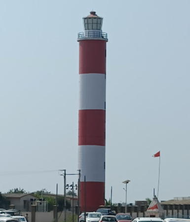
1985 (station established 1877). Active; focal plane 37 m (121 ft); two white flashes every 20 s. 35 m (115 ft) hexagonal concrete tower with lantern and gallery, painted with horizontal red and white bands. The lighthouse also has an observation room at the watch room level, plus a control center encircling the middle of the tower. Lighthouse painted with horizontal red and white bands. A 2009 photo and a closeup photo (2/3 the way down the page) are available and Google has a 2023 street view and a satellite view. The original light was on a mast; it was moved in 1980 atop the port administration building. Located about 300 m from the beach and 500 m (0.3 mi) east of the waterfront in Mangrol. Site open, tower closed. ARLHS IND-147; Admiralty F0406; NGA 28280.
Mangrol West Breakwater (2?)
Date unknown. Active; focal plane 13 m (43 ft); red flash every 3 s. 4 m (13 ft) square skeletal tower painted with black and white horizontal bands. Vijay Khetalpar has a photo, Nishant Prasad has a distant view, Yash Gosiya has a distant street view, and Google has a satellite view. The original light was a 4 m (13 ft) square concrete tower still described by NGA. Located at the end of the west breakwater of Mangrol harbor. Site status unknown. Admiralty F0406.1; NGA 28282.

Porbandar District Lighthouses
* Navibandar (2?)
Around 1920 (station established 1896). Active; focal plane 18 m (59 ft); white flash every 10 s. 15 m (49 ft) round concrete tower with lantern and gallery. Lighthouse painted white, lantern painted black with a red roof. A closeup photo (halfway down the page) is available and Google has a 2023 street view and a satellite view. The original light was on a corner of an 18th century fort, otherwise in ruins, that was restored for use as a lighthouse. This light is easily confused with the Nawabandar Light just east of Diu; that lighthouse is listed on the Southern Gujarat page. The two lighthouses are twins, which increases the chance of confusion. Located just off the coastal highway about 7 km (4.5 mi) southeast of Navibandar. Site open, tower closed. ARLHS IND-153; Admiralty F0404; NGA 28284.
** Porbandar (2)
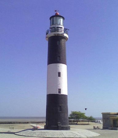
1983 (station established 1876). Active; focal plane 47 m (145 ft); white flash every 5 s. 41 m (135 ft) round concrete tower with lantern and gallery; the lighthouse also has a large harbor control room encircling the tower about 1/3 of the way up from the ground. Lighthouse painted with horizontal black and white bands. A DGLL photo is at right, Jayrajsinh Vaghela has a 2022 photo, Ashok Patel has a photo, Vijay Jethva has a sunset photo, and Google has a 2023 street view and a satellite view. Porbandar is an important port and also a tourist attraction; it was the birthplace of Mahatma Gandhi. Located 4 km (2.5 mi) east of the harbor of Porbandar. Site open, tower reported open in the late afternoon daily. ARLHS IND-158; Admiralty F0400; NGA 28288.
* Porbandar (1)
1876. Inactive since 1983. This was a 24 m (79 ft) round tapered sandstone tower with lantern and gallery, painted with black and white horizontal bands. The lantern has been removed and the tower is in poor condition. Prakesh Hathi has a 2010 photo, another good photo (2/3 the way down the page) is available, and Google has a 2023 street view and a satellite view. Endangered. This lighthouse was built and operated by the princely state of Porbandar; it deserves to be restored and maintained as a historic monument. Located on the waterfront in downtown Porbandar. Site open, tower closed.

Porbandar Light, Porbandar
DGLL photo
* Navadra (Nawadra)
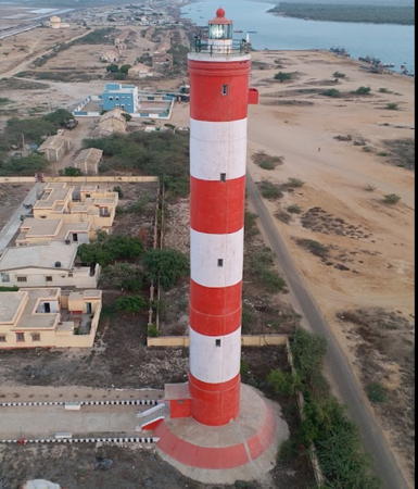
1986. Active; focal plane 55 m (180 ft); three white flashes every 15 s. 35 m (115 ft) round cylindrical concrete tower with lantern and gallery, painted with horizontal red and white bands. A DGLL photo is at right, Imran Bedi has a distant view, and Google has a good satellite view. This lighthouse was built to provide the first light for the long stretch of coastline between Porbandar and Dwarka. It stands isolated, surrounded by a large wind farm, about 500 m (0.4 mi) from a 25 m (80 ft) cliff. Located off the coastal highway 50 km (30 mi) southeast of Dwarka and the same distance northwest of Porbandar. Site open, tower closed. ARLHS IND-152; Admiralty F0398; NGA 28296.

Devbhumi Dwarka District: Dwarka Taluka Lighthouses
The Devbhumi Dwarka District includes the westernmost tip of the Kathiawar Peninsula and the southern entrance to the Gulf of Kutch.

***
Dwarka Point (2)
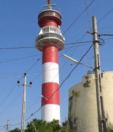
1962 (station established 1866). Active; focal plane 48 m (157 ft); two white flashes every 20 s. 43 m (141 ft) square masonry tower with lantern and gallery, attached to a 1-story keeper's house/harbor control center. Lighthouse painted with horizontal black and white bands. Elvin Lonan's photo is at the top of this page, a 2018 photo is available, Tanmay Vora has a 2008 photo, Wikimedia has a distant view, Harshang Chhaya has a closeup street view, and Google has a satellite view. This is the westernmost lighthouse of Saurashtra and a well-known tourist attraction. The original lighthouse, an 18 m (59 ft) square masonry tower, was built by the native state of Baroda. Located at the end of the peninsula sheltering the west side of the harbor of Dwarka. Site open, tower open daily. . ARLHS IND-133; Admiralty F0396; NGA 28300.
* Kachhigadh (2)
1983 (station established 1977). Active; focal plane 34 m (112 ft); four white flashes every 15 s. 30 m (98 ft) round cylindrical concrete tower with lantern and gallery, painted with horizontal red and white bands. Arvind Prajapati has a 2022 photo, Vatsal Mandavia has a closeup 2021 photo, Sejul Antala has a closeup, R. Ramesh has a street view from the nearby beach, and Google has a satellite view. The station was established with a temporary light on a "cabin" in 1977. It marks the southern approach to the Gulf of Kachchh (Kutch). Located about 15 km (9 mi) north of Dwarka. Site open, tower closed. ARLHS IND-142; Admiralty F0397; NGA 28304.
* Mithapur
Date unknown. Active; focal plane 53 m (174 ft); continuous red light. 49.5 m (163 ft) building. A giant Tata Chemicals plant dominates Mithapur and its main office building is almost certainly the location of the light. A photo is available and Google has a satellite view. Mithapur is about 10 km (6 mi) southwest of Okha. Site open, tower closed. Admiralty F0393; NGA 28320.
Navadra Light
Navadra Light, Porbandar
DGLL photo
* Okha (Vomani Point, Humani Point)
1956. Active; focal plane 26 m (85 ft); three white flashes every 25 s. 23 m (75 ft) square cylindrical concrete tower with lantern and gallery, painted with horizontal red and white bands. Niraj Kumar has a photo. Google's satellite view shows the 60 m (197 ft) round VTS vessel tracking tower built next to the historic lighthouse in 2012. Wikimedia has a view taken from the VTS tower. Okha lies at the end of a north-pointing peninsula that defines the southern entrance to the Gulf of Kachchh (Kutch). After independence western India lost the use of the port of Karachi, Pakistan, so it became important to develop port facilities in the Gulf. This lighthouse was the first major improvement to navigational aids in this development. Located on Vomani (Humani) Point near the tip of the peninsula, adjacent to a historic fort. Site open, tower closed. ARLHS IND-014; Admiralty F0388; NGA 28312.
Samiyani Island (Okha Port)
1876. Active; focal plane 22 m (72 ft); flash every 5 s, white or red depending on direction. 20 m (66 ft) round sandstone tower with lantern and gallery, mounted on a square stone base. Lighthouse painted white; lantern dome is red. A photo is at right, Kashyap Atri has a 2019 photo, and Google has a satellite view. Built by the princely state of Baroda, this elegant and historic lighthouse marks the entrance to Okha harbor. It stands on an island 1.5 km (1 mi) north of Okha Point, the tip of the peninsula. Boat transportation to the island can be hired in Okha. Located in the center of the island. Site open, tower closed. ARLHS IND-018; Admiralty F0390; NGA 28308.
Samiyani Island North (4)
2002 (station established 1935). Active; focal plane 11 m (36 ft); green flash every 3 s. 9 m (30 ft) round cylindrical concrete tower, mounted on a concrete foundation. Lighthouse painted with black and white horizontal bands. Chetan Kanzariya has a distant view and Google has an indistinct satellite view. The original light on a skeletal tower was replaced by a concrete tower in 1957. That lighthouse was destroyed by a tropical cyclone on 9 June 1998. It was replaced by a temporary skeletal tower, and then by the present lighthouse, which probably resembles the 1957 tower. Located in the water just off the northeast tip of Samiyani Island. Accessible only by boat. Site and tower closed. ARLHS IND-163; Admiralty F0389; NGA 28316.
Bural Reef (Chanka Reef)
1979. Active; focal plane 15 m (49 ft); quick-flashing white light. 12 m (39 ft) round cylindrical concrete tower with three galleries but no lantern, painted white. Lightphotos.net has an older photo and Bing has a satellite view. The dangerous Bural Reef extends east northeast from Okha Point. Located about 25 km (15 mi) east northeast of Okha. Accessible only by boat. Site and tower closed. ARLHS IND-126; Admiralty F0386.5; NGA 28328.
Chank Tapu (Chanka Island) (2)
1988 (station established 1934). Active; focal plane 14 m (46 ft); white flash every 15 s. 8 m (26 ft) square cylindrical skeletal tower with gallery, mounted on a large square concrete base. Wikimapia has an older photo and Bing has a satellite view. Lighthouse painted white; the small lantern is red. A stone daybeacon was placed on the reef in 1885; a skeletal tower was added in 1928 but apparently it was not lighted until 1934. Located at the northeastern end of the extensive Chanka Reef system, about 35 km (2 mi) east northeast of Okha. Accessible only by boat. Site and tower closed. Admiralty F0386; NGA 28332.

Samiyani Island Light, Okha, January 2018
Google Maps photo by Vj 84ya

Devbhumi Dwarka District: Khambhalia Taluka Lighthouses
Kalubhar (Karumbhar) Island (Salaya)
1884. Active; focal plane 27 m (89 ft); three white flashes every 15 s. 20 m (66 ft) round stone tower with lantern and gallery, attached to a 1-story keeper's house. Lighthouse painted white; lantern dome is red. Prashant Chauhan's 2020 photo is at right, Mukeshkumar Mali has a distant photo, and Google has a satellite view. This lighthouse, which marks the entrance to the harbor of Salaya, was built by the princely state of Nawanagar. The tower was restored and increased in height in 1961. Located just off the west end of the island about 20 km (12.5 mi) north of Salaya. Accessible only by boat. Site and tower closed. ARLHS IND-169; Admiralty F0384; NGA 28336.
Pathfinder Inlet (Vadinar) Range Front (2 towers)
2015 (station established 2008). Active; focal plane unknown; continuous red light. Mast atop a tall square skeletal tower, height unknown. No photo available but Google has a satellite view. The new port of Vadinar serves area oil refineries. The satellite view shows a second tower just to the north; it's not clear if this is the inactive original tower or if it is an active auxiliary light. Located a short distance south of the port area. Accessible only by boat. Site open, tower closed. Operator: Deendayal Port Trust. Admiralty F0383.75.
Pathfinder Inlet (Vadinar) Range Rear (2 towers)
2015 (station established 2008). Active; focal plane unknown; flashing white light. Mast atop a tall square skeletal tower, height unknown. No photo available but Google has a satellite view. The satellite view shows a second tower just to the north; it's not clear if this is the inactive original tower or if it is an active auxiliary light. Located 750 m (1/2 mi) south of the front light. Accessible only by boat. Site open, tower closed. Operator: Deendayal Port Trust. Admiralty F0383.751.
 

Kalubhar Island Light, Salaya, December 2020
Google Maps photo by Prashant Chauhan

Jamnagar District: Jamnagar Taluka Lighthouses
Sikka Range Front
2011. Active; focal plane unknown; continuous red light. Skeletal tower atop a square platform supported by piles. No photo available but Google has a distant satellite view. Sikka is a traditional fishing port that now also hosts several industrial plants. Located a short distance east of the pier at Sikka. Accessible only by boat. Site open, tower closed. Operator: Sikka Ports and Terminals. Admiralty F0382.5; NGA 28347.
Sikka Range Rear
2011. Active; focal plane unknown; continuous red light. Skeletal tower atop a square platform supported by piles. No photo available but Google has a distant satellite view. Located 500 m (1/3 mi) southeast of the front light. Accessible only by boat. Site open, tower closed. Operator: Sikka Ports and Terminals. Admiralty F0382.51; NGA 28347.5.
Pirotan (Pirothan) Island (2)
1958 (station established 1898). Active; focal plane 26 m (85 ft); white flash every 20 s. 21 m (69 ft) round masonry tower with lantern and gallery, painted with horizontal black and white bands. Jayesh Kumar's photo is at right, Wikimedia has a sunrise photo by S. Ballal, Jayesh Kumar has a 2020 photo, and Google has a satellite view. A seawall protects this highly exposed lighthouse. Pirotan is the beginning of the approach to Bedi, the seaport of the city of Jamnagar. Located on a small island 10 km (6 mi) northwest of Rozi. Accessible only by boat. Site and tower closed. ARLHS IND-157; Admiralty F0380; NGA 28352.
Mawadi Point (Pirotan Northeast) (2)
1958 (station established 1928). Active; focal plane 8 m (26 ft); red flash every 10 s. 8 m (26 ft) short round tower mounted atop a round cylindrical stone tower. The upper tower is painted red with a white horizontal band. The lower tower is unpainted brown stone. Tushar Chhatrara has a photo but the light is not shown in Google's satellite view. The light marks the end of a reef extending northeast from Pirotan Island. The first light was a skeletal tower built on a daybecaon established in 1867. Located about 2.25 km (1.4 mi) northeast of the modern lighthouse. Site open, and nothing prevents climbing on the lighthouse. Admiralty F0378; NGA 28356.
* Rozi Port (Bedi Bandar, Bedi Bundar, Bedi) (2)
Date unknown. Inactive since 2002. Approx. 25 m (82 ft) round cylindrical vessel traffic control tower painted with red and white horizontal bands. Yogesh Masuria has a 2011 photo, a 2016 photo (first photo on the page) is available, Tanmay Vora has a 2012 view from across the harbor, and Google has a satellite view. This tower replaced a 12 m (39 ft) square skeletal tower with a small equipment closet in the base. The light was deactivated because it became redundant on the brightly lit Rozi Pier. Located on the quay at Bedi Bandar, the seaport serving the city of Jamnagar. Site open, tower closed. ARLHS IND-124; ex-Admiralty F0376; ex-NGA 28358.
* Rozi (Rojhi)
1867. Inactive since 1976. Approx. 13 m (43 ft) round cylindrical stone tower, a bastion at the northwest corner of the fortified Rozi Mata temple, now in ruins. Sandeepsinh Sodha has a photo and Google has a satellite view. The original light was on a mast atop the tower; in 1897 it was replaced by a "cast iron pedestal" with a 6th order Fresnel lens. The light was moved to the new Rozi Pier in 1976. Located just east of the base of the pier. Site open, tower status unknown.

Pirotan Island Light, Jamnagar, February 2020
Google Maps photo by Jayesh Kumar
#Rozi Kalvan (Rozi Kalyan) (2)
1966 (station established 1927). Damaged by an earthquake in 2001, the lighthouse later collapsed. This was a 9 m (30 ft) round masonry tower on a concrete base, painted with horizontal black and white bands. The tower is not seen in Google's satellite view and it was dropped from the Admiralty list in 2008. This light was on the approach to Bedi. It was damaged in the great earthquake of 26 January 2001 and collapsed "subsequently," according to Indian Logistics. It was replaced by a buoy. Located east of Rozi Island and about 6 km (3.5 mi) north of the Bedi waterfront. Accessible only by boat. Site and tower closed. ARLHS IND-161; ex-Admiralty F0374; ex-NGA 28360.

Jamnagar District: Jodiya Taluka Lighthouses
Mungra Reef
1890 (rebuilt and lit in 1997; rebuilt a second time in 1999). Active; focal plane 10 m (33 ft); two white flashes every 10 s. 10 m (33 ft) round cylindrical concrete tower on a circular masonry pier. Tower painted red with one white horizontal band. Bing has a satellite view. The lighthouse marks a dangerous reef on the approach to Jodiya Bandar. The native state of Nawanagar built this beacon. It was rebuilt in 1999 after being heavily damaged by a tropical cyclone on 9 June 1998. Located in the Gulf of Kachchh about 12 km (7.5 mi) northwest of Jodiya Bandar. Accessible only by boat. Site and tower closed. ARLHS IND-151; Admiralty F0367.8; NGA 28366.
* Jodiya (Jodia) Bandar (3)
2002 (station established 1903). Active; focal plane 31 m (102 ft); white flash every 10 s. 30 m (98 ft) skeletal tower, painted white. Google has a satellite view. The 1993 lighthouse, a round cylindrical masonry tower with gallery attached to a small square 1-story equipment room, was destroyed by the earthquake of 26 January 2001. The original lighthouse was a small cast iron tower purchased from Chance Brothers by the native state of Nawanagar. Located at Jodiya (Jodia), a small port on the upper Gulf of Kachchh. Site open, tower closed. ARLHS IND-141; Admiralty F0368; NGA 28368.

Kachchh (Kutch) District Lighthouses

Kutch (officially spelled Kachchh) includes all the territory between the Gulf of Kutch and the border of Pakistan to the north. Kutch was a state from 1950 to 1956; it entered Gujarat state as a single district, making it by far the largest district not only in Gujarat but in all of India.

Gandhidham Taluka Lighthouses
Navlakhi (Navlakhi Bet, Kandla Port) (3)
2012 (station established 1932). Active; focal plane 30 m (198 ft); three white flashes every 10 s. 30 m (98 ft) round concrete tower with lantern, gallery, and an observation level, very similar to the Bhadreswar lighthouse at right. Tower painted with horizontal red and white bands. Rajesh Shah has a distant view, and Google has a satellite view. The light guides ships approaching the port facility at Navlakhi at the head of the Gulf of Kachchh. The original light was replaced in 1985 by a 24 m (79 ft) skeletal tower. That lighthouse was knocked out of service by the earthquake of 26 January 2001, but it was restored and returned to service the following month. Located on the northwestern tip of Navlakhi Island. Accessible only by boat. Site and tower closed. ARLHS IND-155; Admiralty F0370; NGA 28376.
Tekra (Tuna) (2?)
Date unknown (station established 1892). Active; focal plane 17 m (56 ft); white flash every 7 s. Formerly described as a 14 m (46) "metal column" atop a masonry tower, painted with black and white horizontal bands. The light is now described by NGA as a "metal column" with black and white horizontal bands. No photo available but Google has a satellite view. The light guides ships entering Kandla Port, a greatly expanded port facility at the head of the Gulf of Kachchh. The original light was described as an "iron column." Located on the west side of a creek entrance in the Kandla Port complex south of Anjar, near the head of the Gulf of Kachchh. Site status unknown. Operator: Adanai Ports Tuna Terminal. Admiralty F0366; NGA 28380.

Mundra Taluka Lighthouses
* Bhadreswar (Nakti Creek)
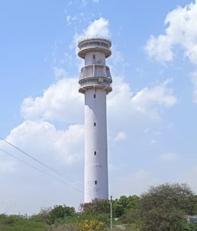
2012. Active; focal plane 77 m (253 ft); three white flashes every 20 s. 60 m (197 ft) round concrete tower with lantern and double gallery. Entire lighthouse is white. A DGLL photo is at right, a 2023 photo is available, and Google has a satellite view. This light is mounted on a vessel traffic control tower. Located at Bhadreswar, a village about 30 km (19 mi) northwest of Mundra. Site open, tower closed. Admiralty F0365; NGA 28378.
#Mundra New Port (Mitha Port) (3)
1985 (station established 1951). Inactive since 2011 and probably demolished. This was a 7 m (23 ft) square cylindrical concrete column attached to a 1-story concrete equipment room. No photo available and Google's satellite view does not show the light. A new port, sheltered from the summer monsoon winds, was developed at Mundra during the 1950s. In 1998-2001 a major new Mundra Port was developed by private interests. The original lighthouse was a skeletal tower. Located on the Mitha quay, a small boat quay within the Mundra port area. Site open, tower closed. ARLHS IND-150; ex-Admiralty F0364; ex-NGA 28400.
Bhadreswar Light
Bhadreswar Light, Mundra
DGLL photo
Mundra Port Range Front
Date unknown. Active; focal plane 19 m (62 ft); quick-flashing green light. Approx. 18 m (59 ft) square pyramidal skeletal tower. No photo available but Bing has a satellite view. Located on the waterfront of Mundra New Port. Site status unknown. Operator: Adani Ports Mundra Port. Admiralty F0361.8; NGA 28398.
Mundra Port Range Rear
Date unknown. Active; focal plane 34 m (112 ft); occulting green light. Approx. 32 m (105 ft) square pyramidal skeletal tower. No photo available but Google has a satellite view. Located about 1.6 km (1 mi) northwest of the front light. Site status unknown. Operator: Adani Ports Mundra Port. Admiralty F0361.81; NGA 28398.5.
Navinal (Navinar) Point (Mundra Port) (3)
2003 (station established 1892). Inactive since 2020. 40 m (131 ft) triangular skeletal tower mounted on a platform supported by piles. No photo available but Google has a satellite view. The NGA listing for Navinal Point is confused; it has the location of this light but the description "White structure, black bands" fits the traffic control tower (next entry). This was a temporary location for the light after the second (1965) lighthouse had to be removed for devlopment of the port. Located on the waterfront of the port. Site and tower closed. ex-Admiralty F0362; NGA 28396.
Navinal (Navinar) Point (Mundra Port) (4)
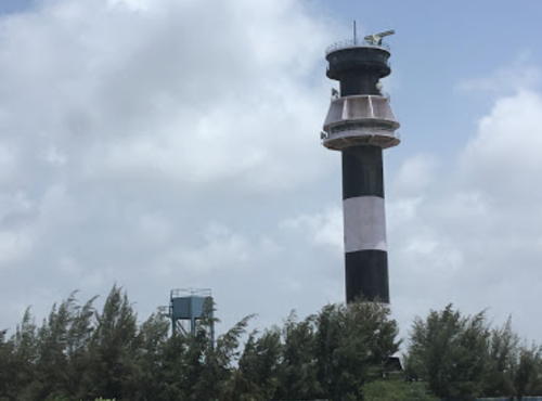
Date unknown (station established 1892). Active; focal plane about 65 m (213 ft); two white flashes every 15 s. 60 m (197 ft) round cylindrical concrete vessel traffic control tower with lantern and gallery, painted with horizontal black and white bands; lantern roof painted red. Google has a 2018 photo and a satellite view. Navinal Point is a swampy point of land sheltering Mundra Creek; Admiralty F0361.82.
Adani (Mundra West) Port Range Front
Date unknown. Active (privately maintained?); focal plane about 20 m (66 ft); light characteristic unknown. Approx. 20 m (66 ft) skeletal tower. No photo available but Google has a satellite view. Located at the Adani Port on the west side of Mundra. Site and tower closed. Operator: Adani Ports Mundra Port. Admiralty F0360.9.

Navinal Light, Salaya, August 2018
Google Maps photo by Serald
Adani (Mundra West) Port Range Rear
Date unknown. Active (privately maintained?); focal plane about 40 m (131 ft); light characteristic unknown. Approx. 40 m (131 ft) skeletal tower. No photo available but Google has a satellite view. Located about 1.5 km (1 mi) northeast of the front light. Site and tower closed. Operator: Adani Ports Mundra Port. Admiralty F0360.91.


Mandvi Taluka Lighthouses
* Rawal Pir (3) (?)
1969 (station established 1936). Inactive since 2020. 7 m (23 ft) square cylindrical concrete column attached to a 1-story concrete equipment room. Lighthouse painted white. A Bing satellite view may show this small light. The original light was mounted on the tomb of a revered Sufi master (known as a pir). A separate tower was provided in 1947 and replaced in 1969. Located close to the Ravdpir (Rawal Pir) Temple complex about 3 km (2 mi) east of Mandvi. Site open, tower closed. ARLHS IND-160.
Rawal Pir (4)
2020 (station established 1936). Active; focal plane 40 m (131 ft); green flash every 3 s. 31 m (102 ft) round concrete tower with lantern and two galleries painted with red and white spiral bands. A 2022 closeup photo is available, Samat Vagha has a 2021 photo and Google has a satellite view. The listed location is the same as for the original light. Admiralty F0360; NGA 28404.
* Mandvi Breakwater (3)
1957 (station established 1890). Active; focal plane 8 m (26 ft); red flash every 3 s. 7 m (23 ft) square cylindrical concrete tower, upper half painted red and lower half white. Sahil Rayma has a 2017 photo and a 2020 photo, Parth Parmar has a photo showing the lighthouse in silhouette, Chandresh Malamwala has a distant view, Aresh Hirani has a street view across the harbor entrance, and Google has a satellite view. Located at the end of the west breakwater at Mandvi Harbour. Accessible by walking the pier. Site open, tower closed. ARLHS IND-146; Admiralty F0358; NGA 28408.
* #Mandvi (Mandvi Fort) (3)
1964 (station established 1856). Demolished in 2001. This was a round cylindrical tower with lantern and gallery mounted on a round stone tower 17th century fortress of Mandvi; the light was listed with a focal plane of 35 m (115 ft). Google has a satellite view of the fortress. Heavily damaged in the earthquake of 26 January 2001, the lighthouse was pulled down the following month. Located on the south side of the new lighthouse. Site open, status of the fortress tower unknown.
* Mandvi (5)
2012 (station established 1856). Active; focal plane 63 m (207 ft); three white flashes, separated by 5 s, every 30 s. 30 m (98 ft) round cylindrical concrete vessel traffic control tower with two circular observation levels. Lighthouse painted with red and white horizontal bands. Imran Shaikh's photo is at right, Tanmay Vora has a closeup photo, Hardik Dhayani has a 2015 photo, Vinay Toprani has a photo, and Google has a 2023 street view and a satellite view. The 1964 lighthouse (previous entry) was a cylindrical concrete tower with lantern and gallery; that lighthouse was demolished after being heavily damaged by the earthquake of 26 January 2001. It was replaced by a skeletal tower until the present tower was built. Mandvi has been the major port of the Kachchh district for many centuries. The lighthouse is built on the historic Mandvi Fort, from which lights were often displayed when friendly ships were expected. Although DGLL dates the modern light station to 1873, Ken Trethewey's research indicated that the British built a lighthouse on the fort in 1856. Light lists indicate that a taller tower was built in 1889. Located near the waterfront in Mandvi. Site open, tower probably open but we have no information on this. ARLHS IND-145; Admiralty F0357; NGA 28411.
Mandvi Light
Mandvi Light, Mandvi, November 2010
ex-Panoramio photo copyright Imran Shaikh; used by permission

Abdasa Taluka Lighthouses
* Chhachhi (Kachchigadh) (2)
1964 (station established 1957). Active; focal plane 33 m (108 ft); three white flashes every 15 s. 31 m (102 ft) square cylindrical masonry tower with lantern and gallery. Lighthouse painted with horizontal black and white bands; lantern roof painted red. DGLL's photo shows the lighthouse and the much taller traffic control tower that has stood next to it since 2008. Saurabh Parmar has a 2019 photo of the two towers, Niraj Kumar also has a photo, and Google has a satellite view of the two towers. This is an important lighthouse marking the northern entrance to the Gulf of Kachchh. Located near the village of Chhachhi about 50 km (30 mi) north northwest of Mandvi. Site open, although roads in the area are poor; tower closed. ARLHS IND-015; Admiralty F0356; NGA 28416.
* Jakhau (2)
1965 (station established 1957). Active; focal plane 46 m (151 ft); white flash every 10 s. 41 m (135 ft) round cylindrical concrete tower with lantern and gallery, painted with horizontal red and white bands. Chandrakant Swain's 2018 photo is at right, DGLL has a photo of the 60 m (197 ft) traffic control tower that stands next to the lighthouse, Chandrakant Swain has a photo of both towers, and Google has a satellite view. The original lighthouse here was replaced in 1964. Located on the main quay of Jakhau, a fishing port in western Kachchh. Site open, tower closed. ARLHS IND-138; Admiralty F0355; NGA 28420.

Lakhpat Taluka Lighthouse
* Koteshwar
2014 (?). Active; focal plane 60 m (197 ft); two white flashes every 15 s. Approx. 57 m (187 ft) round cylindrical concrete tower with lantern and gallery, painted with black and white horizontal bands. Jay Thakker has a 2023 photo, Tanmay Vora has a photo, Lightphotos.net has a photo, and Google has a satellite view. This is both the northernmost and the westernmost lighthouse of India. It has strategic value, standing to the east of the disputed Rann of Kutch area on the Pakistani frontier. Located on the south side of the village of Koteshwar facing the inlet known as Kori Creek. Site open, tower closed. Admiralty F0354; NGA 28420.5.

Information available on lost lighthouses:

  • Okha Point (1935-1956), Okha. This was a 30 m (98 ft) skeletal tower located about 3 km (2 mi) from the modern Okha lighthouse on Vomani Point. ex-Admiralty F0392.

Jakhau Light, Jakhau, April 2018
Google Maps photo by Chandrakant Swain

Notable faux lighthouses:

Adjoining pages: East: Southern Gujarat | West: Pakistan

Return to the Lighthouse Directory index | Ratings key

Posted February 6, 2006. Checked and revised August 27, 2023. Lighthouses: 44. Site copyright 2023. Russ Rowlett and the University of North Carolina at Chapel Hill.