Lighthouses of Japan: Southern Hokkaidō

The nation of Japan, known in Japanese as Nihon or Nippon (日本), occupies an archipelago off the east coast of Asia. The four main islands are Hokkaidō in the north, Honshū (the largest) in the center, Shikoku in the south, and Kyūshū in the southwest. The country includes thousands of other islands of all sizes; among them the Ryūkyū (Nansei) Islands are a long chain extending to the southwest and including the large island of Okinawa, and the Nanpō Islands are another long chain extending south into the Pacific Ocean. Much of Japan is mountainous but the coastal regions are densely populated and urbanized; the country's population is about 126 million.

Hokkaidō, the northernmost of the four main islands of Japan, is very roughly triangular in shape, facing northeast on the Sea of Okhotsk, southeast on the Pacific Ocean, and west on the Sea of Japan. It is separated from Honshū to the south by the Tsugaru Strait and from Russian Sakhalin to the north by the La Pérouse or Sōya Strait.

Japan is divided into 47 prefectures. The entire island of Hokkaidō forms a single prefecture, making it by far the largest of the 47. The prefecture is divided into nine administrative regions, called subprefectures in English. The subprefectures of Hokkaidō are similar in size to the prefectures in the other main islands.

This page covers lighthouses of Oshima Subprefecture, which includes the east and south coasts of the twisting Oshima Peninsula at the southwest end of Hokkaidō. This coast faces Uchiura Bay and the Tsugaru Strait.

In Japanese, the word for a lighthouse is tōdai or toudai (灯台). The words saki and misaki are for capes and headlands, hana ("nose") is a promontory, hantō is a peninsula, shima (also spelled sima or jima) is an island, bae is a reef, iwa or shi is a rocky reef, amase or se is a shoal, wan is a bay, nada is a sound or basin, kaikyō is a strait, kawa is a river, and or minato is a harbor.

Lighthouses in Japan are operated and maintained by the Japanese Coast Guard's Maritime Safety Agency. Lighthouses in Oshima subprefecture are maintained by the Hakodate Coast Guard office.

ARLHS numbers are from the ARLHS World List of Lights. JCG numbers are the Japanese Coast Guard's light list numbers. Admiralty numbers are from volume M of the Admiralty List of Lights & Fog Signals. U.S. NGA List numbers are from Publication 112.

General Sources
Lighthouses in Japan - Hokkaidō
Photos and data for Hokkaidō lighthouses.
Lighthouse-Japan.com - Hokkaidō
Another site with excellent photos and text in Japanese.
Misty's Japanese Lighthouse Tour - Hokkaidō
Photos and brief notes in English.
Form of a Lighthouse
Another site with many photos of lighthouses in northern Japan, cited below as FOAL.
Lighthouse Visits
Another good source of lighthouse photos.
Lighthouses in Hokkaido Prefecture
Photos available from Wikimedia.
Hakodate Section Lighthouses
Small photos and data from the Hakodate Coast Guard Station web site.
Japan: Modern Lighthouses
Historic postcard views posted by Michel Forand.
Online List of Lights - Japan
Photos by various photographers posted by Alexander Trabas. Photos for this area are by Jim Smith.
Navionics Charts
Navigation chart for southern Hokkaidō.

Esan Misaki Light
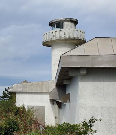
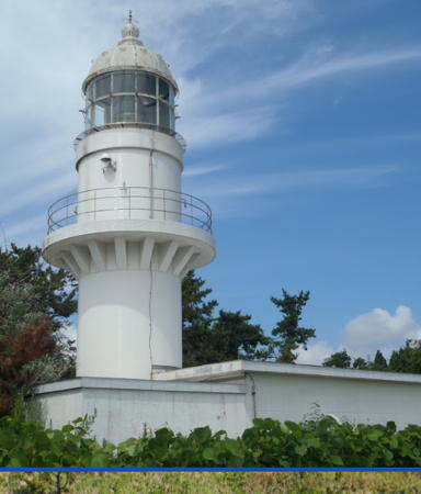
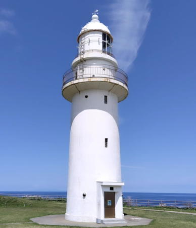
Esan Misaki Light, Hakodate, June 2008
ex-Panoramio Creative Commons photo by Ryu-two


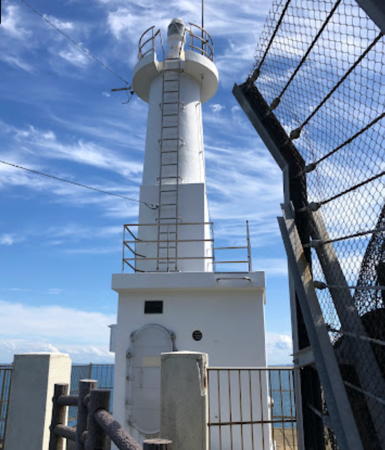
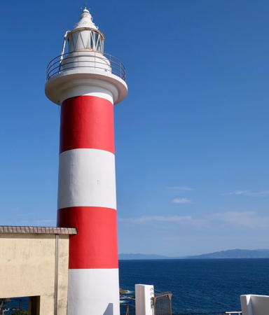
Shiokubi Misaki Light, Hakodate, August 2022
Google Maps photo by 鉄仮面DR30
Yakumo Town Lighthouse
Yakumo Kō
Date unknown. Active; focal plane 12 m (39 ft); two green flashes every 6 s. 9 m (30 ft) concrete post rising from a square 1-story concrete equipment building. Entire lighthouse is white. Google has a satellite view and a distant street view across the harbor. Located at the end of the east breakwater of Yakumo, a port on the central west coast of Uchiura Bay. Site status unknown. ARLHS JPN-1014; JCG-0049; Admiralty M6741.3; NGA 0824.

Mori Town Lighthouses
#Ebiya (Ishiya) Kō (1)
Date unknown. Replaced in late 2010 or early 2011. This was a 5 m (17 ft) concrete post attached to a square 1-story concrete equipment building. Entire lighthouse was white. The active light (focal plane 8.5 m (28 ft); green flash every 3 s) is on a simple post. Google has a satellite view and a distant October 2022 street view of the new light. Located at the end of the east breakwater of Ishiya, a port in the Mori municipality on the southwest coast of Uchiura Bay. Site status unknown. Current light: JCG-0048.1; Admiralty M6741.05; NGA 0816.5.
Sawara (Sunahara) Kō
Date unknown. Active; focal plane 12 m (39 ft); red light, 3 s on, 3 s off. 10 m (33 ft) round cylindrical fiberglass tower. Entire lighthouse is red. Google has a satellite view. Located at the east end of the main breakwater of Sawara, about 3.2 km (2 mi) southwest of the Suna Saki lighthouse. Site status unknown. JCG-0047; Admiralty M6740; NGA 0812.
Suna Saki
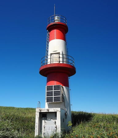
1952. Active; focal plane 14 m (46 ft); white flash every 4 s. 12 m (39 ft) 2-stage round concrete tower with two galleries, painted white with a narrow red horizontal band at the top of each stage. A photo is at right, Lighthouse-Japan.com has good photos, Misty's Tour has a photo taken at sunset, FOAL's page has additional photos, Tomozou Kitano has a 2021 photo, and Google has a satellite view and a foggy street view. This light appears to have been doubled in height by addition of the second stage. Located on Suna Saki ("Sand Cape"), which marks the south side of the entrance to Uchiura Wan (opposite Chikiu Misaki), about 2 km (1.2 mi) northeast of Sawara. Accessible by a dirt road about 2 km (1.2 mi) long; 4WD recommended. Site open, tower closed. . ARLHS JPN-599; JCG-0046; Admiralty M6738; NGA 0828.

Shikabe Town Lighthouse
* Shikabe (Sikaba) Kō
Date unknown. Active; focal plane 14 m (46 ft); green flash every 3 s. 8.5 m (28 ft) concrete post attached to a square 1-story concrete equipment building. Entire lighthouse is white. Google has a satellite view and a distant street view across the harbor. Located at the end of the east breakwater at Shikabe, a town about 25 km (15 mi) southeast of Suna Saki. Accessible by walking the pier. Site open, tower closed. JCG-0045; Admiralty M6735; NGA 0832.

Suna Saki Light, Mori, February 2016
ex-Google Plus photo by Zero 363

Hakodate City Lighthouses
The capital of Oshima Subprefecture, Hakodate is a seaport with a population of about 300,000. The city occupies the Kameda Peninsula, which projects southeastward aheltering the north side of the Tsugaru Strait.

* Usujiri (Usuziri Wan) North Breakwater
Date unknown. Active; focal plane 11 m (36 ft); two green flashes every 6 s. 9 m (29 ft) concrete post attached to a square 1-story concrete equipment building. Entire lighthouse is white. Google has a satellite view and a very distant street view. Located at the end of the original north breakwater of Uzujiri, a fishing port on the north side of the Kameda Peninsula. Accessible by walking the pier. Site open, tower closed. ARLHS JPN-1006; JCG-0043; Admiralty M6733; NGA 0836.
* Osatsubetsu (Osatsube) Kō
Date unknown. Active; focal plane 11 m (36 ft); continuous green light with a more intense flash every 5 s. 9 m (29 ft) concrete post attached to a square 1-story concrete equipment building. Entire lighthouse is white. Google has a street view and a satellite view. Located at the end of the main breakwater of Osatsubetsu, a fishing port about 8 km (5 mi) southeast of Usujiri. Accessible by walking the pier. Site open, tower closed. ARLHS JPN-944; JCG-0041; Admiralty M6731; NGA 0848.
* Todohokke Kō
Date unknown. Active; focal plane 15 m (49 ft); green flash every 4 s. 9.5 m (31 ft) concrete post attached to a square 1-story concrete equipment building. Entire lighthouse is white. Google has a satellite view and a distant street view across the harbor entrance. Located at the end of the main breakwater of Todohokke, a small port on the north side of Esan Misaki. Accessible by walking the pier. Site open, tower closed. ARLHS JPN-994; JCG-0040; Admiralty M6730; NGA 0852.
* Esan Misaki (3)
Date unknown (station established 1890). Active; focal plane 44 m (144 ft); white light, 3 s on, 3 s off. 19 m (62 ft) round concrete tower with lantern and gallery, painted white. A photo is at the top of this page, Lighthouse-Japan.com has excellent photos, FOAL has another page for the lighthouse, Misty's Tour also has a photo, John Lander has a 2009 photo, another photo is available, and Google has a street view and a satellite view. This lighthouse marks the eastern entrance to the Tsugaru Strait, which separates Hokkaidō from Honshū. The first lighthouse was a 15 m (50 ft) cast iron tower; it was replaced in 1900 by a hexagonal wood tower seen in Forand's postcard view. The second lighthouse burned after being attacked with strafing fire from U.S. planes on 15 July 1945, during the last days of World War II. In 1995 the area around the lighthouse was developed as a tourist attraction with a Lighthouse Family Museum and trails to nearby volcanic hot springs. That museum closed in April 2016 but it has been renovated and reopened as the Hakodate City Lighthouse Museum. Located on a sharp promontory at the end of the Kameda Peninsula about 40 km (25 mi) east of downtown Hakodate. Accessible by road; parking provided. Site open, tower closed. Site manager: Hakodate City (Cape Esan Lighthouse Park). . ARLHS JPN-061; JCG-0039; Admiralty M6729; NGA 0856.
Yamasedomari Kō South Breakwater
Date unknown. Active; focal plane 12 m (39 ft); red light, 2 s on, 2 s off. 11 m (36 ft) round hourglass-shaped concrete tower with lantern and gallery. Entire lighthouse is red. Google has a satellite view and a distant street view across the harbor. Located on the south breakwater of a small harbor on the south side of Cape Esan. Site status unknown. ARLHS JPN-1015; JCG-0037; Admiralty M6727; NGA 0860.
* Ōma Gyoko (Ōshima) Kō North Breakwater
Date unknown. Active; focal plane 13 m (43 ft); red flash every 3 s. 11 m (36 ft) round cylindrical concrete tower with lantern and gallery. Entire lighthouse is red. Google has a satellite view and a distant street view across the harbor. Located on the east breakwater of a small harbor on the east side of Hiura Misaki. Accessible by walking the pier. Site open, tower closed. JCG-0036; Admiralty M6726.
* Hiura Misaki
1951. Active; focal plane 23 m (75 ft); white or red light, depending on direction, occulting twice every 12 s. 10 m (33 ft) round conical tower attached to a small equipment shelter. Entire lighthouse painted white. A photo is at right, the Lighthouse of Japan has good photos, Misty's Tour has a photo, FOAL's page has photos, and Google has a satellite view and a very distant street view. Located on a rocky promontory just east of Toi and 13 km (8 mi) southwest of Esan Misaki. Accessible by a stairway from the small port on the east side of the cape. Site open, tower closed, although the tower can be seen from nearby. ARLHS JPN-128; JCG-0035; Admiralty M6725; NGA 0864.
Hiura Misaki Light
Hiura Misaki Light, Hakodate, September 2006
ex-Panoramio photo copyright T_ojisan; used by permission
* Toi Kō South Breakwater
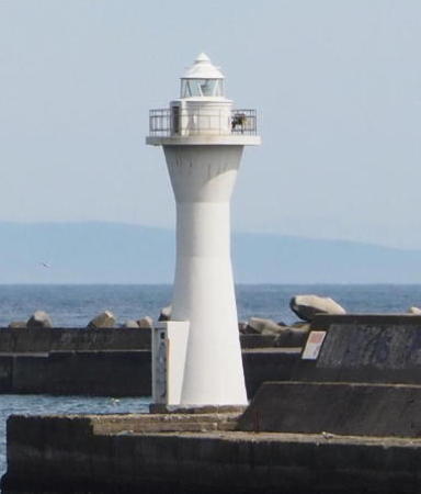
Date unknown. Active; focal plane 12 m (39 ft); green flash every 4 s. 11 m (36 ft) round hourglass-shaped concrete tower with lantern and gallery. Entire lighthouse is white. Shingichi Nagai has the 2021 photo seen at right and Google has a satellite view and a distant street view across the harbor. Located on the south breakwater of a small harbor on the east side of Hiura Misaki. Accessible by walking the pier. Site open, tower closed. ARLHS JPN-996; JCG-0034; Admiralty M6724.4; NGA 0868.
* Shiokubi (Siokubi) Misaki
Date unknown (station established 1893). Active; focal plane 50 m (164 ft); two white flashes every 20 s. 11 m (36 ft) round cylindrical concrete tower with lantern and gallery, attached to a 1-story keeper's house. Entire lighthouse painted white. A photo is at the top of this page, a 2020 photo is available, Lighthouse-Japan.com has excellent photos, FOAL's page has photos, Misty's Tour also has photos, Google's street view shows the steepness of the cape, and Google also has a satellite view. This lighthouse marks the narrowest point of the Tsugaru Strait; from here it is 18 km (11 mi) to Oma Saki, the extreme northern tip of Honshū. Google has a street view across the strait. The station escaped serious damage in the U.S. strafing run of 15 July 1945. Located on a bluff above the coastal highway about 25 km (15 mi) east of Hakodate. Accessible by a long and steep stairway (a strenous climb!); limited parking is available nearby. . ARLHS JPN-572; JCG-0032; Admiralty M6724; NGA 0876.
* Hakodate Fishery Harbor (Hakodate Gyoko) West Breakwater
Date unknown. Active; focal plane 10 m (33 ft); two red flashes every 5 s. 9.5 m (31 ft) concrete post attached to a square 1-story concrete equipment building. Entire lighthouse is red. Trabas has Smith's view, and Google has a satellite view and a distant street view across the harbor. The breakwater was extended about 50 m (165 ft) around 2012 and the light was relocated to the end of the extension. Located at the end of the breakwater of the fishing port on the southwest side of Hakodate. Accessible by walking the pier. Site open, tower closed. JCG-0027; Admiralty M6715; NGA 0896.
Hakodate Outer Breakwater
Date unknown. Active; focal plane 15 m (49 ft); red flash every 3 s. 15 m (49 ft) round cylindrical concrete tower with lantern and gallery. Entire lighthouse is red. Trabas has Smith's closeup photo, FOAL has a photo (right photo in sixth row), and Google has a satellite view. Located at the northwest end of a short outer breakwater, outside the west breakwater of Hakodate. Accessible only by boat. Site and tower closed. JCG-0019.5; Admiralty M6707.5; NGA 0898.

Toi Kō South Breakwater Light, Hakodate, May 2021
Google Maps photo by Shingichi Nagai
Hakodate West Breakwater (2)
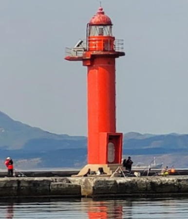
Date unknown. Active; focal plane 13 m (43 ft); two red flashes every 6 s. 14 m (46 ft) round cylindrical concrete tower with lantern and gallery. Entire lighthouse is red. Trabas has Smith's photo (also seen at right), FOAL has a photo (left photo in sixth row), and Google has a satellite view. This light and the next one flank the main entrance to the port of Hakodate, where ferries arrive throughout the day from Aomori on Honshū. Forand has a postcard view of an earlier light near this location. Located at the north end of a detached breakwater. Accessible only by boat. Site and tower closed. ARLHS JPN-862; JCG-0020; Admiralty M6706; NGA 0900.
Hakodate North Breakwater
Date unknown. Active; focal plane 14 m (46 ft); two green flashes every 6 s. 14 m (46 ft) round cylindrical concrete tower with lantern and gallery. Entire lighthouse is white. FOAL has two photos (second row and third row left), Trabas has Smith's photo, a 2022 view from the sea is available, and Google has a satellite view. This light and the previous one flank the main entrance to the port of Hakodate, where ferries arrive throughout the day from Aomori on Honshū. Located at the south end of a detached breakwater. Accessible only by boat. Site and tower closed. ARLHS JPN-860; JCG-0019; Admiralty M6707; NGA 0904.
Hakodate North Auxiliary Breakwater
Date unknown. Active; focal plane 12 m (39 ft); red flash every 3 s. 12 m (39 ft) round cylindrical concrete tower with lantern and gallery. Entire lighthouse is red. Trabas has Smith's photo, FOAL has a photo (right photo in third row), and Google has a satellite view. Located at the end of a detached breakwater off the north end of the north breakwater of Hakodate harbor. Accessible only by boat. Site and tower closed. ARLHS JPN-859; JCG-0017; Admiralty M6707.4; NGA 0908.
Hakodate Training Wall Number 3
Date unknown. Active; focal plane 12 m (39 ft); continuous green light with a brighter flash every 5 s. 12 m (39 ft) tapered square skeletal tower with gallery. Entire lighthouse is white. Trabas has Smith's photo, FOAL has two photos (fourth row), and Google has a satellite view. Located at the south end of a breakwater on the northwest side of Hakodate harbor. Site and tower closed. ARLHS JPN-861; JCG-0018; Admiralty M6708; NGA 0912.

Hakodate West Breakwater Light, Hakodate
photo copyright Jim Smith; used by permission

Hokuto City Lighthouse
* Kattoshi Misaki (2?)
Date unknown (station established 1885). Active; focal plane 46 m (151 ft); white light, 6 s on, 4 s off. 16 m (52 ft) round cylindrical concrete tower with lantern and gallery, attached to a small 1-story keeper's house. Entire lighthouse painted white. A fog bell used from 1892 to 1938 is mounted outside the lighthouse. A closeup photo is at right, Lighthouse-Japan.com site has good photos, FOAL's page has photos, Trabas has Smith's view from the sea, and Google has a street view and a satellite view. Located on a bluff on the west side of the entrance to Hakodate Bay from the Tsugaru Strait, about 20 km (13 mi) southwest of the city by the coastal highway. The lighthouse is accessible by a trail from the coastal highway, but the nearest parking is more than 800 m (1/2 mi) to the west. Site open, tower closed. . ARLHS JPN-243; JCG-0012; Admiralty M6702; NGA 0928.

Shiriuchi Town Lighthouse
Yagoshi Misaki
1957. Active; focal plane 96 m (315 ft); white flash every 10 s. 8 m (26 ft) round cylindrical concrete tower with lantern and gallery, rising from a small 1-story keeper's house. Entire lighthouse painted white. Saegusa Shō has a 2021 drone view and Google has a satellite view. Located on a high promontory on the northwest side of the Tsugaru Strait about 8 km (5 mi) south of Shuriuchi. Accessible only by boat; this is a remote and roadless area. Site status unknown. ARLHS JPN-745; JCG-0005; Admiralty M6698; NGA 0944.

Fukushima Town Lighthouses
* Fukushima (Hukushima) Kō
Date unknown. Active; focal plane 11 m (36 ft); green light, 2 s on, 2 s off. 9.5 m (31 ft) concrete post attached to a square 1-story concrete equipment building. Entire lighthouse is white. Google has a satellite view and a distant street view across the harbor. Located at the end of the east (main) breakwater of Fukushima, a fishing port about 16 km (10 mi) northeast of Cape Shirakami. Accessible by walking the pier. Site open, tower closed. ARLHS JPN-875; JCG-0003; Admiralty M6695; NGA 0948.
Kattoshi Misaki Light
Kattoshi Misaki Light, Hakodate, May 2010
ex-Panoramio photo copyright pincyapo; permission requested
* Yoshioka Kō
Date unknown. Active; focal plane 14 m (46 ft); continuous green light with a more intense flash every 6 s. 9 m (30 ft) concrete post attached to a square 1-story concrete equipment building. Entire lighthouse is white. Google has a satellite view and a distant street view across the harbor. Located at the end of the east (main) breakwater of Yoshioka, a fishing port about 8 km (5 mi) northeast of Cape Shirakami. Accessible by walking the pier. Site open, tower closed. ARLHS JPN-1024; JCG-0002; Admiralty M6693; NGA 0956.

Matsumae Town Lighthouses
Shirakami (Sirakami) Misaki (2)
Date unknown (station established 1888). Active; focal plane 37 m (121 ft); flash every 30 s, alternately red and white. 17 m (56 ft) round cylindrical concrete tower with lantern and gallery, attached to a 1-story keeper's house. Lighthouse painted with red and white horizontal bands. This lighthouse has an old-style lantern with a traditional high-peaked roof, a feature now rare in Japan. Koichi Yokota's photo is at right, Lighthouse-Japan.com has excellent photos, FOAL's page has photos, Misty's Tour has several photos, Wikimedia has Kiriboshi Daikon's photo, Trabas has Smith's view from the sea, and Google has a street view and a satellite view. This is the first light in Japan's light list. In late 2008 or early 2009 the lighthouse was repainted, and it now has a white lantern and two red bands. Forand has a historic postcard view of the original lighthouse. Cape Shirakami, at the end of the Matsumae peninsula, is the southernmost tip of Hokkaidō and the western entrance to Tsugaru Strait; Google has a street view across the strait to Honshū. The lighthouse stands just above the coastal highway (which plunges through two tunnels below the light), but unfortunately parking at the gate is very limited. Located at the point of the cape. Site gated, although many visitors step over the gate; tower closed. . ARLHS JPN-576; JCG-0001; Admiralty M6692; NGA 0960.
* Matsumae (Fukuyama)
1889. Active; focal plane 25 m (82 ft); white light, 3 s on, 3 s off. 7 m (23 ft) lantern atop a 1-story equipment building, painted white. Lighthouse-Japan.com has several photos of what its author calls Hokkaido's ugliest lighthouse. FOAL's page has photos, Misty's Tour has several closeup photos, a 2018 photo is available, and Google has a street view and a satellite view. Located on Benten Shima, an island sheltering Matsumae harbor, about 10 km (6 mi) west northwest of Cape Shirakami. The island is accessible by causeway. The lighthouse is accessible by road, but parking is limited. Site open, tower closed. . ARLHS JPN-333; JCG-0641; Admiralty M6690; NGA 0964.
Matsumae Kō Outer Breakwater
Date unknown. Active; focal plane 17 m (56 ft); green light, 3 s on, 3 s off. 14 m (46 ft) round cylindrical concrete tower with lantern and gallery, painted white. A 2016 photo is available and Google has a street view and a satellite view. Located at the end of the breakwater, which extends eastward from the island on which the Matsumae lighthouse is built. Site and tower closed. ARLHS JPN-904(?); JCG-0642; Admiralty M6691; NGA 0968.
* Tatehama Kō
Date unknown. Active; focal plane 14 m (46 ft); continuous green light with a more intense flash every 6 s. 11 m (36 ft) round cylindrical concrete tower with lantern and gallery. Entire lighthouse is white. Google has a satellite view and a distant street view. Located at the end of the west (main) breakwater of Tatehama harbor, about 6 km (3.5 mi) northwest of Matsumae. Accessible by walking the pier. Site open, tower closed. ARLHS JPN-986; JCG-0640; Admiralty M7042; NGA 0972.

Shirakami Misaki Light, October 2010
ex-Flickr photo copyright Koichi Yokota; permission requested
Yoshiga Shima (Yoshishima)
1958. Active; focal plane 14 m (46 ft); white flash every 5 s. 11 m (36 ft) round conical tower attached to a small equipment shelter. Entire lighthouse is white. Misty's Tour has photos taken from the mainland, and Google has a satellite view. Located on a small island just offshore about 8 km (5 mi) northwest of Matsumae. Accessible only by boat but there's a very distant street view from Tatehama harbor. Site open, tower closed. ARLHS JPN-1023; JCG-0639; Admiralty M7044; NGA 0976.
* Satsumae Kō
Date unknown. Active; focal plane 13 m (43 ft); two green flashes every 6 s. 11 m (36 ft) round hourglass-shaped concrete tower with lantern and gallery. Entire lighthouse is white. Google has a street view and a satellite view. Located at the end of the west (main) breakwater of Satsumae harbor, about 2.5 km (1.5 mi) north of Tatehama. Accessible by walking the pier. Site open, tower closed. ARLHS JPN-963; JCG-0638; Admiralty M7040; NGA 0980.
* Shizuura (Sizuura) Kō
Date unknown. Active; focal plane 14 m (46 ft); green light, 2 s on, 2 s off. 10 m (33 ft) round cylindrical concrete tower with lantern and gallery. Entire lighthouse is white. Google has a satellite view and a very distant street view across the harbor. Located at the end of the west (main) breakwater of Shizuura harbor, about 2 km (1.25 mi) north of Satsumae. Accessible by walking the pier. Site open, tower closed. ARLHS JPN-977; JCG-0637; Admiralty M7039; NGA 0984.
* Era Kō West Breakwater
Date unknown. Active; focal plane 11 m (36 ft); red flash every 3 s. 11 m (36 ft) round cylindrical concrete tower with lantern and gallery. Entire lighthouse is red. Google has a street view and a satellite view. Located at the end of the west (original main) breakwater of Era harbor, about 12 km (7.5 mi) north of Shizuura. Accessible by walking the pier. Site open, tower closed. ARLHS JPN-850; JCG-0634; Admiralty M7034; NGA 1004.
Era Kō Outer Breakwater
Date unknown. Active; focal plane 17 m (56 ft); two red flashes every 6 s. 11 m (36 ft) round cylindrical concrete tower with lantern and gallery. Entire lighthouse is red. Google has a satellite view and a distant street view. Located at the end of the detached outer breakwater of Era harbor. Accessible only by boat. Site open, tower closed. JCG-0633.8; Admiralty M7034.2.
Haraguchi Oiwa
1965. Active; focal plane 34 m (111 ft); continuous white light. 6 m (20 ft) post with a large semicircular lantern structure. Lighthouse painted white with one red horizontal band. The Coast Guard's photo is at right, and Google has a street view and a satellite view. Located about 5 km (3 mi) north of Era. Site status unknown. . ARLHS JPN-2630; JCG-0633; Admiralty M7033; NGA 1012.

Haraguchi Oiwa Light, Matsumae
Japanese Coast Guard photo


Matsumae Koshima and Matsumae Ōshima Lighthouses
Matsumae Koshima (Matsumae Kojima)
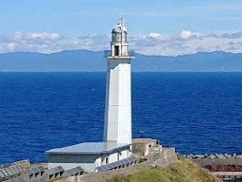
1923. Active; focal plane 43 m (141 ft); three white flashes every 30 s. 24 m (79 ft) octagonal concrete tower with lantern and gallery. Entire lighthouse painted white. Keeper's house and other light station buildings. A Coast Guard photo is at right, Kouhei Kawaguchi has a 2020 closeup, Tadayoshi Kosaka has a photo of the lighthouse on a foggy day, Vũ Hoàng has a 2023 photo and drone view, Trabas has Smith's distant view from the sea, and Google has a satellite view. In 2001 the lighthouse was equipped with an experimental "hybrid" power system that combined solar panels with a wind turbine and a generator powered by wave action. However, photos taken by a 2010 visitor (no longer online) showed that only the solar panels remain. Matsumae Kojima is an uninhabited volcanic island in the Sea of Japan about 25 km (15 mi) west southwest of Matsumae. Protected as a wildlife preserve, the island also has a harbor of refuge for fishermen. Located at the northeastern point of the island, adjacent to the harbor of refuge. Site and tower closed. ARLHS JPN-334; JCG-0643; Admiralty M6686; NGA 0992.
Matsumae Ōshima
1982. Active; focal plane 135 m (443 ft); white flash every 3 s. 12 m (39 ft) round cylindrical fiberglass tower with lantern and gallery, attached to a small service building. Lighthouse painted with red and white horizontal bands. Google has a satellite view. Matsumae Ōshima is an uninhabited volcanic island in the Sea of Japan about 50 km (30 mi) west of Matsumae. An eruption of the volcano in 1741 caused a destructive tsunami striking the neighboring mainland. The volcano is still active although there has been no major eruption since 1796. The island is protected as a scientific and wildlife preserve. The lighthouse is located on the southwestern side of the island. Accessible only by boat or helicopter (visitors require a special permit from the Agency for Culutural Affairs to land on the island.). Site and tower closed. ARLHS JPN-335; JCG-0644; Admiralty M6684; NGA 0988.
Matsumae Koshima Light
Koshima Light, Matsumae, 2001
Japanese Coast Guard photo

Information available on lost lighthouses:

Notable faux lighthouses:

Adjoining pages: Northeast: Southeastern Hokkaidō | South: Northern Honshū | Northwest: Southwestern Hokkaidō

Return to the Lighthouse Directory index | Ratings key

Posted July 10, 2006. Checked and revised April 25, 2023. Lighthouses: 36. Site copyright 2023 Russ Rowlett and the University of North Carolina at Chapel Hill.