Lighthouses of Japan: Yamagata

The nation of Japan, known in Japanese as Nihon or Nippon (日本), occupies an archipelago off the east coast of Asia. The four main islands are Hokkaidō in the north, Honshū (the largest) in the center, Shikoku in the south, and Kyūshū in the southwest. The country includes thousands of other islands of all sizes; among them the Ryūkyū (Nansei) Islands are a long chain extending to the southwest and including the large island of Okinawa, and the Nanpō Islands are another long chain extending south into the Pacific Ocean. Much of Japan is mountainous but the coastal regions are densely populated and urbanized; the country's population is about 126 million.

Japan is divided into 47 prefectures. This page lists lighthouses of Yamagata Prefecture on the northwestern coast of Japan's largest island, Honshū. Yamagata faces west on the Sea of Japan. Most of the prefecture is inland; the coastline is only about 60 km (38 mi) long. Sakata is the one major port.

In Japanese the word for a lighthouse is tōdai or toudai (灯台). The words saki and misaki are for capes and headlands, hana ("nose") is a promontory, hantō is a peninsula, shima (also spelled sima or jima) is an island, bae is a reef, iwa or shi is a rocky reef, amase or se is a shoal, wan is a bay, nada is a sound or basin, kaikyō is a strait, kawa is a river, and or minato is a harbor.

Lighthouses in Japan are operated and maintained by the Japanese Coast Guard's Maritime Safety Agency. On Honshū there is usually at least one Coast Guard Section Office in each prefecture. Lighthouses of Yamagata Prefecture are maintained by the Sakata office.

A note on the Sea of Japan/East Sea controversy: The Directory takes no side in any international dispute; it makes use of the terminology, names, and spellings as they currently exist in each area covered. The sea between Japan and Korea is called the Sea of Japan on the pages for Japan and the East Sea on the pages for Korea.

ARLHS numbers are from the ARLHS World List of Lights. JCG numbers are the Japanese Coast Guard's light list numbers. Admiralty numbers are from volume M of the Admiralty List of Lights & Fog Signals. U.S. NGA List numbers are from Publication 112.

Nezugaseki Misaki Light
Nezugaseki (Benten Shima) Light, Nezugaseki
Japanese Coast Guard Sakata Office photo

General Sources
Lighthouses in Japan - Yamagata
A site providing photos and data for most major Japanese lighthouses.
LighthouseJapan.com - Yamagata
Another comprehensive site with photos and notes from visits to many lighthouses.
Form of a Lighthouse - Yamagata
Another site with many photos and notes from visits to lighthouses; cited below as FOAL.
Misty's Japanese Lighthouse Tour - Yamagata
Photos and brief notes in English for lighthouses in all parts of the country.
Second District Lighthouses
Photos and information posted by the Coast Guard Second Region headquarters in Aomori. The first three lighthouses are in Yamagata.
Sakata Office Aids to Navigation
An interactive map links to photos and information on the major lights of Yamagata.
Lighthouses in Yamagata Prefecture
Photos by various photographers available from Wikimedia.
Online List of Lights - Japan
Photos by various photographers posted by Alexander Trabas.
Navionics Charts
Navigation chart for Yamagata.
Sakata North Breakwater Light
North Breakwater Light, Sakata, May 2010
ex-Panoramio photo copyright mbingm; permission requested
Tsuruoka City Lighthouses
* Nezugaseki Kō (Benten Shima)
1925. Active; focal plane 21 m (69 ft); two white flashes every 7 s. 14 m (46 ft) round cylindrical concrete tower with lantern and gallery, painted white. The photo from the Coast Guard's page is at the top of this page, Lighthouse-Japan.com has a page with good photos, FOAL's page also has good photos, Takeyoshi Iwata has a 2021 photo, Misty's Tour has additional photos, Satoru Inomata has a 2022 street view, and Google has a satellite view. The lighthouse is located on Benten Shima, a wedge-shaped island that has been connected to the mainland by a causeway separating the two halves of the harbor. Accessible by a paved pathway. Site open, tower closed. . ARLHS JPN-408; JCG-1363; Admiralty M7088; NGA 3428.
* Nezugaseki Kō West Breakwater
1962. Active; focal plane 15 m (49 ft); continuous red light with a more intense flash every 5 s. 11 m (36 ft) concrete post rising from a a square 1-story concrete equipment room. Entire lighthouse painted red. FOAL has a photo (3/4 the way down the page) and Google has a satellite view. Lighthouse-Japan.com also has photos of the similar but smaller light, painted white, on the north breakwater. Located at an elbow of the original west breakwater of Nezugaseki. Accessible by walking the pier. Site open, tower closed. ARLHS JPN-1181; JCG-1364; Admiralty M7088.4; NGA 3432.
Ryūtōan Shima
1955. Active; focal plane 16 m (52 ft); two white flashes every 5 s. 15 m (49 ft) round concrete tower with a small lantern, mounted on a conical stone base. Lighthouse painted black with a red horizontal band. The Coast Guard's page has the photo at right, FOAL has additional photos (lower half of the page), Lighthouse-Japan.com has a distant view, a 2020 drone view is available, Misty's Tour has a small photo, and Google has a satellite view. Located on a reef about 1 km (0.6 mi) off Hato Saki. Accessible only by boat but there is a view from the coastal highway (route 7). Site and tower closed. ARLHS JPN-2637; JCG-1366; Admiralty M7087.9; NGA 3444.
Ryūtōan Shima Light
Ryūtōan Shima Light, Nezugaseki
Japanese Coast Guard Sakata Office photo
* Hato Saki
1955. Active; focal plane 40 m (131 ft); white light, 3 s on, 3 s off. 10 m (33 ft) concrete post rising from a a square 1-story concrete equipment room. Entire lighthouse is white. Lighthouse-Japan.com has a page with several good photos, the Coast Guard's page has a good photo, FOAL's page has photos, Misty's Tour also has a photo, and Google has a street view and a satellite view. Located on a promontory about 8 km (5 mi) north of Atsumi. National route 7 passes close to the light; parking provided. Site open, tower closed. . ARLHS JPN-091; JCG-1367; Admiralty M7087.8; NGA 3440.
Yura Kō Outer Breakwater
Date unknown. Active; focal plane 16 m (52 ft); two red flashes every 5 s. 9 m (30 ft) round concrete tower with a flared top. Entire lighthouse is red. Google has a satellite view and a distant street view. Located on a detached breakwater protecting Yura harbor. Accessible only by boat. Site open, tower closed. JCG-1370.2; Admiralty M7087.35; NGA 3456.1.
* Ara Saki (Arasaki) (2)
1953 (station established 1903). Active; focal plane 33 m (108 ft); white flash every 5 s. 12 m (39 ft) concrete post rising from a a square 1-story concrete equipment room. Entire lighthouse is white. A photo is at right, the Coast Guard's page has a good photo, a 2005 photo is available, Lighthouse-Japan.com has a page with good photos, the FOAL page has photos, and Google has a satellite view and a distant street view. The lighthouse is adjacent to the Kamo Aquarium, known especially for its large collection of jellyfish. Located on a promontory at Kamo, about 10 km (6 mi) west of Tsuruoka. Site open, tower closed. . ARLHS JPN-024; JCG-1371; Admiralty M7087; NGA 3460.
* Kamo Kō (Arasaki) Inner Breakwater
1962. Inactive since 2015. This was an 8.5 m (28 ft) concrete post attached to a square 1-story concrete equipment shelter. Entire lighthouse is red. FOAL has additional photos (lower half of the page) and Google has a 2022 street view and a satellite view. Deactivated pierhead lights in Japan are usually removed but this one has been retained in place. Located at the end of the short west inner breakwater, a short distance east of the Kamo Aquarium. The Aquarium has ample parking. Accessible by walking the pier. Site open, tower closed. ARLHS JPN-1174; ex-JCG-1373; ex-Admiralty M7087.2; ex-NGA 3468.
* #Kamo Kō (Arasaki) North Breakwater
1968. Replaced in 2015. This was a 10 m (33 ft) concrete post attached to a square 1-story concrete equipment shelter. Entire lighthouse was white. FOAL has photos taken in 2014 (last row right and third from last row left) and Google has a 2012 street view. The lighthouse was replaced by a light on a post (focal plane 13 m (43 ft); green light, 3 s on, 3 s off) seen in Google's satellite view. Located at the end of the north (main) breakwater of Kamo harbor. Accessible by walking the pier. Site open, tower closed. ARLHS JPN-1175;. Active light: JCG-1372; Admiralty M7087.1; NGA 3464.

Ara Saki Light, Kamo, May 2016
Wikimedia Creative Commons photo by 掬茶

Sakata City Lighthouses
Built at the mouth of the Mogami River, Sakata is the only major port in Yamagata Prefecture. The city has a population of about 100,000.
Sakata Kō South Breakwater
1989. Reactivated (inactive 2010-2014); focal plane 17 m; two red flashes every 5 s. 16 m (52 ft) round concrete tower with lantern and gallery, painted red. FOAL's page has photos (halfway down the page), a closeup photo is available, A. Kikuchi has a 2019 photo, and Google has a satellite view. When the breakwater was extended in 2010 the lighthouse was deactivated in favor of a small light at the end of the extension. In 2014 the lighthouse was relocated to the end of the breakwater and reactivated. Located on the south breakwater at the mouth of the Mogami River in Sakata, the principal port of Yamagata Prefecture. Site and tower closed. ARLHS JPN-1183; JCG-1374; Admiralty M7084.5; ex-NGA 3480.
Sakata Kō North Breakwater
Date unknown. Active; focal plane 19 m (62 ft); two green flashes every 7 s. 14 m (46 ft) round white concrete tower with lantern and gallery. A 2010 photo is at the top of this page, FOAL has additional photos (halfway down the page), and Google has a satellite view. Located at the end of the north breakwater at the mouth of the Mogami River in Sakata. Site and tower closed. ARLHS JPN-1182; JCG-1375; Admiralty M7083; NGA 3484.
* Sakata (1) (relocated)
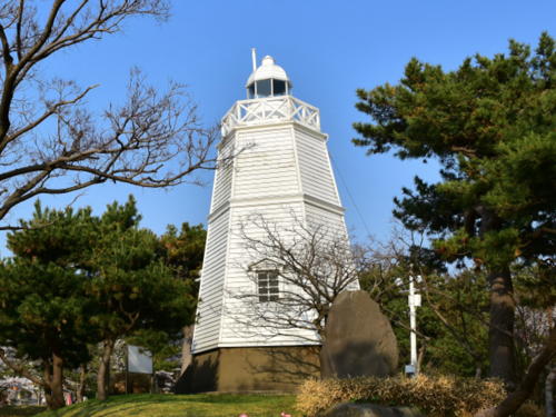
1895. Inactive since 1958 (a decorative light is displayed). Approx. 8 m (26 ft) hexagonal pyramidal wood tower with lantern and gallery, painted white. A 2018 photo is at right, another excellent photo is available, a 2022 closeup and additional photos are available, the Coast Guard has a historic photo, and Google has a satellite view. Claimed to be Japan's oldest wooden light, this historic lighthouse was built on the south side of the Mogami River entrance. In 2006 it was completely restored and relocated to a hilltop in Hiyoriyama Park, a city park on the north side of the river entrance in downtown Sakata. Parking provided. Site open, tower closed. Site manager: City of Sakata. .

1895 Sakata Light, Sakata, April 2018
Google Maps photo by k3 r910
* Sakata Groin
1979. Active; focal plane 14 m (46 ft); red light, 3 s on, 3 s off. 11 m (36 ft) square tapered skeletal tower, painted red. A 2019 photo is available, FOAL has additional photos (bottom of the page), a 2019 photo is available, and Google has a satellite view. Located on a short groin at the entrance to the inner north harbor basin of Sakata, about 500 m (0.4 mi) north of the new lighthouse. Apparently accessible by walking the groin. Site open, tower closed. JCG-1381; Admiralty M7082.5; NGA 3476.
**** Sakata (3)
2000 (station established 1895). Active; focal plane 41 m (135 ft); white flash every 8 s. 30 m (98 ft) square building with a lantern on the roof and a large enclosed observation deck wrapping around the seaward side about 3/4 of the way up. The building is white. Ishirugi Heihachiro's photo is at right, Takizawa Yasushi has a 2021 photo, FOAL has photos, Misty's Tour has two photos, Lighthouse-Japan.com also has a photo, and Google has a street view and a satellite view. According to tourist agency sources, since 1999 the building has been open to the public free of charge except during the winter, and the observation deck is the perfect place for watching the sun set into the Sea of Japan. Located on filled land on the Sakata waterfront. Site open, tower open daily in season. Site manager: City of Sakata. . ARLHS JPN-530; JCG-1380; Admiralty M7082; NGA 3472.
#Sakata (2)
1958. Inactive since 2000 and subsequently demolished. This was an 11m (36 ft) round cylindrical concrete tower with lantern and gallery. Entire lighthouse was white. Lighthouse-Japan.com has photos (second and last photos on the page) and the Coast Guard has a photo. Google has a satellite view of the former location, a short distance southeast of the current lighthouse and observatory.

Yuza Town Lighthouse
* Ugo Misaki
1960. Active; focal plane 68 m (223 ft); two white flashes every 7 s. 10.5 m (35 ft) concrete post rising from a a square 1-story concrete equipment room. Entire lighthouse is white. Lighthouse-Japan.com has a page with good photos, FOAL has a page with good photos, the Coast Guard's page also has good photos, a 2021 closeup is available, and Google has a satellite view. A more substantial building is shown in a 2002 photo, but we're not sure its location is specified correctly. Located on a promontory about 25 km (15 mi) north of Sakata, just south of the border between Yamagata and Akita prefectures. Accessible by a short walk, and parking is available, but the location is not marked. Site open, tower closed. . ARLHS JPN-710; JCG-1383; Admiralty M7077; NGA 3496.

2000 Sakata Light, Sakata, May 2017
Google Maps photo by Ishirugi Heihachiro

Tobi Shima Lighthouses
Tobi Shima is an island in the Sea of Japan about 40 km (25 mi) northwest of Sakata. Very popular with birders, the island has a population of about 300 and is accessible by ferry from Sakata. The island is administered by Sakata City.
* Tobi Shima (2)
Date unknown (station established 1948). Active; focal plane 82 m (269 ft); white flash every 10 s. 14 m (46 ft) round cylindrical white concrete tower with lantern and gallery, connected to a small equipment building or keeper's house. The photo from the Coast Guard's page is at right, FOAL has a page with good photos, another photo is available, Sun Waki has a 2021 photo, and Google has a satellite view of the station. Lighthouse-Japan.com has a photo of the original lighthouse taken about 1996; we do not know why or exactly when the lighthouse was replaced. Located on the highest point of the island. Site open, tower closed. . ARLHS JPN-657; JCG-1387; Admiralty M7076; NGA 3504.
Tobi Shima Kō Middle Breakwater
1962. Active; focal plane 13 m (43 ft); red flash every 3 s. 8.5 m (28 ft) concrete post rising from a a square 1-story concrete equipment room. Entire lighthouse is red. FOAL has photos, and Google has a street view and a satellite view. Located at the south end of the middle breakwater of Tobi Shima's harbor. Site open, tower closed. ARLHS JPN-1044; JCG-1385; Admiralty M7076.3; NGA 3508.
Tobi Shima Kō South Breakwater
1968. Active; focal plane 12 m (39 ft); green flash every 3 s. 8.5 m (28 ft) round concrete tower with a flared top, attached to a small 1-story concrete equipment shelter. Entire lighthouse is white. FOAL has photos and Google has a satellite view. Located at the original end of the south breakwater of Tobi Shima's harbor. Site open, tower closed. ARLHS JPN-1045; JCG-1386; Admiralty M7076.2; NGA 3512.
* [Tobi Shima South]
Date unknown. Active; focal plane 28 m (92 ft); three white flashes every 17 s. 7.5 m (25 ft) concrete post attached to a small equipment shelter. Entire lighthouse is white. FOAL has photos, another photo is available, and Google has a satellite view. Located near the southern tip of the island. Accessible by a short walk on a trail above the beach. Site open, tower closed. JCG-1384.9; Admiralty M7075.5; NGA 3513.
Tobishima Light
Tobi Shima Light
Japanese Coast Guard Sakata Office photo

Information available on lost lighthouses:

Notable faux lighthouses:

Adjoining pages: North: Akita | South: Niigata

Return to the Lighthouse Directory index | Ratings key

Posted August 15, 2006. Checked and revised May 18, 2023. Lighthouses: 18. Site copyright 2023 Russ Rowlett and the University of North Carolina at Chapel Hill.