Lighthouses of Japan: Iwate

The nation of Japan, known in Japanese as Nihon or Nippon (日本), occupies an archipelago off the east coast of Asia. The four main islands are Hokkaidō in the north, Honshū (the largest) in the center, Shikoku in the south, and Kyūshū in the southwest. The country includes thousands of other islands of all sizes; among them the Ryūkyū (Nansei) Islands are a long chain extending to the southwest and including the large island of Okinawa, and the Nanpō Islands are another long chain extending south into the Pacific Ocean. Much of Japan is mountainous but the coastal regions are densely populated and urbanized; the country's population is about 126 million.

Japan is divided into 47 prefectures. This page lists lighthouses of Iwate Prefecture, near the northeastern corner of Honshū, Japan's largest island. This coast, called the Rikuchū Coast (Rikuchū Kaigan), is mostly rugged and spectacular--and dangerous to navigation. For 180 km (115 mi) south of Kuji a narrow strip of land along the coast has been preserved as the Rikuchū Kaigan National Park. Most of these lighthouses are located in the park.

This coast was devastated by the Tōhoku earthquake and tsunami of 2011 March 11. Most of the lighthouses are high enough above the sea to escape the tsunami; most were damaged by the earthquake but all have been returned to service. A number of harbor lights were overturned or destroyed by the tsunami; most but not all have been replaced.

In Japanese the word for a lighthouse is tōdai or toudai (灯台). The words saki and misaki are for capes and headlands, hana ("nose") is a promontory, hantō is a peninsula, shima (also spelled sima or jima) is an island, bae is a reef, iwa or shi is a rocky reef, amase or se is a shoal, wan is a bay, nada is a sound or basin, kaikyō is a strait, kawa is a river, and or minato is a harbor.

Lighthouses in Japan are operated and maintained by the Japanese Coast Guard's Maritime Safety Agency. On Honshū there is usually one Coast Guard Section Office in each prefecture; for Iwate the section office is at Kamaishi.

ARLHS numbers are from the ARLHS World List of Lights. JCG numbers are the Japanese Coast Guard's light list numbers. Admiralty numbers are from volume M of the Admiralty List of Lights & Fog Signals. U.S. NGA List numbers are from Publication 112.

General Sources
Lighthouses in Japan - Iwate
A site providing photos and data for most major Japanese lighthouses.
Lighthouse-Japan.com - Iwate
Another comprehensive site with photos and notes from visits to many lighthouses.
Form of a Lighthouse - Iwate Prefecture
This web site, cited below as FOAL, has photos for many lighthouses in Iwate.
Lighthouse Visits
Another excellent source of photos of Japanese lighthouses.
Misty's Japanese Lighthouse Tour - Iwate
Photos and notes for lighthouses in all parts of the country.
Lighthouses in Iwate Prefecture
Photos by various photographers available from Wikimedia.
Second Region Lighthouse Story
Posted by the Coast Guard region office in Aomori, an interactive map linking to information on the major lighthouses.
Online List of Lights - Japan
Photos by various photographers posted by Alexander Trabas.
Navionics Charts
Navigation chart for Iwate.

Kuro Saki Light
Kuro Saki Light, Fudai, August 2010
Wikimedia Creative Commons photo by kumasan114

Hiruno Town Lighthouses
Taneichi Kō East Breakwater
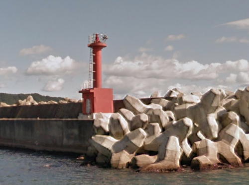
Date unknown. Active; focal plane 13 m (43 ft); two red flashes every 6 s. 10 m (33 ft) concrete post rising from a square 1-story equipment room. Entire lighthouse is red. FOAL has 2016 photos (lower half of the page) and Google has a satellite view and a distant 2014 street view. The tsunami's waves at Taneichi were 5.5 m (18 ft) high, enough to do major damage, but the lighthouses survived. Located at the end of the detached outer breakwater of Taneichi, a fishing port about 20 km (13 mi) southeast of Hachinohe. Accessible only by boat. Site open, tower closed. ARLHS JPN-1133; JCG-1627; Admiralty M6615; NGA 3948.
* Taneichi Kō
Date unknown. Active; focal plane 16 m (52 ft); continuous light, white, red or green depending on direction. 14 m (46 ft) round cylindrical white concrete tower. A photo (first photo on the page) and another photo (not quite halfway down the page) are available and Google has a street view (a portion is seen at right) and a satellite view. This is a leading light for vessels entering Taneichi. Located just behind the waterfront at Taneichi. Site open, tower closed. ARLHS JPN-1132; JCG-1628; Admiralty M6614; NGA 3952.
Yagi Kō East Breakwater
Date unknown. Active; focal plane 14 m (46 ft); continuous red light with a more intense flash every 3 s. 10 m (33 ft) round concrete tower with a flared top, attached to a small 1-story equipment room. Entire lighthouse is red. This light survived the tsunami. FOAL's page has a good photo (second row) and Google has a 2014 street view and a satellite view. Located at the end of the main breakwater of Yagi, about 10 km (6 mi) southeast of Taneichi. May be accessible by walking the pier. Site status unknown. ARLHS JPN-1140; JCG-1629; Admiralty M6613.3; NGA 3968.
Yagi Kō Entrance Range Front
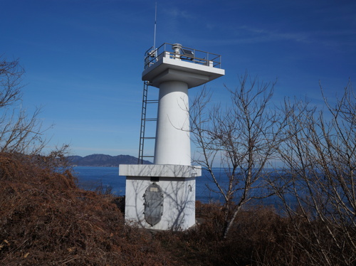
Date unknown. Active; focal plane 29 m (95 ft); continuous green light. 7.5 m (25 ft) concrete post rising from a square 1-story equipment room. Entire lighthouse is white. FOAL's page has photos (third row) and Google has a satellite view. Located on the slope above Yagi harbor. Site status unknown. ARLHS JPN-1141; JCG-1631; Admiralty M6612; NGA 3956.
Yagi Kō Entrance Range Rear
Date unknown. Active; focal plane 29 m (95 ft); continuous green light. 7.5 m (25 ft) concrete post rising from a square 1-story equipment room. Entire lighthouse is white. FOAL's page has photos (last two rows) and Google has a satellite view. Located on the slope above Yagi harbor. Site and tower closed (private property). ARLHS JPN-1142; JCG-1632; Admiralty M6612.1; NGA 3960.

Taneichi Kō Light, Taneichi, May 2014
Google Maps street view

Kuji City Lighthouses
Ushi Shima
Date unknown. Active; focal plane 71 m (233 ft); white light, 3 s on, 3 s off. 11 m (36 ft) concrete post rising from a square 1-story equipment room. Entire lighthouse is white. Google has a sea view and a satellite view. Located atop a steep-sided rock off a promontory about 5 km (3 mi) northeast of the Kuji waterfront. The rock is accessible by a walkway that is probably underwater at high tide. Site probably open with caution, tower closed. ARLHS JPN-320; JCG-1633; Admiralty M6608; NGA 3972.
Ushi Shima Hazard Beacon
Date unknown. Active; focal plane about 70 m (230 ft); continuous white light. 10 m (33 ft) semielliptical white concrete tower; the light is shown through a window. A. Kikuchi has a sea view and Google has a sea view and a satellite view. The light illuminates a reef about 1.1 km (0.7 mi) to the southeast. Located 40 m (45 yd) south of the main light. Site probably open with caution, tower closed. JCG-1634.
Kuji Outer Breakwater
Date unknown. Active; focal plane 14 m (46 ft); red light, 3 s on, 3 s off. 8.5 m (28 ft) concrete post attached to a square 1-story equipment room. Entire lighthouse is red. FOAL has a photo (third row left), and Google has a satellite view and a very distant street view across the harbor. Caution: there is another Kuji Kō in Ibaraki Prefecture. Located at the end of the main breakwater of Kuji. Site status unknown. ARLHS JPN-1137; JCG-1635.5; Admiralty M6610.3; NGA 3978.
* Kuji North Breakwater
Date unknown. Active; focal plane 15 m (49 ft); continuous red light with a more intense flash every 6 s. 10 m (33 ft) concrete post attached to a square 1-story equipment room. Entire lighthouse is red. FOAL has photos (fifth row left) and Google has a distant street view and a satellite view. Located at the end of the north breakwater of Kuji harbor. Accessible by walking the pier. Site open, tower closed. ARLHS JPN-1136; JCG-1635; Admiralty M6610; NGA 3976.
* Kuji South Breakwater
Date unknown. Active; focal plane 15 m (49 ft); continuous green light with a more intense flash every 6 s. 10 m (33 ft) concrete post attached to a square 1-story equipment room. Entire lighthouse is white. FOAL has a photo (bottom row right) and Google has a street view and a satellite view. Located at the end of the south breakwater of Kuji harbor. Accessible by walking the pier. Site open, tower closed. ARLHS JPN-1138; JCG-1636; Admiralty M6609; NGA 3980.

Noda Village Lighthouse
Noda Breakwater (Noda Wan)
Date unknown. Active; focal plane 13 m (43 ft); continuous red light with a more intense flash every 3 s. 9.5 m (31 ft) concrete post rising from a square 1-story equipment room. Entire lighthouse is red. Google has a sea view (also seen at right) and a satellite view. Note: There is another Noda Wan lighthouse in Shimane Prefecture. Located at the end of the main breakwater of Noda harbor, about 15 km (9 mi) south of Kuji. May be accessible by walking the pier. Site open, tower closed. JCG-1636.5; Admiralty M6607.5; NGA 3984.

Breakwater Light, Noda, October 2015
Google Maps sea view

Fudai Village Lighthouses
* Otanabe Kō
Date unknown. Active; focal plane 14 m (46 ft); green light, 2 s on, 2 s off. 10 m (33 ft) concrete post attached to a square 1-story equipment room. Entire lighthouse is white. Google has a sea view and a satellite view. Located at the end of the south breakwater of Otanabe harbor, on the north side of the Kuro Saki headland. Accessible by walking the pier. Site open, tower closed. ARLHS JPN-1121; JCG-1637; Admiralty M6607; NGA 3988.
*** Kuro Saki (Fudai, Rikuchū Kuro Saki)
1947. Active; focal plane 143 m (469 ft); white flash every 5 s. 12 m (39 ft) round cylindrical concrete tower with lantern and gallery, rising from a 1-story equipment shelter. Entire lighthouse painted white. A photo is at the top of this page, Lighthouse-Japan.com has a page with good photos, FOAL's page has photos, Misty's Tour has a photo, a 2021 closeup is available, and Google has a street view and a satellite view of the station. The light commands a spectacular view of the Pacific. Known locally as the Fudai Lighthouse, it is a very popular tourist attraction; there is a visitor center and museum and ample parking is provided. A monument on the path to the lighthouse marks latitude 40° north. Located on a high promontory at Otanable, about 25 km (15 mi) southeast of Kuji. Site open, tower closed. . ARLHS JPN-503; JCG-1638; Admiralty M6606; NGA 3992.

Tanohata Village Lighthouses
* Rikuchū Benten Saki
1966. Active; focal plane 98 m (322 ft); two white flashes every 7 s. 10 m (33 ft) round concrete tower with two galleries, mounted atop a square 1-story concrete equipment room. No lantern. Lighthouse painted with red and white horizontal bands. Takayuki Fujiwara's photo is at right, Lighthouse-Japan.com has a page with good photos, FOAL's page has photos, a 2021 closeup is available, and Google has a satellite view and a closeup street view. This lighthouse appears to be a twin of the Torii Saki Light in Aomori Prefecture, also built in 1966. It was reported out of service following the 2011 earthquake but it was repaired within a few months. Located about 4 km (2.5 mi) south of the Kuro Saki lighthouse; the two lights warn ships away from a dangerous bulge in the coastline. Accessible by a short walk from the Sankai Fireside Restaurant on highway 44. Site open, tower closed. . ARLHS JPN-502; JCG-1639; Admiralty M6605.8; NGA 3996.
Shimano Koshi (Shimanokoshi) Kō
Date unknown. Active; focal plane 14 m (46 ft); green light, 3 s on, 3 s off. 9.5 m (31 ft) concrete post attached to a square 1-story equipment room. Entire lighthouse is white. Google has a street view and a satellite view. The breakwater was largely destroyed by the tsunami but the lighthouse survived. Located at the end of the south breakwater of Shimano Koshi harbor, about 15 km (9 mi) south of Kuro Saki. Site status unknown. ARLHS JPN-1130; JCG-1640; Admiralty M6605.4; NGA 4000.

Imaizumi Village Lighthouses
* #Omoto (Kumanohana)
1963. Inactive since 2013 and demolished almost immediately. This was an 8.5 m (28 ft) round cylindrical concrete tower rising from a 1-story equipment room. Lighthouse-Japan.com has a page with good 2009 photos, a view from above the light is available, and Google has a satellite view of the tower's empty concrete pad. The National Park has developed the site as a viewpoint. Formerly located atop a bluff south of Omoto, about 25 km (15 mi) north of Miyako. Site open. ARLHS JPN-488; ex-JCG-1641; ex-Admiralty M6605.2; ex-NGA 4004.

Benten Saki Light, Tanohata, September 2019
Google Maps photo by Takayuki Fujiwara

Miyako City Lighthouses
Located at the head of a funnel-shaped bay, Miyako was among the communities hardest hit by the 2011 tsunami; the water reached a height of 37.9 m (124 ft) above sea level and 512 people were killed or never located. A YouTube video shows some of the appalling destruction caused by the great waves. In late 2011 the Admiralty reported that all of Miyako's harbor lights were destroyed and that buoys were in place.
* Ma Saki (Rikuchū Ma Saki)
1959. Active; focal plane 79 m (259 ft); two white flashes every 10 s. 9 m (30 ft) round cylindrical concrete tower rising from a 1-story equipment room. Heidi Ng's photo is at right, Lighthouse-Japan.com has a page with good photos, FOAL's page has photos, Misty's Tour also has a photo, and Bing has a satellite view. Located atop a steep, scenic promontory about 4 km (2.5 mi) northeast of Taro and 13 km (8 mi) north of Miyako. Accessible by a short but steep hiking trail. Site open, tower closed. . ARLHS JPN-504; JCG-1642; Admiralty M6605; NGA 4008.
[Tarō Kō (2)]
2013. Active; focal plane 13 m (43 ft); red flash every 3 s. 8 m (26 ft) post attached to a small equipment cabinet. Entire lighthouse is red. Google has a sea view and a satellite view. The March 2011 tsunami destroyed the original light. Located at the south end of a short detached breakwater at the entrance to the harbor, on the north side of Miyako. Accessible only by boat. Site open, tower closed. ARLHS JPN-1134; JCG-1643; Admiralty M6604.5; NGA 4012.
[Miyako North Breakwater (2)]
2014. Active; focal plane 11 m (36 ft); red flash every 4 s. 9 m (30 ft) post, painted red. Google has a sea view and a satellite view. The original lighthouse was destroyed by the 2011 tsunami; its replacement was activated in July 2014. Located at the end of the breakwater of Miyako's north harbor. Site status unknown. ARLHS JPN-1111; JCG-1644; Admiralty M6603; NGA 4020.
[Miyako Main (South) Breakwater (2)]
2014. Active; focal plane 12 m (39 ft); two red flashes every 6 s. 9 m (30 ft) post attached to a small equipment cabinet. Entire lighthouse is red. Google has a sea view and a satellite view. The original light was destroyed by the 2011 tsunami; its replacement was activated in July 2014. Located at the end of the breakwater of Miyako's north harbor. Site status unknown. ARLHS JPN-1110; JCG-1644.5; Admiralty M6603.5; NGA 4018.
Hei Saki
Date unknown. Active; focal plane 56 m (184 ft); white light, 3 s on, 3 s off. 10 m (33 ft) concrete post mounted at one corner of a 2-story concrete equipment building. Entire lighthouse painted white. A 2018 photo is available, FOAL's page has several photos, Lighthouse-Japan.com has a 2009 page with good photos, and Google has a satellite view. The attached structure seems to have been replaced sometime before the 2009 photo. Located on a promontory at the end of a long peninsula on the south side of the entrance to the harbor of Miyako. Accessible by a hiking trail from the nearby Ohana Fishing Port; local guidance will be needed. Site open, tower closed. . ARLHS JPN-103; JCG-1646; Admiralty M6602; NGA 4024.

Rikuchū Ma Saki Light, Miyako, March 2017
ex-Google Plus photo by Heidi Ng
Todo Saki (Todogasaki, Todo Ga Saki)
1902. Active; focal plane 58 m (190 ft); white flash every 15 s; a continuous red light is shone to the south southeast. 33.5 m (110 ft) concrete tower with lantern and gallery. A 3rd order (?) clamshell style Fresnel lens is in use. Entire lighthouse is white. A photo is at right, FOAL's page has several photos, Lighthouse-Japan.com has a page with good photos, Colum Duffy has a good closeup, a 2021 photo is available, the Coast Guard has a page with an aerial photo, Makoto Kuroda has closeup street view, and Google has a sea view and a satellite view. This handsome and historic lighthouse marks the easternmost cape of the island of Honshū. It was reported out of service following the earthquake and tsunami, but it was repaired within a few months. The lighthouse is in a rugged area accessible by a hike of about 2-1/2 hours round trip. Hikers are rewarded by spectacular views of the Pacific. Parking is available at the trailhead. Located about 25 km (15 mi) southeast of Miyako. Site open, tower closed. . ARLHS JPN-660; JCG-1647; Admiralty M6598; NGA 4028.

Yamada Town Lighthouses
Yamada Kasana Hana
Date unknown. Active; focal plane 11 m (36 ft); white flash every 4 s. 8 m (26 ft) concrete post attached to a square 1-story equipment room. A closeup photo is available, Takayuki Fujiwara has a 2022 photo, Google has a good sea view and an indistinct satellite view. This light seems to have survived the 2011 tsunami. NGA misspells the name as Kasano, and ARLHS misspells it as Kasaga. Located on a promontory at the entrance to Yamada Bay. Accessible only by boat. Site open, tower closed. ARLHS JPN-750; JCG-1649; Admiralty M6596; NGA 4040.
#Yamada Kō (1?)
Date unknown. Replaced in 2018. This was a 10 m (33 ft) concrete post attached to a square 1-story equiment shelter. Entire lighthouse is white. Google has a July 2013 street view and a 2015 sea view, and Bing has a fuzzy satellite view. The Admiralty reported in late 2011 that the harbor lights of Yamada had been destroyed and replaced by light buoys, but the street view suggests that this light survived. The FOAL webmaster visited in August 2016 and wrote that the harbor was "under restoration." A 2023 photo and Google's satellite view show that the lighthouse was replaced in 2018 by a post light (focal plane 12 m (39 ft); continuous green light with a more intense flash every 4 s). Located at the end of the main breakwater of Yamada. Site status unknown. ARLHS JPN-1143. Active light: JCG-1652; Admiralty M6597.35; NGA 4044.

Todo Saki (Todogasaki) Light, Miyako, October 2017
Wikimedia Creative Commons photo by 切干大根
Tarai Shima
Date unknown. 9 m (30 ft); two white flashes every 5 s. 7.5 m (25 ft) round concrete tower, painted black with one red horizontal band. FOAL has a photo (bottom of the page), a 2008 photo (a little over halfway down the page) is available, and Google has a sea view and a satellite view. Offshore lights generally survived the tsunami; the waves may have submerged them briefly but did not break over them. Located on a reef in the southeastern part of Yamada Bay. Accessible only by boat. Site open, tower closed. JCG-1654; Admiralty M6597; NGA 4048.
Rikuchū Ōshima
Date unknown. Active; focal plane 28 m (92 ft); white flash every 3 s. 11 m (36 ft) concrete post rising from a square 1-story equipment room. Entire lighthouse is white. Google has a sea view and an indistinct satellite view. Located on the south end of an island at the entrance to Funakoshi. Accessible only by boat. Site open, tower closed. ARLHS JPN-1112; JCG-1656; Admiralty M6595.1; NGA 4060.
Rikuchū Benten Shima
Date unknown. Active; focal plane 18 m (59 ft); white flash every 4 s. 11 m (36 ft) concrete post attached to a square 1-story equipment room. Entire lighthouse is white. A distant view (halfway down the page) is available, and Google has sea view and a satellite view. Located on the southeast end of an island at the entrance to Funakoshi, about 2.5 km (1.5 mi) northwest of the Ōshima light. Accessible only by boat. Site open, tower closed. ARLHS JPN-1099; JCG-1657; Admiralty M6595.5; NGA 4064.
#Funakoshi East Breakwater (1)
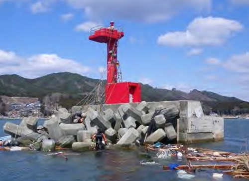
Date unknown. Demolished in 2011 after being damaged by the tsunami. This was a 9 m (30 ft) concrete post rising from a square 1-story equipment room. Entire lighthouse was red. The Coast Guard's post-tsunami photo of the original light (seen at right) shows JCG personnel searching for bodies that might be snagged at the end of the breakwater. The lighthouse was replaced by a post light (focal plane 10 m (33 ft); red flash every 3 s) seen on FOAL's page and Google's satellite view. Located at the end of the main breakwater (NGA calls it the north breakwater) at Funakoshi, a harbor on the south side of Yamada. Accessible only by boat. Site open, tower closed. Current light: JCG-1659; Admiralty M6595.7; NGA 4072.
Funakoshi East Breakwater Light
Funakoshi East Breakwater Light, Yamada, March 2011
Japanese Coast Guard photo (no longer online)


Ōtsuchi Town Lighthouses
Ōtsuchi Kō (Horai Shima) (2)
2012 (station established 1953). Active; focal plane 11 m (36 ft); red light, 3 s on, 3 s off. 7.5 m (25 ft) round hourglass-shaped concrete tower. Entire lighthouse is red. FOAL has photos (lower half of the page) and Google has a street view from shore, a sea view and a satellite view. The original light, a concrete post rising from a square 1-story equipment room, was destroyed by the tsunami. Lighthouse-Japan.com has photos of the original light and a 2008 photo (2/3 the way down the page) of the original light is also available. Located on an islet connected to shore by a pier. Accessible with caution by walking the narrow pier. Site open, tower closed. ARLHS JPN-1122; JCG-1663; Admiralty M6595; NGA 4084.
Ōtsuchi Shirahama Breakwater
Date unknown. Active; focal plane 12 m (39 ft); green flash every 3 s. 9 m (30 ft) concrete post attached to a square 1-story concrete equipment shelter. Entire lighthouse is white. A 2022 closeup photo is available and Google has a distant sea view and a satellite view. Located on the main breakwater of Shirahama harbor, on the south side of Ōtsuchi Bay. Site status unknown; probably accessible by walking the pier. JCG-1664.5; Admiralty M6594.5; NGA 4092.
Ohako Saki
Date unknown. Active; focal plane 71 m (233 ft); four white flashes every 15 s. 9 m (30 ft) round white concrete tower. A photo is at right, a 2022 photo and another photo (2/3 the way down the page) are available, and Google has a satellite view. Located high on a razor-sharp promontory about 16 km (10 mi) northeast of Kamaishi. Site status unknown. ARLHS JPN-475; JCG-1662; Admiralty M6594; NGA 4096.

Ohako Saki Light, Ōtsuchi, January 2018
ex-Google Plus photo by Gonzaburou Kitakaze

Kamaishi City Lighthouses
Ryioshi Wan (Naka Ne)
Date unknown. Active; focal plane 11 m (36 ft); two white flashes every 5 s. 10 m (33 ft) round concrete tower with gallery, painted black with one red horizontal band. FOAL has photos (on the right, first row in 2009, last row in 2016), another photo (2/3 the way down the page) is available, and Google has a satellite view. Located on a shoal in the center of Ryioshi Bay, an inlet about 5 km (3 mi) north of Kamaishi Bay. Accessible only by boat. Site open, tower closed. JCG-1665; Admiralty M6593; NGA 4100.
[Ryioshi Kō (2)]
2013. Active; focal plane 9.5 m (31 ft); continuous green light with a more intense flash every 5 s. 8.5 m (28 ft) white concrete post. FOAL has photos (next to last row), and Google has a satellite view. The original lighthouse, an 8.5 m (28 ft) concrete post rising from a square 1-story equipment room, was destroyed by the tsunami in 2011. FOAL has a 2009 photo (on the left, first row). Located at the east end of a detached breakwater of Ryioshi harbor. Accessible only by boat. JCG-1666; Admiralty M6593.2; NGA 4104.
#Madaga Saki
1971. Inactive and demolished. This was a 10 m (33 ft) round cylindrical concrete tower rising from a circular 1-story equipment room. Entire lighthouse was white. Google has a satellite view of the concrete pad where the tower stood. Located on a promontory on the north side of the bay of Kamaishi, about 6 km (3.5 mi) east of the city. Site open. ARLHS JPN-2635; ex-JCG-1667; ex-Admiralty M6589.2.
Kamaishi Kō (2)
2016. Active; focal plane 16 m (52 ft); two red flashes every 6 s. Approx. 14 m (46 ft) round cylindrical concrete tower with lantern and gallery. Entire lighthouse is red. Lighthouse Visits has photos and Google has a satellite view. The original lighthouse, a 10 m (33 ft) round cylindrical concrete tower attached to a small equipment room, was destroyed by the 2011 tsunami. Kamaishi had the world's deepest breakwater, built for tsunami protection, but the 2011 tsunami overwhelmed the barrier. Located at the south end of the north breakwater of Kamaishi. Site status unknown. ARLHS JPN-324; JCG-1671; Admiralty M6589.25; NGA 4108.
O Saki (Rikuchū O Saki)
1951. Active; focal plane 114 m (374 ft); white flash every 10 s. 15 m (49 ft) square cylindrical concrete tower with lantern and gallery, attached to a 2-story concrete equipment building. Entire lighthouse is unpainted white concrete. Yukihiro Matsumura's 2022 photo is at right, Kazutoshi Yamada has a 2019 closeup, Lighthouse-Japan.com has a page with several photos, and Google has a street view and a satellite view. Located on the tip of a long narrow peninsula that shelters the south side of the bay of Kamaishi, about 15 km (9 mi) east southeast of the city. It is a rather strenuous 6 km (4 mi) hike one way to the lighthouse. Site open, tower closed. . ARLHS JPN-505; JCG-1670; Admiralty M6589; NGA 4136.
Shikotsu (Sikotu) Saki
Date unknown. Active; focal plane 27 m (89 ft); white flash every 3 s. 10 m (33 ft) round hourglass-shaped concrete tower. Entire lighthouse is white. Google has a sea view and a satellite view. Shikotsu Saki is a rugged promontory about 15 km (9 mi) south of Kamaishi. Located on a small island off the tip of the cape. Accessible only by boat. Site status unknown. ARLHS JPN-1131; JCG-1677; Admiralty M6588.2; NGA 4144.

Rikuchū O Saki Light, Kamaishi, May 2022
Instagram photo by Yukihiro Matsumura
#Kojirahama Kō (1)
Date unknown. Destroyed by the tsunami in 2011. This was an 8.5 m (28 ft) concrete post rising from a square 1-story equipment room. Entire lighthouse was red. Google has a satellite view of the former location. The light was replaced by a buoy seen in Google's sea view and at the bottom of FOAL's page. In March 2018 a new 9 m (30 ft) light (focal plane 11 m, red flash every 3 s) was installed on the breakwater; Lighthouse Visits has a 2019 photo. ARLHS JPN-1108. New light: JCG-1678; Admiralty M6588.4; NGA 4140.

Ōfunato City Lighthouses
Kōbe Saki
Date unknown. Active; focal plane 124 m (407 ft); white flash eversy 5 s. 10 m (33 ft) round cylindrical concrete tower with gallery, rising from a 1-story concrete equipment shelter. Entire lighthouse is white. Gonzaburou Kitakaze's photo is at right, FOAL's page has closeup 2016 photos, Lighthouses in Japan has a distant view, and Google has a satellite view and a distant sea view. Located on the tip of a rugged peninsula about 8 km (5 mi) east of Ōfunato. Accessible by a hike of more than an hour along a closed service road (the FOAL webmaster reports this was one of the most difficult lighthouses to reach in his experience). Site and tower closed. . ARLHS JPN-270; JCG-1680; Admiralty M6587; NGA 4152.
[Rikuchū Sakihama Kō (2)]
2013 (?). Active; focal plane 11 m (36 ft); continuous red light with two more intense flashes every 8 s. 8.5 m (28 ft) red post. Google has a satellite view. FOAL has 2009 photos of the original lighthouse, an 8.5 m (28 ft) concrete post rising from a square 1-story equipment room; it was destroyed by the tsunami in 2011. Located at the end of the south breakwater of Sakihama, a fishing port sheltered by Kōbe Saki. Site status unknown. Site open, tower closed. ARLHS JPN-1124; JCG-1681; Admiralty M6586.6; NGA 4156.
Okirai (Okkirai) Kō East Breakwater (2)
2013 (?). Active; focal plane 12 m (39 ft); red flash every 3 s. 9 m (30 ft) post attached to a small equipment cabinet. Entire lighthouse is red. Google has a satellite view. FOAL has photos of the original lighthouse, a 9 m (30 ft) concrete post rising from a square 1-story equipment room; it was destroyed by the 2011 tsunami. The tsunami destroyed the breakwaters as well as the lighthouse. A beautiful bay just east of Ōfunato, Okkirai was devasted by the earthquake and tsunami. Located at the end of the breakwater. Accessible by walking the pier. Site open, tower closed. ARLHS JPN-1117; JCG-1682; Admiralty M6586.4; NGA 4160.

Kōbe Saki Light, Ōtsuchi, December 2017
ex-Google Plus photo by Gonzaburou Kitakaze
* Ryōri Saki
Date unknown. Active; focal plane 112 m (367 ft); white flash every 15 s. 16 m (52 ft) square cylindrical concrete tower with lantern and double gallery. Entire lighthouse is white. Gonzaburou Kitakaze's photo is at right, Lighthouse-Japan.com has a page with good photos, FOAL has photos from a 2016 visit, a 2021 photo is available, and Google has a satellite view. Located on the tip of a peninsula about 25 km (15 mi) southeast of Ōfunato. It is a fairly strenuous 5 km (3 mi) hike to the lighthouse. Site open, tower closed. . ARLHS JPN-512; JCG-1683; Admiralty M6586; NGA 4164.
Ryōri Kō Outer Breakwater (2)
2017. Active; focal plane 13 m (43 ft); two red flashes every 6 s. 10 m (33 ft) post centered on a square 1-story equipment building. Entire lighthouse is red. Google has a satellite view. The 2011 tsunami destroyed the original lighthouse and the entire breakwater. FOAL has distant views (top photo and second row right) of the lighthouse taken in 2009. The lighthouse was replaced by a buoy until new breakwaters could be built. Ryōri Kō is at the head of a narrow inlet and was devasted by the tsunami. Located at the end of the detached east outer breakwater of Ryōri, near the entrance to the inlet. ARLHS JPN-1126; JCG-1684.3; Admiralty M6584; NGA 4166.
#Ryōri Kō East Breakwater (1)
Date unknown. Destroyed by the 2011 tsunami. This was an 8.5 m (28 ft) concrete post rising from a square 1-story equipment room. FOAL has photos (top photo and second row left) taken in 2009. The light was apparently replaced by a post light seen in Google's satellite view but this light is not listed by JCG or the Admiralty. Located at the end of the east inner breakwater of Ryōri. ARLHS JPN-1127; ex-JCG-1684; ex-Admiralty M6585; ex-NGA 4168.
Ryōri Kō
1935. Inactive since 1967. Approx. 13 m (43 ft) round white concrete tower. FOAL has both 2009 and 2016 photos, a 2020 view from the sea is available, and Google has a satellite view and a distant street view. Located on a cliff adjacent to the west breakwater at Ryōri. The site is nearly inaccessible (the FOAL author could not find a way to reach it), but the lighthouse is easy to see from nearby.
Kōri Saki (Koori Saki)
1922. Active; focal plane 48 m (157 ft); white flash every 4 s. Approx. 15 m (49 ft) 2-stage concrete tower, lower stage square and upper stage round, with gallery but no lantern, rising from a 2-story concrete equipment shelter. Entire lighthouse is white. A 2018 photo is available, Lighthouse-Japan.com has a page with good photos, FOAL's page has photos, a 2022 closeup is available, and Google has a satellite view. This lighthouse serves as a landfall light for ships approaching the narrow entrance to Ōfunato Wan (bay), one of the best sheltered harbors of the Rikuchū coast. Located on a bluff about 12 km (7.5 mi) south southeast of Ōfunato. Difficult to locate, according to the Lighthouse of Japan webmaster. Site open, tower closed. . ARLHS JPN-275; JCG-1685; Admiralty M6582; NGA 4172.

Ryōri
Saki Light, Ōfunato, January 2018
ex-Google Plus photo by Gonzaburou Kitakaze
Ōfunato Wan North Breakwater (2)
2017. Active; focal plane 12 m (39 ft); red flash every 3 s. 10 m (33 ft) post centered on a sqaure equipment cabinet. Entire lighthouse is red. Google has a satellite view. This is a copy of the original lighthouse destroyed by the tsunami in 2011. The former light is at upper right in FOAL's distant view (first photo on the page). Located on a short detached breakwater on the north side of the entrance to Ōfunato Wan about 8 km (5 mi) south of Ōfunato. ARLHS JPN-1115; JCG-1686; Admiralty M6582.6; NGA 4184.
Sango Shima (Sangojima) South
Date unknown. Active; focal plane 19 m (62 ft); white flash every 3 s. 10 m (33 ft) round cylindrical white concrete tower. FOAL has a two views (second and fourth rows), a 2023 drone view is available, and Google has a sea view and a satellite view. Located at the southern tip of the teardrop-shaped Sango Shima, an island in the middle of Ōfunato Wan. Accessible only by boat. Site open, tower closed. ARLHS JPN-1129; JCG-1691; Admiralty M6583.5; NGA 4188.
Sango Shima (Sangojima) North
Date unknown. Active; focal plane 33 m (108 ft); white flash every 4 s. 8.5 m (26 ft) concrete post rising from a square 1-story equipment room. Entire lighthouse is white (NGA describes the light as being red). FOAL has a two views (second row, on the right, and last photo on the page), a 2023 drone view is available, and Google has a satellite view and a distant sea view. Located at the northern tip of Sango Shima. Accessible only by boat. Site open, tower closed. ARLHS JPN-1128; JCG-1692; Admiralty M6583.7; NGA 4192.
* Ōfunato Kō Directional Light
2002. Active; focal plane 53 m (174 ft); continuous light, white, red or green depending on direction. 14 m (46 ft) pentagonal cylindrical white concrete tower with gallery. FOAL's page has photos and Google has a street view and a satellite view. A passing light (JCG-1689.1), shown from the top of the tower, was deactivated in 2009. Located on the west side of the entrance to Ōfunato Wan about 4 km (2.5 mi) south of Ōfunato. Site open, tower closed. JCG-1689.2; Admiralty M6582.9; NGA 4196.
Ōfunato Wan South Breakwater (2)
2017. Active; focal plane 12 m (39 ft); green light, 3 s on, 3 s off. 9.5 m (31 ft) post centered on a small equipment cabinet. Entire lighthouse is white. Google has a satellite view. The original lighthouse was destroyed by the tsunami in 2011. That light is at upper left in FOAL's distant view (first photo on the page). Located on a breakwater on the south side of the entrance to Ōfunato Wan about 8 km (5 mi) south of Ōfunato. ARLHS JPN-1116; JCG-1687; Admiralty M6582.4; NGA 4180.
* Goishi Saki
1958. Active; focal plane 39 m (128 ft); three white flashes every 13 s. 10 m (33 ft) round cylindrical concrete tower with two galleries but no lantern, centered on an octagonal 1-story equipment shelter. Entire lighthouse is white. An observation deck below the lighthouse provides wide views of the Pacific. A photo is at right, Lighthouse of Japan has a page with good photos, Wikimedia has a photo, a 2020 closeup is available, Misty's Tour also has a photo, FOAL's page has photos from 2009 and 2016, and Google has a sea view and a satellite view. Located at the tip of a peninsula about 13 km (8 mi) south of Ōfunato. Accessible by road and a short, pleasant walk; parking is provided. Site open, tower closed. . ARLHS JPN-072; JCG-1693; Admiralty M6581; NGA 4208.

Goishi Saki Light, Ōfunato, August 2018
ex-Google Plus photo by Tomoko T

Rikuzentakata City Lighthouses
Tsubaki Shima
Date unknown. Active; focal plane 47 m (154 ft); white flash every 6 s. 10 m (33 ft) round hourglass-shaped white concrete tower. Google has a sea view and a satellite view. Located on an islet off a sharp promontory about 12 km (7.5 mi) southeast of Rikuzentakata. Accessible only by boat. Site open, tower closed. ARLHS JPN-1135; JCG-1694; Admiralty M6571; NGA 4216.
Akaiso Iwa
Date unknown. Active; focal plane 11 m (36 ft); one short and one long red flash every 3 s. 10 m (33 ft) concrete tower. Entire lighthouse is red. Google has a sea view and a satellite view. Located on a reef about 300 m (0.2 mi) off Hirota harbor in Hirota Bay. Accessible only by boat. Site open, tower closed. JCG-1695; Admiralty M6578; NGA 4224.
Hirota Kō
Date unknown. Active; focal plane 12 m (39 ft); continuous red light with a more intense flash every 4 s. 9.5 m (31 ft) concrete post rising from a square 1-story equipment room. Entire lighthouse is red. Fumihiro Ono has a 2022 photo and Google has a sea view and a satellite view. Located on the end of the main breakwater of Hirota harbor, on the east side of Hirota Bay. Site status unknown. ARLHS JPN-1100; JCG-1696; Admiralty M6579; NGA 4220.

Information available on lost lighthouses:

Notable faux lighthouses:

Adjoining pages: North: Aomori | South: Miyagi

Return to the Lighthouse Directory index | Ratings key

Posted August 15, 2006. Checked and revised June 8, 2023. Lighthouses: 55. Site copyright 2023 Russ Rowlett and the University of North Carolina at Chapel Hill.